Posts In The “Destinations” Category
Umbrella Falls spills 59 ft (18m) down a sloping wall near the headwaters of the East Fork of Oregon’s Hood River. The trail to the falls is a popular summer hike, and in the winter is part of a system of marked snowshoe trails at the Mt. Hood Meadows ski area. We hiked to Umbrella…
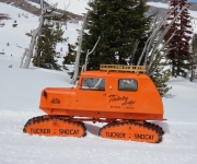
Distinctive bright-orange Tucker Sno-Cats have been operating at Timberline on Mt. Hood since the beginning of skiing in the area. They are so synonymous with the ski resort that the local Mt. Hood Brewing Company named a beer after the pair: the Timberline Tucker Double IPA. Featured on the label, and above, is a refurbished…
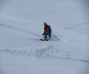
The Timberline ski area at 11,249 ft (3,429 m) Mt. Hood has the longest ski season in North America, operating from October through August in ideal years. From a maximum altitude of 8,540 ft (2,602 m), the winter vertical drop is 4,540 ft (1,383 m) and in the summer it’s 2,616 ft (797 m). The…
Government Camp, Oregon is the main settlement near the ski resorts at Mt. Hood. The town’s name derives from a government convey of munitions destined for Oregon forts that camped there in 1849. The convoy was following the Barlow Road, a toll road that was the last overland segment of the Oregon Trail before reaching…
Artist Point, at altitude 5,100ft (1,554 m) is a popular summer destination at Mt. Baker. A paved road leads right to the top, for spectacular mountain views. And a short hike along Kulshan Ridge leads to an even better viewpoint atop 5,247 ft (1,599 m) Huntoon Point. The road to Artist Point is unplowed and…
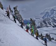
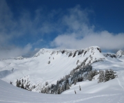
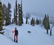
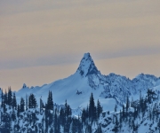
10,786 ft (3,288 m) Mt Baker has two major commercial ski bases, White Salmon and Heather Meadows, but also is a busy backcountry ski area. Rising above the Bagley Creek basin, the steep slope of 5,742 ft (1,750 m) Table Mountain is particularly popular and was covered with ski tracks when we visited. On our…
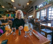
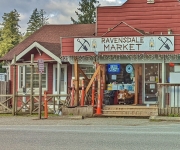
The waterfront city of Bellingham city lies just 21 miles (34 km) south of the U.S.-Canada border and is the closest major center to 10,786 ft (3,288 m) Mt Baker. We’d passed Bellingham many times in trips by car, and boat, to and from Canada, but had never spent much time there. On a weekend…
During a late-season heavy snowfall at Snoqualmie Pass, we returned to the Gold Creek Sno Park, this time to hike towards Kendall Peak Lakes. The season for this snowshoe hike typically extends to early March, but it was still viable mid-April with the several inches of fresh snow that had recently fallen. We were among…
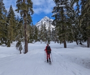
Snow Lake is the most popular summer hike in the Alpine Wilderness area of Wenatchee and Snoqualmie National Forests. The trailhead is just a one-hour drive from downtown Seattle, and reaching a viewpoint over the lake is an easy a 2.3-mile (3.7 km) hike from the trailhead with a modest elevation gain of 1,200 ft…
On our second day of snowshoeing at Mr. Rainier, we descended along the Lower Lakes trail from Paradise village along a marked intermediate snowshow trail. From there, we climbed up the south end of Mazama Ridge and followed it north, continuing back to the parking lot by retracing the previous day’s route up. Conditions were…
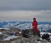
Panorama Point, on the flank of Mt. Rainier, is 6,964 ft (2,123 m) above sea level and aptly named. Mt. Rainier fills the sky to the north, the Nisqually River descends southwest, and southward the Cascade Range extends to the horizon, with clear views to 8,363-ft (2,549 m) Mt. St. Helens in Washington and 11,250-ft…
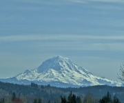
Mt. Rainier is the highest mountain in Washington at 14,411 ft (4,392 m) and is clearly visible at vantages throughout the state, including Seattle. The height makes it a popular, but difficult, mountaineering location. Each year about 10,000 attempt an ascent, but only about 5,000 reach the summit. Most ascents take 2-3 days, and the…
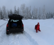
The Gold Creek Sno-Park, on the eastern side of Snoqualmie Pass, is one of more than 120 state-maintained public winter recreation areas in Washington. And being so close to Seattle, it is one of the more popular. A Sno-Park is simply a parking lot cleared of snow. Some support non-motorized use only, but two-thirds are…

When attending a sporting event, we often see fans of the away team. Sometimes they are wearing a simple shirt, coat or cap with their team’s logo and colors, but occasionally they are dressed in elaborate attire. The ‘Raider Nation‘ fans of the recently-relocated Los Angeles Raiders are particularly known for their fervor, demonstrated through…
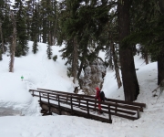
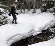
The Commonwealth Basin snowshoe route starts at the Snoqualmie Pass ski resort and follows Commonwealth Creek northeast towards the base of Red Mountain. The winter scenery along the way is varied and spectacular, ranging from snow-covered foot bridges in an intimate forest setting to frozen waterfalls to wide-open mountain vistas. And the higher-altitude climb up…
The snowshoe route to Skyline Lake at Stevens Pass is a popular one for its spectacular mountain views. The trail is reasonably short at 3 miles (4.8 km), but with an elevation gain of 1,100 ft (335m), it’s not a quick in-and-out. The mountain views along the way to the lake are excellent, but are…
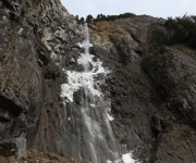
Snoquera Falls cascade 400 ft (122 m) over a cliff in the southern end of Mount Baker Snoqualmie National Forest near Mt Rainier. The volume of flow can vary dramatically from barely a trickle in the late summer to a torrent during the spring run-off, with the basin below filled with spray. An easy 2-mile…
On returning from our snowshoe trip to Olympic National Park, we decided to drive south through Tacoma for the first time rather than take a ferry across the Puget Sound as we’d done on previous trips. Surprisingly, driving the whole way only takes an extra 15 minutes over the ferry. But that’s assuming you just…