Posts In The “Washington State” Category
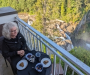
On a whim, we decided one morning to spend the night at Salish Lodge, and booked an awesome suite that night with a great view to Snoqualmie Falls. After lunch at nearby Snoqualmie Falls Brewery, we spent the rest of the day at Salish Lodge enjoying the room and the hotel, including an excellent dinner…
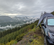
We didn’t expect to equal the view quality of the previous weekend’s campsite at Snowshoe Butte, but the one we found on the north side of Keechelus Ridge definitely was in the running. We’d camped on the south side of the Keechelus Ridge earlier in the year, with a vista west to to Keechelus Lake…
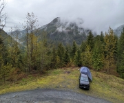
We arrived at the base of Snowshoe Butte after several hours of exploring without finding any appealing campsites. The area was completely fogged in at that point, and we couldn’t see a thing. But looking at our maps we felt there was a good chance the campsite had a view, so we decided to take…

Camping, like snowshoeing, initially held little appeal to us when we moved back to Seattle. We had camped a fair bit when we lived in Toronto in the late 1980s and enjoyed it. But we lost all interest in the activity following a miserable camping trip to Ontario’s Bruce Peninsula on a Labour Day weekend….

Slippery Creek is a tributary of the White River, that flows from the northeast flank of Mt Rainier and eventually through the Muckleshoot Reservation and later joins the Puyallup River to flow into the Puget Sound near Tacoma. Heading south from Seattle, we followed Slippery Creek upstream, first through the Muckleshoot Reservation and past their…
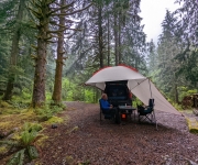
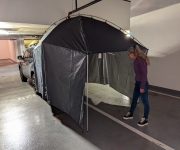
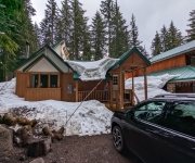
Even though we’d just returned from a two-night camping trip, we decided to head out for another night, this time to the Tinkham Campground in Mt Baker-Snoqualmie National Forest. We were eager to test our our new awning, and just couldn’t wait for the following weekend. It was a rainy Sunday night and we expected…
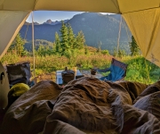
One of the aspects of wilderness camping that we really like is the opportunity to get out into the mountains and enjoy wonderful views. Finding the right campsite can take a bit of time, but we enjoy exploring and so far having been finding one excellent site after another, all with great views. Huckleberry Creek…
Amabilis Mountain, south of Keechelus Ridge, is a popular snowshoeing and cross-country skiing destination that is less-visited for summer hiking due to the number of better trails nearby. The winter recreation season was well over when we visited in mid-June, but snow still covered the road near the summit, resulting in few visitors to the…

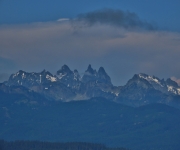
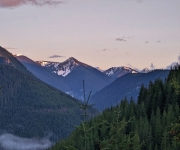
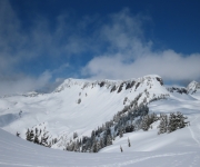
Keechelus Ridge rises 5,000 feet (1,525 m) above I-90 east of Snoqualmie Pass, separating Keechelus Lake directly west of the freeway from Kachless Lake to the east. National Forest roads crisscross the ridge, many with great views westward to Keechelus Lake, the Yakima River headwaters and the Cascade Mountain Range. And several good wilderness campsites…
Our first wilderness campsite was exactly what we were hoping for: secluded, with an interesting view and an opportunity for walking or hiking. After an initial test run of our camping gear at Bay View State Park, we went to look for a wilderness campsite at the Beckler River, near Stevens Pass in Mt. Baker-Snoqualmie…
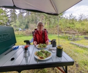
For our first time camping in 30 years, we reserved a site at Bay View State Park near Anacortes. All our new camping gear worked out very well, and we had a great time both at the campsite and walking the beach nearby. We were warm and comfortable sleeping in the truck, and the awning…
Earlier this year we decided to replace boat exploration with SUV exploration and wilderness camping. But, as with moving back Seattle in the first place, we were pretty much starting from scratch with camping gear. Besides the Engel HD30 cooler that we’d purchased for our road trip across the country, everything else had to be…

Snowshoeing didn’t initially appeal to us as a winter sport. The gear seemed cumbersome, and our perception was that we’d be mostly walking along level ground through snowy woods or meadows. While we enjoy winter scenery, that just didn’t strike us as very exciting. We had wanted to do more winter hiking, but were finding…
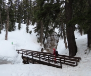
Umbrella Falls spills 59 ft (18m) down a sloping wall near the headwaters of the East Fork of Oregon’s Hood River. The trail to the falls is a popular summer hike, and in the winter is part of a system of marked snowshoe trails at the Mt. Hood Meadows ski area. We hiked to Umbrella…
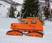
Distinctive bright-orange Tucker Sno-Cats have been operating at Timberline on Mt. Hood since the beginning of skiing in the area. They are so synonymous with the ski resort that the local Mt. Hood Brewing Company named a beer after the pair: the Timberline Tucker Double IPA. Featured on the label, and above, is a refurbished…
The Timberline ski area at 11,249 ft (3,429 m) Mt. Hood has the longest ski season in North America, operating from October through August in ideal years. From a maximum altitude of 8,540 ft (2,602 m), the winter vertical drop is 4,540 ft (1,383 m) and in the summer it’s 2,616 ft (797 m). The…
Government Camp, Oregon is the main settlement near the ski resorts at Mt. Hood. The town’s name derives from a government convey of munitions destined for Oregon forts that camped there in 1849. The convoy was following the Barlow Road, a toll road that was the last overland segment of the Oregon Trail before reaching…
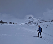
Artist Point, at altitude 5,100ft (1,554 m) is a popular summer destination at Mt. Baker. A paved road leads right to the top, for spectacular mountain views. And a short hike along Kulshan Ridge leads to an even better viewpoint atop 5,247 ft (1,599 m) Huntoon Point. The road to Artist Point is unplowed and…