
Lappeenranta lies on the south end of Lake Saimaa, about 3 nautical miles from the Saimaa Canal and about 16 from the Russian border. The town was charted in 1649, when it was part of Sweden and an important port for tar. The Swedes built a fortress there in stages in the 18th century, but soon after the town was annexed to Russia, and remained under Russian control until Finland gained its independence in 1917.
Today Lappeenranta has a population of about 73,000 and is the 13th largest city in Finland, with two universities having a collective 13,000 students from 68 countries. In the summer, the populations swells with tourists visiting the lake district and enjoying the towns many attractions, including numerous waterside cafes, the old fortress, and the Hiekkalinna (sandcastle) sculptures by artists from across Finland and internationally who gather each summer to carve a giant themed sandcastle.
Below are trip highlights from June 1st through 3rd, 2019 in and around Lappeenranta, Finland. Click any image for a larger view, or click the position to view the location on a map. And a live map of our current route and most recent log entries always is available at mvdirona.com/maps.
 |
Anchorage
Position: 61°5.50’N, 28°3.93’E
The view to islets off our lake anchorage northwest of Lappeenranta. We’ve had a busy past week, with the trip to St. Petersburg and the passage through Russia and the Saimaa Canal, so we wanted to find a nice anchorage to chill and catch up a bit. This one fit the bill perfectly.
|
 |
Spares
Position: 61°5.50’N, 28°3.93’E
We didn’t just chill and catch up, we also spent a good chunk of time chasing down a generator overheat issue. Here we have out one of our Really Useful Boxes full of small Northern Lights spares for a new temperature sender and gasket (at upper right) for the generator.
|
 |
Good News
Position: 61°5.50’N, 28°3.93’E
The washing machine was making a horrible racket as it spun, and we were concerned that it was developing a mechanical issue. On investigation we got two pieces of good news: 1) the washing machine was fine and 2) we found the extenstion that was missing after working on the generator.
|
 |
Industrial Facility
Position: 61°5.49’N, 28°3.92’E
It’s strange or at least a bit unusual that when in a wonderful all-nature surroundings, we actualy don’t mind the industrial facility in the distance. In fact, it kind of looks good in the evening light.
|
 |
Evening Light
Position: 61°5.49’N, 28°3.92’E
Golden light over the anchorage just past 9pm. The sun hardly sets now.
|
 |
Summer
Position: 61°5.49’N, 28°3.90’E
You know summer has arrive in Finland when people are out paddling shirtless.
|
 |
Anchorage
Position: 61°5.49’N, 28°3.92’E
At anchor in the islands northwest of Lappeenranta.
|
 |
100 Hours
Position: 61°5.52’N, 28°3.92’E
Our “new” tender now has 100 hours. That wound on in a hurry since last April.
|
 |
Lake Scenery
Position: 61°5.41’N, 28°3.37’E
The Saimaa Lake scenery looks fabulous in today’s wonderfully clear and calm weather.
|
 |
Lakefront
Position: 61°4.55’N, 28°0.51’E
Thousands of summer homes are in the Saimaa Lakes region, ranging from quite small and simple to large complexes like this one. But every one seems to have its own sauna, a hugely popular practice in Finland.
|
 |
Vanha Mikkelintie
Position: 61°2.57’N, 28°1.85’E
Looking back through the bridge carrying the road Vanha Mikkelintie to the picturesque channel we just came through in the tender.
|
 |
Industrial Building
Position: 61°2.27’N, 28°2.08’E
A picturesque brick building standing above a small lake likely is the ruins of some past industry in the area.
|
 |
Savilahdentie
Position: 61°12.58’N, 27°57.49’E
We’d planned a big tour by tender, but could see several bridges on the chart with no clearance information, so weren’t sure we could pass through. We cleared the first, under the road Savilahdentie, no problem.
|
 |
Suur-Saimaantie
Position: 61°11.17’N, 28°7.06’E
The final bridge to clear was under the road Suur-Saimaantie wasn’t a problem in the tender.
|
 |
Sailing Dinghies
Position: 61°4.28’N, 28°11.19’E
Sailing dinghies off Lappeenranta as we approached in the tender.
|
 |
Launching
Position: 61°4.12’N, 28°11.27’E
A steady stream of boats were being launched at Lappeenranta. The summer season is getting underway.
|
 |
Tour Boats
Position: 61°3.78’N, 28°11.23’E
Two tour boats moored in the harbour at Lappeenranta. The boat on the right is the Carelia that exited the Mustola lock in the Saimaa Canal heading in the opposite direction before we entered.
|
 |
Tender Moored
Position: 61°3.71’N, 28°11.23’E
Our tender moored at a guest float in downtown Lappeenranta.
|
 |
Prinsessa Armaada
Position: 61°3.74’N, 28°11.22’E
Lappeenranta has several waterfront cafes and restaurants, with many more inshore. We settled on the deck at the Prinsessa Armaada, a 1902 steamship that once carried logs to St. Petersburg. We had a good meal and loved the view to the inner harbour.
|
 |
Black-Headed Gull
Position: 61°3.74’N, 28°11.23’E
Handsome black-headed gull hoping for a handout.
|
 |
Lappeenranta
Position: 61°3.75’N, 28°11.19’E
Map of Lappeenranta and the surrounding area. The north end of Saimaa Canal is on the right, and Dirona is anchored near the top left.
|
|
|
Hiekkalinna
Position: 61°4.12’N, 28°11.06’E
Lappeenranta is known for its Hiekkalinna (sandcastle) sculptures, where artist from across Finland and internationally gather each summer to carve a giant themed sandcastle.
|
 |
Linnoitus
Position: 61°4.03’N, 28°11.02’E
Lappeenranta was founded in 1649 and the Swedish built a fortress in the hill above in the early 18th-century. The Russians continued building and expanding the fortress when the area came under their rule a few decades later. This map shows the fortress and the inner harbour behind. We had lunch in the corner of the harbour at top right.
|
 |
View from Linnoitus
Position: 61°4.02’N, 28°11.14’E
Looking north beyond some of the old Linnoitus fortress to the Lappeenranta harbour.
|
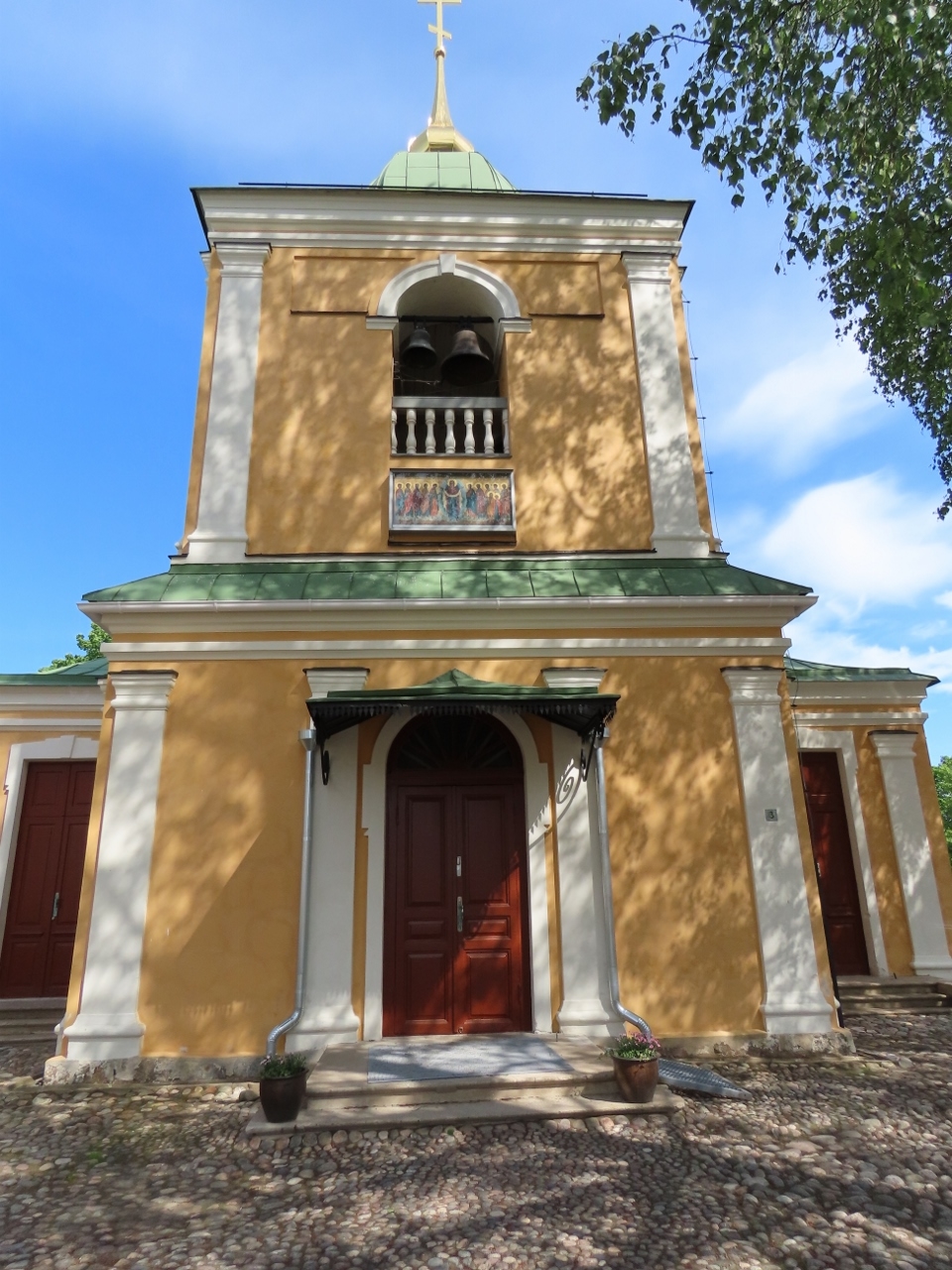 |
Orthodox Church
Position: 61°3.90’N, 28°11.02’E
The Orthodox Church in Linnoitus was completed in 1785, making it the oldest church in Finland.
|
 |
Lappeenranta Inner Harbour
Position: 61°3.84’N, 28°11.08’E
View southeast to the Lappeenranta Inner Harbour from the fortress Linnoitus. The Prinsessa Armaada, where we had lunch, is rightmost in the corner.
|
 |
Water Tower
Position: 61°3.57’N, 28°11.89’E
We could see the Lappeenranta water tower from a long distance away, so walked up in case it had a viewing platform. But the structure is not open to the public.
|
 |
Sports Field
Position: 61°3.72’N, 28°11.92’E
Large sports field near the Lappeenranta water tower.
|
 |
Tower
Position: 61°4.07’N, 28°10.10’E
We couldn’t decide the purpose of this single tower standing a distance from shore. We were tempted to climb the ladder to the top, but it’s getting close to the end of day.
|
 |
Fueling Tender
Position: 61°5.51’N, 28°3.93’E
We have two large bulk gasoline containers that we use to fill five smaller containers, and the tender. On this approach, we only need to take the bulk fuel containers out every second fueling. Because the bulk fueling containers are gravity drained, we pick them up with the crane.
|
 |
Rinsing Outboard
Position: 61°5.51’N, 28°3.93’E
When we put the tender away, we wash off the motor and we have put a hose quick-connect in the tender flush line so it’s quick to just plug in a hose, flush the engine with freshwater, and then easily disconnect it again.
|
 |
Click the travel log icon on the left to see these locations on a map, with the complete log of our cruise.
On the map page, clicking on a camera or text icon will display a picture and/or log entry for that location, and clicking on the smaller icons along the route will display latitude, longitude and other navigation data for that location. And a live map of our current route and most recent log entries always is available at mvdirona.com/maps. |
If your comment doesn't show up right away, send us email and we'll dredge it out of the spam filter.