Puumala sits on a chokepoint in the Saimaa Lakes region—all vessel traffic must pass through the 1000ft (300m) Puumalansalmi channel to reach the towns and cities to the north. Spanning the gap is the 2,562ft (781m) Puumalansalmi Bridge, one of the largest highway bridges in Finland. And built into the bridge is the Saimaanmajakka observation tower, with an elevator from sea level to the top for sweeping views across the area.
From our anchorage near Lappeenranta, we ran 42 miles to Suuri-Metiainen where we anchored for the night. From there we ran the tender around the peninsula to Puumala to check out the town and the view from the bridge.
Below are trip highlights from June 4th, 2019 en route to and around Puumala, Finland. Click any image for a larger view, or click the position to view the location on a map. And a live map of our current route and most recent log entries always is available at mvdirona.com/maps.
 |
Clearance
Position: 61°7.15’N, 28°6.43’E
Passing under the 34ft (10.5m) bridge between the islands of Kuivaketvele and Kuivisaari. We had plenty of room for our 29ft (9m) air draft, but it looks quite close.
|
 |
Mill
Position: 61°4.58’N, 28°13.88’E
Log mill and pulp and paper plant just outside Lappeenranta. The satellite imagery shows how extensive the facility is.
|
 |
Log Bundle
Position: 61°4.64’N, 28°14.26’E
We loved how this machine could pick up an entire truckload of logs in one “bite”.
|
 |
Phone Booth
Position: 61°7.66’N, 28°17.73’E
An unusual place to see a phone booth, lake-side below two cabins with nothing much of anything else around.
|
 |
Log Barge
Position: 61°7.34’N, 28°18.07’E
Forestry is a major industry in the Saimaa Lakes region. We saw several log-carrying barges and processing industries ashore.
|
 |
Ante
Position: 61°9.82’N, 28°23.17’E
The Russian-flagged cargo vessel Ante underway in Lake Saimaa.
|
 |
Kutveleen Kanava
Position: 61°19.51’N, 28°21.04’E
Passing through the Kutveleen Kanava (Kutvele Canal), the southernmost of four canals that make up Suvorov’s war channels, named after the Russian general who oversaw their construction (we saw a monument to Suvorov in St. Petersburg). Built in the late 18th-century as part of a Russian fortification system for southeast Finland, they are the oldest canals in Finland. The other three canals today either have no water or are too shallow for most boat traffic, but the Kutveleen Kanava was renewed and widened twice in the 20th century to allow larger ship traffic.
|
 |
Cable Ferry
Position: 61°27.07’N, 28°10.38’E
Cable ferry just west of Kutveleen Kanava.
|
 |
Puumalansalmi Bridge
Position: 61°31.20’N, 28°10.55’E
We anchored at Suuri-Metiainen and ran the tender around to Puumala. Here we are approaching the Puumalansalmi Bridge that we’ll pass under tomorrow in Dirona. The tower at the left end of the bridge has an elevator up to the bridge deck level and a further two floors up to a cafe in the top.
|
 |
Norppa
Position: 61°31.19’N, 28°10.70’E
Our tender tied off to a small dock just below the Puumalansalmi Bridge. Norppa means ringed seal, an endangered species unique to the Saimaa Lakes region.
|
|
|
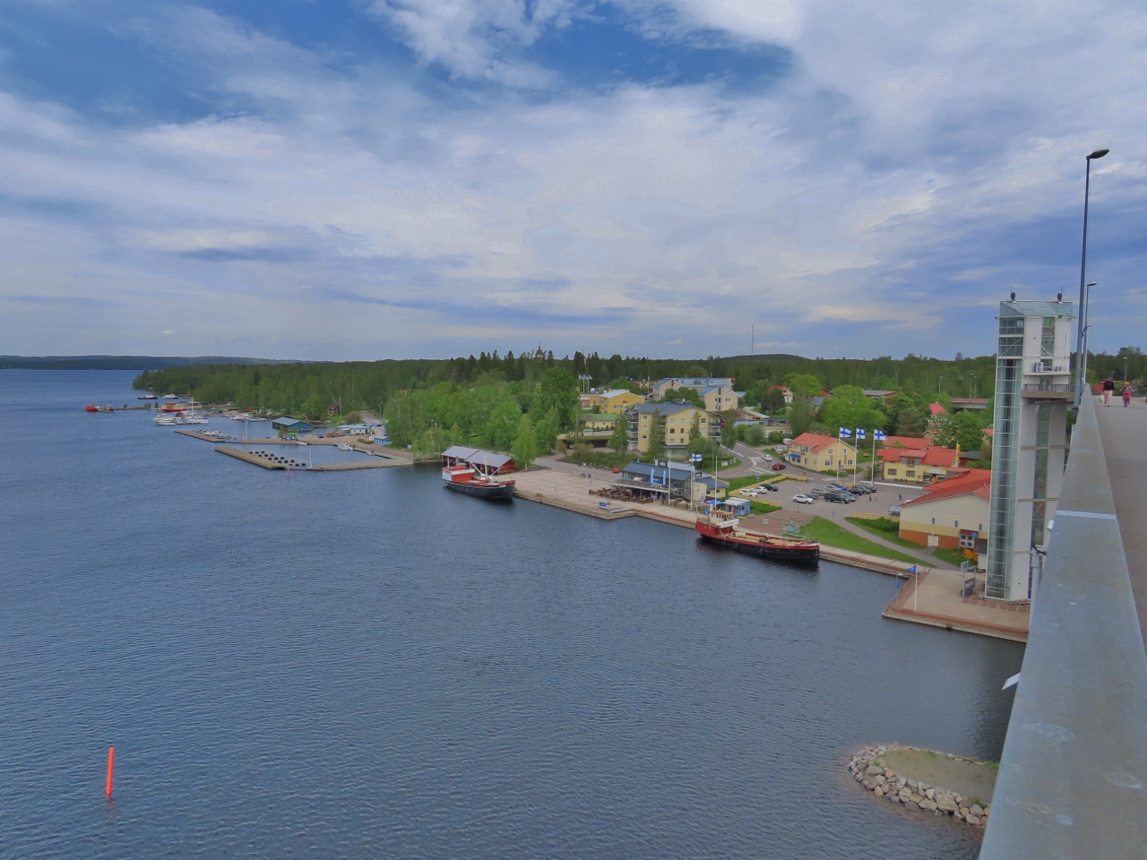
Puumala
Position: 61°31.14’N, 28°10.57’E
We took the elevator at right up to the bridge deck for great view of the area. This is looking northeast to Puumala.
|
 |
Puumala Church
Position: 61°31.49’N, 28°10.61’E
The light-filled interior of the Church of St. John the Baptist in Puumala. The first church that stood here was built in the 14th century, but was destroyed when Russia invaded Finland in 1712. The parish eventually raised the funds to complete a new one in 1751, and within forty years it too was destroyed during the Russo-Swedish war. The current church has fared better, and has stood since 1823.
|
 |
Ice Cream
Position: 61°31.36’N, 28°10.66’E
Pingviini (Penguin) brand ice cream vendors are common in Finland and Jennifer couldn’t walk past another without trying one. The delicious product is made from Finnish milk and cream.
|
 |
Pilot
Position: 61°31.43’N, 28°10.26’E
Pilot boat at Puumala.
|
 |
Suuri-Metiainen
Position: 61°30.31’N, 28°8.69’E
We’d noticed a park sign on Suuri-Metiainen as we arrived, so landed to investigate after we returned to the anchorage from Puumala.
|
 |
Shelter
Position: 61°30.30’N, 28°8.67’E
The park on Suuri-Metiainen was a small shelter designed for those arriving by boat.
|
 |
Anchorage
Position: 61°30.46’N, 28°8.63’E
View to our anchorage from a bluff on Suuri-Metiainen.
|
 |
Evening Sun
Position: 61°30.43’N, 28°8.55’E
James and Spitfire enjoying the late evening sun from the cockpit.
|
 |
Click the travel log icon on the left to see these locations on a map, with the complete log of our cruise.
On the map page, clicking on a camera or text icon will display a picture and/or log entry for that location, and clicking on the smaller icons along the route will display latitude, longitude and other navigation data for that location. And a live map of our current route and most recent log entries always is available at mvdirona.com/maps. |
If your comment doesn't show up right away, send us email and we'll dredge it out of the spam filter.