
This post discusses the reasons a boat owner might choose to carry deck fuel and the impact of deck fuel on the vessel’s stability. We start by explaining why a boat’s “real ocean” range is actually far less than the ranges advertised, and sometimes even less than the ranges carefully measured by owners. Then we discuss why an owner of an ocean crossing capable boat might still choose to carry deck fuel. Finally we’ll look in detail at the impact of deck fuel on stability using data from our Nordhavn 52 as an example.

Nordhavns are designed to be able to cross oceans and buyers of these boats frequently do so. The boats have the fuel capacity to make the trip possible and the combination of stability and strength to allow a crossing to be made without unreasonable risk. Nordhavns really are ocean crossing boats: over 150 ocean crossings have been completed in these boats, 8 have rounded the world, and ours has crossed every ocean and the Atlantic twice (Passagemaking Stats).

On fuel capacity, it’s easy to make mistakes and seriously underestimate what is required. Most data we’ve seen from boat manufacturers over the world makes our eyes roll. In fairness, these mostly are honest mistakes rather than an attempt to fool buyers. As an example of what can happen, we’ll use date from our own boat as an example.
Shortly after taking delivery of Dirona the engine manufacturer, John Deere, took the boat out for a fully-instrumented sea trial. They brought on board a suitcase of electronic equipment and multiple laptops. Once the engine was fully instrumented we went out into the Puget Sound and did a fully-instrumented two way pass at each RPM from idle to full-rated RPM. Deere was doing it to get application data on their 6068AFM75, but what we were getting in return was precise fuel burn data so we could plan trips with confidence.

The results of the test were nothing short of amazing. We learned Dirona could go 3,191 nautical miles at 7 knots and, if we slowed down to 6 knots, it would go 4,527 nautical miles. We couldn’t imagine ever needing to go more than 4,000 nautical miles between fuel stops but, it was nice to know that, if we slowed down further to 5 knots, we could stretch it out to 6,772 nautical miles.
We are very confident this data was accurately recorded and we think it does accurately reflect what Dirona can do in dead flat water with no wind and a light load. But, even though the data measured during the sea trial was precise, there were two things wrong with it: 1) the fuel capacity of a boat from topped-off tanks until no more fuel can be drawn from the tanks is not the manufacture’s published number (and it’s rarely more :) ), and 2) real-world ocean conditions are completely different from inshore test conditions.
On the boat’s fuel capacity, the only way to know for sure is to run a tank down until fuel will no longer pickup and then incrementally fill the tank, calibrating the gauges. This gives the real fuel capacity of the boat and we’ve seen some fairly large discrepancies between manufacturer-reported numbers and reality. As with range, these often are honest mistakes rather than an attempt to fool buyers, particularly on semi-custom boats.
Even if the tank size is known precisely, running them down to empty and then refilling is an opportunity to calibrate whatever tank measurement system you are using. On Dirona we use sight gauges and a Maretron FPM 100 with pressure sensors installed in the bottom of each tank. Knowing the real fuel capacity and exact amount on board allows the fuel to be used more fully on a long trip. If you don’t know the fuel remaining for sure, you have to be conservative. And, when you are 1,000 miles from shore, if you aren’t sure, you need to be unusually conservative. Knowing accurately how much fuel remains can effectively extend the range of the boat. With precise data, the operator will be much more willing to use the entire fuel load (excluding reserve).

|
Knowing the fuel available for the trip is fairly easy. What’s more challenging is determining the range of the boat in real ocean conditions. We found the difference between a carefully instrumented flat water run and real ocean conditions surprising. Fortunately, we didn’t take our computed 4,527 nautical mile range and just start across an ocean. We approach learning to do big trips by first doing smaller trips and collecting lots of data. Perhaps the best picture of a boat’s mileage in real ocean conditions is to look at a long run where ocean currents didn’t play a strong factor. Our longest trip is the 3,689 nautical mile run from St. Helena in the South Atlantic to Barbados. Here’s what we got:
- Average Speed: 6.0 kts
- Gallons per hour: 3.9
- Nautical miles/gallon: 1.6
We like this data because it’s a long trip in typical ocean conditions. This particular trip had some fairly long periods with unusually negative currents off the shore of Brazil but we use the data anyway mostly because we want our example to be conservative—we don’t want plan a trip and find that conditions are worse than we expected. Using this data, our computed 4,527 nautical mile range boat is actually 2,796. If we reserve 10% of our capacity, then we have 1,573 gallons to work with and that will give us 2,517 nautical miles of “real ocean” range with good reserve.

We’ve always used a 2,400 nautical mile range as what you would need for a go anywhere boat. That is sufficient to cross any ocean. We suspect it’s no fluke that the real range of the Nordhavn 52 is very close to this mark. Jeff Leishman, the boat’s designer, will have carefully managed the trade-offs between space given up to fuel, boat stability in ocean conditions, and range of the boat. He wants a design that can easily and comfortably cross oceans without sacrificing too much in the tens of design dimensions in conflict with extremely long range.
If Dirona can easily go 2,500 nautical miles with 10% reserve, we can cross any ocean. Why go to the hassle of carrying deck fuel and what is the negative impact of deck fuel on stability? In the famous words of an early aviator “the only time there was too much fuel aboard any aircraft was if it was on fire.” Fuel is freedom and option value. If you have more fuel, you can increase speed and potentially decrease weather risk. If you have more fuel, there are more alternative destinations possible in the event that a large storm system develops as the trip progresses. Some times more fuel is just a matter of better economics. For example, when we left Cape Town, South Africa, we fueled for only $2.85 per gallon whereas fuel at our next stop in St. Helena was $6.89 per gallon. We didn’t need to carry deck fuel for that trip, but the additional 960 gallons we brought along saved us $3,878. Ironically that trip alone paid for considerably more than half the cost of our deck fuel bladders.
Another motivation to be able to carry more fuel is to allow more direct routings. For example, most small boats cross the Indian Ocean via Cocos Keeling which adds 500-1000 miles to the ocean passage, depending if you depart from Broome or Darwin. We’re told Cocos Keeling is a very nice island, and with that routing Dirona could easily make the trip with only internal tanks. But we wanted to gain experience in longer crossings. Also fueling in Cocos Keeling would have been incredibly expensive. At the time, diesel was AUS $2/liter there, with no GST rebate. And we couldn’t reach the fuel dock due to shallow water, so we’d need to be supplied via barge. The cost of hiring the barge would make the effective price about $5/L or nearly $20 per gallon. That would have been a very expensive trip. So we opted to make the crossing directly from Dampier, Australia to Mauritius. At 3,000 nautical miles, this was outside of our range. But it’s an easy run with deck fuel. And we paid only AUS $1.09/L in Dampier with GST and fuel excise tax rebates.
 |
There are many good reasons why you might want to carry more fuel than is absolutely needed for a given trip. Summarizing some we have mentioned so far, 1) more direct routing, 2) additional speed to reduce weather risk, 3) fueling in less expensive locations, and 4) additional reserve against unusual or unlikely events. But there are also disadvantages. The first is minor but relevant: it takes a couple of hours to get the bladders out and ready to go. There is some overhead to using them. The second is cost. We think ATL has a good, strong product at a reasonable price but it’s still just over $2,000 for each 300-gallon bladder in a commodity size. We actually effectively paid for half the cost of the bladders from the savings from the Cape Town to St. Helena trip alone. Avoiding fueling in Cocos Keeling might have paid for the rest so the cost isn’t much of a consideration at this point. What does stay relevant for safety conscious boaters is boat stability.
When deck fuel bladders are added to a boat, it’s all weight above the boat’s center of buoyancy. From our perspective, this is by far the largest concern with deck fuel. For us, all the positives of being able to carry extra fuel far outweigh the negatives as long as the boat remains safe. There is no number of positives that would cause a rational person to go to sea in an unstable boat. Let’s look at the impact of deck fuel on the stability of the Nordhavn 52.
A Nordhavn 52, as with all ocean-going Nordhavns, is designed to meet the standards of “Category A Ocean.” We asked Nordhavn Engineering Manager Phil Arnold what exactly Category A means:
Standards organizations and classification societies have set up minimum acceptable stability criteria for all sorts of boats and ships in all sorts of conditions. For small craft the defacto stability standard is ISO 12217 (for a Nordhavn sized boat it, is ISO 12217-1 which assesses stability for non-sailing boats 6m long and over). It is a rigorous process – In the standard’s 75 pages it defines several criteria the boat must meet and the load condition the boat must be in when it is tested. Based on test results, each boat is assigned a Design Category between Category A, the most stringent, and Category D, the least demanding. For a Category ‘A’ boat testing criteria includes down flooding height, down flooding angle, offset loading, resistance to waves and wind and the size of water holding recesses. The categories are based on the sea state and wind conditions the boat could reasonably operate in assuming good seamanship. Nordhavns all leave the factory able to achieve Design Category A AND with a warning that additional top weight will adversely affect stability.
Most owners of US Nordhavns don’t bother to get their boats CE certified but it’s a common practice in Europe, so we asked Aaron Kagon to help with more background on the CE classification levels. At the time Aaron was a Solent University (Southampton UK) Yacht Design student who has now graduated with a BEng Honors degree. Aaron replied:
“Category A” refers to a Design Category as described in the European Union (EU) Recreational Craft Directive (RCD). The RCD provides requirements for the design and construction of recreational craft to be built for use in the EU. It is the most comprehensive small craft standard for recreational boats in the world, covering everything from exhaust and noise emissions, construction scantlings, stability and load capacity, electrical, plumbing and other system requirements, to fire protection and numerous other requirements. The RCD defines four Design Categories, from “A” to “D”, Category A being the most stringent. From the RCD: “A recreational craft given design Category A is considered to be designed for winds that may exceed wind force 8 (Beaufort) and significant wave heights of 4m and above . . .” To achieve a CE Category A, the boat must meet the requirements of numerous International Standards Organization (ISO) standards relating to the size and type of boat being built.
This is the definition of Category A:
7.2.1 A boat given design category A is considered to be designed to operate in winds of Beaufort force 10 or less and the associated wave heights, and to survive in more severe conditions. Such conditions might be encountered on extended voyages, for example across oceans, or inshore when unsheltered from the wind and waves for several hundred nautical miles. Winds are assume to gust to 28 m/s.
Phil Arnold did the stability calculations for a Nordhavn 52 both with and without the deck fuel tanks we often carry:
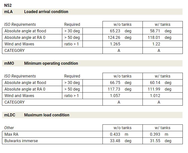
Complete definitions of the terms above are at ISO 12217-1:2015 Small craft — Stability and buoyancy assessment and categorization, and a summary is below:
- minimum operating condition is with crew, non-edible stores and equipment normally carried on the boat and not included in the manufacturer’s list of standard equipment, and residual fluids needed to operate the boat, excluding contents of main storage tanks.
- maximum load condition is with the maximum load the boat is designed to carry, including crew, non-edible stores and equipment, liferafts and dinghys, and all permanently installed storage tanks filled to 95% of their maximum capacity, including fuel, drinking water, black water, and grey water.
- loaded arrival condition is maximum load condition with the built-in tanks 15% full and carrying only 10% of edible stores and the worst combination of optional fittings or equipment with respect to stability
The good news is the Nordhavn 52 still meets CE Category A standards when carrying the full load of deck fuel we use for our longer trips. The amazing thing is that if we were crazy enough to empty the main tanks but keep the bladders full, it would still just barely squeak in as Category A. Of course, we would never do that. The moment we have consumed enough fuel from the built-in tanks, we pump the 360-gallon forward bladder dry and bring the built-in tanks back up to full. Once we have taken the main tanks down another 600 gallons and have room for the contents of the two cockpit bladders, we repeat the process and pump their contents below deck and again return the boat to full built-in fuel load. It feels weird to be more than a week offshore and still have full tanks.
Let’s look into this data in more detail. The Category A standard requires that the absolute angle at flood be more than 30 degrees. On our boat, this is the point of heel where the engine intake vents go under water. On the Nordhavn 52 under minimum operation conditions, this angle is 66 degrees without deck fuel and, with the deck fuel on board, it drops back to a lower but still respectable 60 degrees. Incidentally, we have some experience with this angle of incline, having once taken the boat to 69 degrees. And we can confirm the calculations. The boat does takes on water at this point of incline (69.1 Degrees).
The next important line is “absolute angle at a righting angle of 0”. This is the point where the boat has been leaned over until it is in equilibrium and there is no longer any righting force. Here we see 117 degrees on the Nordhavn 52 under minimum operating conditions without deck fuel and 111 degrees with the deck fuel. Again both data points are quite good. The Nordhavn 52 a remarkably stable small boat.
To summarize what we have learned so far.
- Generally, if you plan to cross an ocean or push the range of a boat, it’s wise to both explicitly run the tanks to the point where the engine no longer picks up fuel and then calibrate the level gauges by filling the tank progressively in small increments to the top. Knowing the fuel level helps ensures that you won’t make a mistake and attempt to use more than you have. And knowing the level with accuracy allows smaller reserves to be safely used.
- It’s important not to believe even the most accurately computed near-shore fuel economy tests. Open ocean conditions with wind, current, and waves are almost always worse and can be far worse. Knowing the boat’s real consumption makes any long trip safer.
- Even if a boat has the capacity to cross oceans without deck fuel, there may still be reasons to carry additional fuel for some trips.
- If you are interested in deck fuel, ensure your boat has the reserve stability to carry the fuel load safely.
For boats on the smaller end of the ocean-crossing power boat spectrum, deck fuel can be a nice way of increasing the options and having more direct routing available.
Further reading:
- Fuel Option Value, Speed & Safety
- Fuel For the Crossing
- Preparing for the North Atlantic Crossing
- Video: Preparing for the North Atlantic Crossing
Example trips with fuel burn:
- St. Helena/Barbados (3,689nm)
- Dampier Australia/Rodriquez Mauritius (3,023nm)
- Newport Rhode Island/Kinsale Ireland (2,801nm)
- Honolulu Hawaii/Nuku Hiva, Maquesas (2,5500nm)
- Cape Town/St. Helena (1,713nm)
Background data:
- ISO 12217 Stability Standard : Small Craft—Stability and Buoyancy Assessment and Categorization—Part 1: Non-sailing boats of hull length greater than or equal to 6 m
- Bladder supplier: Aero Tec Laboratories
- Boat Builder: Nordhavn 52

Not quite clear to me: have you ever run your tanks completely dry to calibrate your measurement system? Would it be a one-time thing, or is there an advantage to doing it every “x” years in case there is some drift?
Also, many Nordhavns have “day tanks”, including the 52s:
* https://www.nordhavn.com/models/52/specs/plumbing.php
Do you find it useful?
Yes, we have a 65 gallon day tank and find it very useful. The way we use the system is we run all engines off the day tank and the main tanks are sealed off. That way if there is a fuel leak, we can lose no more than 65 gallons before discovering and fixing the problem. Loosing all your fuel at sea would be a very bad thing. On engine room inspections at shift changes, we pump fuel from the main tanks to the supply tank (day tank). This has the advantage of ensuring that all fuel that enters the day tank has passed through the transfer filter, a RACOR FBO-10.
The advantages of the day tank are: 1) The fuel load can’t be leaked out by a worn, damaged, or improperly installed clamp, hose, or fuel filter, and 2) all fuel that moves to the supply tank has been filtered once in the transfer filter.
We did fully empty both main tanks to calibrate. We drew off them until it was no longer possible to draw fuel and we ran the boat off the supply tank (day tank). We then incrementally filled the main tanks in 25 gallon increments calibrating both the sight gauges and the electronic level sensors. Once that was done, we pumped the supply tank into the main tanks until it wouldn’t pick up and then filled the supply tank in 10 gallon increments calibrating the sight gauges and electronic gauges.
Once the sight gauges are calibrated, they will never go out of calibration so we never will recalibrate them. I don’t expect the electronic systems will ever need calibration since it’s just measuring the height of the fuel load using pressure. Once it’s calibrated, the height to gallons relationship will never change. We might have to replace sensors over time but the actual calibration of pressure to gallons stored will never change.
You keep mentioning Class A ratings, but have not been able to find the ratings or specs on our ’88 Vantare, a 64′ LWL trawler like a Hatteras.
No stabilizers.
Where would we start to look?
It’s Category A rather than Class A. What you are looking for is ISO Category A and the specification is here: https://www.iso.org/obp/ui/#iso:std:iso:12217:-1:ed-3:v1:en. It’s also referred to by many as CE Category A. Most boats sold in North America are not rated but I believe that Hatteras does sell in Europe and they would need to CE Certify to sell here so their new boats might have certification available.
I suspect your 1988 vessel was never ISO/CE certified. The standard may not even have existed when your boat was made. You could pay someone to do a stability test on your boat since these tests are frequently run on commercial boats entering service or after changes that impact stability. So, you can get stability calculations done but it’s likely you would have to pay to have that work done. You might ask Hatteras if they still have the calcs they did when the designed the boat. They might be willing to share those with you.
Greetings, James! Maybe I missed the blog … Is there a trip to the Mediterranean in terms of?
Yes, we’ll likely go to the Med. It feels a bit like “everyone goes to the Med” but enough people have told us there are wonderful locations that are less crowded, that we’ll probably do it. My guess would be the summer of 2020.
If you do go to the Med, would you go “around” and enter through the Strait of Gibraltar, or perhaps go through the canals / rivers?
With a draft of 6′ 6″ / 2m, the French system may be too shallow, however a Jeanneau 52.2 (6′ 7″) was planning a trip:
* https://web.archive.org/web/20160115202918/http://www.jsea.ca/adventures-2012.html
There’s also a route that goes through Central Europe and exits into the Black sea:
* https://en.wikipedia.org/wiki/Rhine–Main–Danube_Canal
* https://en.wikipedia.org/wiki/Danube–Black_Sea_Canal
Or through Russia even:
* https://www.noonsite.com/Countries/Russia/exploring-russia-s-inland-waterways-norway-to-the-med-via-the-volga-river-2013
Thanks for the references to the canal systems David. They are amazing and worth exploring. We have friends who cruise the canals on a Dutch steel barge and they have lots of stories and are a great source of data on the canal systems throughout Europe. Some of these actually are navigable by Dirona but it’s not an ideal boat for this sort of cruising. We need 30′ of air draft and 6’7″ of water draft. Both can be a problem for many canals so we’ll likely take the Strait of Gibralter route. However, you have caught our interest with the first reference where the 52′ Jeanneau is passing from the Baltic directly to the Med (https://web.archive.org/web/20160115202918/http://www.jsea.ca/adventures-2012.html). I suspect they will have needed to step the mast but we’ll try to round up data on what water and air draft is required for that route — it looks pretty interesting. Thanks for pointing it out to us.
You might find this site useful if you have not found it already: http://www.european-waterways.eu/e/index.php
That’s a super useful guide. I keep hearing we should try some river navigation but it’s hard to find depths and air clearance requirements on many waterways. We do have charts for the entire marine world but none for the inland waterways. This web site fills the gap and it’s allows quick checks on depth and air clearance requirements.
What I’ve learned in working my way through the options in the guide is the combination of just over 9m of air clearance and 2.1m of water depth required makes Dirona a poor boat for these inland trips. It’s a great boat that has taken us to many wonderful places but all small boats are compromises. We have encountered remarkably few places where we couldn’t bring Dirona thus far so it’s really not been a problem but the inland waters of Europe appears to be full of them. For example, I could get really excited about a cruise from the Baltic through Germany in France south to the med. But, every route I find just barely doesn’t allow Dirona to pass. In the end, few Ocean going boats end up on the rivers and few river boats get taken on long sea passages. There will be exceptions to both but, generally, Dirona has been great for our trip thus far but it’s probably not the right boat for the example river boat cruise I described above.
I could see us doing some inland cruising but it’ll probably be in an inland boat. However, the more we look at the European Waterways guide you sent, the more we look forward to doing a trip or two. Thanks for sending it our way.
Seems that because of clearances, the French path is mostly not possible. If someone in a larger boat (especially draft-wise) wanted to do European canals, one would probably have to stick with the Rheine-Danue-Black Sea route through Central Europe.
* https://en.wikipedia.org/wiki/Danube
Even if a “full” route isn’t done though, there are quite a few big rivers on the Continent that at least some countries could be visited: the Seine will get you to Paris, and the Rhine fairly in land as well. Not bad options, those.
I’m sure getting to the Med will be fun regardless of the eventual path. :)
I think your right and both Jennifer and I are both interested in inland cruising. We might do some in Dirona as you mention below. We can easily do the bigger rivers. Another idea we have been playing with is to get another boat or a motor home. On this model we would keep Dirona but use another vehicle for periods of inland cruising. Both options sounds like fun to both of us. Thanks for the pointers David. I suspect we’ll make use of them.
Hello James, we’ve also been considering to take the Rhine-Maine-Daube canal-Black Sea route to the Med, as sizes are an issue for our 55 ft Almarine 1700. I currently use PC Navigo as navigation software, a routeplanner for inland European waterways. You fill in width, length, draft and height of your boat and it will tell you which waterways are available. It comes with ENC charts and is based upon data from the European River Information System (RIS). PC Navigo is also used by the inland barges that go throughout all of Europe to deliver their freight.
We’re not ready to go inland river cruising but, when we do, I’ll keep PC Navigo inline. Thanks for passing that along.
It’s looking like we might be able to get underway this Saturday!
Very interesting reading. Do you know if nordhavn does extra fuel tanks as an option under the water line ? On our bayliner the fuel consomption can be 50% more with heavy sea when the waves almost stop you every minute…
This winter the propellers were repitched 2 inches down because with years we lost 200rpm wot. I hope it will solve the black smokes and i am curious about the fuel consomption after that.
After research the 3988 was delivered from 95 To 00 with 24×22 and after with 22×22 with same cummins and hurth.
Did you had multiple choice about the propeller when you bought your nordhavn ?
Always like reading from you.
Thanks again for a great discussion James. I love the detail and data you provided about the value of fuel bladders; especially the points that are not readily self-evident!
Great reading! Sea conditions really affect fuel consumption.
Nice to see you got some stability calculations too. That’s easily forgotten by many.
Hey Trond. Assuming the weather cooperates, we’re about 1 week from getting underway for Sweden and Finland.
Good boating weather is ordered, and weather gods told to cooperate.
Still about a month until my boating season begins. Can’t wait!
The area around Stockholm, is nice. I lived there for 6 months, but almost 20 years ago.
We’re really looking forward to getting back out there as well.