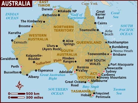
We came to Australia with three must-see destinations in mind: the Great Barrier Reef in northeastern Australia, Tasmania off the southern tip, and the Kimberley in the northwest corner of the continent. But visiting them all would be a challenge. The three regions span thousands of ocean miles: Tasmania and the Kimberley are at diagonally opposite corners of the continent, about 3,500 miles ocean miles apart. Weather and other constraints also dictated when we could be in each location.
The Australian cyclone season is in the Southern Hemisphere summer, from the first day of December to the last day of March. Both the Great Barrier Reef and the Kimberley are in the cyclone zone, so we’d not want to be there during those months. Summer also was the best time to visit high-latitude Tasmania. And the best time to visit the Kimberley was in May, just after the rainy season, when the waterfalls would be at their peak. We also had two multi-week trips we needed to make back to the US, one in July and the other in November, so we needed a good place to leave the boat for those periods with convenient airport access. And the final constraint was an eventual crossing of the Indian Ocean, best done in May-June or September-October.
Coastal-cruising through all of these regions would take years, so we decided to treat each region similar to separate countries in the South Pacific. We’d coastal-cruise each region, but make unbroken coastal passages between them. Using this approach, we came up with an itinerary that would meet all our goals.
We planned to travel from New Zealand to Australia in May, the best time to cross the Tasman Sea. The first stage would the Brisbane area, where we’d cruise locally and fly back to the US in July. On returning to Australia, we’d coastal cruise north to the Great Barrier Reef until October. And then, as if transitioning between islands in the South Pacific, we’d make the 1,000-mile passage south to the Sydney area as a single, unbroken run. We’d fly back to the US from there in November, then spend December in Sydney and get a bonus of watching the Sydney-Hobart race start and the New Year’s Eve fireworks. From Sydney we’d make a 500-mile passage south to cruise Tasmania in the summer from January through February of 2015. We’d then make a 1,500-mile passage north to return to the Great Barrier Reef after the cyclone season ended in March, and pick up where we’d left off. We’d coastal-cruise north through the Great Barrier Reef, and then make a 1,200-mile coastal passage west across the top of Australia to arrive in the Kimberley in late May/early June. After cruising the eastern Kimberley for 4-6 weeks, we’d travel east to nearby Darwin in July to fly back to the US. On returning to Australia, we’d continue south to cruise the western Kimberley in August and plan to cross the Indian Ocean in September-October.
This itinerary is one of the reasons we made the somewhat unusual crossing from Nelson, NZ north to Brisbane, rather than the more direct route west to Sydney: we would travel the 400 miles of coast between Brisbane and Sydney twice if we landed in Brisbane and three times if we landed in Sydney. And Brisbane put us closer to the Great Barrier Reef for our initial cruise there.
We also considered traveling across the south coast of Australia from Tasmania and up the west coast of Australia to reach the Kimberley. This had an appeal of rounding Cape Leeuwin, our third of the five Great Capes. But the weather along the south coast can be nasty, and the prevailing winds switch from easterly to westerly in March. There wasn’t as much to see and do along this route either. And we’d either have to rush through the Great Barrier Reef on our first trip there, or skip large parts of it. So we opted to return north along the east coast and west across the top of Australia for nicer weather and more time in the reef.
In the ten months since we arrived in Brisbane, we’ve cruised north to the southern Great Barrier Reef and the Whitsunday Islands, and south to the Hawksebury River, Sydney Harbour, and Tasmania, with two bonus stops in Melbourne to attend the 2015 Moth World Championships and the Australian Grand Prix. We’re now back in the Whitsunday Islands, midway along the Great Barrier Reef, after a 1,532 mile run from Melbourne with a stop at the Gold Coast. We’ve travelled 5,633 miles within Australia so far, and are on schedule to reach the Kimberley as planned in late May/early June.
Below are highlights from our last few days in the Gold Coast and the run north to the Whitsundays. Click any image for a larger view, or click the position to view the location on a map. And a live map of our current route and most recent log entries always is available at http://mvdirona.com/maps.
 |
Load shedding
Position: 153 25.44, -27 58.32
240-volt automatic load-shedding was just installed on Dirona. This system first turns off the hot water heater, and then the HVAC system, prior to exceeding power-source capacity.
|
 |
Bottom clean
Position: 153 25.44, -27 58.32
Dave the Diver setting up to clean the bottom. (If you are in the Gold Coast area and need a dive, call David at 0416891132). The zincs remain in good condition, so we won’t have to change them for at least another 3-6 months. We track that in our maintenance log.
|
 |
Groceries
Position: 153 25.44, -27 58.32
Woolworths dropped off a relatively small load of groceries today, mostly items that were out-of-stock in Melbourne and some produce. Spitfire apparently can smell the kibbles in those purplish-silver bags at the back on the right–but he’s not much of a bloodhound for actually locating them.
|
 |
Christmas in March
Position: 153 25.44, -27 58.32
Many Australians celebrate “Christmas in July” as that is winter here. We got our Christmas today, when the 2.6 cubic meter pallet we’d shipped from Seattle finally arrived. We’d scheduled it to ship to Melbourne early March before we arrived there, but the longshoreman’s strike delayed the shipment in Los Angeles for over a month. The pallet arrived into Melbourne last week and was delivered to the Gold Coast today.
|
 |
Inflatable fenders
Position: 153 25.44, -27 58.32
One of the items in our pallet was new Prostock Marine inflatable fenders–6 of the 18×42 and 2 of the 24×42 sizes. We’d been fighting seam leaks in our Aere inflatable fenders since they were new. Several other boat owners who had similar poor experience with Aere recommended ProStock. Prostock seams are welded rather than glued and consequently don’t have the persistent seam leaks that the Aeres often suffer from. It’s wonderful having big fenders that actually hold air again.
|
 |
Micro-tender II
Position: 153 25.46, -27 58.42
Our micro-tender is invaluable. We’ve used it throughout the South Pacific for surf landings or carrying it across the reefs. And we’ve used it extensively in New Zealand and Australia–for both surf landings and long shallow beaches where we’d not be able to land the large tender ashore. We can deploy and stow it quickly, and we can easily carry the dinghy and the motor between us, and then tie it ashore out of the tide’s reach. As an experiment, we’d gone with as small as possible when we bought it: a Mercury 6 ft 7 in. It was a little on the small side, a bit of a wet ride, and wasn’t very stable, both initially and directionally. So when Defender put the next larger size on sale for $695 we couldn’t say no. We already were in the final stages of planning a large sea freight shipment to get our fenders and other assorted parts and supplies, so shipping the dinghy was effectively for free. The new dinghy is 7 ft 10 in, stows in the same place in our lazarette, has much more interior space, is a dryer ride and is more stable in both dimensions. We love it.
|
 |
Tight quarters
Position: 153 25.46, -27 58.42
Palm Cat barely squeezed past us on the way to the Southport Yacht Club fuel dock. We’d originally planned to leave April 2nd, but Southport was able to find another slip where we could stay into the busy Easter Holiday weekend. So Dirona now is on the end of the superyacht dock.
|
 |
Inflatable fenders
Position: 153 25.46, -27 58.42
Our new Prostock Marine inflatable fenders in action. They don’t look nearly as large when deployed as when piled in the cockpit.
|
 |
Superted V
Position: 153 25.33, -27 57.11
Jean and Matt Findlay on Superted V arrived into Marine Stadium last night and we stopped by for a visit before they continued north the following day. We’ve not seen them since January at Kettering in southern Tasmania–it was great to see them again and catch up.
|
 |
Thirsty Thursday
Position: 153 25.60, -27 58.42
Greg Turner of Maritime Safety Queensland dropped by to tour the boat last week. Before leaving, he invited us to “Thirsty Thursday” at the Southport Yacht Club. It sounded like fun, so here we are. Jennifer is on Greg’s right and his partner Cyndy is on his left.
|
 |
Dirona
Position: 153 25.48, -27 58.45
To stay a little longer at the Southport Yacht Club, we moved to another berth. So we get all new scenery.
|
 |
Groceries
Position: 153 25.46, -27 58.41
Jennifer biked over to the Australia Fair Woolworths, on the other side of the waterway, to stock up on fresh produce for the trip north.
|
 |
Refueling
Position: 153 25.46, -27 58.22
We stopped off at Mariners Cove fuel station to top off our diesel and gas tanks for the trip up to the Great Barrier Reef. We carry 48 gallons of gasoline in two tanks mounted on the boat deck.
|
 |
Surfers Paradise
Position: 153 25.24, -27 57.23
A last look back at the Surfers Paradise skyline. The weather looks excellent for a 3-day run to the Whitsunday Islands to pick up where we left off. We’re expecting winds no more than 10-15 knots and swell less than a meter the whole way there.
|
 |
Gold Coast Seaway
Position: 153 25.55, -27 56.16
On calm days, the Gold Coast Seaway is very busy. In the picture you can see two surfers swimming across and the wake of a passing boat between us and them. We’re amazed surfers are willing to take on the the heavy and often fast-moving boat traffic through the seaway.
|
 |
Traffic
Position: 153 25.99, -25 18.25
As we continue our run north to the Great Barrier Reef, conditions have been good so far with light wind and swell. At times, a 1-2-knot counter-current has slowed us down a bit, but in these conditions who can complain? The Fraser Island area was unusually busy with a mix of recreational and commercial fishers. The icons on the radar display are ARPA (Automatic Radar Plotting Aid) targets that represent other boats in the area.
|
 |
Dinner
Position: 153 18.87, -24 34.71
Making “Stir-Fried Chicken with Dried Red Peppers” for dinner from Chinese Cuisine (Wei-Chuans Cookbook). We’ve had many good meals over the years from our 1974 edition of this cookbook, purchased in Toronto in the 1980s.
|
 |
Sunset
Position: 153 17.35, -24 31.87
Conditions have remained calm, with winds mostly below 10 and seas under a meter. We’re still seeing 1-2 knots of counter-current, but expect that to start dissipating soon.
|
 |
Lunch
Position: 151 48.82, -22 49.39
Sliced turkey wraps for lunch.
|
 |
Jules Verne
Position: 151 36.64, -22 37.06
The container ship Jules Verne running south for Brisbane.
|
 |
Back in the Barrier
Position: 151 17.08, -22 19.47
We’re back in the Great Barrier Reef. In the six months since we last were here, we’ve completed our southeast Australia cruise of the Hawksebury River, Sydney Harbour, Tasmania and Melbourne
|
 |
Water leak
Position: 149 37.57, -20 57.93
Boating makes available some of the most amazing experiences from all over the world. One of the least amazing ones occurred this morning where Jennifer woke up to a wet bed and carpet, with water running in from above. Fortunately it was fresh water. Not enough water was missing from the freshwater tank for that to be the problem and it wasn’t raining, so that wasn’t the problem either. It was fairly easy to isolate the leak to the pilot house air conditioning system condensate drain. Easy ended about there. Unplugging the drain, getting it flowing better, and cleaning up the mess took a bit more time. In the bottom of the photo, we’ve opened the master stateroom floor to expose the manifold where all the A/C hoses drain into the grey water tank, and are clearing the hoses with compressed air.
|
 |
90.1 degrees
Position: 149 16.64, -20 43.03
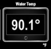
The water temperature has been increasing steadily as we work north and is now at 90.1 degrees. That’s the warmest sea water we’ve operated in.
|
 |
Click the travel log icon on the left to see these locations on a map, with the complete log of our cruise from Melbourne to the Whitsundays.
On the map page, clicking on a camera or text icon will display a picture and/or log entry for that location, and clicking on the smaller icons along the route will display latitude, longitude and other navigation data for that location. And a live map of our current route and most recent log entries always is available at http://mvdirona.com/maps. |

Pretty cool, just came across an article (somewhat old) that said you guys have moved out to sea. Going to take me a while to get through the blog. Happy journeys.
Hey Steve. It’s good to hear from you. We did move onto a boat a bit more than 6 years back but I wouldn’t see we moved out to sea :-). We’re kind of moving all over the place but our current “home” is the Great Barrier Reef in Australia.