
The most direct route from the Azores to the US is an 1,800-mile great circle route to Bermuda (the red dashed line above), then a 600-800-mile run to the US, depending on our landing choice. The problem with that routing is that the winds predominately blow from the west, on the bow, and we would often be in the path of the the storm systems that regularly move northeast across the Atlantic from the the US east coast. We’d be making the passage at the same time of year as our crossing from Newport, RI to Kinsale, Ireland and have first-hand experience on what those systems are like. And on that crossing we were running with the wind and waves. This time we’d be running against them, so we have even more reason to avoid those systems.
We instead plotted a much more southerly course through the Azores High (also called the Bermuda High), a large semi-permanent high pressure system in the Atlantic typically situated between the Azores and the Caribbean. This routing would add several hundred miles to the trip, so we’d be at sea much longer and without a break by stopping in Bermuda. But it would be worth the extra distance to avoid potentially dangerous conditions further north.
We initially had planned to spend three nights in Horta, but a passing weather system cleared faster that expected, so we departed after only two nights. The first week on our passage to Charleston, SC was through wonderfully calm conditions in the Azores High, well south of several low pressure systems moving across the Atlantic north of Bermuda. During this time, we crossed 12,000 hours on our ultra-reliable John Deere 6068AFM75 main engine; passed through the Sargasso Sea, the only sea without a land boundary; drained the 360 gallons from our forward deck bladder; and investigated a couple of boat issues, including a NMEA bus problem and a plugged HVAC drain.
Below are highlights from May 8th through 14th, 2021. Click any image for a larger view, or click the position to view the location on a map. And a live map of our current route and most recent log entries always is available at mvdirona.com/maps.
 |
Camera Failure
Position: 38°31.82’N, -28°37.31’W
We had a great walk around Horta yesterday and really enjoyed looking around and taking pictures, but it was raining pretty hard. The camera has seen a hard rain before, but this one was the end of it. Here we giving it a few days to thoroughly dry out, but it looks like it’s not coming back.
|
 |
Delcio Silva
Position: 38°31.82’N, -28°37.31’W
Delcio Silva of Bensaude Shipping Agents picking up our passports and arrival paperwork to clear us out of Horta. We were planning to depart tomorrow morning, but the weather improved enough that we could leave this morning. We would have loved to stopped for a week or more in Horta, but James needs to spend some time at work in Seattle.
We used agents frequently in the South Pacific, but haven’t for the past few years. For Horta we worked with Bensaude on the recommendation of Laurie and Alec Thyrre of Nordhavn 64 Gratitude. We’re really glad we did, as they were able to arrange a berth, dockside fueling, COVID testing and clearing in and out with great efficiency at a reasonable price. This was particularly important given our short two-night stay, allowing us time to explore the Horta area. |
 |
Horta
Position: 38°31.71’N, -28°37.04’W
A final view to Horta as we set off for Charleston.
|
 |
Monte da Guia
Position: 38°30.91’N, -28°37.09’W
The exposed ocean side of the peninsula Monte da Guia is full of sea caves.
|
 |
Capelinhos
Position: 38°30.91’N, -28°37.09’W
View to Capelinhos on the northwest corner of the island of Faial. The active volcano last erupted in 1958, destroying 3,000 homes and resulting in the evacuation and subsequent emigration of 2,000 residents.
|
 |
Route
Position: 38°27.77’N, -28°39.29’W
Our current route from Horta to Charleston, highlighted in red at the bottom of the screenshot, through the Azores High. This route is longer than the more direct Great Circle route via Bermuda (the second pink line from the top leading from the boat position), but will hopefully keep us out of the path of the steady sequence of low pressure systems that move east across the Atlantic, such as the one hitting Ireland right now.
We’ll be making the passage at about the same time of year as our crossing from Newport, RI to Kinsale, Ireland and have first-hand experience on what those systems are like. And on that crossing we were running with the wind and waves. This time we’d be running against them, so we have even more reason to avoid them. |
 |
Cleaning Deck
Position: 38°8.87’N, -28°57.25’W
After a long run, we run the boat briefly at high RPM to blow out any soot from the stack. We’d forgotten to do this on arrival into Horta, and yesterday’s fairly heavy rain probaly washed the inside of the stack down a bit, so it sooted on startup this morning. Normally the soot can be sprayed off fairly easily with water, but we didn’t notice and tracked it across the deck, so now it needs a scrub. Here we are just finishing scrubbing down the boat deck and the bow. They were due for a clean anyway, so overall it’s forward progress.
|
 |
Azores High
Position: 37°13.91’N, -30°5.91’W
We’re constructing a route using PredictWind to run south through the Azores High, that blue section of low winds near the bottom of the screenshot. The green paddle is our current location and the white boat icon is where we’ll be in a couple of days. We’re doing this, rather than follow the more direct Great Circle route to Bermuda, to minimize our exposure to the storm systems in the typically active North Atlantic. Two rather large systems currently are visible to our north.
|
 |
Conditions
Position: 37°11.18’N, -30°9.06’W
The seas are still a little active following the system that passed through yesterday, but we expect them to settle. We’re pitching 7.8° and rolling 8.3° (bottom left) with northwest winds to 11 knots on the beam. The waves mostly are on our stern, so this isn’t uncomfortable.
|
 |
Ship
Position: 37°7.98’N, -30°12.76’W
Our first ship sighting of the day 24 hours out of Horta.
|
 |
Model Bug
Position: 36°55.61’N, -30°27.06’W
Today’s NOAA Wave Watch III weather model that we pull down through our chartplotter, TimeZero, showed the entire Atlantic covered in 50kt winds ten days out. We expected this was a model bug, as the wave height was only five feet, and the anomaly disappeared in the next download.
|
 |
N2K Bus Errors
Position: 36°31.18’N, -30°50.83’W
This morning we lost heading on our SC30 satellite compass and switched over to a backup. This magnetic-based heading sensor is no nearly as precise as the satellite compass. And, since it was last used and calibrated in Australia, it’s not currently well-calibrated. We do have a spare SC30, but the first thing to check is N2k bus health. We put a Maretron N2kMeter on the bus and found 450 errors per second, where there really shouldn’t be any at all. This tells us we have a bad device or a connection problem somewhere in the NMEA bus. We’ve only seen this once before, but it’s usually fairly easy to chase down by splitting the bus and checking for errors to find the bad device or section.
|
 |
Monitoring Bus
Position: 36°26.28’N, -30°56.15’W
Jennifer at the helm monitoring N2k bus errors while James is down below disconnecting devices from the bus to troubleshoot the errors. We’re wearing our Sena Expand headsets to communicate.
|
 |
N2K Junction
Position: 36°30.56’N, -30°51.56’W
We isolated the N2k bus problem to one of the 5 or 10 devices near the back of the boat. When they’re disconnected, everything is back to working perfectly and there are no errors on the bus. As a last check, we hooked everything back up again and there were still no errors on the bus, which is to say there is some transient error towards the rear of the boat that was either corrected by the prolonged disconnection, or more likely, will return.
|
 |
Spitfire
Position: 36°22.03’N, -31°1.30’W
Spitfire enjoying the calm seas in the Azores High.
|
 |
Lowering Flag
Position: 36°20.52’N, -31°3.13’W
Lowering our Portuguese courtesy flag as we exit their waters.
|
 |
Calm Seas
Position: 36°14.15’N, -31°11.68’W
Wonderfully calm seas as we cruise through the Azores High. This should last for several days.
|
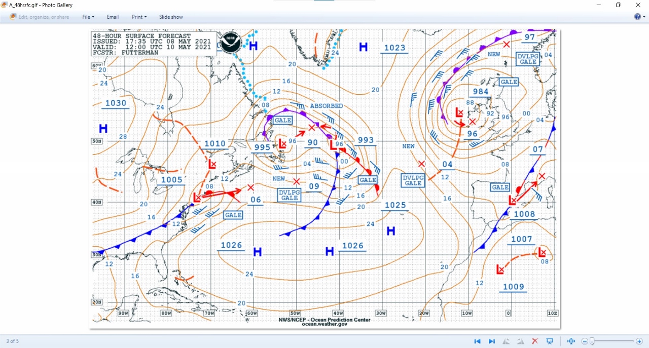 |
Low Pressure Systems
Position: 36°12.56’N, -31°13.64’W
This NOAA surface analysis chart shows several low pressure systems forming in the Atlantic north of Bermuda. We’re happy to be further south in the Azores High. The Azores are the small dots directly below the 1025 at bottom right and we’re about where the H is to the southwest.
|
 |
Flavin
Position: 35°56.07’N, -31°32.89’W
The tanker Flavin about eight miles away heading from Corpus Christi, Texas to Antwerp.
|
 |
Dolphins
Position: 35°55.62’N, -31°33.51’W
A large pod of dolphins chasing our bow late in the afternoon.
|
 |
12,000 Hours
Position: 35°19.93’N, -32°16.12’W
We just reached 12,000 hours on our John Deere 6068AFM75 main engine. Our Deere has never failed to start and, more importantly, it’s never stopped when we were using it. Nothing makes you respect an engine more than being 1,000 nautical miles off shore in a single-engine boat. This engine has been simply amazing.
|
 |
Current
Position: 35°4.00’N, -32°34.26’W
We are fighting some negative current and making only 5.7 knots. You can see by the green course line that the autopilot is trying to steer us more south to conteract the current pushing us north.
|
 |
UTC -0300
Position: 34°57.75’N, -32°41.42’W
We just put the clocks back another two hours to UTC -03:00 (in Greenland daylight savings time). We;ll make one more two-hour adjustment as we get closer to the Eastern time zone in the US.
|
 |
Calm
Position: 34°56.59’N, -32°42.72’W
Conditions remain wonderfully calm, with below 5 knots (upper right) and pitch and roll 4.7° and 6.7°. respectively (lower left).
|
 |
Trapped Bird
Position: 34°52.28’N, -32°47.66’W
We found this large seabird trapped in the port walkway beside the pilot house today. The walkway is so deep and narrow that it can’t fly away, and it was unable to jump up the steep stairs to the boat deck. We helped it up the stairs, gave it more “runway space” and it took off and flew away just fine.
|
 |
Temperatures
Position: 34°3.90’N, -33°38.87’W
The temperatures are rising—the water (lower left) is 73.7°F (23° C) and the air (middle) is 70.1° (21° C).
|
 |
Seaweed
Position: 33°52.52’N, -33°58.83’W
Large clumps of this gold-colored seaweed cover the water surface as we proceed.
|
 |
Almost Eighty
Position: 33°51.73’N, -34°1.87’W
The 144ft (44m) superyacht Almost Eighty en route to Gibraltar.
|
 |
Right Turn
Position: 33°57.17’N, -33°45.73’W
We’re well within the Azores High now, about the latitude of Bermuda, and have turned west to proceed to Charleston.
|
 |
Fuel Bladder
Position: 33°51.38’N, -34°3.26’W
The key with ensuring that fuel bladders don’t shift underway is to have them very full so fuel can’t slosh around in them. Here James is demonstrating how full ours are by standing on one and not sinking in at all. They are very full. We left Dublin, into 25-30 knots of wind and fairly large swell and, even in rough water, the bladders hardly show a ripple, looking almost like rigid tanks.
The is the seventh time we’ve used two 300-gallon standard ATL deck fuel bladders and they still are in great shape. We’re really impressed with the quality and longevity of the ATL bladders. |
 |
Sunset
Position: 33°48.40’N, -34°14.74’W
Beautiful sunset at sea on our second night out from Horta.
|
 |
MSR HVAC
Position: 33°18.07’N, -36°1.69’W
We found freshwater in the bilge this morning. On investigation, we also found freshwater in the bilge underneath the master stateroom and traced it down to the HVAC in the master stateroom. The condensate tray was not draining and overflowing.
|
 |
HVAC Drain Manifold
Position: 33°17.45’N, -36°3.61’W
Here we have the bilge at the foot of the master stateroom berth open to investigate the HVAC drain manifold at bottom right that carries the HVAC condensation into the grey water tank. Between the tank and the manifold we have a white Hepvo valve (upper left) to prevent grey water tank odors from reaching the house.
|
 |
Flying Fish
Position: 33°15.72’N, -36°9.02’W
Jennifer was on the bow checking for good venting from the grey water tank and found this flying fish. We’re wearing our Sena Expand headsets to communicate. They’re really working out well.
|
 |
Sludge
Position: 33°16.90’N, -36°5.34’W
The Hepvo valve works well and has been in place since the boat was new. But we haven’t used the HVAC for several years and the valve was plugged with a thick sludge. You can see pieces of it in the sink.
|
 |
New Hepvo Valve
Position: 33°16.62’N, -36°6.20’W
The old Hepvo valve wasn’t in great shape after a decade, so we decided to just replace it with a spare. We have these installed on all drains into the greywater tank and were expecting these to be a fragile part, so have several spares. But this is perhaps the second one we’ve replaced—they’ve lasted surprisingly well.
|
 |
Conditions
Position: 33°7.14’N, -36°35.56’W
Conditions remain excellent in the Azores High, with winds (upper right) less than 5 knots and pitch and roll (lower left) 6.1° and 4.5° respectively. We;re doing 7.1 knots (middle left) at 1.19 nm/gallon (middle right).
|
 |
Gas Gala
Position: 32°49.69’N, -37°18.47’W
The tanker Gas Gala en route to the Suez Canal.
|
 |
Weather Models
Position: 32°49.17’N, -37°19.71’W
We’ve got a large storm system coming that will push the Azores High down and extend into our path. The system still is quite unpredictable and the models really vary as to the route to follow for best conditions. Each colored line represents a route based on the weather models listed at the bottom left of the PredistWind screenshot. The model we’ve mostly been using, ECMWF, is the black line that extends way up north. We’re not keen in heading far north at this point, given that would put us in the path of subsequent systems, so plan to keep heading west at roughly this latitude and see how things develop.
|
 |
Conditions
Position: 32°28.10’N, -38°10.52’W
Conditions remain excellent, with less than 5 knots of wind (upper right) and 3.4° of pitch and 4.4°l of roll (lower left).
|
 |
Seaweed
Position: 32°16.84’N, -38°37.29’W
We’ve been seeing more and more of this gold-colored seaweed covering the water surface in huge swaths.
Update 05/21: We’ve since learned this is the Sargasso Sea, the only sea without a land boundary. |
 |
Spitfire
Position: 32°7.97’N, -39°0.54’W
Spitfire dozing in his new favourite sleeping location, tucked in between two pillows in the corner of the pilot house off-watch berth.
|
 |
Draining Bladder
Position: 32°2.97’N, -39°18.06’W
We’ve consumed enough fuel now that we can drain the 360-gallon forward bladder. Here we have a fuel hose attached and are pumping it through a filter and into the main tanks (see Fuel for the Crossing for details on this system). We can pump about 100 gallons per hour, so this 360-gallon tank will pump down in about 3.5 hours.
|
 |
PH HVAC
Position: 32°2.65’N, -39°19.19’W
Since we had a drain blockage with the stateroom HVAC systems, and haven’t used the pilot house air conditioning for a while either, we checked to ensure it was draining properly. No problems there.
|
 |
Primary Fuel Filter
Position: 31°59.93’N, -39°30.82’W
Changing the main engine primary fuel filter. This one went 465 hours, which is a fairly typical interval for it. The old filter is black, indicating asphaltenes are building up in the fuel tank. But with fuel filter life as good as it is, even in rough water, the tanks still are in pretty good shape.
|
 |
Nearly Done
Position: 32°0.06’N, -39°33.60’W
Tipping up the forward bladder to move the fuel down to the drain outlet to pull as much fuel as possible out of it prior to cleaning and storage.
|
 |
Scrubbing
Position: 32°0.33’N, -39°38.82’W
Giving the forward bladder a scrub before drying and stowing it.
|
 |
Position: 32°4.36’N, -40°8.83’W
The cargo ship Navios Utmost en route from Freeport, Bahamas to the Suez Canal.
|
 |
Sunset
Position: 32°5.38’N, -40°14.69’W
Sunset over calm seas on our fourth night out from Horta.
|
 |
Patris
Position: 32°13.23’N, -40°59.94’W
The tanker Patris five miles to our south heading east to Sines, Portugal.
|
 |
Weather System
Position: 32°18.58’N, -41°30.84’W
The weather routes continue to diverge as the the best route to take with the upcoming weather system using PredictWind’s comfort (as opposed to fastest) setting. The green paddle at right is our current location, the white boat icon is where we will be in four days following the ECMWF model, and the white dots are where we would be on the each of the other models. Both ECMWF and SPIRE, considered the most accurate models, indicate we should head directly west and the the system will pass to our north.
|
 |
Kiwi Fruit
Position: 32°19.27’N, -41°34.74’W
Fresh kiwi fruit with our breakfast this morning.
|
 |
Weather Data
Position: 32°9.44’N, -42°23.28’W
The PredictWind weather data shows we’re in for about 24 hours of rough weather in 3-4 days. In the screenshot, we’ve imported the data into a spreadsheet and colorized three columns. The first column is wave height, and is colored green if the waves are less than 4 feet or the wave period is more than 1.3 times the height, orange if the wave height is less than 7 feet or the period is 1-1.3 times the height, and red for everything else. The second column is wave direction, colored green if the waves are coming from the direction of 50° on either side of the stern, red for 50° on either side of the bow, and orange otherwise. The final column is wave period divided by height and is colored the same as for wave height, but only using the wave period part of the formula.
|
 |
Sunset
Position: 31°58.62’N, -43°32.47’W
Fabulous sunset on our sixth day out from Horta.
|
 |
Popcorn
Position: 31°53.55’N, -44°22.73’W
Air-popped popcorn makes a great midnight watch snack.
|
 |
Miss Pezi
Position: 31°52.35’N, -44°47.74’W
The 65ft (20 m) pleasure craft Miss Pezi passing 3.5 miles to our south en route for Delgada, Portugal. The metal-hulled vessel is built in a style similar to the Nordhavn 62.
|
 |
Spitfire
Position: 31°44.55’N, -46°11.72’W
Spitfire doing what he does best (or at least what he does most) on passage: sleeping in the offwatch berth.
|
 |
Pork Tacos
Position: 31°43.70’N, -46°20.92’W
Pork tacos for dinner.
|
 |
Click the travel log icon on the left to see these locations on a map, with the complete log of our cruise.
On the map page, clicking on a camera or text icon will display a picture and/or log entry for that location, and clicking on the smaller icons along the route will display latitude, longitude and other navigation data for that location. And a live map of our current route and most recent log entries always is available at mvdirona.com/maps. |
Although I have enjoyed reading about your intensely thorough exploration of Norwegian cruising grounds and long stay off Scotland, it’s nice to read your passage-making trans-Atlantic post. Dirona is so suited to ocean voyaging it is interesting to read how you and Dirona handle a long passage.
Thanks for the feedback on the blog. This trip has felt like a long one and we’re ready to arrive but no complaints at all. Conditions are good and it looks we’ll have a smooth tail end to this trip.