From Lake Pihlajavesi we ran 71 miles back to Lappeenranta, overnighting partway along. We’d gone through almost all the gasoline we bought in Nynashamn back in April, so stopped off at Puumala to fill our gas tanks for the tender and top up our diesel.
At Lappeenranta we found a surprisingly secluded anchorage just north of town to stage for a departure through the Saimaa Canal the following morning. After a final visit to Lappeenranta for lunch, we ran the tender a short distance into the Saimaa Canal for a different perspective.
Below are trip highlights from June 17th and 18th, 2019 en route to and in Lappeenranta, Finland. Click any image for a larger view, or click the position to view the location on a map. And a live map of our current route and most recent log entries always is available at mvdirona.com/maps.
 |
Lake Scenery
Position: 61°44.89’N, 28°54.81’E
More beautiful lake scenery and clear calm weather as we head south towards Puumala.
|
 |
Spitfire
Position: 61°42.45’N, 28°45.01’E
We’ve all been enjoying the calm and beautiful lake cruising, but Spitfire seems particularly happy here. He’s out on the bow most mornings as we’re underway.
|
 |
Lehtosaari
Position: 61°41.73’N, 28°31.58’E
Light on the island of Lehtosaari.
|
 |
Nestori
Position: 61°36.39’N, 28°23.52’E
The 492ft (150m) ferry Nestori, operating just north of Puumala, is one of the biggest ferries operating within Finland with a carrying capacity of 150 tons. It’s surprising that this is one of the biggest, as it doesn’t look all that large, but on reflection we’ve not seen any larger operating locally.
|
 |
Puumala
Position: 61°31.31’N, 28°10.49’E
On the fuel dock at Puumala to fill up our two 29-gallon (110L) gasoline tanks. We’ve gone through almost all the gasoline we bought in Nynashamn back in April.
|
 |
Fueling
Position: 61°31.31’N, 28°10.49’E
Since we were on the dock anyway, we took on 133 gallons (503L) of diesel to top up our tanks since our truck delivery in Savonlinna only had 5,000L and we needed slightly more.
|
 |
Logs
Position: 61°27.84’N, 28°4.52’E
A load of logs being transferred to a barge a few miles south of Puumala.
|
 |
Hemppa
Position: 61°8.33’N, 28°20.66’E
Following the converted-to-pleasure craft tug Hemmpa towards Lappeenranta.
|
 |
SS Suvi-Saimaa
Position: 61°3.75’N, 28°11.22’E
We found a surprisingly secluded anchorage just north of Lappeenranta and ran the tender into town for lunch. We had a fun lunch on the deck of the SS Suvi-Saimaa, an old inland steamship converted to a restaurant. Behind Jennifer is the Prinsessa Armaada, where we had lunch last time we were here.
|
 |
Slide
Position: 61°4.01’N, 28°11.83’E
It’s summer in the lakes and the water park with its slides and diving boards is popular. We didn’t see anyone there two weeks ago.
|
 |
Bonfire
Position: 61°4.56’N, 28°14.77’E
Another bonfire ready to go for Midsummer Eve off the lumber mill. We thought it was a little crazy to have a bonfire right in front of all those logs stacked ashore, but it’s on a float so presumably will be towed well away before being lit.
|
 |
Logs
Position: 61°4.59’N, 28°14.78’E
We watched with interest as a man drove up in this truck, jumped in the red cab that then lifted up on hydraulics, then proceeded to rapidly transfer a massive pile of logs from shore onto his two trailers.
|
 |
Saimaa Canal
Position: 61°4.57’N, 28°17.64’E
We ran the tender a short distance along the Saimaa Canal for a different perspective. This is looking north from a portion of the original canal, leftover from when the canal was widened and straightened in the 1960s.
|
 |
Train
Position: 61°4.62’N, 28°17.59’E
Train passing over a railway bridge along the Saimaa Canal, with a new bridge under construction in the foreground. The train crept unusually slowly over the bridge, perhaps due to it being in poor condition and requiring replacement.
|
 |
Gate
Position: 61°4.77’N, 28°17.13’E
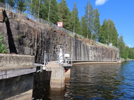
When we’d passed these structures alongside the canal in Dirona, we’d guessed they were some kind of overflow system. But on closer inspection in the tender we realized they were large gates that could be swung into place for canal maintenance.
|
 |
Tugs
Position: 61°5.01’N, 28°17.61’E
A fleet of converted tugs at Kanavansuun just east of the Saimaa Canal entrance to the lakes.
|
 |
Click the travel log icon on the left to see these locations on a map, with the complete log of our cruise.
On the map page, clicking on a camera or text icon will display a picture and/or log entry for that location, and clicking on the smaller icons along the route will display latitude, longitude and other navigation data for that location. And a live map of our current route and most recent log entries always is available at mvdirona.com/maps. |

Dear Jennifer, dear James
I’m reading through your blog since I try to get all information and impressions about Nordhavn boats. I’m in negotiation for a N47 (Spirit of Freindship, Bari). So fingers cross – and who know if we will meetin in the future.
In case you fisit Finland again – just take a break from the boat and stay at my holiday house – in one of the most beutiful areas for lake Saaima.
Also in winter time its just amazing. Here some impressions:
https://youtu.be/UUryOC6hSiQ
We would love to visit Lake Saaima in the winter. It was spectacular in the summer and the winter looks wonderful as well. We’ll have to do a trip.
Good luck on getting the Nordhavn 47. They are a great boat.