Linnansaari National Park on Lake Haukivesi encompasses 15 sq miles (38 sq km) of beautiful Saimaa Lakes scenery. Established in 1956 to protect the natural landscape of the Finnish lakeland, the park also is a habitat for the critically endangered Saimaa Ringed Seal.
After a 68-mile run from Puumala through fabulous lake scenery, we anchored for two peaceful nights at Linnansaari. While there, we did a 41-mile tender exploration through the area, touring the park, the Oravi and Haponlahti canals, and the striking Resort Jarvisydan at Porosalmi.
Below are trip highlights from June 5th and 6th en route to and in Linnansaari National Park, Finland. Click any image for a larger view, or click the position to view the location on a map. And a live map of our current route and most recent log entries always is available at mvdirona.com/maps.
 |
Puumalansalmi Bridge
Position: 61°31.48’N, 28°9.95’E
Approaching the Puumalansalmi Bridge that we’d walked across yesterday.
|
 |
Current
Position: 61°31.41’N, 28°10.07’E
The current in the lakes is surprisingly strong right now with spring melt-off still swelling the rivers that feed the lakes.
|
 |
Bluff
Position: 61°45.04’N, 28°19.10’E
Sheer bluff reflecting in still waters. The Saimaa Lake scenery is spectacular, especially on such a clear and calm day.
|
 |
Second Bridge
Position: 61°44.75’N, 28°21.35’E
Passing under the second of several bridges we’ll encounter today
|
 |
New Bridge
Position: 61°44.13’N, 28°30.13’E
Our charts showed only the cable ferry at Vekaransalmi, but no bridge. The new bridge is under construction, and parts of the waterway are blocked below, but there was still plenty of room for us to pass.
|
 |
Vankalaisenselka
Position: 61°44.34’N, 28°30.05’E
Beautiful lake Vankalaisenselka just beyond the new bridge.
|
 |
Tuohiluoto
Position: 61°47.04’N, 28°37.64’E
Lighthouse on the small island of Tuohiluoto in the Saimaa Lakes.
|
 |
Panta Rhei
Position: 61°48.69’N, 28°38.19’E
The Netherlands-flagged general cargo ship Panta Rhei en route to Amsterdam. It seems to make regular runs between Finland and the Netherlands.
|
 |
Spitfire
Position: 61°49.23’N, 28°37.02’E
Spitfire on watch as a flock of swallows repeatedly swoop and swarm the boat while we’re underway.
|
 |
Koivukanta-Haaporannanlahti
Position: 61°49.09’N, 28°43.65’E
The Koivukanta-Haaporannanlahti cable ferry. The Saimaa Lakes region has literally thousands of islands, many of which are connected by ferry.
|
 |
Varisluoto
Position: 61°49.27’N, 28°50.99’E
The Varisluoto to our east as we turn north towards Savonlinna in a scene that almost looks like a painting.
|
 |
Log Barge
Position: 61°49.55’N, 28°51.42’E
Log barge passing us heading south. Timber once accounted for 90% of all Finnish exports and logging still is a major industry in the Saimaa Lakes region.
|
 |
Pleasure Craft
Position: 61°49.75’N, 28°51.65’E
Outside Helsinki, we’ve not seen many pleasure craft underway so far in Finland. But we expect that will change soon as the short northern summer arrives.
|
 |
Olavinlinna
Position: 61°51.69’N, 28°53.51’E
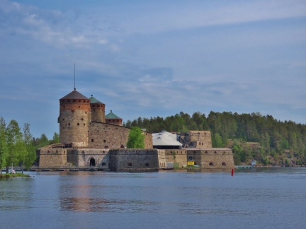
The 15-century fortress Olavinlinna at Savonlinna was built by the Swedes when they controlled Finland. We’ll be spending some time on Savonlinna on our return trip south and will tour the fortress then.
|
 |
Current
Position: 61°51.84’N, 28°54.17’E
The currents are so strong in the narrow channel around Olavinlinna that the water doesn’t freeze in the winter, protecting the castle from an over-ice enemy siege. This also makes for an exciting run past by boat.
|
 |
Kyronsalmi Railway Bridge
Position: 61°51.97’N, 28°54.17’E
We called earlier this morning to arrange a noon opening of the 7.5m Kyronsalmi railway bridge. And right on time, the bridge swung open for us to pass. The bridge is operated remotely, so we didn’t see anyone on-site.
|
 |
Kyronsalmi Road Bridge
Position: 61°52.11’N, 28°54.37’E
Our air draft is 9.2m, so we have plenty of space to pass under the 10.3m Kyronsalmi road bridge and don’t need it opened.
|
 |
Bridge Removed
Position: 61°52.93’N, 28°50.41’E
All our charts show a fixed 4.4m railway bridge across Laitatsalmi, but we couldn’t see one as we passed by to the south. We’d miss our noon opening of the railway bridge if we stopped to investigate, so we checked it out once through. And indeed the bridge has been removed. We can easily clear the 13.2m fixed road bridge, so we won’t need an opening when we return south.
|
 |
Linnansaari
Position: 62°6.18’N, 28°32.78’E
At anchor in beautiful Linnansaari National Park.
|
 |
Swimming
Position: 62°6.11’N, 28°31.12’E
The water temperature is 64°F (17.8°C) and we’re starting to see people swimming.
|
 |
Calm
Position: 62°5.87’N, 28°31.39’E
Wonderfully calm conditions looking south in Linnansaari National Park while out on a tender tour.
|
 |
Evening
Position: 62°6.22’N, 28°32.79’E
The view from our anchorage at Linnansaari National Park in Finland’s Saimaa Lakes region. It’s 8pm and the sun hardly sets now.
|
 |
Morning Drink
Position: 62°6.23’N, 28°32.78’E
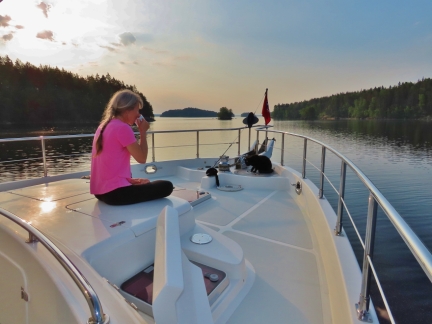
Jennifer and Spitfire having a morning drink on deck. Jennifer has a coffee and Spitfire likes to drink water that collects on deck overnight.
|
 |
Pollen
Position: 62°6.23’N, 28°32.78’E
The water, the boat and pretty much every surface has been coated in yellow pollen for the past few days.
|
 |
Tender
Position: 62°6.86’N, 28°28.39’E
The tender tied off to the small dock at the north end of Linnansaari to walk the trail there.
|
 |
Linnavuori Rock
Position: 62°6.97’N, 28°28.33’E
Great view west from Linnavuori Rock scenic lookout in Linnansaari National Park.
|
 |
Oravi Canal
Position: 62°6.58’N, 28°36.36’E
At the entrance to Oravi Canal. We’re in the tender today, but will pass through in Dirona tomorrow.
|
 |
Wall
Position: 62°6.70’N, 28°36.41’E
The Oravi Canal was built in 1861 and this section of wall could easily be that old.
|
 |
Ruukinranta
Position: 62°6.89’N, 28°36.35’E
We had lunch on the deck at Restaurant Ruukinranta overlooking the Oravi canal. Our tender is tied off rightmost in the picture, farthest from shore.
|
 |
Haponlahti Canal
Position: 62°5.89’N, 28°39.71’E
The Haponlahti Canal was completed in 1960 to provide a wider alternative to the nearby the Oravi Canal. When we ran the tender through, we spotted a dock that looked reasonably heavily used. We stopped to have a look and found a staircase up to the road for a great view from the bridge over the canal. This is looking north, with our tender just visible tied off to the dock on the right.
|
 |
Waterways
Position: 62°6.87’N, 28°19.54’E
The Saimaa Lakes region is full of thousands of islands and complex waterways that make for great exploration in the tender.
|
 |
Houseboat
Position: 62°7.18’N, 28°18.70’E
We stopped in to check out the extensive property of Resort Jarvisydan. This is one of several beautiful houseboats moored on their new-looking docks.
|
 |
Trail
Position: 62°7.27’N, 28°19.06’E
Walking the trails through the forest behind Resort Jarvisydan.
|
 |
Sauna World
Position: 62°7.17’N, 28°18.82’E
Resort Jarvisydan is huge. This is their “Sauna World”, a large, multi-floored sauna.
|
 |
Pool
Position: 62°7.16’N, 28°18.79’E
Looking across the pool at Resort Jarvisydan to their docks.
|
 |
Terrace
Position: 62°7.25’N, 28°18.70’E
Enjoying a glass of wine on the terrace at Resort Jarvisydan. The resort has been in existence since the 17th century and the current owner is the 11th generation of Heiskanen family to run the business. It’s quite an impressive facility.
|
 |
31 kts
Position: 62°6.26’N, 28°26.66’E
Running back to Dirona at 31 kts. We’re sure loving the “new” tender.
|
 |
86.4°
Position: 62°6.24’N, 28°32.80’E
The temperature has shot up to a surprising 86.4°F (30°C) today (top center). It’s hard to believe that only a month ago we had snow on the deck.
|
 |
Spitfire
Position: 62°6.24’N, 28°32.78’E
|
 |
Sheep
Position: 62°6.24’N, 28°32.79’E
While enjoying a breeze on the flybridge we heard a great rustling ashore as a herd of sheep arrived on the point.
|
 |
Click the travel log icon on the left to see these locations on a map, with the complete log of our cruise.
On the map page, clicking on a camera or text icon will display a picture and/or log entry for that location, and clicking on the smaller icons along the route will display latitude, longitude and other navigation data for that location. And a live map of our current route and most recent log entries always is available at mvdirona.com/maps. |

If your comment doesn't show up right away, send us email and we'll dredge it out of the spam filter.