We plan on getting underway this weekend for Kinsale, Ireland. It’s a tiny bit early in the season but we have what looks to be a blocking high developing in the North Atlantic which will stall the steady stream of low-pressure systems that we’ve been watching for the past several months. Unfortunately the high is strong enough it will actually produce less-than-comfortable conditions. But we’ll take uncomfortable over unsafe all day long.
We’ll take on 2,000 gallons of fuel at 10am this morning and, depending upon the speed of the low passing through the area now, we’ll get underway tonight or perhaps tomorrow morning. Our plan is proceed east below the ice line carried south by the Labrador Current and then make our way directly toward Kinsale, Ireland. We expect to take about 19 days to do the just short of 3,000 nm.
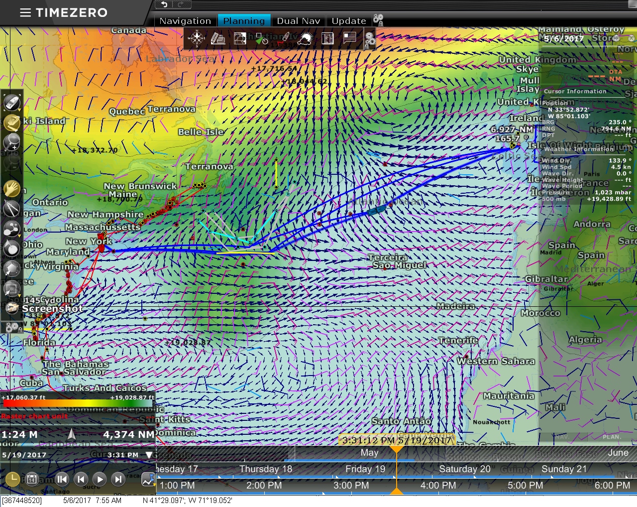
The video below shows a visualization of our planned route from Newport RI to Kinsale Ireland using our PC-based chartplotter software, TimeZero Professional. Similar to our previous video on departure planning, TimeZero plays the weather file forward and displays weather conditions as the boat progresses on the route at a given departure time and speed. In that other video, the color gradients showed wave height. This video shows the height of the 500mb level, a major influence on surface winds. Usually the height is expressed in meters, but TimeZero shows them in feet in the scale at the bottom left, ranging from 17,060ft (5,200m) in red to 19,028ft (5,800m) in blue.
According to Chen and Chesneau in Heavy Weather Avoidance and Route Planning, the safest place to be is outside the 18,700ft (5,700m) contour. In this visualization, those are the areas in green and blue. Initially we are inside that contour, but as we turn the corner south of the iceberg limit shown in turquoise, you can see a large blue area forming in the north Atlantic. This is a blocking high in the 500mb level that hopefully will keep any low pressure systems from moving onto our route. On May 21st, the weather bar at the bottom changes from orange to red as we reach the end of the available weather data, but hopefully the high will persist until we reach Ireland.
Hello. I found this video. It is a trip up to Lofoten in Norway
http://www.mby.com/videos/cruising/video-princess-v39-to-norway-part-1?pid=83982
Thanks Jan. We are planning to be in Norway in the first half of 2018 and we’re looking forward to it.
How excitied you must be – comming to the old world!!
Anyway if you if you are comming up to Scandinavia and Sweden take a look at
https://en.wikipedia.org/wiki/G%C3%B6ta_Canal . Using this canal you can pass in the middle of southern Sweden from Gothenburg on the west coast to Norrköping on the east coast. A very relaxing journey .
I have followed you around the world and I just love it.
May the high’s and low’s be with you.
Rgds LeifJ
The canal looks like fun. And, yes, we are absolutely planning to spend some time in your area. It won’t be this year but we are looking forward to it and it is part of the plan
Saw you are now on your way to cross the Atlantic. I admired the way you studied the weather charts and made your decision. Very much the way I remembered the way you advised me at Amazon. Will follow your progress. Safe crossing.
Thanks Marc. On this crossing, we accepted somewhat rougher water than usual in return for what appears to be stable conditions where, the trip as a whole is a bit rougher than ideal but it’s always safe and the conditions look stable.
Best wishes for a good crossing, and may the high hold!! Looking forward to reading about your voyage and the Kinsale area ( as we hope to be there later in the summer.
Fair Winds
Thanks Rob. Winds have settled from 25 when we left to 10 to 15 kts now.
If you do happen to be Kinsale at the same time as us, say hi!
James,
Echoing Rob’s best wishes for a safe crossing.
How’s Spitfire (him wot you are staff for) taking this current trip? With a yawn?
Thanks Alex. Spitfire is doing great. Currently sound asleep beside me upside down. Earlier in the trip he had a short go with sea sickness but he quickly go his sea legs back and the water has flattened out so he’s just loving it now.
Good luck on your crossing. We live here in Newport and have followed your blog. We’re taking our sailboat to Bras d’Or this summer so enjoyed following your trip there. We hope to follow in your wake next summer to cross from Newport to Scandinavia. We’ll be following you on your wonderful blog!!
Steve and Nancy
Newport to Scandinavia sounds exiting. Our plans after Ireland, Scotland, and England this year are to head to Norway and perhaps beyond next year. I hope our paths cross. Enjoy Bras d’Or and consider the South Coast of Newfoudland as well. The Fjords there are incredible.
19 days is a long time to hope for the high to hold out any lows and for the gribs to be accurate. Your reliance on grib files, I believe, makes good sense and I have found them to be fairly accurate out to at least ten days. Good luck and may the wind and waves stay abaft of the beam
You are 100% right Ken. Weather models can give a good perspective on weather 10 days out but really don’t help much for weather 20 in the future. That uncertainty is the reality of crossing oceans in small boats. They just don’t have the speed to stay inside the reliable forecast window. The conditions we like in this case is a strong high pressure system building in the north east Atlantic, no dangerous lows on the horizon, and we are heading out on the trailing edge of the last coastal low coming through Newport. Last night we had gusts to 38 kts. Aiming for the trailing edge of a passing coastal low means it’ll be a bit rough but it maximizes the distance we can make before the next low comes through. Further out in the Atlantic, the high pressure area will again contribute some bumpy water but has a high probability of holding off the steady stream of low pressure systems we have been watching across the North Atlantic for the last few months.