MV Dirona travel digest for Bergen and Area 2020

|
Click the travel log icon on the left to see these locations on a map,
with the complete log of our cruise. On the map page, clicking on a camera or text icon will display a picture and/or log entry for that location, and clicking on the smaller icons along the route will display latitude, longitude and other navigation data for that location. And a live map of our current route and most recent log entries always is available at //mvdirona.com/maps/LocationCurrent.html. |
 |
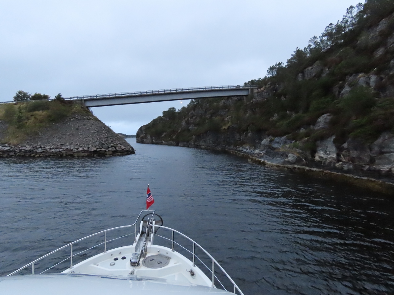
9/11/2020: Lukksund
Position: 60°3.06'N, 5°42.35'E
Looking back to the bridge across the narrow and scenic channel Lukksund as we exit the Sunnhordland district towards the Bergen area.
|
 |
9/11/2020: Rygerfonn
Position: 60°3.62'N, 5°42.49'E
The Hardangerfjordekspressen ferry Rygerfonn underway from Bergen to Rosendal.
|
 |
9/11/2020: Too Shallow
Position: 60°16.76'N, 5°40.05'E
We considered anchoring a the small bay at the head of Adlandsfjorden, where our charts showed 20ft of water. But we bailed after seeing depths of 10ft on the approach and anchored off Adlandsholmen instead.
|
 |
9/11/2020: View Home
Position: 60°16.66'N, 5°39.87'E
Beautiful modern view home along the shore of Adlandsfjorden.
|
 |
9/11/2020: Watermaker Reman
Position: 60°16.04'N, 5°38.73'E
The watermaker motor issue has gotten worse over the past few days. Today we tackled the job of servicing the very-built-in system and removing the very-built-in pump and motor. We ended up replacing the motor, which addressed the inrush issue, and also replaced the control panel and the membranes. The only major component we didn't replace was the pump itself.
Read more ... |
 |
9/11/2020: NFL
Position: 60°16.05'N, 5°38.71'E
Watching the first game of the 2020 NFL season as the Kansas City Chiefs take on the Houston Texans. It's a little odd seeing the stadiums so empty due to pandemic restrictions, but we're glad the season is running at least.
|
 |
9/11/2020: 42 Knots
Position: 60°16.04'N, 5°38.73'E
A small storm system is passing through, bringing gusty winds. We've seen 42 knots at the anchorage off Adlandsholmen.
|
 |
9/12/2020: Pump and Motor
Position: 60°16.05'N, 5°38.73'E
Yesterday afternoon we disassembled the watermaker. Today we replaced the motor and re-assembled the unit. The watermaker is now again fully operational.
|
 |
9/13/2020: Membrane Replacement
Position: 60°16.02'N, 5°38.73'E
We have a couple of maintenance items that we decided to do while the watermaker is being worked on. The system has just over 2,000 hours on it and is due for its second membrane replacement. The first set lasted about four years in heavy use and this set has gone just over six years. Given that we run 175-200 hours per year, this feels like excellent membrane life.
The other issue is a small one that doesn't affect the operation of the system. About six years ago, the NVRAM that stores the last maintenance interval became corrupt and so it frequently flashes the "service required" light. This doesn't affect the system in any way, but since we're there, we might as well repair that as well. |
 |
9/13/2020: Flushing Membranes
Position: 60°16.02'N, 5°38.72'E
When membranes are replaced, they water maker needs to be run for an hour, discarding the water, to ensure it's clean and safe for human consumption. We connected a garden house to the water maker output to run the first hour of product water overboard. It's nice to see the system running well and producing a bit more than 25 gallons per hour.
|
 |
9/13/2020: Happy Hour
Position: 60°16.03'N, 5°38.71'E
Conditions calmed considerably in the anchorage at Adlandsholmen today, so we enjoyed a well-deserved Happy Hour on the back deck after completing the watermaker reman.
|
 |
9/14/2020: 86 PPM
Position: 60°13.27'N, 5°35.42'E
It's wonderful to seeing the watermaker producing freshwater at 86 PPM (parts per million of total disolved solids). Before changing the membranes, we were only able to produce water in the 650 PPM range. (Seawater starts at about 30,000 PPM and, according to the Safe Drinking Water Foundation, less than 600 PPM is good quality and less than 300 is excellent). We probably could have run these membranes another 6-12 months, but since we were in there servicing it, we decided to change them.
|
 |
9/14/2020: Private Islands
Position: 60°14.40'N, 5°11.65'E
The channel Bukkasundet south of Bergen is full of tiny islands, each with a private home. What a nice setup.
|
 |
9/14/2020: Airplane
Position: 60°16.45'N, 5°11.39'E
Occasionally we pickup an airplane on AIS, showing an airplane symbol. This one is taking off from nearby Bergen airport at 82 kts (94 mph, 151 kph).
|
 |
9/14/2020: Askoy Bridge
Position: 60°23.44'N, 5°12.24'E
About to pass under the Askoy Bridge just outside Bergen. When completed in 1992, its main span of 2,789 ft (850 m) was the longest suspension bridge in Norway. It was superseded in 2013 by the Hardanger tunnel-to-tunnel bridge that we passed over and under in Hardangerfjord, with a main span of 4,300 ft (1,310 m).
|
 |
9/14/2020: KL Sandefjord
Position: 60°23.84'N, 5°13.70'E
The anchor handling tug supply vessel KL Sandefjord holding station just west of Bergen. When launched in 2011, the manufacturer claimed it had the largest bollard pull in the world of 390 tons.
|
 |
9/14/2020: View Home
Position: 60°28.69'N, 5°15.15'E
One of the many beautiful, modern view homes just outside Bergen.
|
 |
9/14/2020: Tyrving
Position: 60°30.62'N, 5°15.30'E
The fast ferry Tyrving roaring south from Bergen harbour.
|
 |
9/14/2020: Waterfall
Position: 60°31.83'N, 5°15.04'E
The past few days of rain have really brought out the waterfalls. This one is flowing into the south end of the waterway Krossnessundet as we approach the island of Flatoy.
|
 |
9/14/2020: Tronds Lift 8
Position: 60°32.05'N, 5°14.94'E
Tronds Lift 8 at the island of Flatoy, one of several Tronds Marine cranes we've seen during our times in Norway. The crane has a lifting capacity of 400MT.
|
 |
9/15/2020: Flatoy
Position: 60°32.65'N, 5°15.02'E
Morning view to the sheltered anchorage off the island of Flatoy. It's a popular place at the height of the season, but we had it all to ourselves mid-September.
|
 |
9/15/2020: Nordhordland Bridge
Position: 60°31.42'N, 5°15.41'E
About to pass under the Nordhordland Bridge, a combination cable-stayed and pontoon bridge. Completed in 1994, it is the second longest bridge in Norway and the country's second pontoon bridge.
|
 |
9/15/2020: Nordhavn Ad
Position: 60°31.67'N, 5°17.68'E
Dirona was featured in the Nordhavn ad on the back cover of the latest issue of Power & Motoryacht magazine. Thanks to blog reader Torbjorn Curtsson and others who sent us a scan of the copy.
|
 |
9/15/2020: Ole Bull
Position: 60°29.94'N, 5°23.60'E
Ferry named after Ole Bull, a Norwegian virtuoso violinist and composer who lived from 1810 to 1880.
|
 |
9/15/2020: Arne Fabrikker
Position: 60°27.85'N, 5°26.68'E
The historic buildings of Arne Fabrikker, Norway's first cotton mill, northeast of Bergen. Founded in 1846, by the 1960s the company employed 1,200 people and was one of the largest and most important textile factories in the country.
|
 |
9/15/2020: Sorfjorden
Position: 60°26.15'N, 5°30.73'E
Calm conditions as we pass through Sorfjorden, a 16-nm fjord that flows along the south and west sides of Osteroy, the largest inland island in Norway.
|
 |
9/15/2020: Osteroy Bridge
Position: 60°25.62'N, 5°31.97'E
Passing under the Osteroy Bridge, the third largest suspension bridge in Norway with a main span of 1,952 ft (595 m).
|
 |
9/15/2020: Bruvik
Position: 60°28.65'N, 5°41.00'E
We found a great anchorage off the town of Bruvik on the island of Osteroy, where we'll stay for a couple of nights while we make a hike tomorrow up Bruviknipa.
|
 |
9/15/2020: Tor
Position: 60°28.65'N, 5°41.01'E
The Kystvakt (Norwegian Coast Guard) ship Tor underway through Sorfjorden, viewed from the anchorage at Bruvik.
|
 |
9/15/2020: 43A on a 25A Inverter
Position: 60°26.93'N, 5°28.77'E
Database query showing all draws over 40 amps this year in our Victron 240V inverter, rated at 25 amps. Prior to changing the water maker pump, the inrush draw was over 40 amps several times in the past couple of weeks. Initially the water maker would successfully start after an inrush current of 30 to 40A but, over the course of a couple of days, it got to the point where it simply was unable to start. What we find particularly amazing is the Victron 240V Inverter is able to reliably deliver 40A on a 25A rated system. It never cut power during all these events except for one where two failed attempts close together caused the 240V inverter to go into thermal overload. 60 seconds later, it was back running again. Victron builds them right!
|
 |
9/15/2020: Dusk
Position: 60°28.64'N, 5°41.00'E
The town of Bruvik on the island of Osteroy aglow at dusk.
|
 |
9/16/2020: Bruvik
Position: 60°28.67'N, 5°40.95'E
Dirona anchored off the town of Bruvik. This morning we'll hike up 1,920ft (585m) Bruviknipa, visible at left.
|
 |
9/16/2020: Tender
Position: 60°28.72'N, 5°40.64'E
Our tender tied off at the Bruvik dock for our hike up Bruviknipa.
|
 |
9/16/2020: Waterfall
Position: 60°28.81'N, 5°40.66'E
Waterfall along the trail towards Bruviknipa.
|
 |
9/16/2020: Trail
Position: 60°28.86'N, 5°40.69'E
The trailhead for Bruviknipa is about 2.5 (4.3km) from the Bruvik dock by road, much of which is consumed in switchbacks. But the topographic maps showed a more direct trail up. We weren't expecting much since the trail wasn't well-documented, but it turned out to be well-trod and maintained. We got a nice view to our anchorage along the way.
|
 |
9/16/2020: Boardwalk
Position: 60°29.63'N, 5°39.66'E
We joined the trail to Bruviknipa a little inboard of the trailhead at a series of boardwalks.
|
 |
9/16/2020: Trail Maintenance
Position: 60°29.91'N, 5°38.52'E
Many Norway's vast network of trails are maintained by volunteers who are constantly upgrading the trails, typically using material brought in by helicopter. Here we are taking a break partway along at the site of a new boardwalk being constructed.
|
 |
9/16/2020: Trail Map
Position: 60°30.06'N, 5°37.70'E
Trail map of the area showing Bruvik, where we are anchored, at bottom right, and Bruviknipa, our destination, at the bottom of the red loop. We are at the red arrow after walking the northeast portion of the loop. We'll continue south to Bruviknipa then complete the loop on our return.
|
 |
9/16/2020: Mountain Cabins
Position: 60°29.94'N, 5°37.83'E
Mountain cabins, viewed looking north across the island of Osteroy from the trial to Bruviknipa.
|
 |
9/16/2020: Bruviknipa View
Position: 60°29.05'N, 5°39.11'E
The fabulous view northeast from 1,920ft (585m) Bruviknipa on the island of Osteroy. Dirona is the white spec at roughly center of the picture, anchored at Bruvik (click image for a larger view).
|
 |
9/16/2020: Sorfjorden
Position: 60°29.05'N, 5°39.10'E
View southeast along Sorfjorden, the channel we traveled through yesterday en route to Bruvik.
|
 |
9/16/2020: Awash
Position: 60°28.72'N, 5°40.70'E
Back in Bruvik after our hike, we passed this underwater buoy in the harbour with a large metal loop just barely cresting the water surface. That could do some damage.
|
 |
9/16/2020: Vaksdal
Position: 60°28.68'N, 5°44.05'E
We finished our hike in the early afternoon, so we went on a tender tour of the area. Here we are tied off at the Vaksdal wharf, across Sorfjorden from Bruvik.
|
 |
9/16/2020: Vaksdal Station
Position: 60°28.73'N, 5°44.08'E
Train to Bergen arriving into Vaksdal Station. We're being careful during the pandemic and are not taking unnecessary train rides, but we do miss them.
|
 |
9/16/2020: Norgesmollene
Position: 60°28.56'N, 5°44.31'E
Norgesmollene factory in Vaksdal. The company makes flour and cereal-based products and has been established in Vaksdal since 1872. Through the window we could see large vibrating processors surrounded by leaked flour.
|
 |
9/16/2020: Waterfall
Position: 60°28.58'N, 5°44.33'E
One of the reasons we'd walked into Vaksdal is we could see the top of this waterfall from shore. The waterway was dammed in the late 1800s to power the Norgesmollene factory.
|
 |
9/16/2020: Hopeful
Position: 60°28.58'N, 5°44.33'E
The route we'd walked through town to reach the waterfall led us past the Norgesmollene factory and along the train tracks. We were hoping to see a train come through the tunnel, but were out of luck.
|
 |
9/16/2020: Historic Norgesmollene
Position: 60°28.60'N, 5°44.31'E
The 19th-century Norgesmollene mill in Vaksdal. We were just standing on the bridge at left to view the waterfall that flows under it. The penstock feeding the factory, and the outflow, is visible along the opposite shore.
|
 |
9/16/2020: Under Wharf
Position: 60°28.60'N, 5°44.26'E
Taking the tender underneath the wharf-mounted Norgesmollene plant at Vaksdal to check out the outflow from the waterfall and the penstock.
|
 |
9/17/2020: Cliffs
Position: 60°31.50'N, 5°42.83'E
Passing 2,000-ft (630m) cliffs along the east side of the island of Osteroy.
|
 |
9/17/2020: Veafjorden
Position: 60°33.34'N, 5°43.11'E
Travelling through beautiful Veafjorden along the east side of the island of Osteroy. Norway has no shortage of spectacular scenery.
|
 |
9/17/2020: Fyletjorna
Position: 60°35.81'N, 5°43.57'E
Waterfall from the river Fyletjorna flowing into the east side of Veafjorden.
|
 |
9/17/2020: Stamnshella
Position: 60°39.73'N, 5°44.80'E
Anchored off the town of Stamnshella for a tender tour of the area.
|
 |
9/17/2020: Pedestrian Bridge
Position: 60°39.97'N, 5°46.24'E
Pedestrian bridge over the north end of Bolstadstraumen. With Dirona's 9.1m air draft, we could just pass under the the 10m-high span, but it looks awfully tight.
|
 |
9/17/2020: Bolstadstraumen Bridge
Position: 60°39.48'N, 5°48.05'E
The Bolstadstraumen bridge was completed in 1963, replacing a shuttle boat. Although it looks higher than the pedestrian bridge, the clearance is only 7m, so this is as far as Dirona could go.
|
 |
9/17/2020: Fishing Platform
Position: 60°39.24'N, 5°48.16'E
One of several elaborate fishing platforms along the Bolstadstraumen. We're told fishing here isn't allowed, but these platforms are grandfathered in and owned by "clubs" whose members are allowed to fish from them.
|
 |
9/17/2020: Firewood
Position: 60°37.40'N, 5°51.45'E
Large firewood supply below a house at Fornes. We see such caches frequently on our tours of more remote areas in Norway.
|
 |
9/17/2020: Cableway
Position: 60°38.10'N, 5°52.05'E
A cableway heading up a steep slope, used to transport firewood back down.
|
 |
9/17/2020: River Tysso
Position: 60°38.15'N, 5°53.74'E
Triple waterfalls where the river Tysso empties into Bolstadfjorden. The falls are visible briefly from the E16 highway at the eastern entrance to the Trollkone Tunnel.
|
 |
9/17/2020: Bolstad
Position: 60°38.47'N, 5°57.11'E
Playing in the current from the river Bolstadelvi at the head of Bolstadfjorden. This was as far as we could proceed in our tender tour. The area around the town of Bolstad here has been settled since at least 500 BC and has long been an important junction for traffic in the region. From 1868 until 1915 a steamship operated between Bolstand and Bergen. The advent of railway in 1883 gradually reduced water traffic in the area.
|
 |
9/17/2020: Kallestadsundet Bridge
Position: 60°40.39'N, 5°44.20'E
Approaching the Kallestadsundet Bridge in the tender. The 600-ft (200m) bridge, opened in 1985, was the first bridge to connect Osteroy island to the mainland.
|
 |
9/17/2020: Hesjedalsfossen
Position: 60°41.95'N, 5°45.74'E
The spectacular 300-ft (90m) twin waterfall Hesjedalsfossen, with an old stone bridge crossing the outflow at bottom left. The river is the only one in the Vaksdal municipality that hasn't been diverted for hydroelectric power.
|
 |
9/17/2020: Tunnel Window
Position: 60°43.40'N, 5°47.30'E
Window in the road tunnel Hesjadalstunnelen just north of Hesjedalsfossen.
|
 |
9/17/2020: Mysteralva
Position: 60°43.74'N, 5°47.63'E
The bridge over the river Mysteralva with the 1925 Eidsland church partly visible at left.
|
 |
9/17/2020: Romarheimsfjorden
Position: 60°45.61'N, 5°42.17'E
Dramatic scenery in Romarheimsfjorden.
|
 |
9/17/2020: Mostraumen
Position: 60°45.93'N, 5°43.47'E
Approaching the narrow gorge Mostraumen. The narrow and shallow gorge is a popular destination for tourist day-cruise boats from Bergen. The waterway initially was a river through which boats were towed through to reach the lake Motvatnet until a 1743 flood altered the river enough that saltwater reached the lake at higher tides and it became Mofjorden. The channel was deepened in 1886 and again in 1913, bringing it to a depth of 11.5ft (3.5m) so steamships could pass through even at low tide. The lake Motvatnet was probably several meters higher than Mofjorden is today.
|
 |
9/17/2020: Tender
Position: 60°46.01'N, 5°44.07'E
Enjoying the trip through Mostraumen in the tender. We were considering bringing Dirona through, but the combination of relatively shallow water and current made the tender a better choice.
|
 |
9/17/2020: Castle in Modalen
Position: 60°47.09'N, 5°45.80'E
The 650-ft (200m) rock formation known as the "Castle in Modelan" is a miniature version of the more famous Pulpit Rock.
|
 |
9/17/2020: Mo
Position: 60°48.57'N, 5°47.16'E
The town of Mo at the head of Mofjorden with Kvernhusfossen flowing down from over 650ft (200m) on the left.
|
 |
9/17/2020: Lunch
Position: 60°48.90'N, 5°47.87'E
Lunch at a private picnic table in Mo with a view to Kvernhusfossen.
|
 |
9/17/2020: Bargsaa
Position: 60°48.91'N, 5°47.87'E
The view east from our picnic spot is pretty nice too. This is looking across Mofjorden to the waterfall from the river Bargsaa.
|
 |
9/17/2020: Dirona
Position: 60°39.77'N, 5°44.52'E
Back at Dirona moored off Stamnshella after a fabulous 61-nm tender trip of the area. We sure love having a high-speed, comfortable and capable tender.
|
 |
9/18/2020: Underway
Position: 60°41.85'N, 5°42.69'E
Underway through the intimate channel where Osterfjorden narrows at the north end of Osteroy.
|
 |
9/18/2020: Aurdal
Position: 60°41.66'N, 5°34.42'E
The village of Aurdal on the mainland opposite the northwest tip of Osteroy. In the distance on the left is wharf for a major aggregate mine. We'd considered anchoring in the channel to the south, but realized it was a major traffic route for ships heading to and from the mine. So we continued south and instead moored at Kleppsvagen along the west side of Osteroy.
|
 |
9/18/2020: Salad Dressing
Position: 60°36.75'N, 5°33.10'E
Sometimes a simple task can turn into a major job. We were getting low on salad dressing and were making some more. We emptied the bottle of red wine vinegar in the galley and went to get another from down below. Since this consumed the last bottle in our easily-accessible storage location, we wanted to restock from a more inconvenient deep stores location underneath the floor of one of our stateroom lockers. But the floorboard was jammed. We eventually pulled it out, and couldn't get it back in again. It had always been a little tight anwyay, so we sanded it down to fit better. Then we cleaned up, restocked the red wine vinegar and, finally, made our salad dressing.
|
 |
9/18/2020: Indicator Lights
Position: 60°36.75'N, 5°33.10'E
We replaced both green indicators for charger 1 and charger 2 in the lazarette dual-shorepower control box. Two years is a surprisingly short life for 24V LED bulbs.
|
 |
9/18/2020: Heimtun 2
Position: 60°36.75'N, 5°33.10'E
The ship Heimtun 2 underway for the aggregate mine at Aurdal, viewed from the anchorage at Kleppsvagen on the island Osteroy.
|
 |
9/19/2020: Tysso
Position: 60°37.15'N, 5°35.22'E
The tender tied off at the village of Tysso for a hike up 2,847-ft (868m) Hogafjellet on the island of Osteroy.
|
 |
9/19/2020: Tosse Penstock
Position: 60°36.94'N, 5°35.48'E
Passing under the penstock for the 3.5 MW Tosse power plant in Tysso. The original plant was built in 1920 to supply energy for the Tosse mill and the local community. This was replaced by a new plant in 1981
|
 |
9/19/2020: Osvatnet
Position: 60°36.82'N, 5°35.68'E
The dammed lake Osvatnet, whose (75m) fall feeds the Tosse power plant in Tysso.
|
 |
9/19/2020: Trailhead
Position: 60°36.79'N, 5°36.24'E
At the trailhead along lake Osvatnet for the hike to 2,847-ft (868m) Hogafjellet.
|
 |
9/19/2020: Starting Up
Position: 60°36.79'N, 5°36.24'E
One of the appeals for us of the description for the Hogafjellet trail was several technical aspects, such as ladders, boardwalks and staircases. The trail starts immediately with these stairs.
|
 |
9/19/2020: Osvatn Penstock
Position: 60°36.79'N, 5°36.29'E
Ducking under the penstock for the 2.3MW Osvatn power plant along the shore of lake Osvatnet.
|
 |
9/19/2020: Second Flight
Position: 60°36.81'N, 5°36.35'E
Climbing the second of several flights of stairs en route to Hogafjellet
|
 |
9/19/2020: Boardwalk
Position: 60°36.92'N, 5°36.82'E
Walking a boardwalk through a boggy section.
|
 |
9/19/2020: Third Flight
Position: 60°36.86'N, 5°37.10'E
The third flight of stairs as we climb up towards the lake Nedra Botnavatnet. We're gaining altitude quickly and already are at 873 ft (266 m).
|
 |
9/19/2020: Nedra Botnavatnet
Position: 60°36.81'N, 5°37.13'E
The lake Nedra Botnavatnet, barely visible in the fog. We expect conditions to clear by noon.
|
 |
9/19/2020: Second Breakfast
Position: 60°36.76'N, 5°37.78'E
Enjoying a hobbit's second breakfast overlooking the lake Nedra Botnavatnet. The fog began to lift just as we sat down.
|
 |
9/19/2020: Footbridge
Position: 60°36.47'N, 5°38.83'E
Footbridge over the river between the lakes Nedra Botnavatnet and Ovrebotnen. The fog returned, so normally we'd get a fabulous view to the lake here.
|
 |
9/19/2020: Dam
Position: 60°36.46'N, 5°38.89'E
Crossing the dam on the lake Ovrebotnen.
|
 |
9/19/2020: Ladders From Hell
Position: 60°36.49'N, 5°38.86'E
Looking down to hikers behind us climbing the "Ladders from Hell", a set of three ladders leading to lake Ovre Botnavatnet from the footbridge we just crossed (click image for a larger view). We picked up the name from a blogger who's struggled to ascend them with his three large dogs. For us, they were fun to climb.
|
 |
9/19/2020: River
Position: 60°36.70'N, 5°39.08'E
Crossing a river through a gulley just north of the lake Ovrebotnen.
|
 |
9/19/2020: Ovrebotnen
Position: 60°36.91'N, 5°39.75'E
The view southwest down to the lake Ovrebotnen from 2119 ft (646 m).
|
 |
9/19/2020: Sheep Standoff
Position: 60°36.71'N, 5°40.09'E
We startled this sheep on the trail, who seemed determined to stand its ground.
|
 |
9/19/2020: Hogafjellshytta
Position: 60°36.32'N, 5°40.25'E
Looking back north to the mountaineering huts at Hogafjellshytta at altitude 2462 ft (750 m). The hikers behind us are just visible, wearing red, below the huts (click image for a larger view).
|
 |
9/19/2020: Hogafjellet
Position: 60°35.93'N, 5°40.47'E
At the peak of 2,847-ft (868m) Hogafjellet. We'd really enjoyed the climb.
|
 |
9/19/2020: Lunch
Position: 60°35.91'N, 5°40.78'E
Lunch with a view east from the summit of Hogafjellet.
|
 |
9/19/2020: Finger Board
Position: 60°35.92'N, 5°40.46'E
We decided to make a loop of it and return down on the marked trail to Gangsto and then walk north along a trail to Tysso that we could see on the topographic maps. We'd arrived at stripped down to T-shirts, but soon donned several layers plus gloves as it was fairly cold atop Hogafjellet.
|
 |
9/19/2020: To Gangsto
Position: 60°35.32'N, 5°37.83'E
Walking among mountain meadows and lakes towards Gangsto. We quite enjoyed this part of the hike as well.
|
 |
9/19/2020: Bernessetra
Position: 60°35.15'N, 5°36.89'E
We reached the hikers cabins at Bernessetra about an hour and a half from Hogafjellet on a relatively easy and well-marked trail.
|
 |
9/19/2020: Mud
Position: 60°35.23'N, 5°35.26'E
From Bernessetra we descended a steep, muddy and slippery slope to the lake Gardstjorna, where we picked up the trail north to Tysso. We initially were relieved to finally get on this final trail, but it turned out to be even muddier. We slogged through about a mile of bog until eventually reaching a gravel road.
|
 |
9/19/2020: Cattle
Position: 60°36.25'N, 5°35.85'E
Normally cattle depart when we near, but these ones on the road towards Tysso seemed a tad aggressive and reminded us the field of bulls we'd crossed in Ireland. It looks like the bench may have said something inappropriate. :)
|
 |
9/19/2020: Romarheimsfjorden
Position: 60°37.04'N, 5°35.22'E
View to Romarheimsfjorden as we descend back to Tysso. Despite the muddy finish, we had a great time on the hike.
|
 |
9/19/2020: Happy Hour
Position: 60°36.78'N, 5°33.09'E
Happy hour on the back deck after a warm shower following our hike up Hogafjellet.
|
 |
9/20/2020: Knarvik Ferry Dock
Position: 60°32.49'N, 5°17.64'E
High-speed passenger ferry docked at Knarvik, opposite the western tip of the island of Osteroy. Before road bridges were completed in 1994 connecting Knarvik to nearby Bergen by road, the car ferry connection between them carried more cars than any other in Norway.
|
 |
9/20/2020: Hagelsund Bridge
Position: 60°32.75'N, 5°16.19'E
Looking back to the Hagelsund Bridge after we passed under it. This bridge, completed in 1982, and the combination pontoon and suspension Nordhordland Bridge, completed in 1992, together provided road service between Knarvik and Bergen.
|
 |
9/20/2020: DOF Group
Position: 60°35.07'N, 5°10.38'E
Skandi Buchan, Skandi Foula, Skandi Barra and Skandi Rona moored at the RadoyGruppen fabrication facility. The vessels are part of DOF Group's fleet of 67 purpose-built offshore vessels. It's possible the ships are picking up parts at RadoyGruppen for delivery offshore, but more likely they are being stored here during the current oil industry downturn.
|
 |
9/20/2020: Mjelkevika
Position: 60°36.45'N, 5°0.22'E
Looking towards the narrow and shallow marked entrance into Mjelkevika. We'd entered to consider anchoring there, but swing room inside felt too restricted. We instead anchored just to the west at Kalvetraevika.
|
 |
9/20/2020: Trond and Margareth
Position: 60°36.44'N, 4°59.42'E
We first met longtime blog reader Trond Saetre and his partner Margareth Baartvedt at Bergen in 2018. He gave us excellent advice and local knowledge on that trip and has done the same this time around.
They happened to be out cruising nearby in their Nordstar Patrol 32 Ocean Star and stopped by to say hello. Since we weren't planning a trip to Bergen this year, it was great to have an impromptu meeting, raft the two boats up, and catch up in person. This was our first view of a Nordstar boat up close—they are impressively well-designed and built. |
 |
9/21/2020: Toskesundet
Position: 60°38.39'N, 4°59.11'E
Approaching the bridge across the narrows at Toskesundet between the islands of Toska and Flona. The charts indicate the clearance is 16m, plenty for our 9.1m air draft, but it looked quite low and was not marked with the clearance as is common for Norwegian bridges. We used our Nikon Forestry Pro Laser Rangefinder to confirm the charted clearance before passing under.
|
 |
9/21/2020: Rough Water
Position: 60°42.01'N, 4°52.61'E
The north end of Hjeltefjorden is exposed to North Sea winds and waves. Conditions weren't particularly bad given the past couple of days of northwest winds, but the waves were enough to almost completely obscure this small fishing boat running into head seas out of Kvolmosen.
|
 |
9/21/2020: Maroystraumen
Position: 60°42.21'N, 4°53.41'E
We initially were planning to head through Maroystraumen and run along the east side of the island of Maroy, but we wouldn't be passing under this 5.5m bridge.
|
 |
9/21/2020: Radar
Position: 60°42.55'N, 4°51.79'E
Large radar array on the island of Maroy at the site of an old German World War II coastal defense station. The radar is a supporting station for the Vessel Traffic Center on the island of Fedje, seven miles to the northwest.
|
 |
9/21/2020: Channel
Position: 60°43.92'N, 4°52.41'E
Running an intimate channel between islets at the north end of Hjeltefjorden.
|
 |
9/21/2020: Wing On
Position: 60°44.20'N, 4°51.87'E
When we operating in constrained quarters, we run the wing engine in addition to the main (see Wing Tach near the top at right—click image for a larger view). We do this partly to have the wing readily available in case the main fails, but also to provide more hydraulic power to the thrusters should we need to use them.
|
 |
9/21/2020: Kjerringastraumen
Position: 60°43.37'N, 5°5.74'E
Looking back through the narrows in the channel Kjerringastraumen that we just passed through. The channel is narrow and only 10ft deep, so entering against a strong outflow current was a tad exciting.
|
 |
9/21/2020: Lindasstraumen
Position: 60°43.37'N, 5°5.75'E
Upwellings from the strong ebb current outside Lindasstraumen. We arrived about 2 1/2 hours after low water at Mongstad and the flow was still quite swift. We couldn't find any current tables for Lindasstraumen, so temporarily anchored outside the channel to wait and watch for slack water. The flow eventually subsided about 3 1/4 hours after low water at Mongstad.
|
 |
9/21/2020: Lindas Lock
Position: 60°43.38'N, 5°5.87'E
Lindasstraumen is the site of Norway's second saltwater lock (the other is the Skjoldastraumen Lock that we visited a few weeks earlier). The lock basin is 108ft (33m) long, 24.6ft (7.6m) wide and 11.5ft (3.5m) deep and was opened in 1908 to serve the roadless communities inside. With the advent of roads in the area, the lock fell into disuse in the 1950s and the gates were left permanently open starting in 1963. A project was underway to restore the lock for recreational use, but appears to have stalled.
|
 |
9/21/2020: Lock Gates
Position: 60°43.35'N, 5°5.97'E
Looking back to the lock gates as we pass through Lindas Lock at slack. Slack water seemed to last only about ten minutes before the flow turned to flood.
|
 |
9/21/2020: Enclosure Temperature
Position: 60°43.18'N, 5°7.57'E
We installed a Maretron TMP100 temperature probe, circled in red, inside the generator enclosure to track the enclosure temperature.
|
 |
9/21/2020: Valve Adjustment
Position: 60°43.19'N, 5°7.58'E
The wing engine was due for its 600-hour valve adjustment. Here James is turning the engine by hand to the correct position to adjust valve clearance. In the foreground you can see the wing engine hydraulic pump and, between it and the engine, the power take-off clutch.
|
 |
9/22/2020: Generator Voltage
Position: 60°43.19'N, 5°7.57'E
We noticed the generator hit 254V today. This is only 6% above the nominal setting of 240V but it normally never exceeds about 243 to 244V so it caught our interest when we walked past the Maretron N2kview display.
|
 |
9/22/2020: Gen Voltage Regulator
Position: 60°43.19'N, 5°7.57'E
Earlier today the generator hit 254V on it's nominal 240V setting. It normally doesn't exceed 243 to 244V. It's not a problem at 254V but we like bigger safety margins so here James is adjusting the voltage regulator down from 243V at high idle to 230V. We'll keep an eye on it since the generator output voltages seem to be wandering more than usual.
|
 |
9/22/2020: Lindaspollene
Position: 60°43.06'N, 5°9.13'E
Underway on a short, five-mile run to a new anchorage in Lindaspollene for a change of scenery.
|
 |
9/22/2020: Lindas
Position: 60°43.90'N, 5°9.55'E
The town of Linda, with the bridge across Haukasstraumen, seen on a tender tour of the area.
|
 |
9/22/2020: Vagseidet
Position: 60°43.46'N, 5°12.72'E
Waterfall draining the lake Eidsvatnet into Fjellangsvagen at the town of Vagseidet.
|
 |
9/22/2020: Roaren
Position: 60°43.52'N, 5°10.68'E
Mural Roaren by Italian artist Giuseppe Miconi on the side of a boathouse at the narrows in Haukasstraumen. It was created in 2014 as part of the inaugural "The Sea Park in Lindasosane", an outdoor art exhibit viewable only by boat. The plan was to add an additional artwork each year.
|
 |
9/22/2020: Rower
Position: 60°43.12'N, 5°6.56'E
Image of a rower, mounted just above the tide line near the Lindas Lock.
|
 |
9/22/2020: Lindas Lock
Position: 60°43.38'N, 5°5.87'E
Looking into Lindas Lock from outside during a strong flood current. The water was really pouring through.
|
 |
9/22/2020: Fish Artwork
Position: 60°43.32'N, 5°6.14'E
More artwork in Lindaspollene, this one with images of several different types fish mounted on a grating.
|
 |
9/22/2020: Kommer Ikke Far
Position: 60°43.35'N, 5°8.38'E
Kommer Ikke Far? (Is Father Coming?) by artist Bente Brekke Kampevold of Lindas, part of the 2014 "The Sea Park in Lindasosane" exhibit. What an unexpected treat to find these art displays.
|
 |
9/22/2020: Old Boat
Position: 60°41.96'N, 5°11.48'E
An old boat and a rusty motor, decaying on the shore in Lindaspollene.
|
 |
9/23/2020: Utvaer
Position: 60°43.25'N, 5°9.25'E
The Norwegian Redningsselskaret (SAR) vessel Utvaer arriving into Lindaspollene on a pass through the area.
|
 |
9/23/2020: Lindas Lock
Position: 60°43.39'N, 5°5.84'E
Departing Lindas Lock at low-water slack. The basin is 24.6ft (7.6m) wide, leaving about 5 feet on each side with our 16.4ft (5m) beam.
|
 |
9/23/2020: Bow Watch
Position: 60°44.57'N, 5°2.72'E
Jennifer doing a bow watch, looking for dangerous rocks, as we enter the large basin north of Lindaspollene. The charts seemed a little short on detail here, with depths below 20ft, so we wanted to be extra careful coming in.
|
 |
9/23/2020: Hull
Position: 60°43.76'N, 5°5.39'E
We came across this hull moored at the head of a sheltered channel south of the island of Brakoy. It's been there long enough to show up on the satellite imagery.
|
 |
9/23/2020: Hull Interior
Position: 60°43.75'N, 5°5.40'E
The interior of the hull we found was empty, with no transom.
|
 |
9/23/2020: Dragsundet
Position: 60°43.73'N, 5°4.52'E
Passing under the low bridge in narrow Dragsundet. The whole area is ideal for exploration by tender.
|
 |
9/23/2020: Flood Current
Position: 60°43.36'N, 5°5.93'E
Back at Lindas Lock to check out the strong flood current.
|
 |
9/23/2020: Ram
Position: 60°44.14'N, 5°3.35'E
This unusual-looking ram followed us alongshore the entire way through Borsundet, stopping frequently to glare at us. We're just glad it didn't seem inclined to swim :).
|
 |
9/23/2020: Verasstraumen Rapids
Position: 60°44.30'N, 5°5.34'E
In yesterday's tender trip through Lindaspollene, we'd wanted to pass through Verasstraumen from south to north. But the charts show the area as drying at low water and the current was running hard when we arrived, making it difficult to carefully pick our way through and avoid rocks. Today we arrived at the north end with the current flowing even harder, and it looked pretty much impossible to pass through safely.
A local resident saw us eyeing the current and came over by boat, offering to show us the way through. He said we had to go fast, we we followed tight behind in an amazingly complicated little course around frequent obstacles, with Jennifer standing up to video the adventure. This video shows us returning from south to north, a little further behind our guide, the safe path running very close to the shore on each side. If you look carefully, you can see us shooting past rocks just below the surface, particularly near the bridge. |
 |
9/23/2020: Sunset
Position: 60°44.16'N, 5°4.51'E
Beautiful sunset from our anchorage off the island of Brakoy.
|
 |
9/24/2020: Kilstraumen Bridge
Position: 60°47.77'N, 4°56.68'E
In this video, we are heading north through the short but narrow Kilstraumen channel towards the bridge over the narrows, with a strong ebb current carrying us through. As we approach the bridge, we can see the ferry Solundir approaching from the north at 32 kts. It looks like we are going to meet the ferry at the bridge and there really isn't room for both boats at that location.
|
 |
9/24/2020: Kilstraumen
Position: 60°47.87'N, 4°56.63'E
The small community of Kilstraumen, home to the SAR boat Utvaer that we saw yesterday in Lindaspollene.
|
 |
9/24/2020: Solundir
Position: 60°47.95'N, 4°56.58'E
The fast ferry Solundir passing under the Kilstraumen bridge after waiting for us to pass.
|
 |
9/24/2020: X-Bow
Position: 60°49.76'N, 4°59.15'E
An X-Bow offshore supply vessel just north of the Mongstad refinery.
|
 |
9/24/2020: Mongstad Refinery
Position: 60°49.71'N, 5°0.46'E
The Mongstad refinery is the largest in Norway. The facility can store 9.5 million barrels (1,510,000 m3) and can produce 12 million tonnes of crude oil per year (230,000 barrels per day).
|
 |
9/24/2020: Eagle Blane
Position: 60°49.57'N, 5°1.02'E
The 908-ft (277 m) crude oil tanker Eagle Blane at the Mongstad refinery.
|
 |
9/24/2020: Towing
Position: 60°47.07'N, 5°11.44'E
A couple of weeks ago, we saw the 154-ft (47m) Kystvakt (Norwegian Coast Guard) patrol vessel Tor underway through Sorfjorden off the island of Osteroy. We saw it again today, operating closely to the 306-ft (93.2m) Kystvakt patrol vessel Bergen. As we watched, the Tor shot a line over to the Bergen and took it under tow. Likely it was just an exercise, but the Bergen had been drifting without power for as long as we've been in the area.
|
 |
9/24/2020:
Position: 60°48.29'N, 5°18.49'E
The Fjon M, one of the few cable ferries operating in Norway. The ferry was disabled and being moved back and forth across fjord by a tug tide alongside, rather than its usual cable between the two shores.
|
 |
9/24/2020: Matresfjorden
Position: 60°52.17'N, 5°30.30'E
Underway in dramatic Matresfjorden with 2375-ft (724m) Lauvtonipa in the distance.
|
 |
9/24/2020: 1,100 Hours
Position: 60°52.28'N, 5°34.62'E
We just reached 1,100 hours on our trusty Lugger L844D wing engine. Our wing engine averages around 100 hours a year, which isn't much. But many wing engines never get used, and early failures are a common problem because of this lack of use. The reason is that most emergency get-home engines are just about never needed, so they just don't get used. Operators need to remember to test them periodically or they won't be there when needed, and the lack of use destroys them. Our wing engine is used to drive the hydraulic systems when in close quarters around docks or other boats, and when lifting or dropping anchor. So it gets used frequently. Consequently, it's always recently tested and ready for any emergency.
|
 |
9/25/2020: Anchorage View
Position: 60°52.28'N, 5°34.61'E
Early-morning view to the beautiful anchorage off the village of Matre at the head of Masfjorden (clockwise from top left: forward, aft, starboard and port).
|
 |
9/25/2020: Bunkering
Position: 60°52.28'N, 5°34.61'E
We store bulk gasoline on the boat deck in two 29-gallon (110L) tanks. From there we transfer them to four 1.25-gallon and one 5-gallon tank to quickly and easily fill the tender. When the tender is low and all those smaller tanks are empty, we repeat the process. 58 gallons is a lot of fuel, but we use it. We've gone through one full load already this year, and expect to use up this current load and need to fill again before the end of the year.
|
 |
9/25/2020: Matresfjorden
Position: 60°52.34'N, 5°33.38'E
Heading down Matresfjorden in the tender on a wonderfully calm, but cold morning. The temperature is 46°F (7.8°C).
|
 |
9/25/2020: Tender
Position: 60°54.27'N, 5°31.14'E
The tender moored at Haugsvaer to hike up 2,004ft (611m) Nonkletten.
|
 |
9/25/2020: Haugsvaer
Position: 60°54.28'N, 5°31.33'E
Walking up a grass road from the village of Haugsvaer.
|
 |
9/25/2020: Trailhead
Position: 60°53.83'N, 5°30.93'E
At the trailhead for 2,004ft (611m) Nonkletten.
|
 |
9/25/2020: Towers
Position: 60°53.65'N, 5°30.72'E
We often pass near big power line towers on our hikes. Norway is full of power lines that cross large waterways with towers such as these supporting them. The cables from these towers run about one nautical mile across Haugsvaerfjorden to the left.
|
 |
9/25/2020: Haugsvaerfjorden
Position: 60°53.29'N, 5°30.98'E
View to the village of Haugsvaer at the head of Haugsvaerfjorden from 1743 ft (531 m) on the trail to Nonkletten.
|
 |
9/25/2020: Nonkletten
Position: 60°53.07'N, 5°30.63'E
Spectacular view looking southwest to Masfjorden from 2,004ft (611m) up at the summit of Nonkletten. We reached the top in about two hours from the tender.
|
 |
9/25/2020: Gjerdbergelva
Position: 60°54.13'N, 5°30.67'E
The river Gjerdbergelva spilling down through a narrow gorge just outside the village of Haugsvaer.
|
 |
9/25/2020: Matre
Position: 60°52.46'N, 5°34.60'E
Looking across the village of Matre, with a waterfall spilling down the slopes of 2,532-foot (772m) Snjogjeldalen. We later learned the waterfall isn't natural—it's actually fed by a pipe, visible when you climb above it.
|
 |
9/25/2020: Tailrace
Position: 60°52.36'N, 5°35.30'E
Tailrace from the 150MW Matre Hydroelectric Power Station.
|
 |
9/25/2020: Lacy Waterfall
Position: 60°52.19'N, 5°34.34'E
This lacy waterfall just off our anchorage at Matre was all but gone a couple of days later after a few days with no rain.
|
 |
9/26/2020: Dirona
Position: 60°52.29'N, 5°34.57'E
Dirona anchored of Matre at the head of Masfjorden with the pipe-fed waterfall in the background.
|
 |
9/26/2020: Tender
Position: 60°52.40'N, 5°34.72'E
The tender tied off at Matre while we hike to Stegane.
|
 |
9/26/2020: Platforms
Position: 60°52.61'N, 5°35.06'E
Old platforms and towers mounted on the steep slopes behind Matre, perhaps constructed for an earlier hydroelectric project.
|
 |
9/26/2020: Low Bridge
Position: 60°52.67'N, 5°35.11'E
A really low bridge with 11.5ft (3.5m) clearance where the road we're crossing passes under the E39 highway through Matre.
|
 |
9/26/2020: Matreselva
Position: 60°52.74'N, 5°35.13'E
The river Matreselva flowing down to Matre, with the sheer cliff of 2,040ft (622m) Slottejfellet prominent in the distance slightly right of center.
|
 |
9/26/2020: Kvernhusfossen
Position: 60°52.86'N, 5°35.06'E
The waterfall Kvernhusfossen along the river Matreselva. An attractive slate wall running along the left bank suffered substantial damage in the foreground section, likely due to water flow, but possible falling rocks.
|
 |
9/26/2020: Fossen Waterfall
Position: 60°53.99'N, 5°36.83'E
Spectacular waterfall at Fossen where the lake Fossevatnet drains into the river Matreselva.
|
 |
9/26/2020: Lunch
Position: 60°54.05'N, 5°36.94'E
We started on our hike late in the morning and it took about an hour to reach Stegane from Matre. Before ascending, we stopped for lunch along the river Matreselva with a view to the Fossen waterfall in the distance. The waterfall looked so appealing that we were tempted to bail on our current hike plans and walk up to it instead.
|
 |
9/26/2020: Power Station
Position: 60°54.05'N, 5°36.99'E
Old power station building at the base of Stegane.
|
 |
9/26/2020: Stegane
Position: 60°54.07'N, 5°37.10'E
Stegane is a trail, likely built in the mid-1800s, to reach the mountain farm Kringlebotn. The path ascends 650 ft (200m) up the side of a near-vertical cliff, through a series of steps built into the mountainside complete with handrails. Remote mountain farms, accessible only on foot, are common in Norway. During our travels in the country, we've seen many farms perched high up on roadless mountainsides, where everything had to be carried in.
|
 |
9/26/2020: Drop-Off
Position: 60°54.07'N, 5°37.12'E
The Stegane trail is a remarkable feat of engineering, even more so in that it has lasted nearly two centuries. Here the path is so narrow there is no room for a handrail on the outside. It's a long way down.
|
 |
9/26/2020: Metal Step
Position: 60°54.08'N, 5°37.12'E
In places along Stegane where a stone step couldn't easily be installed, a metal step was placed instead.
|
 |
9/26/2020: Penstock
Position: 60°54.06'N, 5°37.17'E
Remains of the original penstock that fed the old power plant at the base of Stegane.
|
 |
9/26/2020: Landing
Position: 60°54.07'N, 5°37.23'E
Enjoying the view into the Matre Valley from a landing near the top of the steps. What a unique experience to climb these steps.
|
 |
9/26/2020: Valve Hut
Position: 60°54.03'N, 5°37.26'E
Hut alongisde the Stegane trail containing a large valve, nearly the size of the hut, once used to control the flow in the old penstock.
|
 |
9/26/2020: Cable Car
Position: 60°54.01'N, 5°37.25'E
Motorized cable car, still in use, to carry goods up and down the mountain. The early farmers didn't have this help.
|
 |
9/26/2020: Dam
Position: 60°53.98'N, 5°37.31'E
Dam on the lake Hummelvatnet to feed the power plant. We're at the top of the Stegane path, but still are nearly 2 miles (3km) west of the old Kringlebotn farm. Reaching it requires boat trips across the lakes Hummelvatnet and Kringlebotsvatnet, with a little walking in between. Kringlebotn must have been a really, really appealing place to live to warrant such an effort to reach it.
|
 |
9/26/2020: Debris Scoop
Position: 60°53.98'N, 5°37.32'E
Mechanical scoop at the penstock intake to scoop debris off the intake grill.
|
 |
9/26/2020: Fossen Waterfall From Klavebotnen
Position: 60°54.13'N, 5°37.36'E
From the lake Hummelvatnet, we followed a trail higher up the mountain Klavebotnen, hoping for a good view to the Fossen waterfall. And we found it.
|
 |
9/26/2020: Matre Valley
Position: 60°54.09'N, 5°37.41'E
Great view into the Matre Valley from the trail up Klavebotnen.
|
 |
9/26/2020: Hummelvatnet
Position: 60°54.03'N, 5°37.42'E
Having a break at a boathouse along the lake Hummelvatnet.
|
 |
9/26/2020: Descending
Position: 60°54.08'N, 5°37.23'E
Descending back to the valley along Stegane. We're really glad to have experienced such a unique piece of Norwegian history.
|
 |
9/26/2020: Old Road
Position: 60°53.70'N, 5°36.39'E
Walking a portion of the old road back into Matre, with the new road visible down to the right.
|
 |
9/26/2020: Storsethilleren
Position: 60°53.62'N, 5°36.18'E
Jennifer perched inside the cave Storsethilleren where archaeologists have found traces of use since the Iron Age.
|
 |
9/26/2020: Sheep
Position: 60°53.51'N, 5°36.02'E
Following three sheep through the beautiful Matre valley.
|
 |
9/26/2020: Slottefjellet
Position: 60°53.30'N, 5°35.17'E
The dramatic mountain Slottefjellet rises over 2,000ft (600m) nearly straight up from the road.
|
 |
9/26/2020: Catch Fence
Position: 60°52.90'N, 5°35.01'E
We see plenty of rock catch fences throughout Norway. Falling rock is a real problem here.
|
 |
9/26/2020: Rock Damage
Position: 60°52.87'N, 5°35.02'E
Rock damage on the road barrier, presumably before the catch fence opposite was installed.
|
 |
9/27/2020: Bjorn West Museum
Position: 60°52.58'N, 5°35.11'E
The Bjorn West Museum in Matre tells the story of a Norwegian army unit of the same name that operated from a base in the Matrefjella mountains near the Kringlebotn farm during the World War II German occupation of Norway. The group numbered 260 by the end of the war. They had limited air support, and accessed the base on foot using the same staircase, Stegane, that we just climbed.
Near the end of the war, attacking German forces landed at Matre. During six days of fighting, 6 Norwegian soldiers died compared to between 35 and 177 Germans. Both sides withdrew as peace negotiations took place. |
 |
9/26/2020: Substation
Position: 60°52.47'N, 5°35.33'E
The substation for the 150MW Matre Hydroelectric Power Station.
|
 |
9/26/2020: Institute of Marine Research
Position: 60°52.45'N, 5°35.19'E
"Breaking the Waves" by May Bente Aronsen outside the Institute of Marine Research in Matre. The station has been doing world-leading fish farm research since 1971.
|
 |
9/26/2020: Matre
Position: 60°52.29'N, 5°34.57'E
Dusk looking northeast across Matre from our anchorage, with the mountain Slottefjellet visible slightly left of center.
|
 |
9/27/2020: Morning
Position: 60°52.29'N, 5°34.57'E
Another calm and beautiful morning off Matre at the head of Matresfjorden.
|
 |
9/27/2020: Oxygen
Position: 60°52.42'N, 5°35.10'E
Oxygen tank used in fish farm research at the Institute of Marine Research in Matre, that we passed on our way to hike Storursfjellet.
|
 |
9/27/2020: Dam
Position: 60°52.54'N, 5°35.59'E
A small dam in one of the rivers flowing into Matre along the road to the Storursfjellet trailhead.
|
 |
9/27/2020: Footbridge
Position: 60°52.57'N, 5°35.63'E
Footbridge crossing the river upstream from the dam we just passed.
|
 |
9/27/2020: Waterfall
Position: 60°52.54'N, 5°35.72'E
We took a detour off the road to see if we could get a closer look to the pipe-fed waterfall and got a pretty decent view here.
|
 |
9/27/2020: Matresfjorden
Position: 60°52.61'N, 5°35.63'E
View to Matresfjorden, and our anchorage, from the road towards the Storursfjellet trailhead.
|
 |
9/27/2020: Shortcut
Position: 60°52.63'N, 5°35.72'E
We generally download and follow GPX tracks from the Norwegian Trekking Association at UT.no, but weren't finding much for the area. We expected trails did exist, so picked up a map for the area at the Bjorn West Museum yesterday. It showed the trail we were taking today to Storursfjellet, and indicated a shortcut between the road switchbacks. We weren't expecting much of a trail, but it was nicely built with stone steps even.
|
 |
9/27/2020: Second Breakfast
Position: 60°52.92'N, 5°37.32'E
Enjoying a hobbit's second breakfast in the ruins of a building at the trailhead for 2,040ft (622m) Storursfjellet.
|
 |
9/27/2020: Climbing
Position: 60°52.99'N, 5°37.22'E
The trail up Storursfjellet was pretty non-existent, but from looking at the topography the route appeared to go straight up a scree. It was a steep, but relatively easy climb up.
|
 |
9/27/2020: Storursfjellet
Position: 60°53.05'N, 5°36.70'E
After about an hour's climb, we reached the top of 2,040ft (622m) Storursfjellet for a wonderful view down to Matresfjorden. Dirona is barely visible at anchor at bottom left. The conical-shaped hill roughly at center is Nipa, that we'll likely climb tomorrow and directly to the right is Nonkletten that we climbed two day's ago (click image for a larger view).
|
 |
9/27/2020: Panorama
Position: 60°53.05'N, 5°36.69'E
Jennifer, at center, taking in the panoramic view from the top of 2,040ft (622m) Storursfjellet. Matresfjorden is on the left and the mountains around the Matre Valley are on the right (click image for a larger view).
|
 |
9/27/2020: Fossen Waterfall
Position: 60°53.05'N, 5°36.70'E
Another view to the Fossen waterfall that we saw on our hike up the Stegane stairs yesterday.
|
 |
9/27/2020: Pipe Feed
Position: 60°53.05'N, 5°36.69'E
From the top of Storursfjellet, we could see that the waterfall we'd sighted on arrival was not natural, but actually flowed from a pipe. It's amazing how small that pipe is, given the apparent water flow below it.
|
 |
9/27/2020: Institute of Marine Research
Position: 60°53.05'N, 5°36.70'E
View to fish tanks at the Institute of Marine Research in Matre. The oxygen tank we passed this morning is at the parking lot end of the building.
|
 |
9/27/2020: Fish Farm
Position: 60°53.05'N, 5°36.70'E
This fish farm in Matresfjorden has an unusual long rectangular shape, whereas most we sea have the pens grouped more together. We later learned this a research fish farm run by the Institute of Marine Research in Matre.
|
 |
9/27/2020: Cliff Trail
Position: 60°52.93'N, 5°35.38'E
From Storursfjellet we followed a reasonable trail, shown on our paper hiking map, west back towards Matre. The map showed two switchbacks that we had trouble finding, but eventually got on the right route. Here we've just finished the first part that ran right along the edge of the clifftop that Jennifer is looking at.
|
 |
9/27/2020: Stairs
Position: 60°52.90'N, 5°35.33'E
We had even more trouble finding the second portion of the switchback, but after several aborted attempts we arrived at a set of stairs right along the cliff and were confident we were on the right path. Trail-finding is a lot easier with a GPX plot of the route.
|
 |
9/27/2020: Lise Dyrhovden
Position: 60°52.51'N, 5°35.05'E
We stopped to chat with Matre resident Lise Dyrhovden and her partner. Lise works at the Institute of Marine Research, but also is a weaver.
|
 |
9/27/2020: Baskets
Position: 60°52.51'N, 5°35.05'E
Some of the beautiful woven baskets that Lise Dyrhovden makes in Matre.
|
 |
9/27/2020: Frode Oppedal
Position: 60°52.29'N, 5°34.57'E
Later that evening we met another Institute of Marine Research employee. Frode Oppedal came by with his two young children to say hello. Spitfire, who doesn't see kids very often and usually stays well away from visitors, was very curious about the "small people". They in turn were captivated by Spitfire and were so careful and quiet with him that he got quite close.
We very much enjoyed chatting with Frode and learning more about the Institute and their work. He joked that Matre is the most educated community in Norway because it's a small town with a relatively high number of PhDs due to the Institute. |
 |
9/28/2020: Fog
Position: 60°52.52'N, 5°34.69'E
A light fog over Matresfjorden as we set out from Matre on a hike up Nipa.
|
 |
9/28/2020: Old Road
Position: 60°52.62'N, 5°34.49'E
The path to the Nipa trailhead leads along the old road, strung along a cliff edge as is common for older Norwegian coastal mountain roads. This, and many others, have been replaced with tunnels and are open to pedestrian and bicycle traffic only. We could see the old road from our anchorage and were looking forward to walking along it.
|
 |
9/28/2020: Trailhead
Position: 60°52.79'N, 5°32.52'E
At the trailhead for 1,925-ft (587m) Nipa. The day is so warm, at 57°F (14°C) in late September, that we're down to T-shirts.
|
 |
9/28/2020: Mushroom
Position: 60°52.87'N, 5°33.32'E
A large, "Alice in Wonderland" mushroom along the trail to Nipa.
|
 |
9/28/2020: Nonkletten
Position: 60°52.86'N, 5°33.68'E
View to Nonkletten, that we climbed a few days ago, from the altitude 1,881 ft (573 m) along trail up Nipa. The power line towers we photographed are roughly center of the picture.
|
 |
9/28/2020: Ridge
Position: 60°52.86'N, 5°33.96'E
Following a ridge along the summit of 1,925-ft (587m) Nipa for a view down to Matre.
|
 |
9/28/2020: Lunch
Position: 60°52.86'N, 5°33.97'E
Lunch with a view to Matre from the summit of 1,925-ft (587m) Nipa.
|
 |
9/28/2020: Matresoyna
Position: 60°52.86'N, 5°33.97'E
Aerial view to the island Matresoyna, with Dirona visible at upper left.
|
 |
9/28/2020: Tender
Position: 60°52.86'N, 5°33.97'E
Our tender tied off at the Matre dock, viewed from 1,925-ft (587m) Nipa.
|
 |
9/28/2020: Perch
Position: 60°52.86'N, 5°33.97'E
Jennifer taking in the straight-down view to Matre from a rocky perch atop 1,925-ft (587m) Nipa. Dirona is visible anchored at right and the Institute of Marine Research is strung along the closest side of the large sports field at left.
|
 |
9/28/2020: Hans Brattstrom
Position: 60°52.86'N, 5°33.97'E
The Hans Brattstrom, a research vessel owned by the University of Bergen and operated by the Institute of Marine Research, arriving into Matre.
|
 |
9/28/2020: Botnetjorna
Position: 60°53.13'N, 5°32.97'E
Frode Oppedal recommended a loop route down from Nipa, not shown on our trail map, alongside the lake Botnetjorna. We had a little trouble finding the trail at first, but got on track once we arrived at the lake.
|
 |
9/28/2020: Footbridge
Position: 60°53.14'N, 5°32.33'E
Enjoying the view to a small river from a footbridge along the loop trail back from Nipa.
|
 |
9/28/2020: Forest Road
Position: 60°53.10'N, 5°32.12'E
The loop trail back from Nipa eventually widened to an old road through the forest.
|
 |
9/28/2020: Picnic Table
Position: 60°52.55'N, 5°34.58'E
On the way up to Nipa we passed this enticing picnic table with a view to the anchorage, and stopped for a snack on the return.
|
 |
9/28/2020: Smordalen
Position: 60°51.98'N, 5°33.05'E
Afer returning from our hike, we ran the tender over to Smordalen to check out the Institute of Marine Research fish farm there. The large silos likely contain different types of fish feed.
|
 |
9/28/2020: Nipa from Smordalen
Position: 60°51.99'N, 5°33.05'E
View to Nipa, that we just climbed, from the Institute of Marine Research fish farm at Smordalen.
|
 |
9/28/2020: Matre Marina
Position: 60°52.28'N, 5°35.29'E
The small marina at Matre, tucked behind a breakwater in the bay Matresvagen at the head of Matresfjorden.
|
 |
9/28/2020: Dock
Position: 60°52.35'N, 5°35.32'E
A Dirona-sized dock opposite the marina at Matre.
|
 |
9/28/2020: 32nd Oil Change
Position: 60°52.29'N, 5°34.58'E
James doing the 32nd oil change on our generator. We normally change the oil 2-3 times per year, but this is the 4th change for 2020 and we're on track for 1-2 more. The generator has seen substantially more use this year than past years as we've spent much more time at anchor and less time in marinas or underway.
|
 |
9/28/2020: Downpour
Position: 60°52.29'N, 5°34.57'E
Good thing we got our hike in this morning. The beautiful clear morning became a downpour in the afternoon.
|
 |
9/28/2020: Evening Calm
Position: 60°52.29'N, 5°34.57'E
The downpour at Matre ended as quickly as it started, and we were back to calm conditions in the evening.
|
 |
9/29/2020: Bilge Alarm Batteries
Position: 60°38.57'N, 5°26.40'E
Changing the two 9-volt batteries in our Ultra Safety Systems high-water bilge alarm. We use our maintenance log to remind us to change them every three years.
|
 |
9/29/2020: Power Wash
Position: 60°38.57'N, 5°26.40'E
Power-washing the anchor locker as part of washing the boat while anchored at the head of Austfjorden. We don't clean the anchor locker every time we wash the boat, but try to get to it occasionally.
|
 |
9/30/2020: Spray Arm
Position: 60°38.59'N, 5°26.40'E
The holes on the original dishwasher upper spray arm (right) had widened over time, reducing the force of the flow and impacting cleaning effectiveness. We replaced it with a spare.
|
 |
9/30/2020: Klenevagen
Position: 60°39.56'N, 5°25.49'E
Footbridge over the head of the small inlet Klenevagen, viewed on a tender tour of Austfjorden.
|
 |
9/30/2020: Hosoy Bridge
Position: 60°41.00'N, 5°22.99'E
Approaching a portion of the bridge from mainland Norway to the island of Hosoy.
|
 |
9/30/2020: Kyrkjesundet
Position: 60°41.90'N, 5°23.36'E
Looking north in Kyrkjesundet past a traditional Norwegian stone navigation mark.
|
 |
9/30/2020: Kjekallevagen Bridge
Position: 60°42.00'N, 5°23.87'E
The Kjekallevagen Bridge crossing Kjekallevagen on the east side of Austfjorden.
|
 |
9/30/2020: Gjelsvikvagen
Position: 60°41.72'N, 5°24.00'E
Boat houses at Gjelsvikvagen, looking east across to the other side of Austfjorden.
|
 |
9/30/2020: Kjekallevagen
Position: 60°42.56'N, 5°26.61'E
Dramatic Kjekallevagen, extending off the east side of Austfjorden, with five waterfalls spilling down the cliffs.
|
 |
9/30/2020: Asgard Dagane
Position: 60°39.06'N, 5°22.76'E
Jumping tower stored in a narrow, sheltered inlet in a branch of Austfjorden. The tower is used for the Asgard Dagane water sports festival, held in the area annually.
|
 |
9/30/2020: Old Dam
Position: 60°38.31'N, 5°23.84'E
Old dam in Vestvagen, at the head of an arm of Austfjorden.
|
 |
9/30/2020: Water Ski Jump
Position: 60°39.19'N, 5°22.51'E
Water ski jump, part of the fun at the Asgard Dagane water sports festival.
|
 |
9/30/2020: Catapult
Position: 60°39.21'N, 5°22.50'E
We were a little surprised to see a catapult-mounted chair next to the water ski jump. It's also an attraction in the Asgard Dagane water sports festival and was the first one in Norway when introduced in 2013.
|
 |
9/30/2020: Entering Kjekallevagen
Position: 60°42.61'N, 5°26.11'E
We found Kjekallevagen so appealing when we toured the area by tender that we decided to bring Dirona here. The anchorage is deep at around 100 ft, but we've got plenty of room to put out 340 feet of rode and the holding is excellent.
|
 |
9/30/2020: No Heading
Position: 60°42.63'N, 5°26.97'E
Kjekallevagen is almost completely encircled by steep slopes, and our Furuno SC-30 satellite compass can't get a fix. The chartplotter has gone to a backup heading sensor, but the radar hasn't yet switched over, so isn't properly aligned.
|
 |
10/1/2020: Tender
Position: 60°42.59'N, 5°27.06'E
Tying off the tender for a hike up the mountains around our anchorage at Kjekallevagen.
|
 |
10/1/2020: Climbing
Position: 60°42.50'N, 5°27.37'E
None of our hiking sources showed any trails at Kjekallevagen, so we just worked our way up through the most reasonable path we could find. The first part was steep, but through relatively open forest, and not too difficult.
|
 |
10/1/2020: Via Ferrata
Position: 60°42.61'N, 5°27.80'E
We exited the forested half of the climb at a sheer face above one of the waterfalls we could see from the anchorage. Where the face disappears over the edge is a several-hundred-foot drop-off. Even where James is in this picture, is steep enough that considerable care is required.
We weren't keen on crossing it, but couldn't find an alternative, so gingerly made our way across. The sections with water running down were very slippery, but we found a workable route. It did, however, feel a lot like a some of our recent via ferrata routes, but without the climbing aids. |
 |
10/1/2020: Saeterfjellet
Position: 60°42.63'N, 5°28.09'E
Great views into Kjekallevagen and Austfjorden from 2,131 ft (649 m) up near the top of Saeterfjellet. The wind was really blowing up here, and in the picture you can see big gusts disturbing the waters below. We were seeing 30-40kt winds at the top, strong enough that it could catch you a little by surprise as the gusts came up. So we're being careful to stay away from the cliff edge.
|
 |
10/1/2020: Lunch
Position: 60°42.43'N, 5°28.06'E
We found a nice sheltered spot out of the wind for lunch with a view down to Kjekallevagen. We couldn't quite see Dirona, just around the corner to the right.
|
 |
10/1/2020: Oil Rigs
Position: 60°42.43'N, 5°28.06'E
From Saeterfjellet we could see a group of large oil rigs moored at the island of Sandoyna. These rigs are about twenty nautical miles away, and look super-interesting. Visiting them will be our next adventure.
|
 |
10/1/2020: Descending
Position: 60°42.42'N, 5°27.96'E
We wanted to avoid crossing that sheer face again, so looked for another way down. We found a pretty good route down a scree that brought us back to the treed section we'd originally hiked up.
|
 |
10/1/2020: Waterfall
Position: 60°42.66'N, 5°27.11'E
Back in the tender and looking up to the waterfall at the bottom of the sheer face we crossed earlier. That's why we were being careful with our footing while crossing the face.
|
 |
10/1/2020: Kjekallevagen
Position: 60°42.61'N, 5°26.95'E
Dirona moored at dramatic Kjekallevagen.
|
 |
10/1/2020: Power Shovel
Position: 60°42.84'N, 5°27.23'E
Metal object, probably a power shovel, at an old industrial site in Kjekallevagen.
|
 |
10/1/2020: 52 Knots
Position: 60°42.64'N, 5°26.92'E
The winds are really picking up here at Kjekallevagen. We've seen gusts to 52 knots at the anchorage so far. The anchor is well-set though, and we're swinging on 340ft of rode, so we're not going anywhere.
|
 |
10/2/2020: 57 knots
Position: 60°42.62'N, 5°27.00'E
The high winds have continued since yesterday and we've seen northeasterly gusts to 57 knots. The chartplotter shows that when we first arrived the winds were relatively light and the boat was moving around closer to the anchor, but over the last 24 hours has spent the most of its time at or near the limit of the rode. You can see the wind direction has been relatively constant from the northeast. The forecast was for winds about half this strength and from the southeast. Wind conditions are more heavy here as the winds rush down the fjord.
|
 |
10/2/2020: Media Filter
Position: 60°42.63'N, 5°26.97'E
We have a media filter in front of our water maker prefilter. The media filter is essentially a small sand filter very siimilar to that used on swimming pools. It's super effective. In plankton rich waters, water maker prefilters can need to be replaced or cleaned weekly and sometimes as often as daily. With the media filter, we only change the prefilter annually when we change the carbon flush filter. The media filter has pressure gauges showing when it needs to be cleaned, but we find it can go a very long time without building much back-pressure, so we just schedule the media filter for back-flushing monthly.
Cleaning the filter is quick and easy process. We reverse the valves, then run the booster pump, which runs seawater through the filter in the opposite direction, cleaning it. Here you can see the brown flush water coming out at the start of the flush cycle. We run the booster pump until the outflow water is clear, then shut it down and restore the valves to the forward flow. |
 |
10/2/2020: Watermaker Filter
Position: 60°42.63'N, 5°26.96'E
Doing the annual change of the water maker prefilter (top) and carbon flush filter (in bucket).
|
 |
10/2/2020: SCUBA Compressor
Position: 60°42.63'N, 5°26.98'E
We annually run the SCUBA compressor to lubricate the pump if it's not otherwise been used. After, we drain off all air and water from operation and return it to storage state.
|
 |
10/2/2020: CCV Filter
Position: 60°42.62'N, 5°26.96'E
Replacing the filter in the Racor CCV (Closed Crankcase Ventilation), used to reduce contaminated crankcase emissions. The purpose of this filter is to remove the oil most from the crankcase vapors that blow past the piston rings before these vapors are routed back into the intake to be burned in the engine. Burning these vapors rather than releasing them into the engine room helps avoid oil residue building on engine room surfaces and is required by modern emissions regulations. But to meet these same emission regulations the oil mist must be removed from the vapors prior to burning them since burning oil increases emissions.
Just about every major diesel manufacturer uses the RACOR CCV to remove the oil mist prior to burning these vapors. The more effectively the oil vapors are removed, the easier it is to get the engine emission compliant. So most manufacturers use the finest filter available from RACOR. They actually provide three different filters but using a very fine filter makes it easier to get the engine certified as emissions compliant. The downside of that choice is these filters plug up very quickly. Often as little as 250 to 500 hours between filter changes. If the filters plug faster or they aren't changed sufficiently frequently, excess crankcase pressures are the result, which will cause engine oil leaks. We have a manometer to measure crankcase pressure and we have found that these filters can cause problems remarkably quickly. As an experiment we have purchased several different more coarse filters. Here we are installing a WIX 1000 Racing Filter that uses a coarse metal element to condense out the oil mist. We expect this filter will deliver a much longer lifetime while avoiding excess crankcase pressures and the oil leaks that they can cause. |
 |
10/3/2020: Tender
Position: 60°42.73'N, 5°27.24'E
The tender tied off at Kjekallevagen for another hike ashore. With the winds blowing it onshore, we've secured the stern with an Anchor Buddy to prevent the tender from bashing against the rocks.
|
 |
10/3/2020: River
Position: 60°42.72'N, 5°27.56'E
On our hike today, we're heading up to the base of the waterfall, visible in the background, along the hill Setrelia along the east side of Kleppsvagen. Here we are climbing alongside the river flowing from the waterfall.
|
 |
10/3/2020: Scree
Position: 60°42.76'N, 5°27.79'E
Climbing a scree along the hill Setrelia at Kleppsvagen.
|
 |
10/3/2020: Waterfall
Position: 60°42.77'N, 5°27.75'E
The waterfall we're climbing to plunges several hundred feet over a cliff.
|
 |
10/3/2020: Lunch
Position: 60°42.77'N, 5°27.81'E
We reached the base of the fall in about an hour and had lunch with a great view across Kleppsvagen with Dirona visible below. You can see by the water patterns that the winds haven't settled down much.
|
 |
10/3/2020: A Little Closer ...
Position: 60°42.76'N, 5°27.76'E
Jennifer edging a little closer to the edge of the cliff for a look over the side.
|
 |
10/3/2020: Kjekallebotnen
Position: 60°42.86'N, 5°27.23'E
After hiking up Setrelia, we landed in the northeast corner of Kleppsvagen at at Kjekallebotnen to check out some ruins we could see. This is looking along a glacial moraine to the valley beyond.
|
 |
10/3/2020: House Ruins
Position: 60°42.88'N, 5°27.34'E
Stone ruins of a house at Kjekallebotnen.
|
 |
10/3/2020: Concrete Pipe
Position: 60°42.87'N, 5°27.27'E
Checking out an old concrete pipe at Kjekallebotnen.
|
 |
10/3/2020: Chain
Position: 60°42.84'N, 5°27.28'E
A rusting chain among other old industrial ruins at Kjekallebotnen.
|
 |
10/3/2020: Kleppsvagen
Position: 60°42.68'N, 5°26.81'E
Sometimes Dirona looks big, and other times small. It looks decidedly tiny here below the cliffs at Kleppsvagen.
|
 |
10/4/2020: 67 knots
Position: 60°42.63'N, 5°26.97'E
The winds increased in strength at Kleppsvagen this morning with gusts to 67 knots. The boat really leans in winds like that.
|
 |
10/4/2020: Exiting Kleppsvagen
Position: 60°42.33'N, 5°25.37'E
Exiting Kleppsvagen in the strong winds was surprisingly challenging. The gusts pushed the stern around and got us too close to shore, so we used the thrusters to push us back.
|
 |
10/4/2020: Wind Damage
Position: 60°42.49'N, 5°24.17'E
The line holding our Nordhavn distance pennant parted in the morning's big gusts.
|
 |
10/4/2020: Calm
Position: 60°42.95'N, 5°22.98'E
The winds became remarkably calm once we exited Kleppsvagen. We suspect the winds were locally strong in Kleppsvagen due to strong outflow winds funneling from the mountains above through the valley at the northeast corner of the anchora
|
 |
10/4/2020: Mongstad Refinery
Position: 60°48.88'N, 5°6.06'E
Another pass by the Mongstad Refinery, this time heading north. The refinery is the largest in Norway and can store 9.5 million barrels (1,510,000 m3) and produce 12 million tonnes of crude oil per year (230,000 barrels per day).
|
 |
10/4/2020: Rigs
Position: 60°50.11'N, 5°4.14'E
Nearing the oil platforms and service vessels moored at the port of Skipavik-Gulen that we could see a few days ago from the top of Saeterfjellet. They've been here long enough to show up on the satellite imagery. We plan to anchor nearby and check them out in the tender.
|
 |
10/4/2020: Bolette Dolphin
Position: 60°50.40'N, 5°3.70'E
The 751ft (52m) ultra deepwater drillship Bolette Dolphin, completed in 2014 at an estimated cost of 650 million USD, can drill up to 12,000 feet (3650m). The owning company, Dolphin Drilling, was founded in 1965 and is one of the oldest drilling contractors in Norway. At its peak in 2013 the company operated 11 offshore rigs with 2 more under construction. The recent oil-industry downturn nearly bankrupt the company, but they survived using a loan-restructuring that gave up control of their prized Bolette Dolphin.
|
 |
10/4/2020: Steinsvagen
Position: 60°51.40'N, 5°3.45'E
Running the narrow channel east of the island of Steinsoyna en route to the anchorage at Steinsvagen.
|
 |
10/4/2020: West Venture
Position: 60°51.90'N, 5°1.87'E
The drill semi-submersible drill vessel West Venture can drill to 29,500ft (9,000m) in depths up to 5,900ft (1,800m). When completed in 1999, the 5th-generation rig was the most technologically advanced drill ship of its kind. The ship uses DP (Dynamic Positioning) to hold position over the drill site, rather than being moored to the bottom, and is self-propelled up to 10 knots using the DP technology. The ship's helm is visible at upper left.
|
 |
10/4/2020: West Navigator
Position: 60°51.38'N, 5°2.23'E
The drill ship West Navigator (left) and the FPSOs (Floating Production Storage and Offloading) ship Petrojarl Varg (center) and OSX 1 (right) moored with the rigs at the port of Skipavik-Gulen.
|
 |
10/4/2020: West Taurus
Position: 60°52.03'N, 5°1.81'E
The 6th-generation ultra-deepwater semi-submersible DP (Dynamic Positioning) rig West Taurus, launched in 2008, can drill to 35,000 ft (10,700m) at a maximum water depth of 10,000 ft (3050m).
|
 |
10/4/2020: West Leo
Position: 60°52.07'N, 5°1.85'E
Looking underneath the rig West Leo. When launched in 2012, it was one of the largest semi-submersible rigs in the world.
|
 |
10/4/2020: RigNet
Position: 60°52.22'N, 5°1.62'E
We loved the name "RigNet" on this massive satellite dish on the Floatel Superior accommodation platform.
|
 |
10/4/2020: Anchor
Position: 60°52.13'N, 5°1.85'E
Huge anchor pulled up on the West Leo.
|
 |
10/4/2020: Rig Anchors
Position: 60°51.27'N, 5°2.11'E
Dozens of offshore rig anchors ashore at Skipavika Offshore Services at the port of Skipavik-Gulen.
|
 |
10/4/2020: Skipavika
Position: 60°51.19'N, 5°2.04'E
Modern telescoping Leibherr crane at the Skipavika Offshore Services yard.
|
 |
10/4/2020: Island Clipper
Position: 60°50.41'N, 5°4.06'E
The platform supply and W2W (Walk To Work) vessel Island Clipper near Mongstad Refinery. W2W is a relatively recent technology where heave-compensating gangways allow people to transfer from the vessel to an offshore platform safely in up to 3m seas.
|
 |
10/4/2020: Drill Pipes
Position: 60°50.89'N, 5°4.18'E
Hundreds of drill pipes stacked above deck on the Bolette Dolphin.
|
 |
10/4/2020: Slovag Ferry Dock
Position: 60°51.35'N, 5°3.93'E
The Slovag ferry dock, equipped with a vacuum mooring system that moors the ship by suction, a faster and safer method than having people manually tie the boat off. These systems seem to be really catching on.
|
 |
10/4/2020: Dusk
Position: 60°51.84'N, 5°3.91'E
Dusk from the anchorage at Steinsvagen with a fabulous view to the oil ships at the port of Skipavik-Gulen.
|
 |
10/5/2020: Breakfast with the Rigs
Position: 60°51.84'N, 5°3.90'E
Breakfast in the cockpit at Steinsvagen with the oil rigs at the port of Skipavik-Gulen visible in the distance.
|
 |
10/5/2020: Grease Fitting
Position: 60°51.84'N, 5°3.90'E
Drilling into the tender steering cable to install a grease fitting to make it easier and faster to keep it lubricated.
|
 |
10/5/2020: Ildalsvagen
Position: 60°50.00'N, 5°7.87'E
Approaching the narrow channel Ildalsvagen on a tender tour of the complex waterways around the island of Haugsoyna on a wonderfully calm and clear day.
|
 |
10/5/2020: Summer Cabin
Position: 60°50.27'N, 5°8.64'E
A typical Norwegian summer cabin, with plenty of dock space, in the sheltered waterway Kroksundet.
|
 |
10/5/2020: Haugsdalsosen
Position: 60°50.74'N, 5°11.17'E
Calm waters looking north in Haugsdalsosen.
|
 |
10/5/2020: Rotsundet
Position: 60°49.78'N, 5°11.45'E
Entering the narrow and shallow channel Rotsundet between the island of Stauroyna and Dragoyna.
|
 |
10/5/2020: Skjelsundet Bridge
Position: 60°49.39'N, 5°14.25'E
Passing under the bridge across Skjelsundet between the mainland and the island of Holsoya.
|
 |
10/5/2020: Fjon M
Position: 60°48.47'N, 5°18.25'E
The cable ferry Fjon M, that we saw a few days ago crossing Masfjorden with tug assist, now operating on its own.
|
 |
10/5/2020: Jaunita
Position: 60°47.51'N, 5°4.80'E
The 292-ft (89 m) offshore tug/supply ship Juanita off the Mongstad refinery.
|
 |
10/5/2020: Bastogne
Position: 60°48.83'N, 5°2.98'E
The 570-ft (174m) LPG tanker Bastogne of Belgium departing the Mongstad refinery with tug assist.
|
 |
10/5/2020: Navigator Galaxy
Position: 60°49.08'N, 5°2.41'E
The LPG tanker Navigator Galaxy arriving at the Mongstad refinery.
|
 |
10/5/2020: Bergen TS
Position: 60°49.41'N, 5°0.81'E
The beamy 144-ft-wide by 820-ft-long (44 x 250 m) crude oil tanker Bergen TS at the Mongstad refinery. It's a busy place.
|
 |
10/6/2020: Gasoline
Position: 60°47.88'N, 4°56.46'E
We've been using the tender a ton on this trip and have drained both 29-gallon (110L) gasoline tanks and most of the smaller fill tanks since topping up at Hjelmeland ten weeks ago. Here we are refuelling using a self-service pump at Kilstraumen.
|
 |
10/6/2020: Current
Position: 60°47.80'N, 4°56.66'E
Strong current at the Kilstraumen bridge.
|
 |
10/6/2020: Kilstraumen Bridge
Position: 60°47.80'N, 4°56.66'E
Passing under the Kilstraumen bridge heading south towards Bergen. This is where we met the high-speed ferry Solundir described in our video Traffic in Kilstraumen Narrows.
|
 |
10/6/2020: Tyrving
Position: 60°41.85'N, 5°4.84'E
The fast ferry Tyrving overtaking us after passing through Kilstraumen narrows.
|
 |
10/6/2020: Waterfront House
Position: 60°39.38'N, 5°5.89'E
A beautiful, modern waterfront house at Haugstad, seen while on a tender trip through the Radoy area.
|
 |
10/6/2020: Floating Picnic Table
Position: 60°38.49'N, 5°6.87'E
We loved this "floating" picnic table mounted on a rock in the middle of tranquil Vagstaulvagen.
|
 |
10/6/2020: Fall Colours
Position: 60°38.25'N, 5°7.07'E
Fall colors reflected in still waters at the head of sheltered Taulevagen.
|
 |
10/6/2020: Grunnesundet
Position: 60°40.22'N, 5°5.88'E
Running the tender south through narrow Grunnesundet. It's an amazingly calm day.
|
 |
10/6/2020: Austra Eidsvika
Position: 60°40.68'N, 5°5.47'E
Ultra-sheltered waters in Eidsvik Nature Reserve, just off our anchorage in Vagane.
|
 |
10/6/2020: Straightening Prop
Position: 60°41.00'N, 5°5.45'E
We frequently explore shallow areas in the tender and occasionally "touch" bottom. Fortunately, tender props are only $90 and James usually can get a couple of years out each by using an adjustable wrench to bend the blades straight and then using a Dremel to grind off the rough spots.
|
 |
10/6/2020: Sunset
Position: 60°41.00'N, 5°5.44'E
Sunset from the protected anchorage at Vagane (clockwise from top left: forward, aft, starboard and port).
|
 |
10/6/2020: Olle Skold Model
Position: 60°51.85'N, 5°3.89'E
When we were in Sweden last year, Olle Skold stopped by for a visit with the 3D printed model of Dirona he was working on. We've kept in touch as he's continued to evolve the model. He's just added lights to match ours and they look fantastic. At first glance, we thought this was a picture of Dirona.
You can see a wider variety of his work and get in touch with Olle at http://depronized.com/. |
.jpg)
 |
10/7/2020: Fall Colours
Position: 60°39.59'N, 5°6.76'E
The fall colours are really coming out in southern Norway and look especially beautiful in such calm conditions. Here we are running south to Bergen in the narrow channel just north of Bruknappen.
|
 |
10/7/2020: Froya
Position: 60°39.30'N, 5°7.01'E
The fast ferry Froya speeding north past Bruknappen towards the Kilstraumen bridge, where we met the high-speed ferry Solundir in the video Traffic in Kilstraumen Narrows.
|
 |
10/7/2020: Dog Island
Position: 60°34.66'N, 5°13.71'E
The metal sculpture of a dog on Hundeskjeret (loosely translates to "Dog Island") is a famous landmark in the scenic channel Alvaestraumen.
|
 |
10/7/2020: Alvaestraumen Bridge
Position: 60°34.38'N, 5°13.79'E
When in close quarters, we take the boat off autopilot to hand-steer. When we hand-steer, we use the follow-up lever, which directly controls rudder position through the small lever that James is operating with his left hand. The steering wheel is only there as backup, and we've actually only used it one or twice during the life of the boat. Here James is navigating with the follow-up lever as we approach the bridge over the narrowest section of Alvaestraumen.
|
 |
10/7/2020: Eider
Position: 60°32.78'N, 5°13.85'E
Hundreds of common eider cover the sheltered waters in Haoysundet west of the island of Haoyna, where we anchored three weeks ago and are just passing through on the way to Bergen later today.
|
 |
10/7/2020: Nordhordland Bridge
Position: 60°31.80'N, 5°15.06'E
Running past the Nordhordland Bridge, a combination cable-stayed and pontoon bridge completed in 1994.
|
 |
10/7/2020: Bergen Harbour
Position: 60°23.99'N, 5°18.74'E
Entering Bergen's Vagan Harbour with two large offshore supply vessels on the left.
|
 |
10/7/2020: Kristian Gerhard Jebsen II
Position: 60°23.99'N, 5°18.74'E
The Norwegian Society for Sea Rescue (Redningsselskapet or RS) ship Kristian Gerhard Jebsen II in its home port at Bergen. The Swedish-built vessel was launched in 2017.
|
 |
10/7/2020: Vortex
Position: 60°23.94'N, 5°18.88'E
The 123-ft (37.5m) high-performance Voith Schneider-driven escort tug Vortex moored at Bergen. Voith Schneider tugs have very similar speed and capability whether going forward or in reverse, and are ideal for ship assist work.
|
 |
10/7/2020: Nordnes
Position: 60°23.63'N, 5°18.95'E
Historic wooden houses crowding narrow, winding and hilly cobblestone alleys in Nordnes, one of Bergen's oldest districts.
|
 |
10/7/2020: Gear Up!
Position: 60°23.66'N, 5°19.34'E
During our travels, we frequently come across clothing and gear stores targeting tourists, and have had a bit of a running joke that when you come to a new city you "Gear Up!" with exciting new gear rather than bringing along old, boring already-used stuff. We've decided to winter in Norway this year, so we too are "gearing up" in Bergen. Since we will be wintering further north than ever before, we'll need warmer clothes.
|
 |
10/7/2020: Vagen Harbour
Position: 60°23.78'N, 5°19.43'E
Frode Skaar sent us this picture of Dirona moored at Vagen Harbour in Bergen, taken from his office above the wharf in the historic district Bryggen. With Jon Harald Pedersen, Espen Sellevold and Elisabeth N. Pedersen, Frode recently co-founded Invy AS, a start-up specializing in valves and instrumentation to the process industry.
|
 |
10/8/2020: Oljeleverandoren
Position: 60°23.78'N, 5°19.43'E
Oljeleverandoren arrived shortly after 6am this morning with a diesel truck to fuel us at our berth in Bergen. This is the first time that we've dealt with them and we were quite impressed with their responsiveness, flexibility, service and price. They did a really good job for us.
|
 |
10/8/2020: Fueling
Position: 60°23.78'N, 5°19.43'E
Taking on 1,181 gallons (4,474L) of diesel. We still had 566 gallons (2,142L) left, so we had no need to fuel. But purchasing in Bergen was convenient and cost-effective, and having full tanks gives us more flexibility to change plans and run a longer distance than expected.
|
 |
10/8/2020: Grocery Trip 1
Position: 60°23.80'N, 5°19.44'E
A cartful of groceries from the local MENY grocery store in Bergen.
|
 |
10/8/2020: Invy
Position: 60°23.80'N, 5°19.48'E
Invy AS is a start-up specializing in valves and instrumentation to the process industry, founded by (clockwise from right) Frode Skaar, Jon Harald Pedersen, Espen Sellevold and Elisabeth N. Pedersen (not present). Their office is in the top floor of historic building in Bergen's Bryggen district, directly above Dirona.
Frode and Jon stopped by Dirona to chat yesterday, and today invited us for lunch at their office. Besides picnics, this was only our second meal not consumed on Dirona since our last restaurant meal in Antwerp in March. We had a great time talking travels and learning about their business, which deals in really, really big valves, some nearly the size of a small car. |
 |
10/8/2020: Stadt Kinn
Position: 60°23.82'N, 5°19.37'E
The 112-ft (34 m) towing and salvage tug Stadt Kinn moored at Bergen.
|
 |
10/8/2020: Sondre Kleivesmauet
Position: 60°23.98'N, 5°19.44'E
We took a different route to the local MENY grocery store in Bergen to check out some other stores along the way, and the walking directions led up these stairs up Sondre Kleivesmauet. Our empty cart was easy to navigate on the stairs, but we wouldn't want to tackle them with a full load.
|
 |
10/8/2020: Grocery Trip 2
Position: 60°23.79'N, 5°19.43'E
A second cartful of groceries from the local MENY grocery store in Bergen. It's raining, but we're happy to have our groceries, and this will last us a month.
|
 |
10/8/2020: Repackaging
Position: 60°23.79'N, 5°19.43'E
Repackaging our Bergen-purchased groceries to reduce space consumption and on-board garbage.
|
 |
10/9/2020: Vagen Harbour
Position: 60°23.78'N, 5°19.43'E
Early morning view from our berth at Vagen Harbour in Bergen (clockwise from top left: forward, aft, starboard and port). The marina is fairly empty right now on a Friday morning, but by Saturday morning boats were rafted four-deep.
|
 |
10/9/2020: Street Art
Position: 60°23.63'N, 5°19.79'E
Shortly before the 2017 UCI Road World Championships bicycle competition was held in Bergen, Chilean street artist M.U.M. created this fabulous mural a short distance southeast of the harbour. We passed it en route to pick up a rental car.
|
 |
10/9/2020: Solheimsviken
Position: 60°22.84'N, 5°20.02'E
Boats moored at Solheimsviken near where we are picking up a rental car.
|
 |
10/9/2020: Derailleur Hanger
Position: 60°28.21'N, 5°19.41'E
While having lunch with Invy yesterday, we'd mentioned our broken derailleur hanger. Frode Skaar offered to check with a local bicycle repair shop to see if they had the part, and they did! Here we are, picking it up at the mall XXL just outside of Bergen. Thanks so much Frode!
|
 |
10/10/2020: Risnestunnelen
Position: 60°25.60'N, 5°35.55'E
The 5,616-ft (1,712 m) Risnestunnelen, opposite the south end of the island of Osteroy, is the first of many long tunnels we'll pass through today while driving from Bergen to Torsby, Sweden. As an EU citizen and accompanying family member, we can stay in the Schengen immigration area for an unlimited time period. But if we stay longer than 90 days in Norway (and most other Schengen countries), we must register as residents. We've decided not to do that, and so are exiting the country briefly to Sweden.
|
 |
10/10/2020: Vangstunnelen
Position: 60°37.69'N, 6°24.09'E
In the 8,100-ft (2,469 m) Vangstunnelen that diverts traffic around the Voss city center.
|
 |
10/10/2020: Gudvangen
Position: 60°51.38'N, 6°46.72'E
At 7:30am we're starting to get enough light to see the mountains around Gudvangen at the head of Naeroyfjord in Sognefjord. The fjord was named a UNESCO World Heritage site in 2005 for being among the most scenically outstanding in the world. We visited by tender from Flam on our 2018 trip.
|
 |
10/10/2020: Gudvangatunnelen
Position: 60°52.80'N, 6°50.87'E
Passing through Norway's third-longest road tunnel, the 7.1-mile (11.4 km) Gudvangatunnelen.
|
 |
10/10/2020: Flenjatunnelen
Position: 60°54.00'N, 7°3.64'E
A short distance after exiting the Gudvangatunnelen, we entered the 3.14-mile (5.05km) Flenjatunnelen. This tunnel descends from 1,150-ft (350m) above sea level to 200-ft (60m) at a 6% grade. It exits at the village of Flam at the head Aurlandsfjrod, a branch off Sognefjord, where we stayed for a few nights in 2018.
|
 |
10/10/2020: Aurlandsfjrod
Position: 60°51.55'N, 7°6.57'E
Looking down beautiful Aurlandsfjrod in Sognefjord, just past Flam, at the entrance to the 4,472 ft (1,363-m) Fretheim Tunnel on our road trip from Bergen to Torsby, Sweden.
|
 |
10/10/2020: Laerdalstunnelen
Position: 60°54.52'N, 7°14.08'E
Entering the Laerdalstunnelen, the longest road tunnel in the world at 15.23 miles (24.51 km). The tunnel opened in 2000 after five years of construction, and completed a winter-safe connection between Oslo and Bergen. The tunnel is the first in the world to be equipped with an air treatment plant, that removes both dust and nitrogen dioxide from the tunnel air.
|
 |
10/10/2020: Cave
Position: 60°56.59'N, 7°18.58'E
The Laerdalstunnelen has three caves spaced at 3.7-mile (6 km) intervals. Unlike the white lights of the rest of the tunnel, the caves have blue lights with yellow at the edges to mimic a sunrise, and are designed to give drivers a visual break from the long unchanging tunnel. And for those interested in doing it, they allow a rest stop.
|
 |
10/10/2020: Distance
Position: 61°0.57'N, 7°24.63'E
At every kilometer along the Laerdalstunnelen are signs giving the distance traveled and remaining. The sign we're coming up to reads 17km traveled so far with 8 remaining. (No, we don't know why they don't add up to 24 :) )
|
 |
10/10/2020: Exiting
Position: 60°53.96'N, 7°12.94'E
Exiting the 15.23 miles (24.51 km) Laerdalstunnelen 20 minutes after we entered.
|
 |
10/10/2020: Fall Colours
Position: 61°3.30'N, 7°38.88'E
Beautiful fall colors in the mountains around Laerdalen after exiting the Laerdalstunnelen.
|
 |
10/10/2020: Strondafjorden
Position: 61°11.50'N, 8°23.25'E
Reflections in the still waters of the lake Strondafjorden at 1,165ft (355m) above sea level.
|
 |
10/10/2020: Rodolstunnelen
Position: 61°10.80'N, 8°23.21'E
Passing through the new 1.3-mile (2.1 km) Rodolstunnelen near Eltun. The tunnel officially opened only three weeks ago.
|
 |
10/10/2020: Storane Waterfall
Position: 61°8.23'N, 8°49.60'E
Waterfall in the rain-swollen river Storane gushing over the rocks near the town of Ryfoss.
|
 |
10/10/2020: McDonald's Lillehammer
Position: 61°6.91'N, 10°26.90'E
At the McDonald's drive-thru in Lillehammer, Norway to grab a quick lunch. We've seen a lot of McDonald's restaurants all over the world. They are basically the same everywhere, yet all differ slightly by country.
|
 |
10/10/2020: Ski Jumping Arena
Position: 61°7.47'N, 10°29.23'E
At the Lysgardsbakkene Ski Jumping Arena in Lillehammer, Norway, where the 1994 Winter Olympic ski jumping competition was held. These were the Olympics where cohorts of US figure skater Tonya Harding clubbed fellow American competitor Nancy Kerrigan on the leg, and Ukranian Oksana Baiul took gold, despite training in an environment with such limited financial support that coaches and skaters had to resurface the ice by hand because no working ice surfacer was available.
|
 |
10/10/2020: Olympic Flame
Position: 61°7.48'N, 10°29.13'E
The opening and closing ceremonies for the 1994 Lillehammer Winter Olympics were held at the Lysgardsbakkene Ski Jumping Arena. The Olympic Flame was skied down the hill and then lit here at the base.
|
 |
10/10/2020: Full Jump
Position: 61°7.47'N, 10°29.21'E
Ski jumping hills are classified (from smallest to largest) as small, medium, normal, large and "ski flying." Only five ski flying hills currently exist world-wide. The Lysgardsbakkene Ski Jumping Arena in Lillehammer opened in 1993 for the Olympics and consists of a large hill and a small hill. The area can support 35,000 spectators and has hosted numerous international competitions since the Olympics.
|
 |
10/10/2020: Jumping
Position: 61°7.48'N, 10°29.13'E
The Lysgardsbakkene Ski Jumping Arena is used year-round for training, with about 80,000 jumps in the winter and 20,000 in the summer. Here a skier is just leaving the jump.
|
 |
10/10/2020: Flying
Position: 61°7.48'N, 10°29.13'E
Another skier flying high above the jump area. The jumpers wear form-fitting suits that by Olympic tolerances must be within 2cm of their body to prevent excessive lift.
|
 |
10/10/2020: Landing
Position: 61°7.48'N, 10°29.13'E
A ski jumper landing.
|
 |
10/10/2020: Stairs
Position: 61°7.52'N, 10°29.29'E
We walked up the stairs next to the small hill at Lillehammer with jumpers soaring above us.
|
 |
10/10/2020: Preparing to Jump
Position: 61°7.54'N, 10°29.38'E
A ski jumper sliding across the bar at the top of the small ski hill at Lillehammer in preparations for a jump.
|
 |
10/10/2020: Soaring
Position: 61°7.54'N, 10°29.38'E
Jumper soaring above the jump. We loved watching the jumpers, but eventually had to tear ourselves away to reach Sweden before evening.
|
 |
10/10/2020: Lillehammer
Position: 61°7.56'N, 10°29.33'E
Lillehammer visible in the distance beyond the Lysgardsbakkene Ski Jumping Arena as we return back down beside the large hill. We crossed the bridge at left en route into town.
|
 |
10/10/2020: Mjosa
Position: 60°55.74'N, 10°39.54'E
Crossing the lake Mjosa, the largest in Norway and one of the deepest in Europe. The lake extends (117km) from Lillehammer in the north to Minnesund in the south with a surface area of (365 km sq) and is 1,535 ft (468m) at its deepest. The lake surface is at 403ft (123m) above sea level, putting most of its estimated 13 cu mi (56 cu km) volume below sea level.
|
 |
10/10/2020: Skarpsnotunnelen
Position: 60°55.04'N, 10°42.18'E
Approaching the relatively short 1,231-ft (345m) Skarpsnotunnelen as we travel eastward away from the lake Mjosa towards the Swedish border.
|
 |
10/10/2020: 110 kph
Position: 60°53.04'N, 10°54.57'E
So far 100 kph (62mph) has been the maximum speed limit today, but this stretch of road on E16 outside Brumunddal has the highest limit we've seen driving in Norway at 110 kph (68 mph).
|
 |
10/10/2020: Glomma
Position: 60°12.64'N, 11°53.13'E
Crossing the Glomma river in highway E16. The river is the longest in Norway, stretching 386 miles (621 km) roughly parallel to the Swedish border from above the Artic Circle south to the sea east of Oslo. The river's drainage basin covers 13% of Norway's surface area.
|
 |
10/10/2020: Swedish Border
Position: 60°15.36'N, 12°30.80'E
We'd of course brought our passports, plus all kinds of supporting documentation to show that we'd been resident in the EEA (European Economic Area) for the past six months as required to re-enter Norway under the COVID-19 restrictions. Sweden didn't have any entry restrictions, but we really didn't know what to expect for checks at the border.
What we didn't anticipate was basically no border checks at all, and we almost missed getting a picture as we crossed. The only indication that we were even at the border was a speed-limit reduction to 30 kph and a camera. There wasn't even a "Leaving Norway" or "Welcome to Sweden" sign. We've seen more obvious border crossings between Canadian provinces. |
 |
10/10/2020: Sweden
Position: 60°15.22'N, 12°31.31'E
We still couldn't believe we'd actually crossed the border, but a Swedish road sign confirmed it.
|
 |
10/10/2020: Hotel Ornen
Position: 60°8.08'N, 13°0.32'E
We overnighted in Torsby, Sweden at the historic Hotel Ornen. We'd booked their ground-floor apartment, which has its own entrance, and this worked out super-well.
|
 |
10/10/2020: Fortrum Ski Tunnel
Position: 60°8.90'N, 12°59.67'E
Torsby's claim to fame is the longest ski tunnel in the world, and Sweden's first, the 4,265-ft (1,300m) Fortrum Ski Tunnel. Here we are checking out the skiers at the tunnel entrance and exit.
|
 |
10/10/2020: Ski Tunnel Map
Position: 60°8.90'N, 12°59.67'E
Map showing the Fortrum Ski Tunnel, allowing for year-round skiing at a constant temperature of 26.6°F (-3°C). The tunnel follows the natural topography, with both hills and slopes along the way.
|
 |
10/10/2020: Refueling
Position: 60°7.99'N, 13°0.33'E
Filling up the rental car in Torsby, Sweden, as we wouldn't be able to make it all the way back to Bergen without filling.
|
 |
10/10/2020: LaStrada Pizzeria
Position: 60°8.07'N, 13°0.36'E
Capping of our day with a delicious take-out pizza from LaStrada Pizzeria, next door to the Hotel Ornen in Torsby, Sweden.
|
 |
10/11/2020: Return to Norway
Position: 60°15.35'N, 12°30.83'E
Recrossing the border to Norway at 5:30am on our return trip to Bergen. The crossing was as uneventful as when we passed through yesterday.
|
 |
10/11/2020: Fall Colours
Position: 60°19.43'N, 9°40.28'E
Fabulous fall colours outside Brekkebygda in Norway. We're taking a slightly shorter, more southern route on the return trip, following highway 7. The route we took to Sweden along E16 is the main route in the winter, and also gave us a chance to visit Lillehammer on the way there. This route is more direct, but higher and more likely to see road closures due to snow.
|
 |
10/11/2020: Cliff
Position: 60°25.71'N, 9°19.47'E
Dramatic cliff along highway 7 at Stavn.
|
 |
10/11/2020: Footbridge
Position: 60°37.27'N, 9°3.46'E
Footbridge across the river Hallingdalselva alongside highway 7.
|
 |
10/11/2020: Hol Kirke
Position: 60°35.78'N, 8°21.15'E
Wooden church in Hol, completed in 1924.
|
 |
10/11/2020: Folarskardnuten
Position: 60°28.69'N, 7°49.53'E
Fresh snow on the 6,342 ft (1,933 m) mountain Folarskardnuten in the Hallingskarvet range. We really enjoyed the drive through the mountain pass with all the winter scenery. It's been a while since we've seen substantial accumulations of snow.
|
 |
10/11/2020: Snow
Position: 60°28.69'N, 7°49.53'E
We couldn't resist getting out to stand in our first Norwegian snow of the season in the Hallingskarvet range en route from Torsby, Sweden back to Bergen.
|
 |
10/11/2020: Sysen Dam
Position: 60°24.01'N, 7°23.50'E
The Sysen Dam, completed in 1980, is 3,796 ft (1,157 m) long, 266 ft (81 m) high, and 846 ft (258 m) wide at its base. The dam regulates the source of the waterfall Voringsfossen, that we visited from Odda a few weeks back, and a minimum amount of water must be released in the summer to keep the fall active for tourism.
|
 |
10/11/2020: Hardanger Bridge
Position: 60°28.67'N, 6°49.99'E
Exiting the tunnel onto the Hardanger Bridge. We're in familiar territory now—this is at least the fourth time we've crossed this bridge.
|
 |
10/11/2020: Evangervatnet
Position: 60°38.54'N, 6°2.13'E
Reflections in the lake Evangervatnet that drains into the Bolstadfjorden. We explored Bolstadfjorden by tender a few weeks back from Stamnshella, opposite the east shore of the island of Osteroy.
|
 |
10/11/2020: Lille Lungegardsvannet
Position: 60°23.35'N, 5°19.68'E
Fountain in the lake Lille Lungegardsvannet in central Bergen, viewed as we return to Dirona from dropping off our rental car. The lake used to be much larger, and connected to the sea, but over time fill has been added to reclaim land, and the sea connection closed off.
|
 |
10/11/2020: Dirona
Position: 60°23.79'N, 5°19.42'E
Back at Dirona moored at Vagen Harbour in Bergen after a successful trip to Sweden that earns us another 90 days in Norway.
|
 |
10/11/2020: Classic Cars
Position: 60°23.79'N, 5°19.42'E
Beautiful maintained classic American cars parked on the wharf beside us at Bergen.
|
 |
10/12/2020: Bryggen
Position: 60°23.78'N, 5°19.42'E
Looking back the historic Bryggen district as we depart Bergen. We were moored near the green building at the far right of the picture.
|
 |
10/12/2020: Modern Bergen
Position: 60°23.81'N, 5°19.32'E
Modern office buildings in Bergen on the other side of the harbour from Bryggen.
|
 |
10/12/2020: Trollfjord
Position: 60°23.84'N, 5°19.17'E
The Hurtigruten ferry Trollfjord moored long-term at Bergen. Normally eleven Hurtigruten ferries are operating along the coast at any given time, making the 12-day voyage from Bergen north to Kirkeness and back. But with infection concerns and reduced travel due to COVID-19, only two are operating right now.
|
 |
10/12/2020: Rig
Position: 60°24.40'N, 5°6.98'E
Large rig (back on the right) at the Norscrap West recycling yard in Askoy. It's amazing to see such huge, expensive platforms being torn down for scrap.
|
 |
10/12/2020: HAAVEN
Position: 60°25.41'N, 5°6.09'E
The four-legged self-elevating accommodation unit HAVEN, in for service at Semco Maritime in Askoy.
|
 |
10/12/2020: Straumsholet
Position: 60°26.25'N, 5°5.15'E
We were considering taking the channel Straumsholet along the north side of the island of Hauglandsoyna, but it looked just a bit too small for Dirona. We went around the west side of the island instead.
|
 |
10/12/2020: Checking Clearance
Position: 60°26.53'N, 5°4.20'E
We carry a Nikon Forestry Pro Laser Rangefinder that is easy to use and incredibly accurate to check bridge clearances and distance. Here James is verifying the charted 10m (32.8ft) clearance for the bridge ahead.
|
 |
10/12/2020: 10m Clearance
Position: 60°26.62'N, 5°4.20'E
Our air draft is 30ft, so we have about 3 feet to spare when passing under the 10m (32.8ft) bridge between Hanoyna and Litla Lauvoyna. It looked pretty tight as we passed under.
|
 |
10/12/2020: DOF Ships
Position: 60°27.38'N, 5°4.24'E
Three anchor handling vessels in the 19-ship DOF fleet moored near Breidvik. From left to right is the Scandi Pacific, Scandi Peregrino and Scandi Saigon.
|
 |
10/12/2020: Langoysundet
Position: 60°27.98'N, 5°4.28'E
Running through picturesque Langoysundet en route to the anchorage in Kjerrgardsosen.
|
 |
10/12/2020: Lunch
Position: 60°29.48'N, 5°5.49'E
Lunch in the cockpit on a sunny 55°F (12.8C) afternoon at anchor in Kjerrgardsosen. Pretty nice for mid-October in Norway.
|
 |
10/12/2020: Boathouses
Position: 60°30.38'N, 5°5.01'E
Brightly-painted boathouses in Fromreidpollen, the basin just north of our anchorage, viewed on a tender tour of the area.
|
 |
10/12/2020: Lisstraumen
Position: 60°29.61'N, 5°3.50'E
The tender barely fit through the narrow and shallow channel Lisstraumen north of the island Risoyna off Kjerrgardsosen.
|
 |
10/12/2020: Askoy Seilforening
Position: 60°27.12'N, 5°6.24'E
A proliferation of masts at the Askoy Seilforening (Sailing Association) docks. The club is active in sailboat racing and participates in the elite division of the Norwegian sailing sports league.
|
 |
10/12/2020: Eagle Explorer
Position: 60°26.78'N, 5°6.21'E
Seabird Exploration's research vessel Eagle Explorer moored at Askoy. The ship is designed for 2D/3D seismic data acquisition.
|
 |
10/12/2020: Norscrap West
Position: 60°26.49'N, 5°6.36'E
Old ferry being recycled at the Norscrap West yard in Askoy.
|
 |
10/12/2020: Island Innovator
Position: 60°26.46'N, 5°6.04'E
The semi-submersible drilling rig Island Innovator at Semco Maritime, having some maintenance work done during a lay-up between contracts.
|
 |
10/12/2020: Platform
Position: 60°26.38'N, 5°6.17'E
Unusual-looking platform moored at Semco Maritime. It looks like a submersible platform capable of lifting structures or boats out of the water.
|
 |
10/12/2020: Miniature
Position: 60°26.47'N, 5°5.08'E
Miniature light, keeper's house and Norwegian flag on an islet in Djuppeskarsundet. The Askoy area, with its many islets, channels, bridges and surprises like this, is a delight to explore in the tender.
|
 |
10/12/2020: Modern Homes
Position: 60°26.40'N, 5°4.77'E
Beautiful modern houses in the Askoy area.
|
 |
10/12/2020: Happy Hour
Position: 60°29.48'N, 5°5.47'E
Jennifer wearing her new winter coat, purchased in Bergen, for happy hour in the cockpit at Kjerrgardsosen.
|
 |
10/13/2020: Washdown Pump
Position: 60°29.48'N, 5°5.47'E
We use a Shurflo ProBlaster II to spray mud off the chain and anchor with saltwater. We've replaced it once or twice over the past decade, but generally it has done well. It recently started to pump with less pressure than normal, so we decided to replace it with a spare. The pump, pictured, is located in a difficult-to-access location in the starboard side engine room alcove after of the generator behind where we store our oil. To access it, we need to detach and pull out the six five-gallon pails of engine and hydrualic oil, plus a few other items stowed there.
|
 |
10/13/2020: Install Problem
Position: 60°29.49'N, 5°5.49'E
While installing the spare raw water pump, James broke the output port by inadvertently tightening down a hose adapter until it bottomed out and fractured the pump housing. That leaves us with two faulty pumps. James took the pumps apart to build one functioning spare, but during the job though,t "why not use the spare freshwater pump?" Our freshwater pump is a Headhunter X-Calibur 24V DC pump. It produces prodigious pressure and could do a much better job of spaying off the decks and would avoid James having to rebuild a functioning raw water pump from the two inoperative pumps we currently have on the boat.
|
 |
10/13/2020: Headhunter X-Calibur
Position: 60°29.49'N, 5°5.48'E
While attempting to rebuild a single functioning pump from the two inoperative ShurFlow ProBlaster II pumps we had on board, James thought the spare freshwater pump might be much more effective. We have a spare Headhunter X-Calibur XRS-124 which is saltwater rated so a candidate to be used as a replacement for our raw water wash system. And since the pump is capable of 67 PSI, it might be much more effective at cleaning the anchor rode on retrieval. The Headhunter pump is far larger and requires different adapters to plumb into the raw water pump system so it's a bigger task to install this pump but we do have the parts on board so we decided to do it.
Wow, that's a washdown pump! |
 |
10/13/2020: Dusk
Position: 60°29.48'N, 5°5.47'E
Dusk from the sheltered anchorage at Kjerrgardsosen.
|
 |
10/14/2020: Remote Control
Position: 60°29.49'N, 5°5.47'E
We use a 16-channel wireless remote to control heating, air conditioning, the water heater, defroster, generator manual start, setting generator run times, turn on the 240V inverter, raise the TV lift, controls the music throughout the boat, and displays a variety of boat monitoring data on a LCD panel. The wireless remote signals a base station that is monitored through a Raspberry Pi I2C (Inter-Integrated Circuit) bus (4-wire communications bus).
The system has been working well for years now, but started sending spurious commands today. James found one of the I2C communications wires had failed due to vibration. We changed the 4 wires and the system is back to operating normally. |
 |
10/14/2020: Kjerrgardsosen
Position: 60°29.46'N, 5°5.47'E
Dirona moored at Kjerrgardsosen on another sunny October day in Norway.
|
 |
10/14/2020: Skotnes
Position: 60°29.18'N, 5°4.75'E
The tender moored at Skotnes for a short hike to Davanger.
|
 |
10/14/2020: Lindebotnen
Position: 60°28.79'N, 5°5.22'E
Looking north along the saltwater inlet Lindebotnen from our hike. The sheltered waterway looks to be a popular summer destination.
|
 |
10/14/2020: Boardwalk
Position: 60°28.75'N, 5°5.31'E
Boardwalk on the well-maintained trail between Skotnes and Davanger.
|
 |
10/14/2020: Garden
Position: 60°28.71'N, 5°5.34'E
We spoke with a young couple collecting root vegetables from this healthy-looking garden along the trail between Skotnes and Davanger.
|
 |
10/14/2020: Lille Stoltzen
Position: 60°28.74'N, 5°5.31'E
Climbing the stairs up the small hill Lille Stoltzen on our return to Skotnes from Davanger. We quite enjoyed our first winter hike in Norway—it was a relaxing and easy compared to others we've done here. As the days get shorter and the weather cools, we'll be doing more lower-altitude hikes like this one.
|
 |
10/14/2020: Derailleur Hanger
Position: 60°29.48'N, 5°5.50'E
The derailleur hanger we'd picked up in Bergen matched the broken one in every way except the screw holes. After we cut new holes with countersinks, it's now a perfect match. You can see the original part to the right of the new part we're modifying.
|
 |
10/14/2020: Replacing Bicycle Chain
Position: 60°29.48'N, 5°5.49'E
Here James is removing the appropriate number of links from the spare bicycle chain we've had on the boat since we bought the bikes back in 2009. The old chain broke on a steep hill at Odda, setting off a nasty chain reaction. In this failure, the chain link parted on one side under the high load of hill climbing, then bent badly before breaking off the other side of the link, this bent chain met the rear derailleur less than a second later, jammed in it, and then twisted off the derailleur , breaking the aluminum derailleur hanger. All this happened in less than a second, and then the rear derailleur jammed between the spokes and the bike frame, bending the wheel.
|
 |
10/14/2020: Dusk
Position: 60°29.48'N, 5°5.47'E
Another beautiful disk from the sheltered anchorage at Kjerrgardsosen (clockwise from top left corner is the view forward, aft, starboard, and port). We arrived planning to spend one night, and ended up staying for three.
|
 |
10/15/2020: Sea Smoke
Position: 60°29.61'N, 5°4.58'E
Sea smoke at Slattevika as we depart Kjerrgardsosen shortly after dawn.
|
 |
10/15/2020: Sunrise
Position: 60°27.78'N, 5°4.25'E
Sunrise over Askoy.
|
 |
10/15/2020: Norwegian Gannet
Position: 60°28.05'N, 5°0.24'E
The Norwegian Gannet, the largest salmon processing ship in the world. Launched in 2018, the ship was purpose-built to bring Norwegian salmon directly from the cages to port in Denmark, processing it along the way. The 308-ft (94m) vessel carries a crew of 100 and is capable of holding 1,000 tonnes of salmon at a time and can process 160,000 tonnes per year.
|
 |
10/15/2020: Svelgen Bridge
Position: 60°27.67'N, 4°57.78'E
Approaching the Svelgen Bridge between the islands of Misje and Toftoyna in Oygarden.
|
 |
10/15/2020: Wave Power Plant
Position: 60°28.22'N, 4°55.31'E
Looking from sea into the ruins of the experimental wave power plant on the west coast of the island of Toftoyna. Two failed projects to harness wave power were attempted here. The first, completed in 1985, was destroyed in a storm three years later. A second was completed in 1986, but it was destroyed in a 1991 blasting accident in an attempt to widen the channel.
|
 |
10/15/2020: Channel
Position: 60°30.61'N, 4°53.69'E
Running the narrow channel Vestesundet between Ono and Rong from the anchorage at Rongosen on a tender tour of the area.
|
 |
10/15/2020: Straumesundet Bridge
Position: 60°31.30'N, 4°53.19'E
The Straumesundet Bridge between the islands of Ulvoyna and Blomoyna on a wonderfully calm and clear October afternoon.
|
 |
10/15/2020: Rosundet
Position: 60°31.04'N, 4°52.19'E
Enjoying a run through the channel Rosundet. The temperature is warm enough that we aren't even wearing a hat or gloves.
|
 |
10/15/2020: Outer Islets
Position: 60°29.80'N, 4°52.54'E
Looking seaward to the outer islets off the island of Ono.
|
 |
10/15/2020: Sea Life
Position: 60°30.54'N, 4°53.88'E
We saw several of these unusual large pink invertebrates at the tide line along the channel at Nappen.
|
 |
10/15/2020: Modern Home
Position: 60°30.41'N, 4°53.86'E
Spectacular modern home overlooking our anchorage at Rongosen.
|
 |
10/15/2020: Straightening Wheel
Position: 60°30.30'N, 4°53.67'E
When pedaling up a steep hill in Odda, James' bicycle chain broke and did some damage. In this failure the chain link parted on one side under the high load of hill climbing, then the rest of the link bent badly before breaking off the other side of the link, this bent chain met the rear derailleur less than a second later, jammed in it, and then twisted off the derailleur, breaking the aluminum derailleur hanger. Then the rear derailleur got jammed between the spokes and the bike frame bending the wheel.
We've replaced the derailleur hanger and have the bike back operational again, but the rear wheel is quite warped. We don't have the proper spoke tightening wrench so are making do with a small adjustable wrench and to true the wheel. We were amazed that it fairly quickly returned to just about perfect. The bike is now close to 100% again with the only issue being the new chain is jumping a bit on the heavily worn gear cluster, but this isn't a big problem. |
 |
10/15/2020: Sunset
Position: 60°30.30'N, 4°53.68'E
Beautiful sunset from the anchorage at Rongosen.
|
 |
10/16/2020: Typhoon Haishen
Position: 60°30.30'N, 4°53.68'E
As we head into winter this far north, we're keeping a closer eye on the weather than usual. Typhoon Haishen is half a world away, but the central low is remarkable at 935mb.
|
 |
10/16/2020: Kollsnes
Position: 60°32.44'N, 4°49.44'E
The Equinor Kollsnes natural gas processing plant operated on the southern part of the island of Ona. The plant can produce 38 billion US gallons (143,000,000 cu m) of natural gas per day from the Troll, Kvitebjorn, and Visund gas fields.
|
 |
10/16/2020: Pillbox
Position: 60°32.55'N, 4°49.94'E
During World War II, the occupying Nazi forces erected an extensive coastal defense system along Norway's shores. This pillbox on the Equinor Kollsnes grounds likely was part of that.
Update 12/18/2020: A local resident tells us this actually was built in 1995 as part of a processing plant. |
 |
10/16/2020: Osundet
Position: 60°32.61'N, 4°50.57'E
Running narrow Osundet between the islands of Ona and Blomoyna just beyond Equinor Kollsnes.
|
 |
10/16/2020: Dale Oen Foundation
Position: 60°33.44'N, 4°52.02'E
The Dale Oen Foundation provides science and exploration trips for school-aged children to inspire and challenge them mentally and physically. Their base is here in Oygarden.
|
 |
10/16/2020: ISPS
Position: 60°36.64'N, 4°51.71'E
We were planning to take a shortcut through Skarvholmsundet, but it's part of the restricted area for the Sture oil terminal so we took the slightly longer way around on the outside of the islands.
|
 |
10/16/2020: Sture Oil Terminal
Position: 60°36.64'N, 4°51.71'E
View to the control tower in the Sture Oil Terminal. The facility handles nearly 25% of Norway's oil production.
|
 |
10/16/2020: Jetty
Position: 60°37.44'N, 4°51.83'E
One of the two jetties at the Sture Oil Terminal. Roughly 250 crude oil and LPG carriers dock here annually.
|
 |
10/16/2020: Kvernhusosen
Position: 60°37.78'N, 4°49.98'E
Dirona anchored at sheltered Kvernhusosen just north of the Sture Oil Terminal.
|
 |
10/16/2020: Nautnes Fiskeaer
Position: 60°37.43'N, 4°47.92'E
The Nautnes Fiskeaer fishing camp overlooking Vikesundet, situated in the old trading port of Nautnes.
|
 |
10/16/2020: Alvheim
Position: 60°36.11'N, 4°47.86'E
Entering a channel into a small bay within the town of Alvheim.
|
 |
10/16/2020: Bridge
Position: 60°36.10'N, 4°47.96'E
Looking back to the bridge we just passed under in Alvheim, with some people out enjoying the sunny weather at right.
|
 |
10/16/2020: Sturekylpa
Position: 60°37.60'N, 4°50.36'E
Exiting the basin Sturekylpa, directly behind the Sture Oil Terminal. The basin entry is relatively large, with a narrow and shallow entry. Significant current was flowing as we passed through. If you look closely on both sides of the tender, you can see how close the bottom is.
|
 |
10/16/2020: Bow Watch
Position: 60°37.95'N, 4°50.04'E
Jennifer watching from the bow for rocks as we explore a shallow basin north of our anchorage at Kvernhusosen.
|
 |
10/16/2020: Happy Hour
Position: 60°37.82'N, 4°50.02'E
Happy hour in the cockpit in sunny, 55°F (12.7°C) weather. Part of making our winter in Norway work is enjoying the outdoors and not being trapped inside by cold temperatures or darkness. So most nights we have a before-dinner drink outside and discuss the day. Depending upon the temperature, we just add or subtract clothing layers.
|
 |
10/16/2020: Sunset
Position: 60°37.83'N, 4°50.03'E
Another beautiful sunset, this one from the anchorage at Kvernhusosen.
|
 |
10/17/2020: Otter
Position: 60°47.35'N, 4°42.65'E
Eurasian otter on the rocks off the island of Fedje. The animals are common along the Norwegian coast.
|
 |
10/17/2020: Fedje VTS
Position: 60°47.22'N, 4°43.42'E
Looking west across Fedje island to the Fedje VTS (vessel traffic service) station, one of five in Norway. The station is primarly focused on the shipping traffic in and out of the nearby Sture and Mongstad terminals. The station made international news in 2018 when the Norwegian Navy vessel KNM Helge Ingstad collided with the Sola TS off Sture in Fedje VTS-controlled waters. This video provides an excellent summary of the accident.
We're actively interested in marine, transport and industrial accidents, knowing they all have lessons for us to help us avoid similar mistakes. A major lessons here for any skipper is to never assume that the other ship has context, knows where you are or is even under watch. We try to maximize the space between our vessel and others to allow greater safety margin and, particularly at night, we really don't like to be much closer than a nautical mile. Another lesson is to avoid becoming overly focused on a single information source, like radar or vision, and forgetting the check that all the other data confirms your current assessment. |
 |
10/17/2020: Fedje
Position: 60°47.23'N, 4°42.33'E
Entering the channel into the main harbour on the island of Fedje. The channel is well-marked for the car ferry that serves the island. But even with excellent markings, we wouldn't want to drive a boat that big through this opening.
|
 |
10/17/2020: Fedjebjorn
Position: 60°47.10'N, 4°42.63'E
The 200-ft (67.2 m) car ferry Fedjebjorn heeling to starboard as it makes the turn into the Fedje harbour entrance channel behind us.
|
 |
10/17/2020: Oil Change
Position: 60°47.00'N, 4°42.43'E
Performing our 42nd oil change on the main engine at 11,309 hours.
|
 |
10/17/2020: LOS 131
Position: 60°47.01'N, 4°42.45'E
The Fedje pilot boat LOS 131 departing the harbour. The two Fedje pilot boats and their eleven skippers and eleven pilots are kept busy with the Sture and Mongstad terminals nearby. The area is the busiest in Norway for pilot requests with about 9,000 trips annually, about 20% of the national total.
|
 |
10/18/2020: Sunrise
Position: 60°47.00'N, 4°42.40'E
Sunrise from the anchorage at the island of Fedje.
|
 |
10/18/2020: Tender
Position: 60°46.93'N, 4°42.70'E
Our tender moored at the guest harbour in Fedje for a hike ashore. The harbour has space for a lot of boats and likely is very popular in the summer.
|
 |
10/18/2020: Sunken Boat
Position: 60°46.95'N, 4°42.71'E
A sunken boat off the Fedje guest harbour behind where we moored the tender.
|
 |
10/18/2020: Dirona
Position: 60°46.95'N, 4°42.55'E
Dirona at anchor beyond colorfol houses on Fedje.
|
 |
10/18/2020: Pilot Station
Position: 60°46.91'N, 4°42.42'E
|
 |
10/18/2020: Smiholmen
Position: 60°46.76'N, 4°42.32'E
View east across Sorvagen, an inner basin directly south of our anchorage at Fedje.
|
 |
10/18/2020: North Sea Trail
Position: 60°46.46'N, 4°42.63'E
Walking a boardwalk along the North Sea Trail, an EU-funded, international collaboration to create a network of hiking trails along the North Sea. Participating countries include Norway, Sweden, Scotland, England, the Netherlands, Denmark and Germany.
|
 |
10/18/2020: Picnic Table
Position: 60°46.02'N, 4°43.34'E
Picnic table overlooking an inland lake on Fedje.
|
 |
10/18/2020: Decorated Tree
Position: 60°46.02'N, 4°43.37'E
Whimsical decorations on an evergreen along the North Sea Trail on Fedje.
|
 |
10/18/2020: Hillisoy Lighthouse
Position: 60°45.23'N, 4°42.93'E
The Hillisoy Lighthouse at the southwest tip of Fedje. The lighthouse is on a separate small islet, so we can't reach it on foot.
|
 |
10/18/2020: North Sea
Position: 60°45.26'N, 4°42.81'E
Enjoying a break with a view to the rugged North Sea shoreline along the east coast of Fedje. The air temperature is 55°F (12.8°C), so not bad, but a little on the cool side when the wind kicks up.
|
 |
10/18/2020: Cabin
Position: 60°45.65'N, 4°42.77'E
This spectacular modern day trip cabin along the North Sea Trail in Fedje is scheduled to open a week from now on October 24th. We're really impressed with the architecture of the Norwegian trekker's cabins.
|
 |
10/18/2020: Oppeskjerhoyen
Position: 60°46.06'N, 4°42.17'E
The wind catching Jennifer's hair by the cairn atop 108-ft (33m) Oppeskjerhoyen as we return north back to the anchorage. Fedje is fairly flat—this hill is not much lower than then highest on the island, 154 ft (47m) Fedjebjornen.
|
 |
10/18/2020: Fedje VTS
Position: 60°46.80'N, 4°41.95'E
The Fedje vessel traffic service station was completed in 1991, the second in Norway, to support the increase in traffic due to the nearby Sture and Mongstad oil terminals. The station also will handle traffic through the Stad Ship Tunnel when it is completed.
|
 |
10/18/2020: Vidnappen
Position: 60°46.77'N, 4°41.84'E
World War II ruins at Vidnappen, on the northwest corner of Fedje. The island was strategically important for the occupying Germans, who built an extensive defense system here.
|
 |
10/19/2020: Pipelines
Position: 60°50.07'N, 4°47.64'E
A mass of pipelines (the purple lollipop shapes) running into Fensfjorden from the North Sea oil fields towards the Mongstad oil terminal at bottom right. Dirona is just off the screenshot at bottom left shortly after we departed from the island of Fedje.
|
 |
10/19/2020: Sunrise
Position: 60°50.21'N, 4°48.80'E
Sunrise looking into Fensfjorden.
|
 |
10/19/2020: Rigs
Position: 60°51.30'N, 5°2.31'E
Another view to the oil platforms at the port of Skipavik-Gulen that we anchored opposite a couple of weeks ago.
|
 |
10/19/2020: Skandi Iceman
Position: 60°51.20'N, 5°2.35'E
View to the huge exhaust pipes extending from the anchor-handling tug Skandi Iceman, moored near the oil platforms at the port of Skipavik-Gulen. The ship is powered by two Rolls Royce Bergen B32: 40V12 engines, each producing 6000 kW (8050 HP). They sure are impressive-looking vessels. The equally-impressive price tag of NOK 550 million (USD 62 million) is a little steep though.
|
 |
10/19/2020: Brandangersundet
Position: 60°53.78'N, 5°1.57'E
About to pass under the bridge across the Brandangersundet, completed in 2010. The 935ft (285m) bridge was constructed off-site then transported into place by barge.
|
 |
10/19/2020: Bjoroyna Anchorage
Position: 60°56.83'N, 4°58.16'E
Our anchorage off the island of Bjoroyna in 99 ft (30m) of water on 300 ft (91m) rode.
|
 |
10/19/2020: Tender
Position: 60°56.59'N, 4°57.29'E
The tender tied off at the Skjerjehamn docks for a walk ashore.
|
 |
10/19/2020: Sculpture
Position: 60°56.55'N, 4°57.23'E
Skjerjehamn is known for its many sculptures, including a small sculpture park.
|
 |
10/19/2020: King Olav V
Position: 60°56.55'N, 4°57.23'E
Statue at Skjerjehamn of the immensely popular King Olav V, who reigned in Norway from 1957 until his death in 1991. The Oslo city council commissioned the statue in the early 2000s, but the final result was rejected because it made the king appear more like a dictator than the "People's King" he was known as. Many municipalities vied for the rejected statue, but Skjerjehamn prevailed.
|
 |
10/19/2020: Blue Garden
Position: 60°56.53'N, 4°57.26'E
The Blue Garden at Skjerjehamn is an outdoor sculpture trail and exhibit about aquaculture, highlighting how aquaculture can help address world hunger. This display "The World Needs Food" shows the past and estimated future world population in billions, ending at an estimated 9.8 billion by 2050.
|
 |
10/19/2020: The Field of Blue
Position: 60°56.53'N, 4°57.28'E
The Field of Blue display shows that water covers 70% of the earth's surface, but only accounts for 5% if its food supply, so there's lots of room to increase aquaculture output.
|
 |
10/19/2020: Inner Harbour
Position: 60°56.51'N, 4°57.30'E
View into the inner harbour at Skjerjehamn from the Blue Garden sculpture trail.
|
 |
10/19/2020: A Cold Fish
Position: 60°56.53'N, 4°57.31'E
"A Cold Fish" details how salmon can more efficiently convert food energy into body mass compared to other common forms of animal protein, partly becuase the fish is cold-blooded and requires a relatively lower intake of energy to maintain body temperature. To produce 1kg of protein, only 1.2kg of feed is required for salmon, compared to 3kg for pork and up to 8kg for beef.
|
 |
10/19/2020: Salmon
Position: 60°56.54'N, 4°57.32'E
A salmon sculpture along the Blue Garden sculpture trail at Skjerjehamn.
|
 |
10/19/2020: We Are One
Position: 60°56.54'N, 4°57.33'E
We Are One by Italian-based sculptor Simona Bocchi, showing two figures united with one wing, at Skjerjehamn.
|
 |
10/19/2020: Skjerjehamn Hotel
Position: 60°56.54'N, 4°57.29'E
The 19th-century Skjerjehamn Hotel.
|
 |
10/19/2020: Norway and the Sea
Position: 60°56.54'N, 4°57.20'E
"Norway and the Sea", part of the Blue Garden sculpture trail at Skjerjehamn, is a wooden bench made in the shape of the complete Norwegian coast extending from south in the foreground to north in the distance.
|
 |
10/19/2020: Norwegian Seafood Export
Position: 60°56.53'N, 4°57.20'E
Fingerpost at Skjerjehamn showing distances to a few of the more then 140 countries where Norwegian seafood is exported.
|
 |
10/19/2020: Boardwalk
Position: 60°56.59'N, 4°57.67'E
Exploring around Skjerjehamn, we followed a trail marked on our topo maps that ended in this boardwalk to a boathouse and large patio area.
|
 |
10/19/2020: Skjerjehamn
Position: 60°56.58'N, 4°57.24'E
Skjerjehamn is immensely popular in the summer, but is pretty quiet in late October.
|
 |
10/19/2020: Happy Hour
Position: 60°56.82'N, 4°58.13'E
Happy hour in the cockpit at the island of Bjoroyna after an afternoon exploring nearby Skjerjehamn.
|
 |
10/20/2020: Removing Keypad
Position: 60°56.84'N, 4°58.10'E
Back in 2018, we installed a 4x4 matrix keyboard in the pilot house dash to control heating, air conditioning, the water heater, defroster, generator manual start, setting generator run times, turn on the 240V inverter, raise the TV lift, control the music throughout the boat, and display a variety of boat monitoring data on a LCD panel.
Over time, we've introduced 16-channel wireless remotes to perform the same functionality and also installed one on the pilot house dash. This made the original 4x4 matrix keyboard redundant, so we removed it along with some other unnecessary wiring. This is the pile of garbage we produced. |
 |
10/20/2020: AV Spares
Position: 60°56.85'N, 4°58.11'E
Our Fire TV stick stopped working and it turned out to be a cable issue. Here we've got a couple of boxes of AV spare parts and cables out to troubleshoot the issue.
|
 |
10/20/2020: Spare Cat
Position: 60°56.85'N, 4°58.11'E
Spitfire loves to investigate new spaces and whenever we open a locker or storage area he is inside to fast that we've begun to joke about having spare cats—every dark corner seems to have a large black cat inside. (Blog reader Steven Coleman started the joke in noticing Spitfire pictured with the spares in the post Managing Spares.) Here Spitfire is inside the locker underneath the guest stateroom floor, where we stow some of our spare AV cables and parts, with only his tail and hind legs visible.
|
 |
10/21/2020: Fast Ferry
Position: 60°57.81'N, 4°59.53'E
Fast ferry heading into the narrow channel Storsundet between Grimstadholmane and Storholmen as we are about to enter the Gulafjorden to the right.
|
 |
10/21/2020: Austgulfjorden
Position: 60°58.07'N, 5°11.21'E
About to pass under the bridge across the mouth of Austgulfjorden, a branch off Gulafjorden. A heavy rain has been falling all day and the clouds are just starting to lift a bit.
|
 |
10/21/2020: Hanntveit
Position: 60°58.04'N, 5°14.09'E
Rain-fed waterfall gushing down through the small settlement at Hanntveit in Austgulfjorden. When we returned out a day later, the waterfall was half this strength.
|
 |
10/21/2020: Austgulfjorden Anchorage
Position: 60°59.19'N, 5°18.59'E
Our anchorage at the head of Austgulfjorden in 38 ft (12m) of water on 150 ft (46m) rode.
|
 |
10/21/2020: Anchorage View
Position: 60°59.19'N, 5°18.59'E
View to the beautiful anchorage at the head of Austgulfjorden off the settlement of Austgulen (clockwise from top left corner is the view forward, aft, starboard, and port).
|
 |
10/21/2020: Fishing Net
Position: 60°59.19'N, 5°18.56'E
Local resident working a fishing net on the shore opposite our anchorage at the head of Austgulfjorden.
|
 |
10/23/2020: Gen Fault
Position: 60°59.19'N, 5°18.58'E
This morning we got an email alert on the generator. It might appear a bit cryptic but it's easy to read where it shows the current value of each parameter with the range of allowable values in square brackets immediately after. Here you can see the generator is running but it's just started to produce zero volts and, as a consequence, it's also producing zero amps.
We shut it off and investigated and found the generator field winding breaker had tripped. We reset the breaker and restarted the generator and it's returned to working properly, but this breaker has never tripped in the previous 11 years so it's a bit unusual and worthy of investigation. |
 |
10/23/2020: High Voltage Report
Position: 60°59.19'N, 5°18.58'E
We store all navigation, weather, electrical, and engine data available on the boat into a database every five seconds and this goes back many years. In the case of the generator this data goes back to 2013. What we found in looking through the data is at the time of the generator fault, the generator was running properly, dropped to 167V and then hit 0V. Likely the 167V is just the field breaker releasing and the voltage falling in less than a seconds from 240V to 0V, and we just happened to see 167V as the field collapsed.
That data point is probably not interesting but in continuing to dig around the data and looking for anomalies, we found that starting 4 weeks back the generator would very rarely show a high voltage excursion where it would briefly jump up over 260V. 260V is higher than it should be but it's unlikely to do damage. What was a definite concern is there were 4 recorded instances of up over 300V and one as high as 338V. These voltage levels will put the 240V equipment on the boat at risk so, as soon as we saw these data points, we shut down the generator. |
 |
10/23/2020: Replacing AVR
Position: 60°59.19'N, 5°18.58'E
We don’t really know for sure the generator AVR (automatic voltage regulator) is at fault, but it looks probable and we can’t operate at these voltage levels safely. We also had a recent situation where the generator field winding breaker tripped. We suspect this is also related to the AVR problem. We replaced the AVR and here we're installing the final of the 4 fasteners that attach the AVR to the generator junction box.
Update 12/16/2020: 2 months later, there have been no high voltage excursions so it appears the AVR change has corrected the problem. |
 |
10/23/2020: Pink Sky
Position: 60°57.90'N, 5°12.71'E
A pink sky a half-hour after an 8:45am sunrise as we head out on a tender tour from the anchorage at Austgulfjorden.
|
 |
10/23/2020: Bundled Up
Position: 60°57.91'N, 5°12.52'E
Bundled up in our Mustang suits for a tender tour with the temperature at 42°F (5°C).
|
 |
10/23/2020: Reflections
Position: 60°57.87'N, 5°11.47'E
Near-perfect reflection on a windless day in Austgulfjorden.
|
 |
10/23/2020: Gulen Dive Resort
Position: 60°57.44'N, 5°7.78'E
The Gulen area has some excellent cold-water diving with many undersea wrecks and excellent underwater life. The Gulen Dive Resort "house reef" has the highest documented nudibranch species count in the Atlantic, with 73 different species found.
Over 3,000 Nudibranch species live throughout the world's oceans—their fantastic forms and psychedelic colors make them among our favorite sea creatures. So much so that we named our boat after one. Dirona Albolineata is the Alabaster Nudibranch, an invertebrate indigenous to the Puget Sound that we often saw when scuba diving there. |
 |
10/23/2020: Tender
Position: 60°58.10'N, 5°7.41'E
Leaving our big Mustang suits in the tender for a walk ashore at the Gulating Millennium Park. The suits are great in the tender at speed, but too warm for walking ashore. We just toss the suits on over our winter coats and hiking pants, so it's easy to "change" back into street clothes again.
|
 |
10/23/2020: The Gulating
Position: 60°58.14'N, 5°7.24'E
The Gulating was the site of Norway's annual parliamentary assembly from 900-1300AD, believed to have been established by Viking king Harald Fairhair. After 1300, the assembly was held in Bergen, where the Gulating Court of Appeal still sits today. This memorial was erected on the site in 2005 to commemorate the 1,000 years of the Gulating.
|
 |
10/23/2020: Trail
Position: 60°58.05'N, 5°7.06'E
Walking a short trail from the Gulating Memorial up to 209ft (64m) Guloytoppen on the island of Guloy.
|
 |
10/23/2020: Guloytoppen
Position: 60°57.98'N, 5°6.97'E
Nice view west down Gulafjorden from 209ft (64m) Guloytoppen on the island of Guloy at the Gulating Millennium Park.
|
 |
10/23/2020: Dirona
Position: 60°59.18'N, 5°18.53'E
Back at Dirona anchored at the head of Austgulfjorden in wonderfully calm conditions.
|
 |
10/23/2020: 250 Hours
Position: 60°59.19'N, 5°18.61'E
We've just crossed an amazing 250 hours on our tender since taking delivery in Harlingen, NL two and a half years ago.
|
 |
10/23/2020: Bridge
Position: 60°58.02'N, 5°11.24'E
About to pass under the bridge across the mouth of Austgulfjorden as we exit back into the main arm of Gulafjorden. The weather is a lot nicer than when we passed under yesterday.
|
 |
10/23/2020: Nordgulvagen Entrance
Position: 60°59.96'N, 5°10.40'E
Approaching the narrow neck at the entrance Nordgulvagen.
|
 |
10/23/2020: Nordgulvagen Anchorage
Position: 61°0.26'N, 5°10.74'E
Our anchorage in Nordgulvagen off Austgulfjorden in 101 ft (31m) of water on 325 ft (99m) rode.
|