In several days of touring around Belfast we’d seen no signs of the violence, known as “The Troubles”, that once made it among the world’s most dangerous cities. Of the 1,541 killings there, most ocurred north and west of the city and it is in West Belfast that evidence of the conflict is still prominent. Large-scale political murals memorialize those who died on both sides, celebrate some gruesome achievements and, more recently, some call for peace and understanding.
Perhaps the most striking reminder of the Troubles is the “Peace” Line, a series of barriers stretching a total of 34km that separate the largely Protestant unionist and the mainly Catholic republican communities in urban areas. Gates along the “Peace” Line allow traffic and cars to pass, but still are closed nightly and all weekend to keep the groups apart and head-off any sudden violence.
The “Peace” Line was started in 1969 as a temporary measure, but has outlasted the Berlin Wall that divided Berlin from 1961 to 1989. The height and number of barriers have actually increased since the 1998 cease-fire agreement, from 18 in the 1990s to at least 59 today. A study released in 2012 indicated that 69% of residents believe the walls still are necessary to prevent violence.
The weapons have mostly been set aside, but there still are two distinct sides and it will take generations for the memories of what happened during the Troubles to fade and be fully forgiven. Interestingly, both sides do seem to agree on one thing now: that Brexit is not good for Ireland. Re-introducing border controls between Northern Ireland and the Republic of Ireland isn’t in anyone’s best interest.
Below are highlights from October 27th, 2017 in West Belfast. Click any image for a larger view, or click the position to view the location on a map. And a live map of our current route and most recent log entries always is available at http://mvdirona.com/maps
 |
Belfast Murals
Position: -5 56.54, 54 36.33
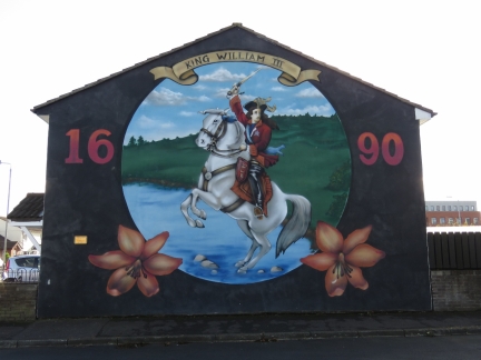
Belfast has a tradition of political murals dating from 1908. Protestant Unionists who supported British rule painted murals of King William III in protest of a Catholic-led push for Irish independence. The eventual Irish War for Independence culminated in the 1921 creation of the separate Republic of Ireland, but Northern Ireland’s predominately unionist population, most of whom descended from British colonists, opted to remain in Great Britain.
Northern Ireland’s population was made up of a mostly Protestant loyalist/unionist majority who favored British rule, and a mostly Catholic nationalist/republican minority who supported Irish Independence. Tension and hostility between the two groups erupted in the decades-long violence that became known as the Troubles. The mural tradition was revived during the Troubles. This modern mural in the unionist Shankill Road district is of Protestant King William III, also known as King Billy or William of Orange, who overcame Catholic James II in the 1690 Battle of the Boyne an event that still is commemorated annually in Northern Ireland by the Orange Order. |
 |
Stevie McKeag
Position: -5 56.53, 54 36.36
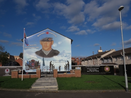
Although the Troubles officially ended with the 1998 cease-fire agreement, some murals were painted after that date. Several are a stark reminder of the events, and the feelings that will take generations to dissipate. Stevie McKeag was a unionist and a Commander of the Ulster Defence Association’s (UDA) ‘C’ Company in the 1990s. He earned the nickname “Top Gun” for frequently winning UDA’s annual “Volunteer of the Year” award, given to he organisation’s top hitman, and is associated with at least 12 deaths. McKeag died of a drug overdose in 2000 and over 1,000 supporters attended his funeral. This mural was painted following his death, with the words “Remember with Pride”.
|
 |
UYM
Position: -5 56.53, 54 36.36
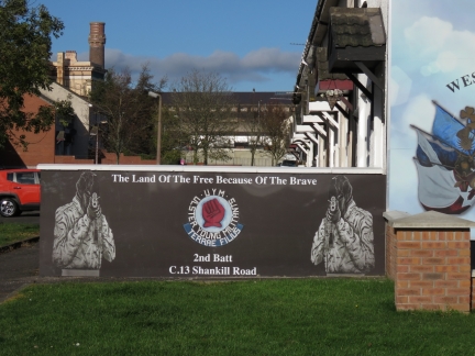
Ulster Young Militants memorial showing the “Red Hand of Ulster”, a unionist symbol.
|
 |
William McCullough
Position: -5 56.40, 54 36.36
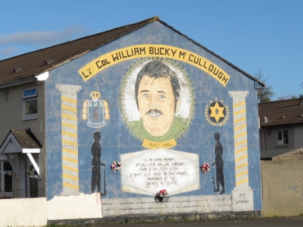
William McCullough was unionist paramilitary who had a reputation as a ruthless gunman and was involved with racketeering. He was killed in 1981 by the republican Irish National Liberation Army.
|
 |
Jackie Coulter
Position: -5 56.48, 54 36.31
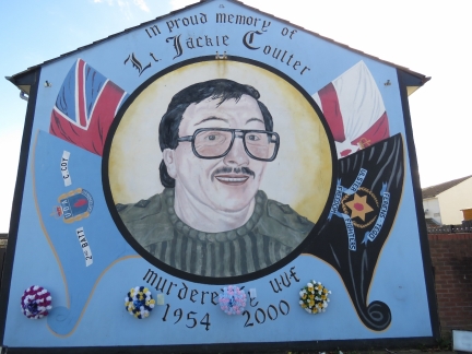
The violence wasn’t just between unionists and republicans. The unionists consisted of several competing organisations whose feuds resulted in several deaths. Unionist Jackie Coulter was killed in 2000 by a rival unionist paramilitary organisation.
|
 |
Loyalist Bonfire
Position: -5 56.54, 54 36.32
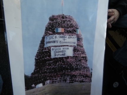
Every July 12th, some Northern Ireland Protestant unionists march through town to commemorate Protestant William of Orange’s 1690 victory over Catholic James II. Massive bonfires, some reaching 100ft high, are lit the night before as part of the celebration. Many bonfires also burn the flag of Ireland, Irish nationalist/republican symbols, Catholic symbols, and effigies. Not surprisingly, these displays often result in sectarian violence and attempts are being made to make the events more family-friendly. The celebration was one of the reasons we were nervous about being in Northern Ireland on July 12th earlier this year.
Our guide showed us this photo of one such bonfire. We don’t know when the picture was taken, but the “Parades Commission” referred to on the banner was formed in 2000 to restrict parades deemed offensive or contentious, so the bonfire was built within the past 20 years. |
 |
Loyalist
Position: -5 56.40, 54 36.30
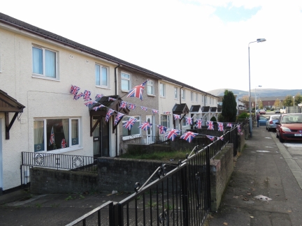
A display of British flags in the unionist Shankill Road district.
|
 |
Quilt
Position: -5 56.51, 54 36.36
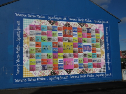
More modern West Belfast murals promote peace and co-existence. This patchwork quilt displays words related to women and the roles they play in families and communities.
|
 |
Angels
Position: -5 56.40, 54 36.36
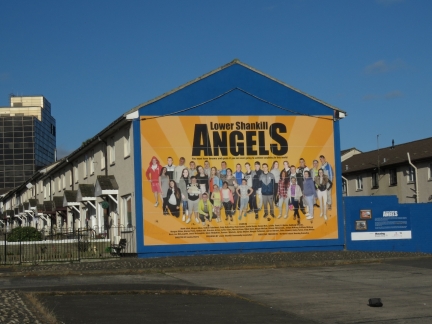
In sharp contrast to the paramilitary murals, the Lower Shankill Angels are a cross-community group of schoolchildren who created this movie-style poster.
|
 |
Memorial
Position: -5 56.54, 54 36.32
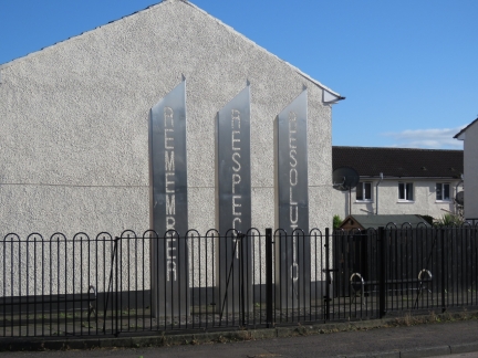
As part of a project to re-image Lower Shankill, nine paramilitary murals were removed in 2009 and the Remember/Respect/Resolution memorial was installed in 2011 on the site of a contentious former Oliver Cromwell mural. Cromwell was a 17th-century English political and military leader who was passionately opposed to the Catholic Church.
|
 |
The Lost Streets
Position: -5 56.55, 54 36.35
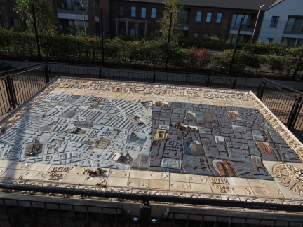
Not all the art in West Belfast is politically-charged. This sculpture, The Lost Streets, shows how the Shankill Road has changed over nearly a century by comparing 1920 to to 2012.
|
 |
Peace Line
Position: -5 57.12, 54 36.03
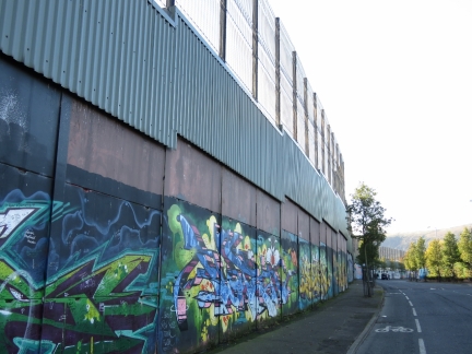
Perhaps the most visible reminder of the Troubles is the “Peace” Line, a series of barriers stretching a total of 34km that separate the largely Protestant unionist and the mainly Catholic republican communities in urban areas. Most of the barriers are in Belfast, with the remaining in Derry, Portadown and elsewhere. The “Peace” Line was started in 1969 as a temporary measure, but has outlasted the Berlin Wall that divided Berlin from 1961 to 1989. The height and number of barriers have actually increased since the 1998 cease-fire agreement, from 18 in the 1990s to at least 59 today. This portion of the wall is along the unionist side on Cupar Way.
|
 |
Gate
Position: -5 57.66, 54 36.10
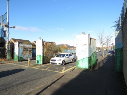
Gates along the “Peace” Line allows traffic and cars to pass. An agreement is in place to remove the barriers by 2023, but the gates still are closed nightly and all weekend to keep the groups apart and head-off any sudden violence. You can still walk or drive around the wall when the gates are closed, but this detour apparently is enough to limit problems. A study released in 2012 indicated that 69% of residents believe the walls still are necessary to prevent violence. Our guide said that a Catholic who attempted to live in the Protestant Lower Shankill Road area even today likely would be “burned-out” (a term used when a family is forced to leave through burning their house) or possibly killed.
|
 |
Clonard Martyrs Memorial Garden
Position: -5 57.48, 54 36.07
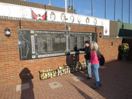
Against the “Peace” Line on the republican side we stopped at the Clonard Martyrs Memorial Garden in memory of those from the Greater Clonard area who died in the Troubles and in the Irish Stuggle for Indepencence, including “civilians murdered by loyalists and British forces during the course of the conflict”.
|
 |
Armour
Position: -5 57.46, 54 36.07
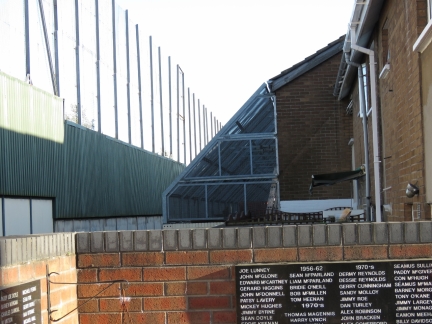
Homes adjacent to the “Peace” Line on the republican side are heavily armoured to prevent Molotov cocktails or other explosive from landing inside the houses.
|
 |
Bobby Sands
Position: -5 57.17, 54 35.88
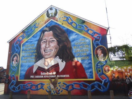
Provisional Irish Republican Army (IRA) member Bobby Sands was imprisoned in 1977 for planning and executing a Belfast bombing. He was elected to the House of Commons in 1981 while still in prison, but died from a hunger strike before he could take his seat. More than 100,000 people lined his funeral procession.
|
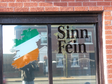 |
Sinn Fein
Position: -5 57.17, 54 35.88
On Falls Road at the office of Sinn Fein, an Irish republican party founded in 1905 and historically associated with the IRA.
|
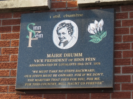 |
Maire Drumm
Position: -5 57.17, 54 35.87
Sinn Fein vice president Maire Drumm was killed in 1976 by a unionist paramilitary group while recovering from eye surgery in hospital.
|
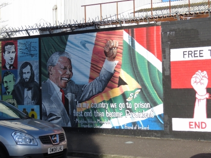 |
Nelson Mandela
Position: -5 56.80, 54 35.98
Nelson Mandela hosted the 1997 talks that resulted in the 1998 cease-fire agreement in Northern Ireland. This mural includes one of his famous quote: “In my country we go to prison first and then become President”.
|
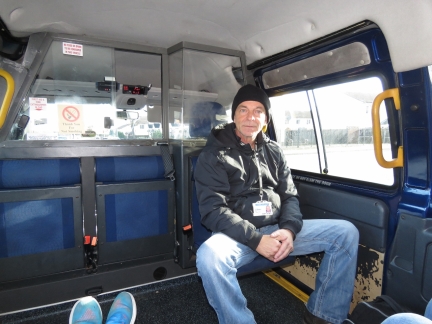 |
Joe
Position: -5 56.54, 54 36.32
Our driver Joe from Castlewellan, with Paddy Campbell’s Famous Black Cab Tours, grew up in Belfast during “The Troubles” and experienced the conflict first-hand. He did an awesome job of explaining the issues and bringing history to life. The weapons have mostly been set aside, but there still are two distinct sides and it will take generations for the memories of what happened during the Troubles to fade and be fully forgiven. Interestingly, both sides seem to agree on one thing now: that Brexit is not good for Ireland. Re-introducing border controls between Northern Ireland and the Republic of Ireland isn’t in anyone’s best interest.
|
 |
Crumlin Road Gaol
Position: -5 56.55, 54 36.53
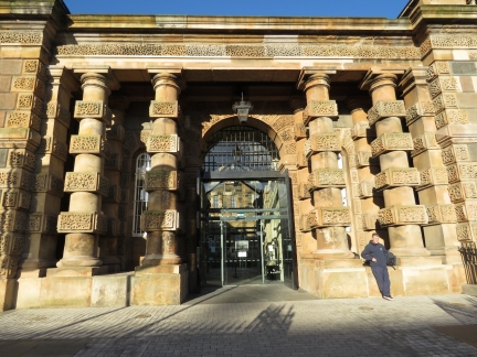
After our murals tour, we visited the Crumlin Road Gaol a former prison closed in 1996 and re-opened as a tourist attraction. This is the ornate street-level entry gate.
|
 |
Tunnel
Position: -5 56.53, 54 36.56
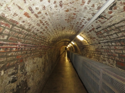
Prisoner’s didn’t enter the jail at street level. Rather they passed from the court building on the opposite side of the street via this tunnel under the road.
|
 |
The Circle
Position: -5 56.51, 54 36.58
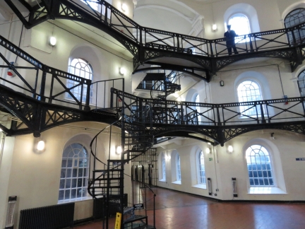
Completed in 1845, Crumlin Road Gaol was among the most advanced of its day. The prison consisted of four wings up to four storey’s high that extend from a central atrium called the Circle. With its natural light, high ceiling and wrought-iron walkways, the Circle looks quite attractive now, but that probably wasn’t the first impression of those interned here.
|
 |
Cell
Position: -5 56.52, 54 36.58
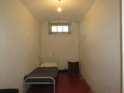
The Crumlin Road Gaol was the first Irish prison designed to separate prisoners with no communication between them. By the early 1970s the jail was overcrowded, with up to three prisoners per cell.
|
 |
Execution Room
Position: -5 56.52, 54 36.58
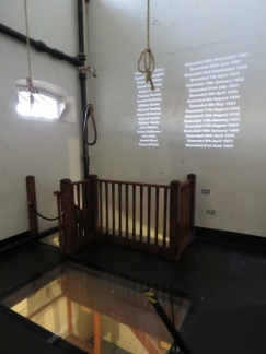
17 prisoners were executed at Crumlin Road Gaol between 1854 and 1961. Those awaiting execution were kept in a room with secret entrance to the execution room. On the day of their execution, the jailers slid open a secret panel and conveyed the prisoner into the execution room where they were hanged. The clear opening below the noose is where the floor would swing away from under the prisoner’s feet.
|
 |
Courthouse
Position: -5 56.50, 54 36.52
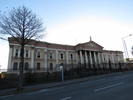
The old courthouse across the road from the jail is in ruin now, but plans are underway to renovate it as a hotel.
|
 |
Carlisle Memorial Church
Position: -5 56.19, 54 36.46
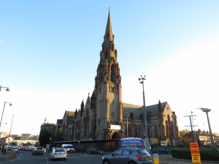
Carlisle Memorial Church was completed in 1845 and once was home to one of the largest Methodist congregations in Belfast. The building has been unused since 1982, due to a declining congregation and its location at a major interface between Catholic and Protestant populations. In 2015 renovations began on the building, that is now is perceived as neutral territory and might see joint use.
|
 |
St. Patrick’s Church
Position: -5 55.93, 54 36.31
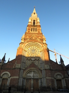
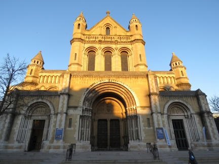
St. Patrick’s Roman Catholic church was dedicated in 1877.
|
 |
St. Anne’s Cathedral
Position: -5 55.77, 54 36.15
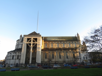
St. Anne’s Cathedral, also know as Belfast Cathedral, was completed in several stages starting in the early 1900s.
|
 |
North Transept
Position: -5 55.75, 54 36.19
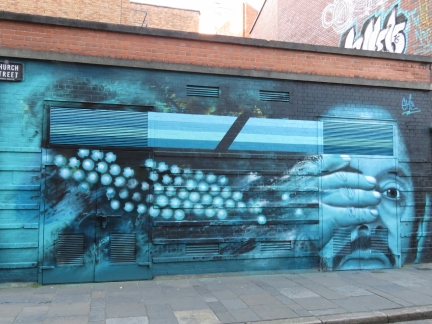
The north transept at St. Anne’s Cathedral features a huge Celtic cross and was completed in 1981.
|
 |
Silicone Head
Position: -5 55.84, 54 36.12
In addition to the political murals, Belfast also has a thriving street art community. Artist Emic drew this one on Church Street called “Silicone Head”.
|

|
Click the travel log icon on the left to see these locations on a map, with the complete log of our cruise.
On the map page, clicking on a camera or text icon will display a picture and/or log entry for that location, and clicking on the smaller icons along the route will display latitude, longitude and other navigation data for that location. And a live map of our current route and most recent log entries always is available at http://mvdirona.com/maps. |

Thank you for this post, neat details and makes me want to visit to see Belfast as well. My wife was there in 1984 for a brief tour and her parents were worried! May peace prevail!
Did anyone you meet talk about Brexit and the Irish border? Interesting ramifications.
The current Northern Ireland/Ireland border is essentially invisible and completely friction free. Residents that we talked to on both sides don’t want to see that change with Brexit.
Reminds me of this song originally by the Decemberists and covered by a great Austin musician Sarah Jarosz – https://www.youtube.com/watch?v=MIF9U4KDdWg
People (especially white westerners) forget that sectarian violence and terrorism isn’t / wasn’t limited to the Middle East or Africa … I missed many days of school when in college in London to bomb threats in the early 90s.
It’s good to see those days behind us. Unfortunately, much of the world is not in the better place that Northern Ireland has achieved.