
With the short daylight hours of the Norwegian winter, we were underway in the dark for much of the time, particularly when making trips in longer waterways such as 110-nm Sognefjord, Norway’s longest fjord. This is more difficult than during the day, but can also be more enjoyable with beautiful night views.
From Skjolden at the extreme head of Sognefjord, we began our slow return journey. We toured Ardalsfjorden and stopped for a night in Kaupanger before continuing on to spend two nights at Sogndalsfjorden. In Ardalsfjorden we passed the Ofredal Tunnel, considered the steepest in the world with a grade of 15.5% or 6:1 and in Kaupanger we anchored in sight of 5,823 ft (1,775 m) Bleia, Norway’s highest mountain “without water in the fjord”. After passing under the striking Sogndalsfjora Bridge, pictured above, we enjoyed a peaceful anchorage at the head of Sogndalsfjorden and made an enjoyable winter hike up to 1968-ft (600m) Helgasete.
Below are highlights from November 4th through 6th, 2020. Click any image for a larger view, or click the position to view the location on a map. And a live map of our current route and most recent log entries always is available at mvdirona.com/maps.
 |
Forward Spotlight
Position: 61°28.21’N, 7°33.39’E
Underway in the dark at 6am from Skjolden with our forward spotlight punching through the night.
|
 |
Heating
Position: 61°27.12’N, 7°31.13’E
When we’re underway in the colder weather, we run the temperature up to 80°F (26°C) in the master and guest staterooms to keep everything as dry as possible and decrease the likelihood of mold developing. Our hydronic heating system is plumbed to use heat from either the diesel boiler or the main engine, so it’s almost free heat when the engine is running.
|
 |
Ardalsfjorden
Position: 61°12.65’N, 7°37.12’E
Underway in Ardalsfjorden, a branch near the head of Sognefjord.
|
 |
Ardalstangen
Position: 61°13.36’N, 7°39.91’E
We’d considered anchoring off Ardalstangen, but the bay was fairly open and the only place with sufficient swing room for the depth was right off the commercial port.
|
 |
Ofredal Tunnel
Position: 61°13.58’N, 7°39.92’E
The south end of Ofredal Tunnel near Ardalstangen. The 1.4-mile (2.2 km) tunnel has a grade of 15.5% or 6:1, and is considered the steepest in the world. The access roads were completed before the tunnel was constructed in the 1990s when the tunnel was halfway completed a miscalculation was discovered in that the tunnel would end 30 meters below the road at the other end at a constant grade. The problem was rectified by increasing the grade to 15.5% for the last half to allow the tunnel to meet the road.
|
 |
Ullensvang
Position: 61°9.37’N, 7°20.29’E
The ferry Ullensvang arriving into Manheller from Fodnes. This is another Norwegian tunnel-to-ferry connection where the ferry dock leads directly to a tunnel.
|
 |
Bleia
Position: 61°9.41’N, 7°18.89’E
The 5,823 ft (1,775 m) mountain Bleia rises from waters almost 3,300ft (1,000m) deep, making it the highest mountain in Norway if the Sognefjord was empty of water.
|
 |
Kaupanger Anchorage
Position: 61°10.89’N, 7°14.93’E
Our anchorage at Kaupanger in 117 ft (35 m) on 330 ft (100 m) of rode.
|
 |
Aurland
Position: 61°10.88’N, 7°14.94’E
The ferry Aurland departing Kaupanger with 5,823 ft (1,775 m) Bleia in the background, viewed from our anchorage.
|
 |
Kaupanger
Position: 61°10.86’N, 7°14.87’E
The town of Kaupanger aglow with winter lights.
|
 |
Raising Anchor
Position: 61°10.58’N, 7°15.00’E
Jennifer finishing the deck work after raising anchor as we depart the anchorage at Kaupanger. With the days getting colder, she’s started wearing her Mustang 2175 to keep warm during morning deck work.
|
 |
Fardalselvi
Position: 61°10.94’N, 7°1.84’E
Waterfall from the river Fardalselvi gushing into Sogndalsfjorden, an arm of Sognefjord.
|
 |
Sogndalsfjora
Position: 61°13.49’N, 7°6.81’E
Approaching the bridge across Sogndalsfjorden at the village of Sogndalsfjora, population 2,000.
|
 |
Sogndalsfjora Bridge
Position: 61°13.85’N, 7°7.20’E
Passing under the Sogndalsfjora Bridge across Sogndalsfjorden, a branch of Sognefjord. The bridge has a clearance of 42 ft (13m), plenty for our 30-ft (9.1m) air draft. But it sure looks tight.
|
 |
Sogndalsfjorden Anchorage
Position: 61°15.77’N, 7°10.07’E
Our anchorage at the head of Sogndalsfjorden in 66 ft (20 m) on 300 ft (91 m) of rode
|
 |
Dishwasher Basket
Position: 61°15.77’N, 7°10.08’E
One of the arms in our dishwasher basket corroded and broke off.
|
 |
Media Filter Backflush
Position: 61°15.78’N, 7°10.08’E
We have a media filter in front of our water maker prefilter. The media filter is essentially a small sand filter very siimilar to that used on swimming pools. It’s super effective. In plankton rich waters, water maker prefilters can need to be replaced or cleaned weekly and sometimes as often as daily. With the media filter, we only change the prefilter annually when we change the carbon flush filter. The media filter has pressure gauges showing when it needs to be cleaned, but we find it can go a very long time without building much back-pressure, so we just schedule the media filter for back-flushing monthly.
Cleaning the filter is quick and easy process. We reverse the valves, then run the booster pump, which runs seawater through the filter in the opposite direction, cleaning it. Here you can see the brown flush water coming out at the start of the flush cycle. We run the booster pump until the outflow water is clear, then shut it down and restore the valves to the forward flow. |
 |
Battery Testing
Position: 61°15.78’N, 7°10.08’E
The tender batteries were due for a biannual test. The primary battery (pictured) tested bad but operative at 114 CCA (cold-cranking amps) on a design spec of 240, the backup we keep in the tender was bad and inoperative at 34 CCA on a spec of 175, and the spare was ok at 175 CCA on a spec of 240. Looks like we have a battery purchase in our future.
|
 |
Replacing Tender Battery
Position: 61°15.78’N, 7°10.08’E
Based on the results of our tender battery test, we replaced the primary battery with the spare, made the primary be backup on the tender, and moved the backup on board as a spare and will replace it as soon as possible.
|
 |
Tender
Position: 61°15.14’N, 7°10.10’E
Tying off the tender at the head of Sogndalsfjorden to convenient post for a hike ashore.
|
 |
Trailhead
Position: 61°15.19’N, 7°10.23’E
At the trailhead for a hike up 1968-ft (600m) Helgasete at the head of Sogndalsfjorden.
|
 |
Steps
Position: 61°15.52’N, 7°10.70’E
Steps along the trail to Helgasete, with the ubiquitous Norwegian Trekking Association red ‘T’ marking the way.
|
 |
Dirona
Position: 61°15.58’N, 7°10.77’E
View to Dirona anchored at the head of Sogndalsfjorden from the trail to Helgasete.
|
 |
Sagelvi
Position: 61°15.58’N, 7°10.79’E
Enjoying the flow from the river Sagelvi from the bridge across. Dirona is just visible at anchor at roughly the center of the picture (click image for a larger view).
|
 |
Dal
Position: 61°15.91’N, 7°11.11’E
Old mountain farm building at Dal with a waterfall just visible through the trees in the background.
|
 |
Creek
Position: 61°16.05’N, 7°11.55’E
Crossing a creek on the trail to Helgasete. We started the hike all bundled up, but have warmed up from the hike and now are down to T-shirts on top.
|
 |
Helgasete
Position: 61°16.28’N, 7°12.31’E
A picnic lunch at 1968-ft (600m) Helgasete looking southwest across a group of cabins with Sognefjord just visible in the distance. We’ve got all our layers back on again once we stopped moving.
|
 |
Brrr
Position: 61°16.27’N, 7°12.30’E
The temperature felt a little cold at Helgasete and this thermometer reading 7°C (°F) confirmed it.
|
 |
Bridge
Position: 61°16.23’N, 7°12.01’E
Crossing a small footbridge over a creek on an alternate route back down from Helgasete.
|
 |
Leaves
Position: 61°15.55’N, 7°10.75’E
Kicking up the fall leaves on the trail from Helgasete.
|
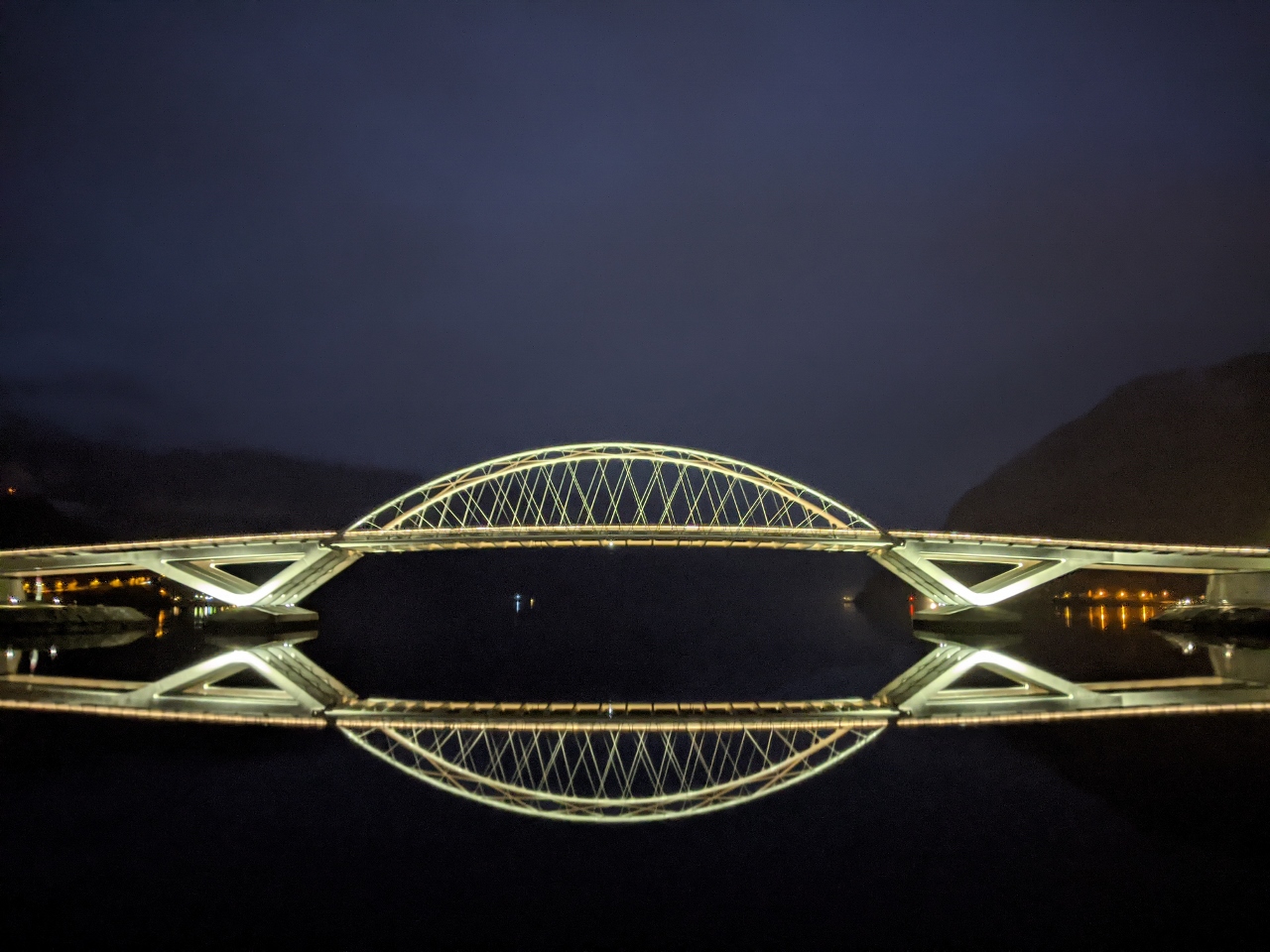 |
Sogndalsfjora Bridge
Position: 61°14.08’N, 7°7.37’E
The striking Sogndalsfjora Bridge reflecting into still waters as we depart Sogndalsfjorden on a calm morning.
|
 |
Sogndalsfjora
Position: 61°13.89’N, 7°7.26’E
The lights of Sogndalsfjora around 7am. The sun won’t rise for another couple of hours.
|
 |
Click the travel log icon on the left to see these locations on a map, with the complete log of our cruise.
On the map page, clicking on a camera or text icon will display a picture and/or log entry for that location, and clicking on the smaller icons along the route will display latitude, longitude and other navigation data for that location. And a live map of our current route and most recent log entries always is available at mvdirona.com/maps. |
If your comment doesn't show up right away, send us email and we'll dredge it out of the spam filter.