In 1936, Lifjorden was the site of Norway’s first fatal civil aviation accident. Classified as a “controlled flight into terrain”, the crew of the seaplane Havorn didn’t realize they were off course in a thick fog and flew the aircraft directly into the 2,513-ft (776m) cliff Risnesnipa, pictured at left above, killing all seven on board.
A memorial near the crash site commemorates the tragedy and also marks the trailhead to the accident site high up the cliff. Other trails lead up to the top of the steep-edged Lifjell massif that includes Risnesnipa, 2,329-ft (710m) Gygrekjeften, and 1,893-ft (577m) Hogeheia. The area is known for its excellent view hikes.
After an overnight stop at Fuglsetfjorden, a branch of Sognefjord, Lifjorden was our final stop in Norway’s longest fjord. We toured the area by tender, viewed the memorial, were chased by a herd of surprisingly aggressive goats, and hiked around the base of Risnesnipa.
Below are highlights from November 9th to 12th, 2020. Click any image for a larger view, or click the position to view the location on a map. And a live map of our current route and most recent log entries always is available at mvdirona.com/maps.
 |
Fish Farm
Position: 61°5.84’N, 5°50.02’E
As we ran south in the dark into Fuglsetfjorden, a branch of Sognefjord, we could see the lights of two fish farms. Their individual pens showed up clearly on the radar. We’ve been really happy with our 2010 Furuno NavNet 3D installation. The radar quality in particular is such a huge step up from the earlier generation of Raymarine that we installed on our previous boat in 1999. Doubtless the current decade-newer technology is even better, but the resolution and performance of the Furuno DRS25 remains impressive to us.
|
 |
Fuglsetfjorden Anchorage
Position: 61°4.26’N, 5°48.30’E
Our lunch anchorage at the head of Fuglsetfjorden in 39 ft (12 m) on 200 ft (61 m) of rode.
|
 |
Fuglsetfjorden View
Position: 61°4.25’N, 5°48.30’E
Views to Fuglsetfjorden from our anchorage (clockwise from top left: forward, aft, starboard and port).
|
 |
39 Amps
Position: 61°4.25’N, 5°48.30’E
Our Northern Lights 12kW generator has been running wonderfully since the replacing the cylinder head 628 hours ago. At 7,370 hours it doesn’t smoke, doesn’t consume oil and can hold exactly the same load today as it did when delivered 11 years ago. Here it’s producing 39 amps at 1760 RPM, running along at a comfortable 187°F (86°C), as it usually does.
|
 |
Power Lines
Position: 61°5.89’N, 5°49.89’E
As we were entering Fuglsetfjorden in the dark this morning, an ARPA (automatic radar plotting aid) target that we couldn’t spot visually had us a bit concerned. We slowed and put on our big forward spotlight and side floodlights, but there was absolutely nothing in the area. We later realized that what we were seeing was the radar reflection off the power line crossing the fjord.
In this screenshot taken on our way back out, you can see the target is tracking from left to right, across our path, with a 64-yard estimated CPA (closest point of approach) shown at right. And if you look closely at the picture, you can see the target is tracking along the marked power line. |
 |
Oystrebo Anchorage
Position: 61°3.63’N, 5°40.75’E
Our anchorage off Oystrebo at the head of Fuglsetfjorden, a branch of Sognefjord, in 39 ft (12 m) on 200 ft (61 m) of rode.
|
 |
Oystrebo
Position: 61°3.63’N, 5°40.75’E
The village of Oystrebo and 2358-ft (719m) Skraa reflecting into still waters at the head of Fuglsetfjorden, a branch of Sognefjord.
|
 |
Anchor Lines
Position: 61°5.06’N, 5°35.81’E
The charted anchor lines for this fish farm, marked with buoys, extend nearly 1.5 miles from the farm. That’s a surprisingly long distance.
|
 |
Approaching Lifjorden
Position: 61°8.04’N, 5°11.82’E
Approaching Lifjorden with the 2550-ft (777m) Lifjell mountain plateau prominent beyond.
|
 |
Mine
Position: 61°8.14’N, 5°11.79’E
The processing portion of a fairly substantial surface mine in Listraumen, the entrance channel to Lifjorden. Norway has an amazing amount of industry spread throughout the country.
|
 |
Shallow
Position: 61°8.67’N, 5°11.80’E
The water depth in Listraumen is 14ft (4.2m), plenty for Dirona‘s 6.6ft (2.1m) draught. But the water is so clear that the bottom appears disconcertingly close to the surface.
|
 |
Current
Position: 61°8.71’N, 5°11.79’E
The current in Listraumen was flowing several knots against us as we entered. At 1100 RPM we were making only 2.8 knots where normally we’d be doing 5.6.
|
 |
Lifjorden Anchorage
Position: 61°8.88’N, 5°12.87’E
Our anchorage in Lifjorden at the mouth of Sognefjord, in 111 ft (34 m) on 350 ft (107 m) of rode.
|
 |
Lifjorden views
Position: 61°8.87’N, 5°12.87’E
Views to Lifjorden from our anchorage (clockwise from top left: forward, aft, starboard and port).
|
 |
Windlass Maintenance
Position: 61°8.87’N, 5°12.84’E
Time for the annual clean and lubrication of the windlass top end.
|
 |
Dirona
Position: 61°8.88’N, 5°12.87’E
Dirona at anchor on an ultra-calm day in Lifjorden.
|
|
|
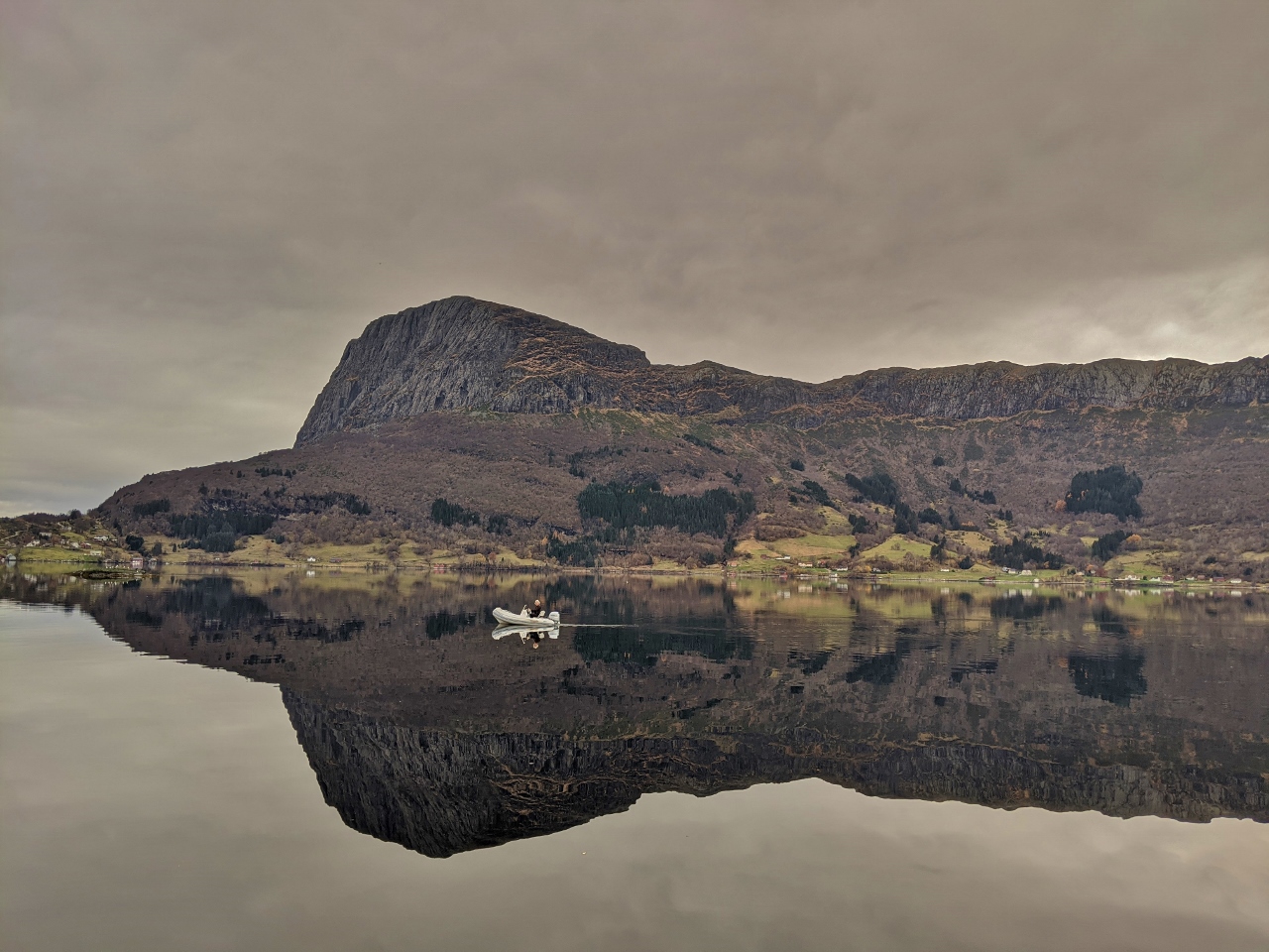
Lifjell
Position: 61°8.88’N, 5°12.87’E
James out in the tender with the Lifjell mountain plateau beyond, reflected almost perfectly into the still waters of Lifjorden.
|
 |
Oil Change
Position: 61°8.86’N, 5°12.86’E
Performing the 33rd oil change, and the 5th this year, on our Northern Lights 12kW generator. We’ve been really winding on the hours this year at 1,161 so far.
|
 |
Seals
Position: 61°8.86’N, 5°12.86’E
Seals sunning on the rocks behind our anchorage at Lifjorden. We could hear them barking all morning.
|
 |
Risnes
Position: 61°8.88’N, 5°11.00’E
The tender moored on the dock at Risnes for a hike ashore.
|
 |
Havorn Memorial
Position: 61°8.96’N, 5°10.44’E
Memorial at Risnes commemorating the 1936 crash of the mail and passenger plane Havorn. All seven on board died in Norway’s first fatal civil aviation accident. The cause was classified as a “controlled flight into terrain”, where the crew didn’t realize they were off course in a thick fog and flew the aircraft directly into Risnesnipa, visible in the background.
|
 |
Posse
Position: 61°9.00’N, 5°10.43’E
While we were at the Havorn Memorial, a group of aggressive goats charged up the hill behind us, seemingly wanting us out of there. We took the hint and left, and “the leader” followed us quite a way down the hill until we were a good distance away. Their job done, the “posse” departed as quickly as they’d arrived. We were reminded of the field of aggressive bulls we’d inadvertently crossed through in Ireland in 2017.
|
 |
Trailhead
Position: 61°9.04’N, 5°10.31’E
At the trailhead for a hike beneath Risnesnipa. The area is full of excellent marked trails, but we need more hours of daylight to make most of them. We’ll have to return in the summer.
|
 |
Lifjorden
Position: 61°9.14’N, 5°9.98’E
View to southeast to Lifjorden from the trail beneath Risnesnipa. Dirona is anchored just out of the picture on the left and the channel we entered through, Listraumen, is visible at upper left with the white patch of the mine we passed prominent.
|
 |
Choices
Position: 61°9.40’N, 5°10.68’E
At an intersection of several trails in the Lifjell mountain plateau area. We’ve just come from Stolen/Haugane and will descend on Ekrestein (not visible) to make a loop. The other trails lead up higher to the plateau.
|
 |
Stepping Down
Position: 61°9.34’N, 5°10.70’E
On the way down the trail back to Risnes, we’re not sure if this is a big step or just short legs :).
|
 |
Ytre Listraumen
Position: 61°8.82’N, 5°10.49’E
Current in Ytre Listraumen as we tour of the area by tender after our hike. The marked channel is easily passed in small boats, and appears passable in Dirona as well, but is a little tight and shallow for our tastes with the current.
|
 |
Dirona Health Clinic
Position: 61°8.86’N, 5°12.75’E
We check our blood pressure every three months. Here’s Jennifer getting a blood pressure check using an Omron Wrist Blood Pressure Monitor.
|
 |
Blood Glucose
Position: 61°8.86’N, 5°12.76’E
James’ family has some diabetes, so we check our blood glucose levels every three months using a TRUEresult Blood Glucose Monitoring System. We passed all the tests.
|
 |
Exiting Listraumen
Position: 61°8.79’N, 5°11.77’E
Exiting Listraumen shortly after sunrise. The tide was higher when we departed, and the water level in the channel was deeper with less current.
|
 |
Click the travel log icon on the left to see these locations on a map, with the complete log of our cruise.
On the map page, clicking on a camera or text icon will display a picture and/or log entry for that location, and clicking on the smaller icons along the route will display latitude, longitude and other navigation data for that location. And a live map of our current route and most recent log entries always is available at mvdirona.com/maps. |
If your comment doesn't show up right away, send us email and we'll dredge it out of the spam filter.