
From Finnafjorden we continued our detailed exploration of Sognefjord and travelled a short 15 miles miles to Balestrand. We anchored there for three nights, exploring the area by tender and hiking up through snow to the day cabin at the top of 3188-ft (972m) Raudmelen.
Below are highlights from October 26th through 28th, 2020. Click any image for a larger view, or click the position to view the location on a map. And a live map of our current route and most recent log entries always is available at mvdirona.com/maps.
 |
Kviknes Hotel
Position: 61°12.41’N, 6°32.81’E
The majestic Sognefjord scenery around the historic Kviknes Hotel in Balestrand has attracted many rich and famous guests, including Royalty, prime ministers, and film stars.
|
 |
Esefjorden Anchorage
Position: 61°17.74’N, 6°33.46’E
Our anchorage in Esefjorden in 51 ft (17 m) on 200ft (61 m) of rode.
|
 |
Dirona
Position: 61°13.00’N, 6°30.36’E
Dirona anchored beneath 4,200-ft (1300m) snow-dusted mountains in Esefjorden off Balestrand.
|
 |
Tender
Position: 61°13.02’N, 6°30.33’E
Out for a tender tour of Esefjorden and Vetlefjorden.
|
 |
Stolsskreda
Position: 61°16.75’N, 6°33.85’E
Fall colors surrounding the waterfall from the river Stolsskreda in Vetlefjorden.
|
 |
Ulvastad
Position: 61°17.91’N, 6°33.60’E
The village of Ulvastad at the head of Vetlefjorden. With so many settlements throughout the coast, it’s hard to believe the country’s entire population is only 5.3 million.
|
 |
Porgy
Position: 61°17.43’N, 6°33.37’E
The vehicle carrier’s Porgy (closest) and Asian Emperor med-moored at Vetlefjorden during the economic downturn. The storage location looks new, with recent construction to build shore-attachments and supply power. The 650-ft (200m) vessels among the few things that don’t look miniscule in the scale of the fjords. These ships stand out for miles and look very out of place.
|
 |
Svaerajforden
Position: 61°16.30’N, 6°31.15’E
Spectacular reflections in Svaerajforden, an arm of Vetlefjorden.
|
 |
Beacon for Travelers
Position: 61°12.64’N, 6°32.25’E
The striking sculpture Beacon for Travelers by Balestrand artist Geir Hjetland at the guest harbour of his hometown.
|
 |
Bunkering
Position: 61°12.98’N, 6°30.32’E
We’ve used up all the fuel in our 4 1.25-gallon and 5-gallon tank, so it’s time to refill them from the big 29-gallon deck tanks. We’ve been using the tender a ton on this trip and are really going through the gasoline.
|
 |
Dusk
Position: 61°12.98’N, 6°30.30’E
Tranquil dusk scene from the anchorage at Esefjorden off Balestrand.
|
 |
Sunrise
Position: 61°12.99’N, 6°30.31’E
Sunrise on a calm morning from the anchorage at Balestrand.
|
 |
Tender
Position: 61°12.62’N, 6°32.21’E
The tender mooored at Balestrand guest harbour for a hike up Raudmelen.
|
 |
Mailboxes
Position: 61°12.33’N, 6°31.65’E
Wonderfully crafted mailbox shelter in Balestrand.
|
 |
Trailhead
Position: 61°12.34’N, 6°31.45’E
At the trailhead for 3188-ft (972m) Raudmelen, the leftmost trail in red on the signboard (click image for a larger view). Like most Norwegian towns, Balestrand has an extensive and well-developed trail network that residents use heavily.
|
 |
Orrabenken
Position: 61°12.47’N, 6°30.98’E
A fantastic view over Balestrand and up Sognefjord from the Orrabenken viewpoint on the trail to Raudmelen.
|
 |
Boardwalk
Position: 61°12.46’N, 6°30.86’E
Walking across a boardwalk at altitude 1306 ft (398 m). The temperature is in the low 40s F (4-5°C), but we’ve gotten so warm from hiking that we’ve stripped our top layer down to just a T-shirt. There’s a thin layer of ice on the wood, and so staying on the boards is a challenge.
|
 |
Salastolen
Position: 61°12.41’N, 6°30.49’E
A mother and daughter team from Balestrand enjoying the view from a brand new bench that they told us was just installed the day before. We could still smell the fresh pine. They hike up to the Salastolen viewpoint every other day and about weekly to the top.
|
 |
Burasi
Position: 61°12.32’N, 6°29.87’E
A hobbit’s second breakfast at altitude 1924 ft (586 m) at the Burasi viewpoint with spectacular snow-tipped peaks all around. What an amazing hike so far, and we haven’t even reached the top yet.
|
 |
Steps
Position: 61°11.91’N, 6°29.51’E
The trail to Raudmelen is very popular with the locals, and well-built with large stone steps. At altitude 2554 ft (778 m) we’re getting above the snow line.
|
 |
DNT
Position: 61°11.90’N, 6°29.48’E
A ubiquitous red ‘T’ marking a DNT (Norwegian Trekking Association) trail. Dirona is anchored in the bay beyond, just out of sight to the right.
|
 |
Airlift
Position: 61°11.81’N, 6°29.24’E
The stones used to build the stairs on the trails to Raudmelen are airlifted in by helicopter. Air transit for stones seems a bit unusual, but helicopters are used extensively in many Norwegian construction projects.
|
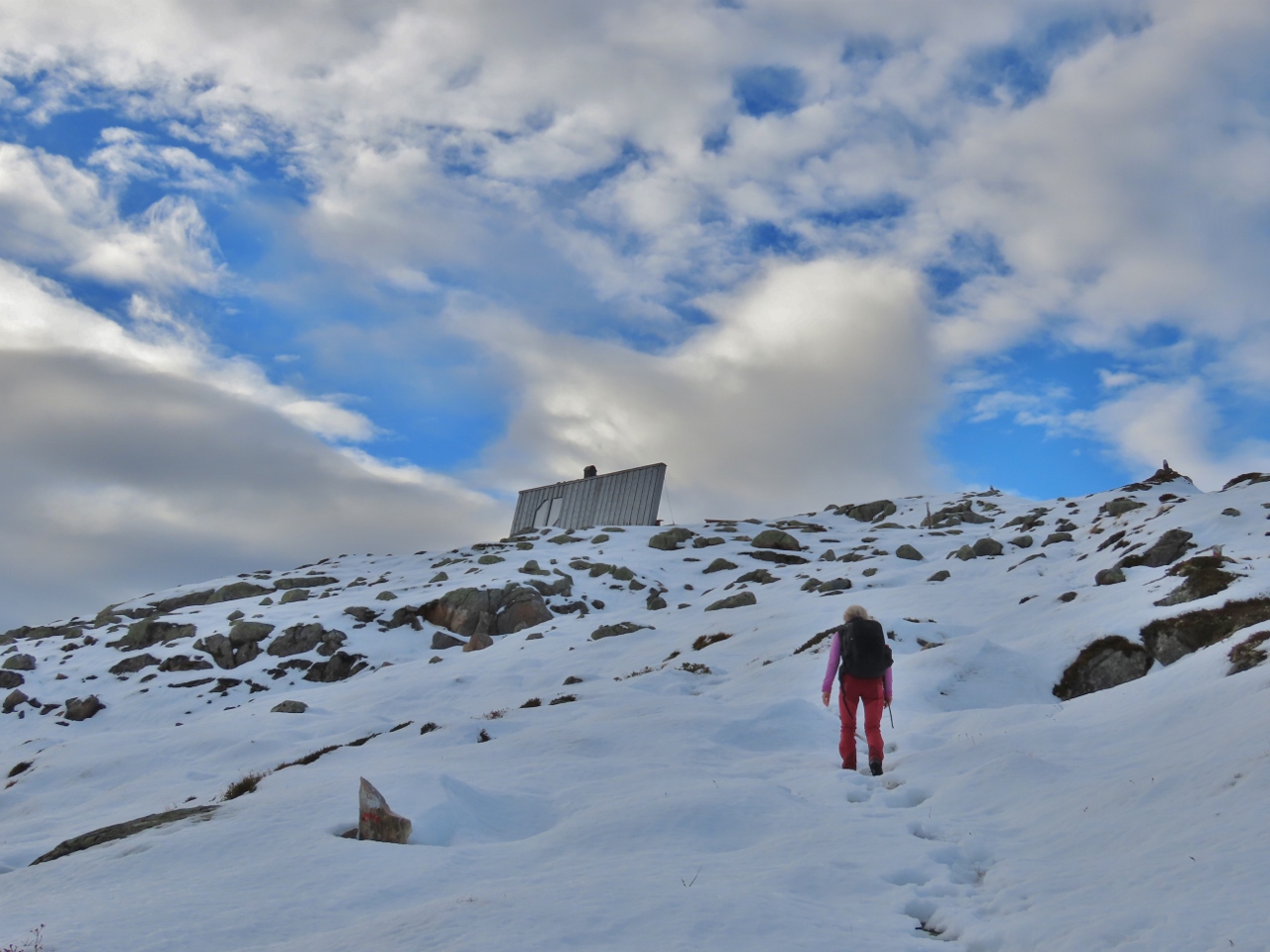 |
Near Summit
Position: 61°11.75’N, 6°29.10’E
Nearing the summit of Raudmelen at altitude 3139 ft (956 m). The trail is covered in snow now, but still pretty easy to follow and not very slippery to walk on. The modern cabin visible at the summit was built as part of contest for student architects.
|
 |
Summit
Position: 61°11.70’N, 6°29.01’E
At the snowy summit of 3188-ft (972m) Raudmelen looking east up Sognefjord.
|
 |
Panorama
Position: 61°11.71’N, 6°29.01’E
The panoramic view east from the summit of 3188-ft (972m) Raudmelen (click image for a larger view).
|
 |
Lunch
Position: 61°11.72’N, 6°29.06’E
Lunch inside the beautiful day cabin atop Raudmelen, with a picture-window view east into Sognefjord.
|
 |
Descending
Position: 61°11.71’N, 6°28.74’E
We climbed to Raudmelen on a trail along the northeast flank and are descending along the south side. Based on the footprints in the snow, this trail down was less-followed than the one we’d taken to the top and a little more difficult to find in the snow. But the ut.no app also showed the trail and we could see where we were on GPS, so had little difficulty following it.
|
 |
Vetlefjorden
Position: 61°11.71’N, 6°28.74’E
As we descended on the new trail, we got a great fiew to Vetlefjorden, in the distance at right, that we’d explored in the tender yesterday. Dirona at anchor is the small white at roughly center of the picture (click image for a larger view).
|
 |
Finger Boards
Position: 61°11.70’N, 6°28.12’E
Finger boards and red arrows at altitude 3120 ft (951 m) indicating distances to various waypoints. We’ve just come from Raudmelen and are heading towards Kalbakk.
|
 |
Slope
Position: 61°11.65’N, 6°28.31’E
Snow-covered slope west of Raudmelen.
|
 |
Stepping Down
Position: 61°11.62’N, 6°28.36’E
This trail also had large stepping stones in many of the steep parts. They were a little slippery with the snow, and we were careful stepping down.
|
 |
Snowline
Position: 61°11.51’N, 6°28.37’E
At altitude 2452 ft (747 m) the snow is thinning as we descend into the valley at Kalbakk.
|
 |
Boardwalk
Position: 61°11.38’N, 6°28.94’E
Walking across a series of snow-covered boardwalks towards the trekking cabin at Kalbakk. We just descended down the ridge at right. The scenery is just spectacular.
|
 |
Kalbakk
Position: 61°11.35’N, 6°29.34’E
The rustic trekker’s cabin at Kalbakk at altitude 2176 ft (663 m).
|
 |
Toilet
Position: 61°11.35’N, 6°29.27’E
The wonderfully-crafted pine-enclosed self-composting toilet at Kalbakk.
|
 |
Fjerestadgrovi
Position: 61°12.14’N, 6°31.06’E
Enjoying the view from a bench on a bridge across the river Fjerestadgrovi, one of several bridges we crossed on the return route.
|
 |
Hedgehog
Position: 61°12.45’N, 6°31.96’E
European hedgehog foraging in Balestrad. It seemed unconcerned with us being nearby—whatever it was eating must be pretty tasty.
|
 |
St. Olaf’s Church
Position: 61°12.47’N, 6°32.06’E
St. Olaf’s Church in Balestrand was built in 1897 following the design of medieval wooden Scandanavian stave churches.
|
 |
Rowers
Position: 61°12.68’N, 6°32.17’E
As we returned in the tender to Dirona, dozens of schoolchildren were afloat or in the process of launching boats into the bay. 3188-ft (972m) Raudmelen that we just hiked is roughly at center of the picture in the distance.
|
 |
Moonrise
Position: 61°12.99’N, 6°30.28’E
Fabulous moonrise over Balestrand at dusk.
|
 |
Dirona in a Bathtub
Position: 61°12.98’N, 6°30.29’E
When we were in Sweden last year, Olle Skold stopped by for a visit with the 3D printed model of Dirona he was working on. We’ve kept in touch as he’s continued to evolve the model. He added lights a few weeks ago and now has the model floating in a bathtub with the tender on the boat deck. It looks fantastic.
You can see a wider variety of his work and get in touch with Olle at http://depronized.com/. |
 |
Pallet
Position: 61°12.98’N, 6°30.31’E
Pallet of parts and equipment being shipped by sea freight to us in Norway.
|
 |
Spotlight
Position: 61°12.98’N, 6°30.32’E
We’re very happy with our forward spotlight upgrade, but wanted the beam to be a little wider. Here James is up the stack to tilt two of the four light bars more outboard to give a wider beam. We now have a much wider beam forward that seems just as bright.
|
 |
Click the travel log icon on the left to see these locations on a map, with the complete log of our cruise.
On the map page, clicking on a camera or text icon will display a picture and/or log entry for that location, and clicking on the smaller icons along the route will display latitude, longitude and other navigation data for that location. And a live map of our current route and most recent log entries always is available at mvdirona.com/maps. |
If your comment doesn't show up right away, send us email and we'll dredge it out of the spam filter.