
The narrow and shallow channels leading into the large basins near Lindas, Norway are subject to strong tidal currents, making entry difficult for larger displacement vessels at other than slack water. The entry was important enough that a saltwater lock was completed in 1908 to allow steamships to enter at any stage of the tide. The lock is one of only two saltwater locks in Norway (the other is the Skjoldastraumen Lock that we visited a few weeks earlier). With the advent of roads in the area, the lock fell into disuse in the 1950s and the gates were left permanently open starting in 1963.
From the island of Osteroy, we continued our slow cruise north, stopping for a night at the island of Holsnoy before spending three nights in the Lindas area. At Holsnoy, we met up with longtime blog reader Trond Saetre and his partner Margareth Baartvedt, who happened to be out cruising nearby.
We later brought Dirona through the Lindas lock at slack water, then ran the tender through at full current. We can confirm that the locks definitely are required at other than slack water—the current really rushes through the passage otherwise.
At another nearby channel, we got some help from a local resident to pass through Verasstraumen narrows in swift current, and we also viewed several installations of “The Sea Park in Lindasosane”, an outdoor art exhibit viewable only by boat.
Below are highlights from Sept. 20th through 23rd, 2020. Click any image for a larger view, or click the position to view the location on a map. And a live map of our current route and most recent log entries always is available at mvdirona.com/maps.
 |
Knarvik Ferry Dock
Position: 60°32.49’N, 5°17.64’E
High-speed passenger ferry docked at Knarvik, opposite the western tip of the island of Osteroy. Before road bridges were completed in 1994 connecting Knarvik to nearby Bergen by road, the car ferry connection between them carried more cars than any other in Norway.
|
 |
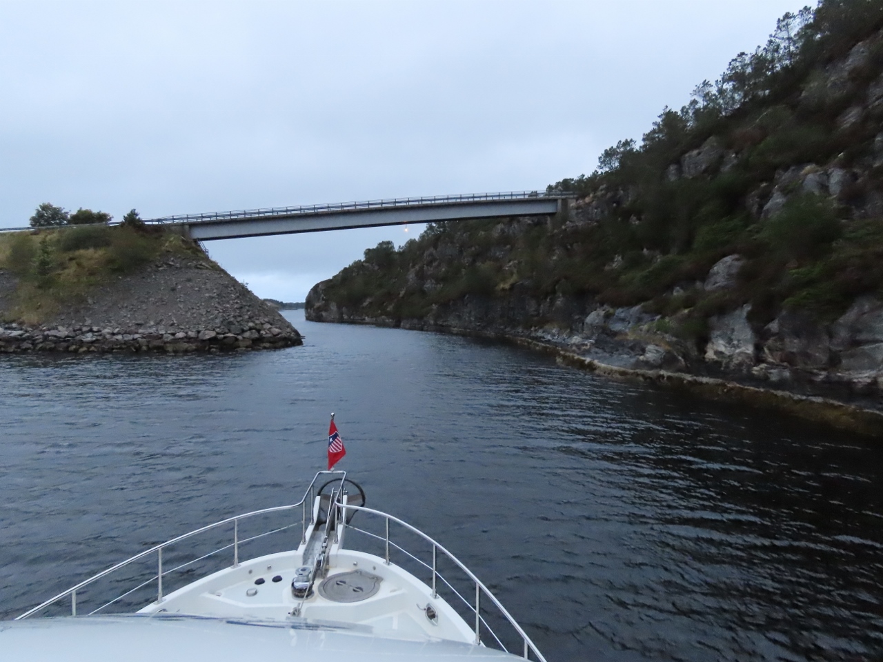
Hagelsund Bridge
Position: 60°32.75’N, 5°16.19’E
Looking back to the Hagelsund Bridge after we passed under it. This bridge, completed in 1982, and the combination pontoon and suspension Nordhordland Bridge, completed in 1992, together provided road service between Knarvik and Bergen.
|
 |
DOF Group
Position: 60°35.07’N, 5°10.38’E
Skandi Buchan, Skandi Foula, Skandi Barra and Skandi Rona moored at the RadoyGruppen fabrication facility. The vessels are part of DOF Group’s fleet of 67 purpose-built offshore vessels. It’s possible the ships are picking up parts at RadoyGruppen for delivery offshore, but more likely they are being stored here during the current oil industry downturn.
|
 |
Mjelkevika
Position: 60°36.45’N, 5°0.22’E
Looking towards the narrow and shallow marked entrance into Mjelkevika. We’d entered to consider anchoring there, but swing room inside felt too restricted. We instead anchored just to the west at Kalvetraevika.
|
 |
Trond and Margareth
Position: 60°36.44’N, 4°59.42’E
We first met longtime blog reader Trond Saetre and his partner Margareth Baartvedt at Bergen in 2018. He gave us excellent advice and local knowledge on that trip and has done the same this time around.
They happened to be out cruising nearby in their Nordstar Patrol 32 Ocean Star and stopped by to say hello. Since we weren’t planning a trip to Bergen this year, it was great to have an impromptu meeting, raft the two boats up, and catch up in person. This was our first view of a Nordstar boat up close—they are impressively well-designed and built. |
 |
Toskesundet
Position: 60°38.39’N, 4°59.11’E
Approaching the bridge across the narrows at Toskesundet between the islands of Toska and Flona. The charts indicate the clearance is 16m, plenty for our 9.1m air draft, but it looked quite low and was not marked with the clearance as is common for Norwegian bridges. We used our Nikon Forestry Pro Laser Rangefinder to confirm the charted clearance before passing under.
|
 |
Rough Water
Position: 60°42.01’N, 4°52.61’E
The north end of Hjeltefjorden is exposed to North Sea winds and waves. Conditions weren’t particularly bad given the past couple of days of northwest winds, but the waves were enough to almost completely obscure this small fishing boat running into head seas out of Kvolmosen.
|
 |
Maroystraumen
Position: 60°42.21’N, 4°53.41’E
We initially were planning to head through Maroystraumen and run along the east side of the island of Maroy, but we wouldn’t be passing under this 5.5m bridge.
|
 |
Radar
Position: 60°42.55’N, 4°51.79’E
Large radar array on the island of Maroy at the site of an old German World War II coastal defense station. The radar likely is a supporting station for the Vessel Traffic Center on the island of Fedje, seven miles to the northwest.
|
 |
Channel
Position: 60°43.92’N, 4°52.41’E
Running an intimate channel between islets at the north end of Hjeltefjorden.
|
 |
Wing On
Position: 60°44.20’N, 4°51.87’E
When we operating in constrained quarters, we run the wing engine in addition to the main (see Wing Tach near the top at right—click image for a larger view). We do this partly to have the wing readily available in case the main fails, but also to provide more hydraulic power to the thrusters should we need to use them.
|
 |
Kjerringastraumen
Position: 60°43.37’N, 5°5.74’E
Looking back through the narrows in the channel Kjerringastraumen that we just passed through. The channel is narrow and only 10ft deep, so entering against a strong outflow current was a tad exciting.
|
 |
Lindasstraumen
Position: 60°43.37’N, 5°5.75’E
Upwellings from the strong ebb current outside Lindasstraumen. We arrived about 2 1/2 hours after low water at Mongstad and the flow was still quite swift. We couldn’t find any current tables for Lindasstraumen, so temporarily anchored outside the channel to wait and watch for slack water. The flow eventually subsided about 3 1/4 hours after low water at Mongstad.
|
 |
Lindas Lock
Position: 60°43.38’N, 5°5.87’E
Lindasstraumen is the site of Norway’s second saltwater lock (the other is the Skjoldastraumen Lock that we visited a few weeks earlier). The lock basin is 108ft (33m) long, 24.6ft (7.6m) wide and 11.5ft (3.5m) deep and was opened in 1908 to serve the roadless communities inside. With the advent of roads in the area, the lock fell into disuse in the 1950s and the gates were left permanently open starting in 1963. A project was underway to restore the lock for recreational use, but appears to have stalled.
|
 |
Lock Gates
Position: 60°43.35’N, 5°5.97’E
Looking back to the lock gates as we pass through Lindas Lock at slack. Slack water seemed to last only about ten minutes before the flow turned to flood.
|
 |
Enclosure Temperature
Position: 60°43.18’N, 5°7.57’E
We installed a Maretron TMP100 temperature probe, circled in red, inside the generator enclosure to track the enclosure temperature.
|
 |
Valve Adjustment
Position: 60°43.19’N, 5°7.58’E
The wing engine was due for its 600-hour valve adjustment. Here James is turning the engine by hand to the correct position to adjust valve clearance. In the foreground you can see the wing engine hydraulic pump and, between it and the engine, the power take-off clutch.
|
 |
Generator Voltage
Position: 60°43.19’N, 5°7.57’E
We noticed the generator hit 254V today. This is only 6% above the nominal setting of 240V but it normally never exceeds about 243 to 244V so it caught our interest when we walked past the Maretron N2kview display.
|
 |
Gen Voltage Regulator
Position: 60°43.19’N, 5°7.57’E
Earlier today the generator hit 254V on it’s nominal 240V setting. It normally doesn’t exceed 243 to 244V. It’s not a problem at 254V but we like bigger safety margins so here James is adjusting the voltage regulator down from 243V at high idle to 230V. We’ll keep an eye on it since the generator output voltages seem to be wandering more than usual.
|
 |
Lindaspollene
Position: 60°43.06’N, 5°9.13’E
Underway on a short, five-mile run to a new anchorage in Lindaspollene for a change of scenery.
|
 |
Lindas
Position: 60°43.90’N, 5°9.55’E
The town of Linda, with the bridge across Haukasstraumen, seen on a tender tour of the area.
|
 |
Vagseidet
Position: 60°43.46’N, 5°12.72’E
Waterfall draining the lake Eidsvatnet into Fjellangsvagen at the town of Vagseidet.
|
 |
Roaren
Position: 60°43.52’N, 5°10.68’E
Mural Roaren by Italian artist Giuseppe Miconi on the side of a boathouse at the narrows in Haukasstraumen. It was created in 2014 as part of the inaugural “The Sea Park in Lindasosane”, an outdoor art exhibit viewable only by boat. The plan was to add an additional artwork each year.
|
 |
Rower
Position: 60°43.12’N, 5°6.56’E
Image of a rower, mounted just above the tide line near the Lindas Lock.
|
 |
Lindas Lock
Position: 60°43.38’N, 5°5.87’E
Looking into Lindas Lock from outside during a strong flood current. The water was really pouring through.
|
 |
Fish Artwork
Position: 60°43.32’N, 5°6.14’E
More artwork in Lindaspollene, this one with images of several different types fish mounted on a grating.
|
 |
Kommer Ikke Far
Position: 60°43.35’N, 5°8.38’E
Kommer Ikke Far? (Is Father Coming?) by artist Bente Brekke Kampevold of Lindas, part of the 2014 “The Sea Park in Lindasosane” exhibit. What an unexpected treat to find these art displays.
|
 |
Old Boat
Position: 60°41.96’N, 5°11.48’E
An old boat and a rusty motor, decaying on the shore in Lindaspollene.
|
 |
Utvaer
Position: 60°43.25’N, 5°9.25’E
The Norwegian Redningsselskaret (SAR) vessel Utvaer arriving into Lindaspollene on a pass through the area.
|
 |
Lindas Lock
Position: 60°43.39’N, 5°5.84’E
Departing Lindas Lock at low-water slack. The basin is 24.6ft (7.6m) wide, leaving about 5 feet on each side with our 16.4ft (5m) beam.
|
 |
Bow Watch
Position: 60°44.57’N, 5°2.72’E
Jennifer doing a bow watch, looking for dangerous rocks, as we enter the large basin north of Lindaspollene. The charts seemed a little short on detail here, with depths below 20ft, so we wanted to be extra careful coming in.
|
 |
Hull
Position: 60°43.76’N, 5°5.39’E
We came across this hull moored at the head of a sheltered channel south of the island of Brakoy. It’s been there long enough to show up on the satellite imagery.
|
 |
Hull Interior
Position: 60°43.75’N, 5°5.40’E
The interior of the hull we found was empty, with no transom.
|
 |
Dragsundet
Position: 60°43.73’N, 5°4.52’E
Passing under the low bridge in narrow Dragsundet. The whole area is ideal for exploration by tender.
|
 |
Flood Current
Position: 60°43.36’N, 5°5.93’E
Back at Lindas Lock to check out the strong flood current.
|
 |
Ram
Position: 60°44.14’N, 5°3.35’E
This unusual-looking ram followed us alongshore the entire way through Borsundet, stopping frequently to glare at us. We’re just glad it didn’t seem inclined to swim :).
|
 |
Verasstraumen Rapids
Position: 60°44.30’N, 5°5.34’E
In yesterday’s tender trip through Lindaspollene, we’d wanted to pass through Verasstraumen from south to north. But the charts show the area as drying at low water and the current was running hard when we arrived, making it difficult to carefully pick our way through and avoid rocks. Today we arrived at the north end with the current flowing even harder, and it looked pretty much impossible to pass through safely.
A local resident saw us eyeing the current and came over by boat, offering to show us the way through. He said we had to go fast, we we followed tight behind in an amazingly complicated little course around frequent obstacles, with Jennifer standing up to video the adventure. This video shows us returning from south to north, a little further behind our guide, the safe path running very close to the shore on each side. If you look carefully, you can see us shooting past rocks just below the surface, particularly near the bridge. |
 |
Sunset
Position: 60°44.16’N, 5°4.51’E
Beautiful sunset from our anchorage off the island of Brakoy.
|
 |
Click the travel log icon on the left to see these locations on a map, with the complete log of our cruise.
On the map page, clicking on a camera or text icon will display a picture and/or log entry for that location, and clicking on the smaller icons along the route will display latitude, longitude and other navigation data for that location. And a live map of our current route and most recent log entries always is available at mvdirona.com/maps. |
?Love these?
Thanks for the posts of the locations & the numerous tips????
Thanks for the feedback on the blog posts.