Today we set off from Seattle to do some longer-range cruising. Our goal is to cross over to Hawaii, and we’ll figure out the next step from there. Insurance restrictions discourage travel in the area between June and November, during the northern hemisphere hurricane season. May was too soon to leave, and we didn’t want leave Seattle and travel through the North Pacific in November during the winter storm season. So we’ll first be travelling to the San Francisco area to stay there temporarily for 4-6 weeks until we cross over to Hawaii in October. This also puts us 200 miles closer–Hawaii is about 2,200 miles from San Francisco and about 2,400 from the Seattle area. The prevailing winds and currents are better on this more southerly route as well.
|
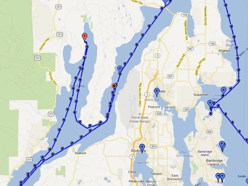
We’ve just finished a new feature on the web site that shows a real-time plot of Dirona‘s location. A small version of the live chart is on the blog site above, and a large one is at: http://www.mvdirona.com/maps/LocationCurrent.html. In the image at right (click to enlarge it), the blue line is the plot of our track. Each blue square on the line shows the time and speed at that location if you put the cursor on them. And the red square with the star shows our current location. The blue paddle icons represents a log entry along the way, the red one being the most recent. Click on a paddle to see details for that entry. Each map also has a refresh button that you can click to refresh just the map data (rather than the whole page). |
 |
.jpg) |
As we sail south, we’re leaving one of the most beautiful cruising areas in the world and perhaps the nicest marina we’ve ever stayed at. Bell Harbor Marina, in the core of downtown Seattle, is a special place. Below are some of what we’ve seen since our cruise on the Columbia and Snake River system. You also can display these on the map view. |
_small.jpg) |
05/18/12: Cap Sante Boat Haven, Anacortes
At Anacortes for Trawler Fest. We’ll be presenting Saturday morning.
|
_small.jpg) |
05/21/12: Pier 57 Ferris Wheel
The Pier 57 Ferris Wheel, still under construction, viewed from our moorage at Bell Harbor.
|
_small.jpg) |
05/27/12: Murden Cove
Landslide off our anchorage at Murden Cove. Shoring that up looks like an expensive operation.
|
_small.jpg) |
06/08/12: Hanjin Geneva
The Hanjin Geneva en route from Seattle, viewed from our anchorage at Murden Cove.
|
_small.jpg) |
06/15/12: Bell Street Classic Weekend
The classic wooden yacht Olympus coming alongside for the Bell Street Classic Weekend shortly before we left the marina for Murden Cove.
|
_small.jpg) |
06/18/12: Norwegian Pearl
When the cruise ships leave pier 66, you can almost touch them from the Edgewater Hotel patio.
|
_small.jpg) |
07/13/12: Rich Passage I
Kitsap Transit’s fast ferry Rich Passage I en route from Seattle to Bremerton.
|
_small.jpg) |
07/15/12: USCGC Stratton
The piracy threat level is probably about -2 at Bell Harbor today with the 418-foot US Coast Guard Cutter Stratton moored alongside.
|
_small.jpg) |
07/16/12: Into the fog
The US Coast Guard Cutter Stratton heading into a foggy Puget Sound this morning.
|
_small.jpg) |
07/20/12: Blakely Harbor
David Baker sent us this picture he took of Dirona anchored at Blakely Harbor with the Seattle skyline in the background.
|
_small.jpg) |
07/27/12: Silverdale
We’re anchored at the head of Dyes Inlet for Silverdale’s annual Whaling Days. The public dock is packed for the event.
|
_small.jpg) |
07/27/12: Fireworks
Friday-night fireworks at Silverdale’s Whaling Days. The show was impressive: we were only a few hundred yards away from the barge and felt like we were right underneath.
|
_small.jpg) |
07/28/12: The Joey James Dean Band
The Joey James Dean Band on stage Saturday night at Silverdale’s Whaling Days.
|
_small.jpg) |
07/31/12: Nearly-full moon
A nearly-full moon rising over the Seattle skyline next to the mast of the HMCS Oriole.
|
_small.jpg) |
08/01/12: Bringing in the colors
Bringing in the colors on the USS Halsey.
|
_small.jpg) |
08/05/12: On the TravelLift
Getting lifted for anti-fouling paint at Canal Boatyard.
|
_small.jpg) |
08/12/12: Racoons
Racoons gathering breakfast at low tide off Blakely Island. At least a dozen are out there.
|
_small.jpg) |
08/31/12: Fishers
Fishers packed Point No Point this morning. Even more are outside the picture frame.
|
_small.jpg) |
08/31/12: Sea monster
This driftwood sea monster has been on Pt. Hannon as long as we’ve been visiting Hood Canal.
|
_small.jpg) |
08/31/12: Hood Canal Bridge
Heading under the Hood Canal bridge. The clearance is 30′, but we had about 5′ to spare on a 7′ tide.
|
_small.jpg) |
08/31/12: Nightfall
The head of Hood Canal is a much cozier-feeling anchorage than the chart implies–we quite like it. We were here two years ago for July 4th and had a great time. A few small boats buzz about during the day, but nobody else is anchored–the place is calm and silent at night. And this time we had a visitor: Rachel, who co-owns one of the nearby houses, paddled out with a bottle of wine to introduce herself, and came on board for an enjoyable visit.
|
_small.jpg)
_small.jpg)
_small.jpg)
_small.jpg)
_small.jpg)
_small.jpg)
_small.jpg)
_small.jpg)
_small.jpg)
_small.jpg)
_small.jpg)
_small.jpg)
_small.jpg)
_small.jpg)
_small.jpg)
_small.jpg)
_small.jpg)
_small.jpg)
_small.jpg)
_small.jpg)
_small.jpg)
_small.jpg)
_small.jpg)
_small.jpg)
_small.jpg)
_small.jpg)
Thanks Keith! We’re pretty excited ourselves. We hit some weather earlier, but are now cruising under a clear blue sky and light swell a few hours out of San Francisco.
Jennifer
Bon Voyage, you two! This is exciting, we’ll be tracking your progress. Be safe.