In addition to the hiking and dramatic scenery, another draw of the Dolomites for us was the chance to do a via ferrata course where the sport originated. Via ferrata means “iron road” in Italian, and refers to a system of cables, ladders, bridges, handholds, and footholds used to aid ascension. The first recreational course of this nature was built in Austria in in the mid-1800s, but they are most closely associated with World War I Italy. In the peaks and passes of the Dolomites, Italy and the Austro-Hungarian Empire established extensive trenches and tunnels in their 30-month high-altitude battle for control of the area. To navigate the steep and difficult terrain, they carved holding aids into the rocky face and installed a network of cables, ladders and bridges.
Decades later, local Alpine clubs upgraded these courses, replacing rope with steel cable, and flimsy wooden ladders and holding aids with iron ladders and rungs. The sport has been rapidly gaining in popularity, with currently over 4,000 courses worldwide. Austria has the most, with over 550, and Italy has over 400, with at least half in the Dolomites. They vary in degree of difficulty, with some taking as long as nine or ten hours to complete.
On our trip to the Dolomites, we selected the Via Ferrata Gianni Aglio. The route had spectacular views, was easily accessible by cable car from Cortina and would take about 4 hours roundtrip. We had a fabulous time, but it was definitely the most difficult via ferrata we’ve undertaken, and at about, or possibly exceeding, our comfortable risk limit.
We took the cable car up to Ra Valles at an altitude of 8,100 ft (2,470m), and from there hiked and scrambled up to the start of the via ferrata course at 9,500 ft (2,900m). This part of the route wasn’t very obvious or well-marked, but a rough AllTrails route got us in the right path.


The via ferrata also can be reached from two longer routes via cable cars farther west. After seeing few, if any, people along our path from Ra Valles, we joined a constant stream of climbers who had followed the other routes. Intermittent clouds blocked some of our views at this initial part of the course, but made for an interesting experience as the visibility varied.


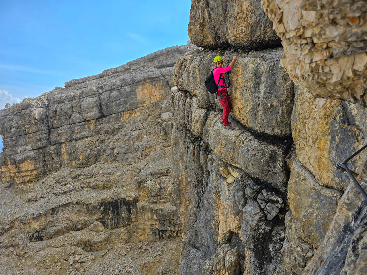
The first challenging part of the course came after we crossed a short ridge between two steep faces and reached a cable snaking up the second face. The person in front of us was really struggling to ascend and we thought they were being a little slow until we got onto the face ourselves. The way was pretty much straight up, with few foot holds, and we had to just pull ourselves up with arm strength.


That was difficult, but the most challenging part of the route lay just ahead. At the Torre Gianni Aglio (Gianni Aglio Tower), a horizontal cable led around the face above an overhang hundreds of feet above the ground. We had only the cable to hold onto and a crack in the tower face to support our feet as we shuffled along, hanging out around the ledge. If we dared to look down, the terminus of the Bus Tofano chair lift was visible far, far below. This section definitely had our full attention.


We made it around the face, and the clouds began to clear considerably as we continued, giving us some of the great views we’d been expecting. We still had several difficult sections to traverse, but they felt relatively tame after negotiating the Torre Gianni Aglio.


We reached the famous Bus de Tofana (Hole in the Tofana) about 2.5 hours from Ra Valles. The window in the rock marks the start of a popular backcountry ski route. After snowshoeing at Mt Baker, we’re amazed at the difficult terrain some skiers will take on.


The remainder of the route included more ladders than earlier, to manage the steeper ascent, and much spectacular scenery.
We arrived happy and satisfied at the summit of Tofana di Mezzo, at 10,644ft (3,244m) the third-highest peak in the Dolomites. The clouds had come back a bit, but the views still were absolutely amazing. After lunch at the Bar Cima Tofana, we took the cable car back down to Ra Valles and on to Cortina.


We really enjoyed the Via Ferrata Gianni Aglio, and are glad to have completed the course. It was a real adventure, and the scenery truly was spectacular. We’ll definitely do more via ferrata courses, but with this one rated a difficulty level of 4 on a scale of 1 to 5, where 1 is very easy, we’re not eager to try a 5.
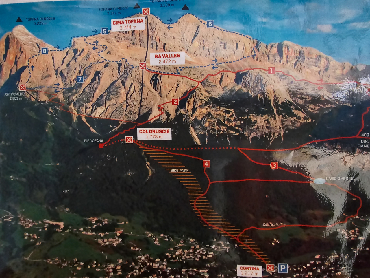
The photo below shows our route. From Cortina at bottom right, we took a cable car up to Col Druscie at center and another to Va Ralles near the top at center. From there we followed the blue dashed line leading left and up, eventually labelled with a ‘5’, to Tofana di Mezzo (at the very top above Cima Tofana) center. The total elevation gain from Va Ralles to Tofana di Mezzo was 2,532 ft (772m) over a distance of 3.25 miles (5.2km) in 3.5 hours.
If your comment doesn't show up right away, send us email and we'll dredge it out of the spam filter.