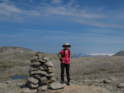
The five-hour return hike to 3,300ft (1,005m) Mjelkhaug is a combination of two other hikes: a three-hour circular loop to Nordjfell, with a one-hour extension to Varhaugselet and an additional hour to reach Mjelkhaug. All three hikes have excellent views west into Hardangerfjorden, while from Mjelkhaug you also can see the Folgefonna glaciers.
On another warm and sunny day, we ran the tender three miles from the anchorage at Morkavegen to Valen, and walked a half-hour to the trailhead. Besides the great views, we also enjoyed having a look at the wonderful mountain cabins at Varhaugselet and closer to the bottom at Olderbotn.
Below are highlights from August 11th, 2020. Click any image for a larger view, or click the position to view the location on a map. And a live map of our current route and most recent log entries always is available at mvdirona.com/maps.
 |
Morning Calm
Position: 59°48.42’N, 5°40.59’E
Wonderfully calm morning looking east at dawn from the anchorage at Morkavegen.
|
 |
Tender
Position: 59°49.63’N, 5°47.20’E
The tender tied off at the Valen pier for our hike up to Mjelkhaug.
|
 |
Valen
Position: 59°49.63’N, 5°47.20’E
At the Valen pier, where we tied off the tender.
|
 |
Trailhead
Position: 59°50.02’N, 5°47.58’E
At the trailhead to Mjelkhaug, about a half-hour walk from the tender.
|
 |
Trail Map
Position: 59°50.02’N, 5°47.58’E
Mjelkhaug is the farthest destination with several view points along the way, allowing shorter hike with a loop if desired. We’ll be heading up the north arm, then back on the south arm of the loop.
|
 |
Kattnakken
Position: 59°50.66’N, 5°47.60’E
View to the TV tower on Stord from the trail to Mjelkhaug at altitude 1573 ft (479 m).
|
 |
View
Position: 59°50.70’N, 5°47.66’E
An impressive view east from a bluff at 1641 ft (500 m).
|
 |
Nordfjellet
Position: 59°50.85’N, 5°47.88’E
Looking east at an altitude of 1837 ft (560 m) from Nordfjellet en route to Mjelkhaug. Dirona is just visible as a white speck amongs the islands at the upper left of the picture (click image for a larger view).
|
 |
Hydro Husnes
Position: 59°50.85’N, 5°47.88’E
The massive Hydro Husnes aluminum smelter stretches nearly halfway across the picture.
|
 |
Meadow
Position: 59°50.97’N, 5°48.25’E
Crossing a boulder-strewn meadow at altitude 1779 ft (542 m), halfway to 3,300ft (1005m) Mjelkhaug, visible in the background. We found an alternate marked trail that allow us to walk a full loop nearly all the way to the summit with minimal retracing of our steps.
|
 |
Break
Position: 59°51.68’N, 5°50.07’E
Taking a break at altitude 2740 ft (835 m).
|
 |
Mjelkhaug
Position: 59°51.86’N, 5°50.88’E
At the summit of 3,300ft (1005m) Mjelkhaug, with the Folgefonna glaciers visible in the background. We’re getting closer to them on each hike.
|
 |
Lunch
Position: 59°51.83’N, 5°50.87’E
A picnic lunch with a view at the summit of Mjelkhaug.
|
 |
Lake
Position: 59°51.83’N, 5°50.87’E
The landscape up here is dotted with small lakes, with the huge interior mountains visible beyond.
|
 |
Rocks
Position: 59°51.41’N, 5°50.08’E
The landscape is full of striking rock formations as we descend from Mjelkhaug on the eastern arm of the loop.
|
 |
Vardhaugen
Position: 59°51.01’N, 5°49.40’E
The cairn marking the viewpoint at Vardhaugen at altitude 2462 ft (750 m).
|
 |
Vardhaugselet
Position: 59°51.01’N, 5°49.40’E
Looking down to the mountain cabin at Vardhaugselet from Vardhaugen.
|
 |
Vardhaugselet Cabin
Position: 59°51.00’N, 5°49.14’E
The beautiful interior of the cabin at Vardhaugselet, maintained by the Norwegian Trekking Association for public use.
|
 |
Olderbotn
Position: 59°50.36’N, 5°48.43’E
Another Norwegian Trekking Association cabin at Olderbotn at altitude 1256 ft (383 m).
|
 |
Olderbotn Cabin
Position: 59°50.36’N, 5°48.43’E
Inside the cabin at Olderbotn. The Norwegian Trekking Association really does a wonderful job with these mountain cabins.
|
 |
Descending
Position: 59°50.38’N, 5°48.38’E
Descending through forest at 1250 ft (381 m).
|
 |
Umbrella
Position: 59°48.41’N, 5°40.58’E
Escaping the “blistering” Norwegian sun under a patio umbrella. Jokes aside, we’re still really hot from our 7-hour hike up Mjelkhaug and southern Norway is experiencing near-record temperatures. It’s currently 80°F (26.7°C). Even heat-loving Spitfire is enjoying the shade.
|
 |
Evening Calm
Position: 59°48.43’N, 5°40.60’E
An ultra calm evening in the anchorage at Morkavegen (clockwise from top left: looking forward, aft, starboard and port).
|
 |
Click the travel log icon on the left to see these locations on a map, with the complete log of our cruise.
On the map page, clicking on a camera or text icon will display a picture and/or log entry for that location, and clicking on the smaller icons along the route will display latitude, longitude and other navigation data for that location. And a live map of our current route and most recent log entries always is available at mvdirona.com/maps. |

If your comment doesn't show up right away, send us email and we'll dredge it out of the spam filter.