For the 207nm run from Southampton to London, we were planning to stop for the night in Queenborough off the mouth of the Thames before continuing to London the following morning. This would avoid a night running up the Thames. But we made much better time than expected, arriving at the Thames mid-morning, so continued through to London. We arrived just past dusk and stopped for the night at Hermitage Moorings with an incredible view to Tower Bridge and the Shard. We had a wonderful run up the Thames and were incredibly excited to finally reach London.
Below are trip highlights from February 8th and 9th between Southampton and London. Click any image for a larger view, or click the position to view the location on a map. And a live map of our current route and most recent log entries always is available at mvdirona.com/maps
 |
Rampion Windfarm
Position: 0 23.32, 50 37.27
We passed the Rampion Windfarm around 11pm. Construction began in 2015 and the facility is expected to come online this year with a target capacity of 400 MW. The windfarm is massive, the largest we’ve seen, at six miles across. Our charts don’t show the windfarm because it’s so new, but it’s pretty hard to miss, even at night. The towers are super visible on radar, plus they’re well-lit and the farm has two virtual AIS targets at the northwest and southwest corners.
|
 |
Roll
Position: 0 23.12, 50 37.26
Winds have been steady in the high twenties for the past four hours and we’re taking big waves on the beam. We just took our biggest roll of the run at 24.7° The boat is doing fine, but you really have to be careful moving around.
|
 |
Prime Meridian
Position: 0 0.19, 50 38.54
We just crossed the Prime Meridian, and we’ll cross back again when we near London. We haven’t seen an east latitude since we crossed the Prime Meridian two years ago en route to St. Helena from Cape Town.
|
 |
Traffic
Position: 0 14.10, 50 39.37
There’s a lot of traffic in the English Channel to our south as we round Beachy Head. We’re running north of the traffic lanes, shown in purple, to keep a good two miles away from other ships. The blue crosses at the end of the blue lines show where the CPA (closest point of approach) between us and each ship will be given current speed and course. It’s a new feature of our chartplotter, TimeZero, that we find really useful.
|
 |
Cliffs of Dover
Position: 1 24.13, 51 7.96
The South Foreland lighthouse barely visible on the White Cliffs of Dover about a mile away on an overcast morning. The light went into service in 1843 and was deactivated in 1988.
|
 |
Seas
Position: 1 26.05, 51 11.07
The heavy seas continued all night. We were hoping they’d settle down as we turned into Trinity Bay and put the winds more behind us, but it’s still pretty rough out there.
|
 |
North Foreland
Position: 1 28.01, 51 21.97
The North Foreland lighthouse, built in 1691 above the cliffs at Broadstairs, is a twin to the South Foreland lighthouse at Dover.
|
 |
Kentish Flats
Position: 1 8.21, 51 28.87
The Kentish Flats Windfarm is one of four windfarms in the Thames Estuary. The first phase was completed in 2005, with a capacity of 90 MW from 30 Vestas V90-3MW wind turbines. In 2015, 15 Vestas V112-3.3MW we added, increasing total capacity to 140 MW.
|
 |
Red Sands Forts
Position: 0 59.54, 51 28.94
The Red Sands Forts were one of armed tower fort groups built along the Thames and Mersey River estuaries to defend the UK from German air attacks during World War II. We’d initially planned to divert to Queensbourough for the night, as we didn’t expect to arrive at the Thames estuary until late afternoon. But we made excellent time overnight and arrived by ten in the morning. We decided we could reach London by dusk, and continued up the Thames.
|
 |
Norsky
Position: 0 57.45, 51 28.91
We’re seeing plenty of ship traffic as we enter the Thames River. This is the 590ft (180m) RO-RO Norsky heading to sea.
|
 |
BW Jaguar
Position: 0 33.14, 51 30.29
The 600ft (183m) oil tanker BW Jaguar moored at Canvey Island.
|
 |
Sertao
Position: 0 23.61, 51 27.05
The 744 (277m) drill ship Sertao is capable of drilling to depths of 40,000 ft (12,000m) in water depths of up to 10,000 ft (3,000m).
|
 |
QE II Bridge
Position: 0 15.24, 51 28.05
We just passed under the Queen Elizabeth II Bridge, completed in 1991 as part of the Dartford-Thurrock River Crossing. The crossing, that includes two tunnels, is the only fixed crossing of the Thames and carries a daily average of over 130,000 vehicles. When we passed at 3:40pm, the bridge already looked plugged solid with truck traffic.
|
 |
Littlebrook Power Station
Position: 0 15.03, 51 28.13
The Littlebrook D Power Station is the last of four oil and coal-fired power stations built just west of the Queen Elizabeth II bridge. The oil-fired station first operated in 1981 and ceased operating in 2015 due to the EU Large Combustion Plant Directive aimed at reducing with air pollutants from the combustion of fossil fuels.
|
 |
Riverside Resource Recovery
Position: 0 9.15, 51 30.67
The massive Riverside Resource Recovery waste incinerator burns garbage to produce electricity.
|
 |
Crossness Sewage Treatment Works
Position: 0 8.89, 51 30.74
The Crossness Sewage Treatment Works is one of the largest in Europe. The modern sludge-powered generator went into operation in 1998 and can produce up to 6 MW of energy, three-quarters of the plant’s requirements.
|
 |
London!
Position: 0 8.17, 51 30.93
The London skyline coming into view as we round the bend at Thamesmead. We’re so excited to actually be here.
|
 |
Construction
Position: 0 4.04, 51 29.85
We’re seeing lot of construction along the river as we near London. The economy seems to be booming.
|
 |
Tidal Barrier
Position: 0 3.23, 51 29.82
The Thames Tidal Control Barrier visible in the distance. The barrier prevents flooding of the Greater London due to high tides and storm surges. Vessels intending to pass through must radio in advance for permission and instructions from London VTS (Vessel Traffic Service). Green arrows on the piers indicate the spans open for passage. We’d been assigned span E, the rightmost of the two open spans.
|
 |
Control Center
Position: 0 2.19, 51 29.84
The control center monitors all traffic passing through the barrier.
|
 |
Passing Through
Position: 0 2.19, 51 29.84
Dirona passing through the Thames Tidal Control Barrier.
|
 |
Rotating Gate
Position: 0 2.19, 51 29.84
The Thames Tidal Control Barrier has semi-circular gates that lies on the river bottom and rotate into place when needed.
|
 |
Cable Car
Position: 0 0.88, 51 30.07
A cable car crossing the Thames opened in 2015 and carries passengers for a distance of 3,600ft (1,100 m) at a maximum elevation of 300ft (90m) above the river. It’s definitely in our to-do list while visiting London.
|
 |
O2 Arena
Position: 0 0.14, 51 30.42
The O2 Arena can hold 20,000 people, the second highest seating capacity in the UK. The arena is named after it’s primary sponsor, the telecommunications company O2.
|
 |
Greenwich
Position: 0 0.52, 51 29.15
The magnificent Old Royal Navy College buildings at Greenwich are part of Maritime Greenwich, a UNESCO World Heritage Site. The buildings initially were erected in 1692 as the Royal Hospital for Seamen at Greenwich. In 1873, they were converted to a training facility for the Royal Navy, who occupied the site until 1998. Part of the The University of Greenwich now occupies part of the site.
|
 |
Sunset
Position: 0 0.52, 51 29.15
A striking sunset as we near London. The light is fading, but we’re close now.
|
|
|
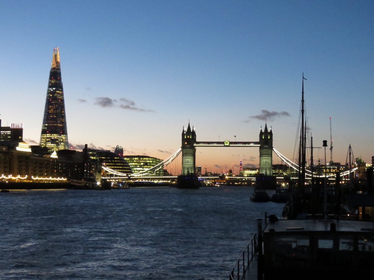
Tower Bridge
Position: 0 3.98, 51 30.21
We’ve arrived and are docked along the River Thames for the night with a view to Tower Bridge. Wow!
|
 |
Moored
Position: 0 3.99, 51 30.21
Our ultimate destination is St. Katharine Docks, but the it’s behind a lock and the next opening is tomorrow morning. So we stopped for the night at the Hermitage Community Moorings. We’re so excited to be here.
|
 |
River Thames
Position: 0 3.88, 51 30.23
Looking across the River Thames with our berth at the left end of the Hermitage Community Moorings in the foreground and Tower Bridge visible on the right. Left of the bridge is The Shard, a 1,017 ft (310 m ) skyscraper complete in 2012. The observation deck atop the tower is also on our London to-do list.
|
 |
Town of Ramsgate
Position: 0 3.74, 51 30.22
Dinner at our first London pub, the Town of Ramsgate along the Thames. It’s awesome to be here.
|

|
Click the travel log icon on the left to see these locations on a map, with the complete log of our cruise.
On the map page, clicking on a camera or text icon will display a picture and/or log entry for that location, and clicking on the smaller icons along the route will display latitude, longitude and other navigation data for that location. And a live map of our current route and most recent log entries always is available at mvdirona.com/maps. |
If your comment doesn't show up right away, send us email and we'll dredge it out of the spam filter.