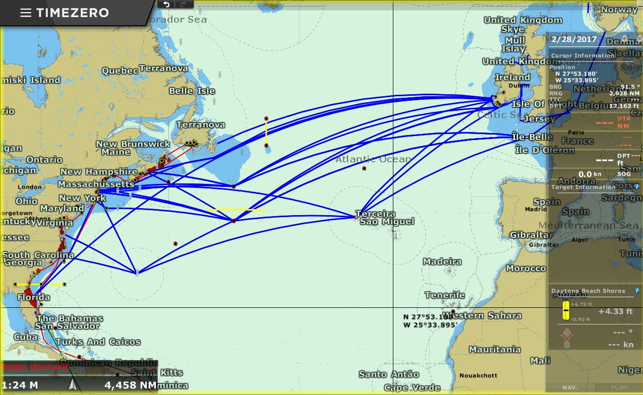
While in Florida earlier this year, we considered a variety of routes for our upcoming Atlantic passage. Some of the possibilities are shown in the screenshot above (click image for larger view). The waypoint east of South Carolina is Bermuda, and the one labeled Terceira Sao Miguel is the Azores. The other waypoints are mostly from Jimmy Cornell’s World Cruising Routes and are for avoiding hazards or picking up favorable conditions:
- The one closest to New York is to clear Nantucket Shoals and the one south of Newfoundland is to clear the Grand Banks.
- The two waypoints just east of Nova Scotia and the one south of the horizontal yellow line are for ice avoidance. And the yellow lines near Newfoundland are the ice pack extent in May of 2016 using the International Ice Patrol iceberg charts (the most current chart is here). If we were departing from Nova Scotia with no ice, we could continue from the Nova Scotia waypoint to the Grand Banks waypoint. Otherwise we should proceed to waypoint below the yellow line before turning eastward.
- The waypoint about 350 miles north of the Azores is from Cornell’s Ocean Atlas and is for avoiding low pressure systems coming off Nova Scotia. Cornell’s recommendation there is stay south of 45N until east of 30W.
- The waypoint 350 miles northeast of Bermuda is for getting into the prevailing winds as quickly as possible on a departure from Bermuda to Northern Europe.
- The yellow bar down by Florida is the hurricane restriction line for our boat insurance. We’re not covered for named storms south of that line between July 1st and October 31st.
Ideally we’d run the northernmost route, 1,700nm from Newfoundland to Ireland, but would have to wait until at least July if not August for the icebergs around Newfoundland to clear. For a direct run between the US and Ireland that avoids the ice risk, Newport RI and area is the closest point of departure. But the 2,950nm run will put us in the North Atlantic for three weeks, a long time to go without seeing a major low pressure system, so we’d need a backup plan in case a major system develops during the crossing.
We ended up deciding to depart from Newport, and the screenshot below shows our updated potential routes now that we’re there. Our current plan is to leave in early May with the needed fuel for the 2,950 miles. We’ll make a decision to proceed to Cork directly, or to the Azores, based on the weather report a week or ten days in.
On the screenshot below, the new turquoise boundary line is the ice extent as of April 6th, and we’ve drawn two new routes that run just south of that line. Ideally we’d take one of them, but this year is unusually bad for ice (link via Steve Dashew), so likely by May the ice extent will be even further south and we’ll need to run at least below the horiontal yellow line, if not as far south as Cornell’s ice-avoidance waypoint.
The alternate routes shown are suprisingly similar in distance. The first part of the route from Newport, via the ice-avoidance waypoint, is nearly identical whether going to Cork directly, or via the Azores. The direct Great Circle route to the Azores from Newport is 2,000nm compared to 2,010nm via the ice-avoidance waypoint.
Beyond that point, the routes don’t differ that much. The 1,940nm run from the ice-limit waypoint to Cork via the storm-avoidance waypoint takes us only 400 miles north of the Azores for a total passage distance of 2,950nm. Between those two waypoints we can divert to the Azores should a large weather system appear to be developing. The northernmost route shown below is the great circle route directly from the April 6th ice limit to Cork. This route is 2,835 miles, saving only about 115 miles over the route via the ice- and storm-avoidance waypoints.
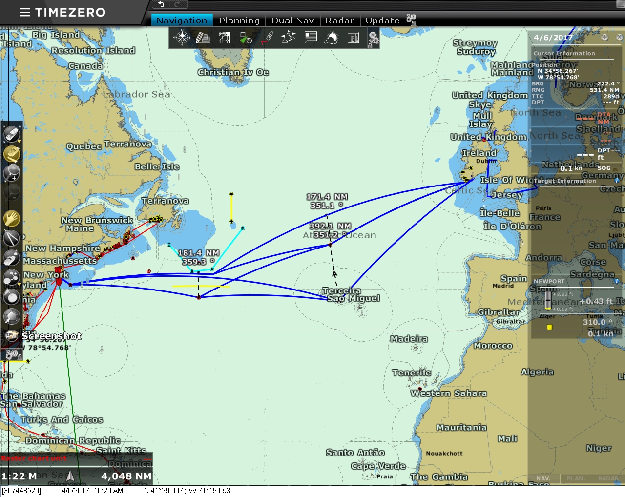
We’ve been told the Azores are beautiful and not to be missed, so why even consider a direct passage and not just plan to stop in the Azores? Part of the reason is we want to spend as much time as possible cruising the west coast of Ireland in May and June. We also prefer not to stop mid-passage if we don’t need to. Stopping takes time and has the additional overhead of clearing in and out of the country. And the direct run to Cork via the ice- and storm-avoidance waypoints is more direct: 2,950 miles versus 3,190 via the Azores, a difference of 240 miles, or more than a day at sea.
For your information – came across this article today
http://gcaptain.com/record-numbers-icebergs-swarm-north-atlantic-shipping-lanes/
Trust you are aware of the situation.
Best regards/Erik Andersen
Erik, appreciate your sharing that link. We’d love to see the icebergs, but not on this run. We’ve been monitoring the ice location via the International Ice Patrol’s charts showing the ice-bounds (today’s is at http://www.navcen.uscg.gov/?pageName=iipCharts&Current). The extent of the ice is much worse this year than last. This time last year the southern bound was north of 45N, today it is 41N. That’s almost as far south as the extreme it was last year in late June, but two months earlier. Hopefully we can cross before it gets too much farther south this year.
— Jennifer
Hi there James and Jennifer,
Great blog! Only recently discovered through Passagemaker but i am rapidly catching up!
Being a Grand Banks 36 owner and also having recent involvement building a Data Centre i find it all fascinating.
In a former life i did some off shore commercial fishing based out of west Cork so know that coast well. Where do you plan to make land fall? Kinsale would seem the most logical to me.
I’m based in L:ymington now, Uk south coast, so if you are passing drop in for a Solent tour on the GB.
Fair winds.
Declan.
If you like both boating and data centers, we do have a lot in common. Thanks for the tip on Kinsale. Our current plan is to check into Cork but we do expect to stop in Kinsale as well. Thanks,
Declan, you “caught” our interest and we have decided to land at Kinsale rather than Cork. The location is slightly better but, more important, the marina is closer to town and Kinsale looks like a very cool town. Thanks very much for the advice.
Hope you guys have an uneventful run to to the Irish. Along the same line as Andy’s question, wondered if you have tried the “predictwind” weather tool?
Predictwind is amongst the most popular of the commercial offerings in use. We did experiment with it a few years back but ended up continuing to just consult the NOAA WW3 and GPS weather models, coastal forecasts of the country we are currently in and, when doing longer crossings, we look at both the surface analysis and 500 mb data.
Lows can pop up quickly along your route to Cork. What weather forecasting resources do you use?
Yes, we agree. The North Atlantic weather systems can build rapidly and they can be violent. The best possible answer to reduce magnitude and frequency of weather systems is to leave closer to the summer but we would like to do some summer cruising in Europe this year.
The weather resources we use are pilot charts showing conditions, frequency, and magnitude by month over recorded history. Daily we consult the NOAA WW3 and GPS weather models. We also consult coastal forecasts of the country we are currently in and, when doing longer crossings, we look at both the surface analysis and 500 mb data. The problem with attempting to predict weather conditions is even the best predictions can’t look out 3 weeks with any reliability.