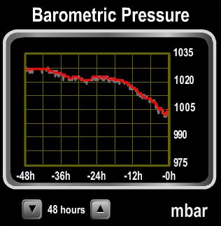
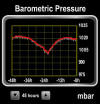
On Christmas Day, the barometer fell nearly 20mb in 24 hours and Environment Canada was predicting big weather: Storm warning in effect for West Coast Vancouver Island South. Wind west 25 to 35 knots diminishing to northwest 15 to 25 early this evening then backing to southwest 15 to 25 late this evening. Wind increasing to south 25 to 35 before Monday morning and to 35 to 45 near noon Monday except 50 northwest of Estevan Point. Wind becoming southwest 30 to 40 Monday evening. We actually were looking forward to it–no storm-force winds have hit Barkley Sound since we’ve arrived, and we were curious what conditions would be like. The storm didn’t turn out to be quite as fierce as predicted, but we did get some interesting barometer movement. Here’s our log from Snug Basin to Turtle Bay, or you can display them on the live map view. 
_small.jpg)
_small.jpg)
_small.jpg)
_small.jpg)
_small.jpg)
_small.jpg)
_small.jpg)
_small.jpg)
_small.jpg)
_small.jpg)
_small.jpg)

Previous log post for this trip: Julia Passage and Snug Basin
Christmas Cruise 2011: After the storm
12/23/11: Misty skies, Snug Basin
A heavy rain shortly after dawn has given way to a calm, misty morning. The temperature is much warmer today than yesterday–in the high 40s up from the low 30s.
12/23/11: Entering Poett Nook
The channel into Poett Nook looks tight, but is reasonably wide and deep.
12/23/11: Robbers Passage
We’re anchored off the Port Alberni Yacht club outstation, all closed up for the winter.
12/23/11: Tzartus Island
Abandoned house at the north end of Tzartus Island. It looks like it once was quite nice.
12/23/11: Shahowis Lodge
The Lodge at Shahowis appears to have been in disuse for several years. The dock was a mess, and it was pretty overgrown. Sad to see.
12/23/11: Sea arch, Tzartus Island
Small craft apparently go through this arch in calm conditions, but we didn’t have those today.
12/23/11: Sea cave, Tzartus Island
The exposed outer coasts in Barkley Sound are full of storm-created sea arches and caves like this one.
12/24/11: Bamfield Coast Guard Station
The Bamfield Coast Guard station also is home to the Rigid Hull Inflatable Operator Training (RHIOT) school. RHIOT operates only in the winter, when the weather is at its worst. Students from all over North America attend, learning how to operate the craft in extremely rough seas, including handling capsizes. The title of a Pacific Yachting article written by one attendee pretty much sums it up: “Getting Bashed at Bamfield.”
12/24/11: Air draft
We last were at the head of Bamfield Inlet in the previous boat. With an air draft of 15.5′, the 17m clearance under the wires between Burlo and Rance islands wouldn’t have been much of a concern. At 30.5′, the 52’s air draft leaves plenty of room to pass under, but it still caught our attention.
12/25/11: Entering Grappler Inlet
At the mouth of Grappler Inlet. This may look tight, but its nothing compared to where we’re heading.
12/25/11: Narrows at Grappler Inlet
Looking back through the marked channel we just passed through. The channel is narrow and shallow–charted depths are less than a meter in parts.
12/26/11: Turtle Bay
The more common entry is from the north, but the east entry appeared straigtforward and it was. We saw min 38′ on a 12′ tide.
_small.jpg)
_small.jpg)
_small.jpg)
_small.jpg)

_small.jpg)
%20(800x600)_small.jpg)
_small.jpg)

_small.jpg)


If your comment doesn't show up right away, send us email and we'll dredge it out of the spam filter.