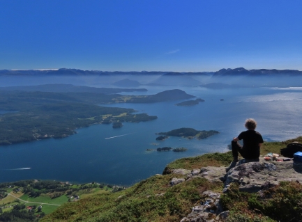
Hovlandsnuten soars 2,385ft (727m) nearly straight up along the east shore of the island Tysnes. On a beautiful, sunny day, we made a four-hour run from Etnefjorden and anchored directly below the mountain. A quick tender ride brought us ashore and we were at the top within two hours. The view isn’t apparent until the summit, where it suddenly opens up. And what a view it was. We could see Dirona anchored directly below and got a yet-closer sighting of the Folgefonna Glaciers, 22 miles (35km) away.
Below are highlights from August 15th, 2020. Click any image for a larger view, or click the position to view the location on a map. And a live map of our current route and most recent log entries always is available at mvdirona.com/maps.
 |
Kattnakken
Position: 59°54.56’N, 5°40.73’E
View in the distance to the TV tower on Kattnakken, where we hiked about a week ago, while underway for the anchorage at Sandsoya.
|
 |
Sandsoya
Position: 60°0.25’N, 5°42.55’E
Anchored at the island of Sandsoya off Tysnes, with 2,385ft (727m) Hovlandsnuten in the background. We’ll be hiking up to the summit shortly.
|
 |
Tender
Position: 60°0.33’N, 5°41.71’E
The tender moored at Tveit for the hike up Hovlandsnuten.
|
 |
Trailhead
Position: 60°1.32’N, 5°41.17’E
The trailhead at Skaret for the hike up Hovlandsnuten, about a half-hour walk from the tender at altitude 514 ft (156 m).
|
 |
Destination
Position: 60°1.34’N, 5°41.12’E
Our destination, the summit of 2,385ft (727m) Hovlandsnuten, from partway along the trail.
|
 |
Waterfall
Position: 60°1.30’N, 5°40.96’E
Waterfall spilling down a cliff along the trail up Hovlandsnuten.
|
 |
Rock
Position: 60°1.30’N, 5°40.43’E
Those glaciers moved some really big rocks.
|
 |
Vasstolstjodno
Position: 60°1.27’N, 5°40.15’E
Enjoying the view across the lake Vasstolstjodno, complete with a Summer Fun boat.
|
 |
Climbing
Position: 60°1.05’N, 5°40.10’E
Pulling ourselves up some of the steeper parts of the trail up Hovlandsnuten.
|
 |
Tysnes
Position: 60°1.03’N, 5°40.12’E
The view north across the island of Tysnes from altitude 1723 ft (525 m).
|
 |
Hovlandsnuten
Position: 60°0.89’N, 5°40.63’E
At the summit of 2,385ft (727m) Hovlandsnuten. The hike was short, only 1:20 from the trailhead and 1:45 from the tender, but a little tiring since we gained so much altitude in a short distance.
|
 |
Lunch
Position: 60°0.89’N, 5°40.64’E
Lunch with a spectacular view east on the summit of Hovlandsnuten. Dirona is the small white dot anchored in the islands below, directly to James left. The bright white strip atop the mountains at far left is the Folgefonna glaciers visible that we’ve been getting closer to on each hike.
|
 |
Hardangerfjord Express
Position: 60°0.89’N, 5°40.64’E
The Hardangerfjord Express underway from Bergen to Rosendal in Hardangerfjord.
|
 |
Tveit
Position: 60°0.90’N, 5°40.65’E
View to Tveit from the summit of Hovlandsnuten. Dirona is anchored among the island group just left of center and the tender is on the dock to the right of center.
|
 |
View North
Position: 60°0.92’N, 5°40.62’E
Panoramic view north across Tysnes from the summit of Hovlandsnuten (click image for a larger view). Our anchorage is just barely in sight on the right and the Folgefonna glaciers are prominent slightly right of center (click image for a larger view).
|
 |
Cabins
Position: 60°0.92’N, 5°40.61’E
Mountain cabins on Tysnes as we hike from Hovlandsnuten towards the radio tower atop 2,467ft (752m) Tysnessata.
|
 |
Tysnessata
Position: 60°0.67’N, 5°39.45’E
Radio tower at the summit of 2,467ft (752m) Tysnessata.
|
 |
Hikers
Position: 60°0.67’N, 5°39.45’E
Looking back to the summit of Hovlandsnuten from Tysnessata. The hike is incredibly popular, with a constant stream of people arriving while we were there.
|
 |
Svinadalen
Position: 60°0.34’N, 5°40.50’E
Two trails lead up to Hovlandsnuten, with similar distance from our tender. So we came down the other way, past the mountain cabins at Svinadalen.
|
 |
John Deere
Position: 59°59.66’N, 5°40.91’E
Another John Deere sighting in the wild. Nothing runs like a Deere!
|
 |
Bale Wrapper
Position: 60°0.35’N, 5°41.59’E
We loved seeing this bale wrapper in action. The machine works the field until it has a bale-full of product, then the back opens and the bale is rotated while the plastic wrap holders on either swing out and wrap the bale. When wrapped enough times, the bale is ejected, the lid closes and the next bale is started.
|
 |
Bale Wrapped
Position: 60°0.36’N, 5°41.59’E
After the bale was dropped, another tractor picked it up and carried it away.
|
 |
Evening Calm
Position: 60°0.27’N, 5°42.52’E
Evening calm in the anchorage at Sandsoya (clockwise from top left: forward, aft, starboard and port).
|
 |
Click the travel log icon on the left to see these locations on a map, with the complete log of our cruise.
On the map page, clicking on a camera or text icon will display a picture and/or log entry for that location, and clicking on the smaller icons along the route will display latitude, longitude and other navigation data for that location. And a live map of our current route and most recent log entries always is available at mvdirona.com/maps. |

Although you have posted lots of stunning photographs from your cruising and hiking in Norway, I think the photo titled “lunch” overlooking Hovlandsnuten is one of the best of the bunch.
The glorious scenery is dramatized by the mist across the water and by the sun outlining James and highlighting his position. It is an amazing composition that includes beautiful waterways, a slice of pastoral country, rugged mountains softened by wreaths of mysterious mist, and James highlighted by bright sun perched overlooking the scene and MV Dirona anchored far blow. A great photograph.
Thanks for the feedback John. We’ve always said that the best way to get a great picture is to see great things and Norway is full of them.