The RNLI (Royal National Lifeboat Institution) is an amazing life-saving group. They are supported by donations, and most of those out there risking their lives in maritime rescues are volunteers. The RNLI serves the UK and Ireland, and operates in some very difficult sea conditions. The Longhope RNLI station on Hoy Island in the Orkney Islands has made many daring rescues, but will always be remembered for suffering one of the worse losses in British lifeboat history.
On March 17th, 1969 the Longhope lifeboat T.G.B. responded to a Mayday call from a cargo ship that had been driven aground during a severe gale. A huge wave, estimated to be 100ft high, capsized the T.G.B., which was not self-righting. All eight crew were killed, including the coxswain and his two sons, and the 2nd coxswain and his two sons.
While visiting Longhope, we were privileged to meet the crew of the current lifeboat, the Helen Comrie. The crew spoiled us. They invited us on board for tour, showed us around the Longhope Lifeboat Museum, and even drove us to the top of Wee Fea to take in the sweeping views. Later, we rode our bikes to visit the Martello Tower we’d passed on the way to Longhope. And as much as we enjoyed meeting the crew of the Helen Comrie, we were happy to just miss another encounter with them when our tender tube went flat while out touring the area.
Below are trip highlights from September 19th and 20th, 2017. Click any image for a larger view, or click the position to view the location on a map. And a live map of our current route and most recent log entries always is available at http://mvdirona.com/maps
 |
Helen Comrie
Position: -3 12.35, 58 48.06
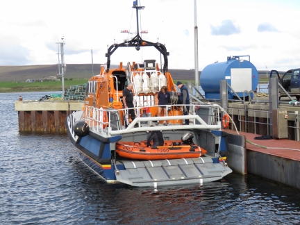
The RNLI lifeboat Helen Comrie at Longhope pier is one of three lifeboats stationed in the Orkney Islands. The other two are at Stromness and Kirkwall on the largest island, Mainland. The RNLI takes care of their crews, and increases the chance of rescue without loss of life, by using state-of-the-art equipment. The Helen Comrie is one of the more recent generations featuring the ability to launch and recover a rigid hull inflatible boat directly off the stern of the boat in even rough seas.
|
 |
On Board
Position: -3 12.35, 58 48.06
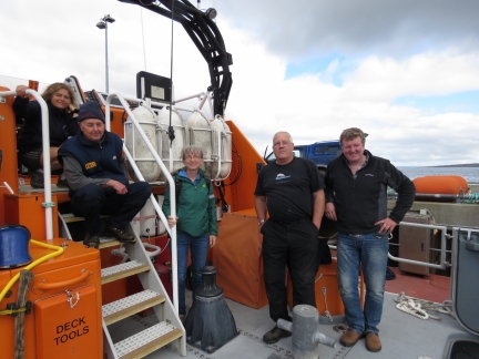
After chatting with the lifeboat crew for a few minutes, they invited us on board for a tour. From left to right are Dr. Christine Bradshaw, Jamie Wild, Colin Bates and coxswain Kevin Kirkpatrick.
|
 |
Flybridge
Position: -3 12.35, 58 48.06
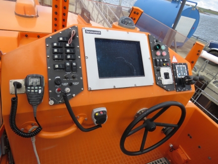
The flybridge, like all helm stations on the Helen Comrie, is well equipped
|
 |
Interior
Position: -3 12.35, 58 48.06
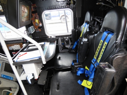
All seats inside the RNLI lifeboat are equiped with large multi-point seat belts. One of the most common causes of injury in boats operating in tough weather is falling or being hit by flying equipment or violent motion from the boat. Consequently all seating positions employ air suspended seats, large seat belts, and the boat is designed such that one operator can, without needing to shift seats, take over from another who might be incapacitated or busy doing something else. All critical equipment is accessable from multiple crew in different sitting positions without anyone needed to get up.
|
 |
Electronics
Position: -3 12.35, 58 48.06
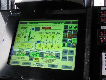
The lifeboat has custom electronics that allow the crew to monitor and control all systems in the boat from multiple stations. This page allows them to control the on board dewatering systems.
|
 |
Engine Room
Position: -3 12.35, 58 48.06
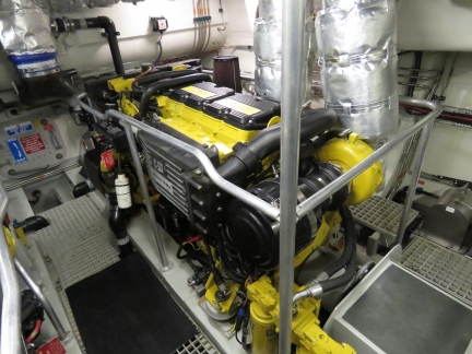
This 16 meter RNLI lifeboat went into service in 2006 and it is powered by two Caterpillar C18 engines producing 1,000 hp each driving fixed pitch 5 blade props and is able to run at 25 kts. The RNLI goal is to be able get a call and be able to be underway on average in only 10 min after they are called for. That’s with each member of the crew at work, or at home, and even possibly asleep. They need to be able to drop what they are doing and get to the boat. The first crewman arriving starts the engines and powers up the control systems and, as the full crew complement arrives, they drop the lines and head to sea in what will be, more likely than not, rough conditions.
|
 |
Lifeboat Museum
Position: -3 13.71, 58 46.77
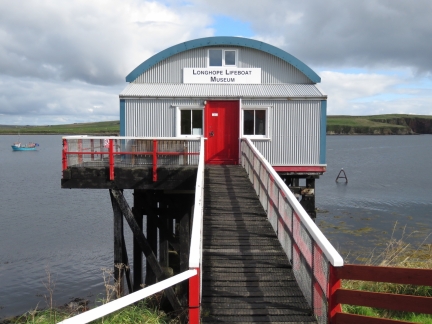
While touring the RNLI lifeboat Helen Comrie we’d asked the crew if they knew when the Longhope Lifeboat Museum would be open as we couldn’t get through by phone to check the hours. Colin Bates offered to open it up for us and, even more amazing, personally drove us there. The museum is housed in the second Longhope Lifeboat Shed, built in 1906 on Aith Hope and in use until 1999. The original shed was built in 1874 a short distance to the northwest and was unique in that it had doors at both ends so the lifeboat could be launched south into Aith Hope or, if conditions were adverse, north into North Bay to exit via Scapa Flow. The current-generation shed is located on the pier where the Helen Comrie is moored.
|
 |
Thomas McCunn
Position: -3 13.69, 58 46.77
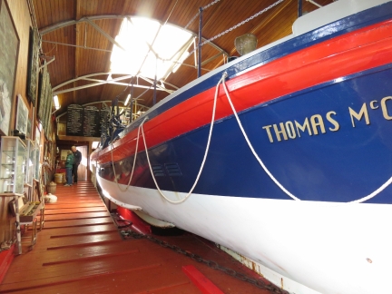
The museum is packed with information about the Longhope Lifeboat Station and its history of daring rescues. We really enjoyed the visit and Colin did a great job of explaining and showing us everything. A feature exhibit is the Longhope lifeboat Thomas McCunn, in service from 1933 to 1962. The lifeboat still is operational and is launched several times a year for non-life-saving purposes.
|
 |
Wee Fea
Position: -3 13.61, 58 49.82
After visiting the Lifeboat Museum, Colin offered to drive us up Wee Fea for the views over Scapa Flow since it was such a nice day. That was very kind of him. The view certainly was impressive. Leftmost in the photo is the old World War II Naval Headquarters and Communications Center. Scapa Flow was the base for the British Fleet during the two World Wars. The point of land roughly central in the photo with the large storage tank is the former Royal Navy Base at Lyness, now the Scapa Flow Museum. Beyond that point is Fara Island and slightly to the right and beyond is Flotta Island, a major North Sea oil terminal, with massive oil storage tanks visible.
|
 |
Naval Cemetery
Position: -3 12.60, 58 50.03
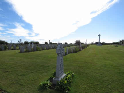
We stopped off at the Lyness Naval Cemetery on the way back to Longhope. Many of the graves are from local tragedies where ships sank in and around Scapa Flow and the Orkney Islands.
|
 |
Two-Screw View
Position: -3 12.54, 58 47.31
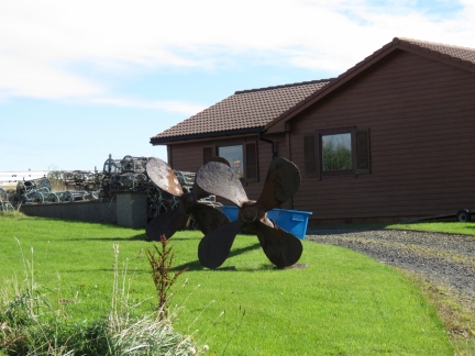
This house on a hill has two propellers out front and the owner calls it a “two-screw view”
|
 |
Hackness Battery
Position: -3 8.95, 58 48.35
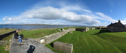
We’d brought the bikes ashore with a plan of cycling to the lifeboat museum and around the area. After Colin dropped us back off at Longhope, we biked out to the Hackness Battery and Martello Tower and had a picnic lunch overlooking Hoxa Sound before touring the site. The Hackness Battery was built in 1813 to protect the anchorage in Longhope Sound for merchant ships when Britain was at war with France and the United States.
|
 |
Martello Tower
Position: -3 8.81, 58 48.23
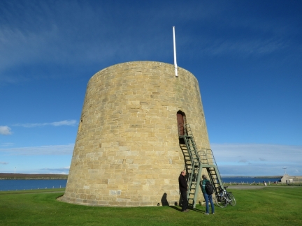
A Martello Tower was added to the Hackness Battery fortifications in 1814, with a second across the sound. Martello Towers take their name from Martelle Point in Corsica, Italy where in 1794 two small cannons mounted on top of a round tower fended off an attack by two British warships with a combined firepower of 106 guns. The British were so impressed that they built over 100 such towers around the south and east coasts of England in the early 1800s when Napoleon was building an invasion fleet. Only one other Martello tower survives in Scotland, at Leith in Edinburgh.
The tower is elliptical, with the thickest part 14ft (4.25m) thick and facing the sea. The ground floor included barrack and ordnance stores, the first floor is the barrack room and was originally entered by a wooden ladder, and the gun was mounted on the roof. |
 |
Gun Emplacement
Position: -3 8.81, 58 48.23
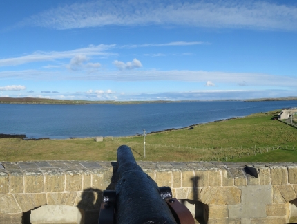
The original gun in the Martello Tower was a 24-pounder that could fire a 24lb (10.9kg) shot 1.5 miles (2.4km). It later was replace by a 68-pounder that could had a shorter range of just over a mile (1.9km) but with a more devastating effect. The present gun is a 64-pounder of the same vintage.
|
 |
Flotta Island
Position: -3 8.81, 58 48.24
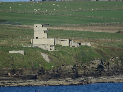
World War II fortifications on Flotta Head across Hoxa Sound from the Martello Tower.
|
 |
Lifeboat Memorial
Position: -3 9.26, 58 47.30
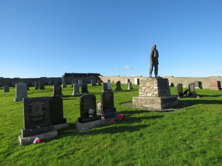
A memorial to the crew of the Longhope RNLI Lifeboat T.G.B.. On March 17th, 1969 the Longhope station suffered one of the worse losses in British lifeboat history when the T.G.B. responded to a Mayday call from the Liberian-registered cargo ship Irene that had been driven aground during a severe gale. A huge wave, estimated to be 100ft high, capsized the T.G.B., which was not self-righting. All eight crew were killed, including the coxswain and his two sons, and the 2nd coxswain and his two sons. Kevin Kirkpatrick, the current coxswain, lost his father, grandfather and uncle in that single event.
|
 |
Dirona
Position: -3 11.87, 58 47.91
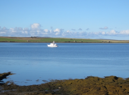
Dirona at anchor in Long Hope on our return back to the pier.
|
 |
Lifeboat Underway
Position: -3 12.29, 58 48.05
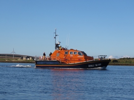
When we arrived at the harbor, the Helen Comrie was about to get underway with a television crew on board. We dropped off the bikes on Dirona and went back out to watch the lifeboat maneuver in the bay.
|
 |
Tender Tube
Position: -3 10.96, 58 48.26
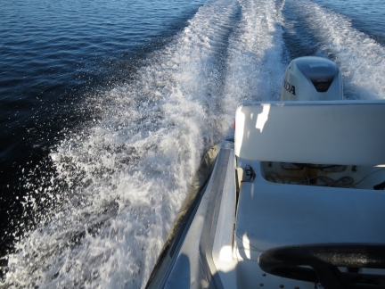
We were underway in moderate seas at high speed and the boat was fully inflated when it suddenly tilted to the right. We looked down and the entire right side tube had just gone flat and, even more unusual, it was quickly vacuuming down to the shape of the fiberglass boat in which the tube was glued. Ironically, the Longhope lifeboat Helen Comrie was underway nearby with a film crew on board. We were hoping not to need their assistance and end up become part of the documentary. Read more …
|
 |
Hoy Head
Position: -3 11.81, 58 48.16
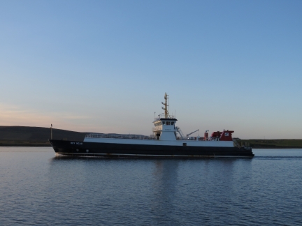
The ferry Hoy Head arriving in the early evening. The vessel overnights at Longhope and during the day runs between Lyness, Flotta Island and Houton on Mainland.
|
 |
Sunrise
Position: -3 11.84, 58 48.18
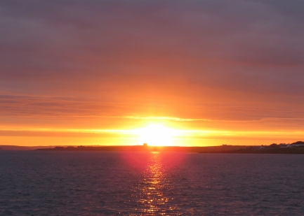
Beautiful sunrise over the Martello Tower.
|
 |
Click the travel log icon on the left to see these locations on a map, with the complete log of our cruise.
On the map page, clicking on a camera or text icon will display a picture and/or log entry for that location, and clicking on the smaller icons along the route will display latitude, longitude and other navigation data for that location. And a live map of our current route and most recent log entries always is available at http://mvdirona.com/maps. |

While in Campbeltown, Scotland, we spent way too much time in the little RNLI shop buying stuff. :) They had some really good quality clothes, and surprisingly, RNLI ear buds with a nice orange cloth protecting the wire. The volunteer running the store was a man who just moved to the area and figured he needed to do his part to help the community.
We got a tour the boat from one of the shore bound crew. He used to go out but had an injury preventing rescue work on the boat but he continued to help with other duties. Very nice guy. He showed us around the boat which was very impressive. The amount of money they need to raise just for fuel is amazing. Seems like it was 200 L/H for each engine.
As your photos show, the boat is very well equipped and laid out. Almost like a spaceship. The quarters down below for those who have been rescued was well thought out as well. They also have a RIB on a trailer pulled by a Landrover that is used for beach rescues on the other side of Peninsula.
The boat went out that night, and since we were docked right across from them, we could easily hear the engines startup and then felt the wake as they left.
They went out and rescued two guys in what we would call a ski boat that was about 16-20 feet long and looked like it was 40-50 years old. The guys decided to go to Northern Island for a drink and ran out of gas crossing the North Channel getting back home.
We saw the wee little boat they towed home, one of it’s cleats failed during the tow, and the RNLI guy we had met the day before said he would not have taken that boat out of the Campbeltown loch much less go to Northern Ireland. He was right of course.
The RNLI likely saved the lives of those two guys but the fuel burned by the Cambeltown boat was likely worth more than the ski boat they towed home.
My understanding is that the RNLI is totally dependent on their fund raising operations and receives no tax payer support. How they manage to fund the many boats along the coast is impressive.
Thanks for your recount of your RNLI visit. They really are an impressive organization.
Interesting story about the RNLI, thanks!
Most probably you will get to the island of Helgoland sometime in the future. If so you will have a chance to see the HERMANN MERWEDE, the biggest rescue boat (a ship, actually) of the german sea rescue organization, the DGzRS or „Seenotretter“.
It‘s funded by donations only, too, and they have a lot of interesting vessels.
And BTW if you are on Helgoland, make sure to get fueled: You can get Diesel tax free and it‘s the only Diesel supply around where you can get pure Diesel without bio.
Thanks for the tip on the Hermann Merwede and low cost fueling. Next year we plan to leave London around March 15 and head over the continent. We’ll work our way north with at least a stop over to explore in Amsterdam (since we are picking up our new tender there). Then we’ll work north to spend the summer in Norway so we will be in the area of Helgoland.
Thanks Julian for the recommendation to go to Helgoland for Duty free fuel. We stopped off on our trip from the Netherlands to Norway. We did a quick fuel-and-go so didn’t look around but will be able to do that on our trip south.