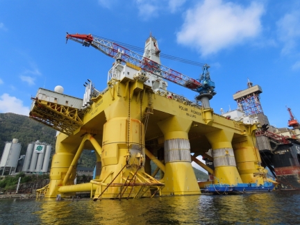
While we were rounding the world in Dirona, so too was the oil rig Polar Pioneer, including a stop at our home port of Seattle. The rig circumnavigated in 2014-2016, starting in Norway, then to Singapore and on to Alaska for an assignment, then to Seattle and back to Norway via South America. While in Seattle, it was targeted by environmental protesters known as ‘kayaktivists‘, who tried to stop it docking because it was being used to explore for oil offshore Alaska.
We spent one more night in the beautiful anchorage at Toftekalven, then made a quick 11-mile run to Vagen off Etnefjorden. From there we made a tender tour through adjacent Olsfjorden to the Westcon shipyard at the head, the starting and ending point of the Polar Pioneer‘s circumnavigation. Also at Westcon were the semi-submersible oil rig Scarabeo 8, one of the most advanced oil rigs in the world when completed in 2012, and the jackup rig West Epsilon.
Below are highlights from August 13th and 14th, 2020. Click any image for a larger view, or click the position to view the location on a map. And a live map of our current route and most recent log entries always is available at mvdirona.com/maps.
 |
Staple Bolts
Position: 59°45.22’N, 5°50.27’E
Two of the bolts holding our swimstep staples in place had fallen out, so we replaced then with spares. That’s the last of our spares, so we’ll need to source some new ones.
|
 |
Drilling Drive
Position: 59°45.22’N, 5°50.27’E
Drilling through the disk drive from an old laptop for safe discarding without risk of anyone being able to resurrect the data.
|
 |
Oil Change
Position: 59°45.23’N, 5°50.27’E
Performing our 31st oil change on the generator at 6,903 hours. It’s been running beautifully since replacing the cylinder head.
|
 |
Breakfast
Position: 59°38.74’N, 5°54.13’E
Breakfast outside on an ultra calm morning shortly after arriving at the anchorage in Vagen off Etnefjorden.
|
 |
Spitfire
Position: 59°38.75’N, 5°54.14’E
Spitfire taking in the view of the anchorage at Vagen.
|
 |
Lumber
Position: 59°36.99’N, 5°47.32’E
Passing a dock-full of lumber ready for shipping at Basnes in Olsfjorden while out on a tender tour of the area.
|
 |
West Epsilon
Position: 59°36.31’N, 5°46.50’E
The jackup rig West Epsilon moored off the Westcon shipyard near the head of Olsfjorden. The 256.5 x 296 x 35-foot rig stands of legs 541 feet high and has a maximum water depth of 400ft and a maximum drilling depth of 30,000ft. It has been operating in the North Sea since 1992 and is currently in storage at Westcon.
|
 |
Ronja Strand
Position: 59°36.31’N, 5°46.23’E
The 278ft (85 m) fish carrier Ronja Strand, one of many Ronja ships we’ve seen in Norway and Scotland, in the drydock at Westcon shipyard.
|
 |
Articulating Rudder
Position: 59°36.32’N, 5°46.21’E
Close-up of the articulating rudder, ducted propeller and stern thruster on the Ronja Strand.
|
 |
Artemis Odyssey
Position: 59°36.41’N, 5°46.24’E
The survey ship Artemis Odyssey at the Westcon shipyard in Olsfjorden.
|
 |
Bruce Anchor
Position: 59°36.32’N, 5°46.13’E
A very large Bruce anchor, a popular choice for anchoring oil rigs, ashore at the Westcon shipyard.
|
 |
Scarabeo 8
Position: 59°36.25’N, 5°46.03’E
The oil rig Scarabeo 8 at the Westcon yard for maintenance where it was originally built. The semi-submersible rig was one of the most advanced oil rigs when completed in 2012, with a drilling depth of 9,850ft (3,000m).
|
 |
Polar Pioneer
Position: 59°36.22’N, 5°45.82’E
The oil rig Polar Pioneer at the Westcon yard. The rig circumnavigated in 2014-2016, starting at Westcon, then to Singapore and on to Alaska for an assignment, then to Seattle and back to Westcon via South America. While in Seattle, it was targeted by environmental protesters known as ‘kayaktivists‘, who tried to stop it docking because it was being used to explore for oil offshore Alaska. The rig has not had an assignment since 2017 when Shell canceled a contract and currently is scheduled to go into scrap, but a company is considering purchasing it to use as an offshore fish-farm.
|
 |
Click the travel log icon on the left to see these locations on a map, with the complete log of our cruise.
On the map page, clicking on a camera or text icon will display a picture and/or log entry for that location, and clicking on the smaller icons along the route will display latitude, longitude and other navigation data for that location. And a live map of our current route and most recent log entries always is available at mvdirona.com/maps. |

Looking at your trails on the charts with blog posts make it clear how the incredibly convoluted Norwegian coastline offers endless places to explore and moor. It looks like you have poked into almost every nook and cranny possible. Wonderful scenery and interesting ships and industrial facilities.
Yes, exactly John. On our first trip to Norway, we wanted to really cover the west coast and get to the most notable spots so we kept moving a covered a lot of ground. This time, we’re focused on the details and just slowly working our way north. We’re not sure which approach is best — we have loved both trips — but we’re really enjoying getting into the details without a set schedule. Norway is incredible.