|
A Brief Foray into the
Dangerous Waters of Nitinat
By
Jennifer and James Hamilton
We've never outgrown that youthful reaction to being told
not to do something because it's dangerous.
Invariably, we must try.
This is partly how we came to be west of the
treacherous Nitinat
Narrows on Vancouver Island's
southwest coast, gauging the risk of entry.
The
Nitinat
Narrows
are situated midway along the shoreline known as the "Graveyard of the Pacific".
But their locale does not overshadow them.
"More boats have been capsized in the attempt,"
notes George Nicholson in Vancouver
Island's West Coast, "some with considerable loss of life, than at any other
passage of its kind on the British Columbia
Coast."
The waterway bisects the West Coast Trial and
connects Nitinat
Lake, world-famous for windsurfing, to the
Pacific Ocean.
This natural tidal estuary is locally known as "The
Gap." It
is barely 30 meters wide at points, and the current can reach eight knots.
These are not the only hazards.
The waterway empties into the Pacific Ocean over Nitinat Bar, a shallow sandbar with a
least charted depth of 1 to 2 meters.
At the bar, incoming ocean seas clash with an
outgoing tide from the narrows and multiply the danger of transit.
And a 1-meter reef lies only 75 meters from the bar
entrance channel. The
reef is visible in calm conditions, but would disappear under breaking surf.
It is known locally as Sawtooth Rock, and its teeth
have likely sunk into many a hull.
These waters lie within the territory of the Ditidaht First
Nation, from whose language Nitinat is derived, meaning "dangerous rushing
water".
"A crossing of this bar and negotiation of the narrows to
Nitinat Lake," writes Robert Hale in
the 2004 Waggoner Cruising Guide, "is
considered a supreme Northwest navigation challenge by a small number of
adventurers." How
could we resist?
A Dangerous
Passage
We're willing to take risks, but we do try to go in
prepared.
We knew that there must be a safe way to enter, because a
cannery once operated inside.
Ships
of substantial size must have passed through to transport people, provisions,
and the canned salmon.
Under the right circumstances, we reasoned, we could
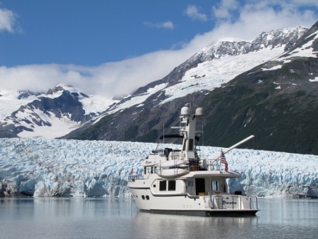
safely do the same in our 40-foot power boat
Dirona.
In researching how to enter, we found plenty of references
to
Nitinat
Narrows.
However, most described fatal or frightening
crossings.
According to
Shipwrecks off Juan de Fuca, the 52-foot pleasure cruiser
Inlet Queen struck the bar in 1912,
filled with water, and sank.
Fortunately,
all aboard made it to shore.
In
"Breakers Ahead!" Bruce Scott
describes the wreck, six years later, of the cannery tender
Renfrew.
A
breaker splashed through an open skylight and stalled the engine—the ship
immediately turned broadside to the waves and sank.
The
surf tore the pilot house from the vessel, which washed ashore with the captain
clinging to it. Of
the twenty-six on board that day, only half survived.
Keith Keller's
Dangerous Waters tells a modern-day tale of disaster. In 1994, a small
sports-fishing boat was sucked into the narrows from lakeside and demolished by
breakers exceeding 25 feet.
Those aboard were nearly killed.
They were rescued by two local fisherman who pursued
them through The Gap and were awarded medals of bravery from the Royal
Lifesaving Society of Canada.
The Douglass's
Exploring the West Coast of Vancouver Island contains a less harrowing, but
no more encouraging, account.
"While it was exciting, it was not enjoyable" is how
the authors summarized their entry on a fast flood.
They could see the bottom while crossing the bar,
and estimated the minimum depth to be 3 feet, not the charted 2 meters.
Once in the narrows, they could barely maintain
course in the swift, swirling current.
With no room to turn, they spun their vessel around
in a large whirlpool and retreated.
In
Day by Day to Alaska, Dale Petersen
relates his less-traumatic transit on an estimated 3-knot ebb current, but he
touched bottom en route.
Crossing the
Bar
When was it safe to enter?
We couldn't find the answer to this question
anywhere. Based
on some assumptions confirmed by local knowledge (see sidebar), we concluded
that entry should be attempted only at high-water slack, with calm seas.
As we
approached the narrows on our planned day of transit, conditions seemed perfect.
The swell was less than 1 meter and it was an hour
before the turn to ebb.
This gave us plenty of time to take stock.
Our
first problem was that we couldn't see the opening.
There
was only the relentless Pacific pounding against barren bluffs.
Despite
the calm conditions, surf exploded well up the sides.
A few sports-fishing boats clustered near shore were our
first clue—they must have come through The Gap.
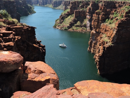
As we neared, an opening in the cliff came into
view.
Even though we'd seen pictures, we were surprised at how
narrow and steep-to it was.
The slim gash in the cliff looked almost
supernatural, as if it led to some evil sorcerer's lair.
The bar itself was evident by the swells, which
steepened at the shallow water.
The waves were small though, and none were
breaking. We
cautiously nosed towards them and monitored the depth while studying the narrows
through binoculars. The
current did not seem active, so we decided to proceed.
The channel through the bar is less than ten meters wide
and bounded by two-meter contour lines.
On either side, the charted depths are 0.9 and 1.5
meters. The
channel is unmarked and difficult to locate—the only reference point is Sawtooth
Rock.
As we neared, the depth fell from over 50 meters to less
than 10.
We crept ahead, trying to find the entrance channel through
GPS and depth readings.
Sawtooth Rock appeared to port.
It was conspicuous in these calm conditions, but it
still looked ominous. The
depth fell below eight meters and Dirona's
undulating motion became more pronounced in the steeper swells.
At
roughly where the entrance channel should be, the depth dropped to 2.5 meters.
We did not expect to see less than 5 meters, as we
had nearly 3 meters of tide height.
The chart might be inaccurate, but we were probably
slightly off course. The
entrance channel is short, and we were soon into deeper water on the other side.
Through the Narrows
The depth increased beyond 10 meters as we entered the
narrows.
High water slack was a half hour away and the current was
still flooding at perhaps 1-2 knots.
But there were no whirlpools or overfalls.
We had no difficulty staying centered up in the
channel and had plenty of depth, so were able to take in the surroundings.
To our right were the remains of Whyac, which was
once a major village of the Ditidaht.
A small campsite was setup there, with a view to
the open Pacific.
Just inside, the inhospitable terrain gave way to a lush,
green forest.
It was as if the forbidding entrance was merely a facade to
discourage unwelcome visitors.
Our plan was to drop the hook in Cannery
Bay, explore
further by dinghy, and depart at high water slack the following day.
Near the entrance to this bay, a float on the
western shore marked the West Coast Trail—hikers must purchase a ferry ride
across the narrows.
The waterway widens here and continues into Nitinat
Lake, but the navigable channel is constricted by several
charted rocks at the southern end of
Cannery
Bay.
To avoid them, you must hug the southeast shore as
you enter the bay.
As we turned to starboard, the flooding current pushed us
broadside towards the rocks, which were visible just under the surface.
A little horsepower helped us through, but a vessel
with minimal power should transit closer to slack.
Cannery
Bay
Cannery
Bay
was serene; a multi-hued forest crowded the shore.
To
the north were the remains of an old cable car, presumably once used to cross
the narrows. The
cannery ruins, a few pilings and some stonework, were visible to the east.
A dozen or so hikers had gathered to await the ferry
on the southeast shore.
The ferry crew were elated at our appearance and
called out many questions.
Carl Edgar, our source of local knowledge and a
member of the Ditidaht First Nation, has long operated both the West Coast Trail
ferry at Nitinat and the adjacent Nitinaht Bar and Grill.
Dungeness crab is abundant here, the feature item on
the menu.
We hoped to visit with Carl and purchase one of their
t-shirts, which showed the restaurant name and its fare.
Anchoring would turn out to be a greater challenge than
transiting the narrows. We
dropped the hook just west of the old cannery, but the anchor would not set.
After several attempts with successively more scope,
we raised the anchor and discovered our problem: a huge rock was wedged in the
flukes.
It filled the cradle of our 40kg Bruce and must have
weighed at least 50kg.
The rock was firmly wedged—the flukes were even
sprung open slightly. It
would take time and leverage to remove it, so we had to either anchor with our
spare or find room to drift.
We tried to cross to the west side of the bay in
order to proceed north into
Nitinat
Lake.
However, we couldn't locate the charted 2.4-meter
channel across.
To get to the lake, we would need to return to the southern
end of Cannery
Bay and manoeuvre around
the rocks at the entrance.
We considered setting the spare anchor while
releasing the rock.
However, with our main disabled, we were feeling less
adventuresome and the appeal of this anchorage was wearing thin.
Fortunately, the current was not yet ebbing.
So we hauled the tackle up, rock and all, and made
our exit.
The return was even less stressful than the entry, barring
the fact that we had the rock to deal with.
We were soon back out and into the Pacific, where we
loosened the rock with hammer and chisel, dumped it, and proceeded to Bamfield
for the night.
While we hadn't accomplished all that we'd planned, we had
conquered the dangerous waters of Nitinat.
Sidebar: If
you go
You don't just arrive at
Nitinat
Narrows and decide to go
through—you must plan in advance for ideal conditions.
We found no advice on how to enter, so we made an
educated guess.
Pacific Ocean river bars are safest to cross near the end
of a flooding current, as depths are maximal and the tidal action is in the same
direction as the ocean swell.
When
they are in opposition, steep and dangerous seas can result.
Calm seas are preferable, as heavy ocean swell alone
can produce breakers over a shallow bar.
Further, any tidal passage is safest at slack water.
Given
the minimal depths, we concluded that high-water slack, with calm seas, were the
ideal conditions for crossing the bar and transiting the narrows.
Seeking
confirmation and local knowledge, we eventually spoke with Carl Edgar of the
Ditidaht First Nation. Carl
lives in the region and has passed through the narrows many times.
Edgar's advice, that we could enter any time on the
flood, but not on the ebb, supported our plan.
He also confirmed that the chart and slack water
calculations were accurate.
High-water slack at Nitinat Bar is 2 hours and fifteen
minutes after high water at Tofino.
To cross the bar, aim for the deepest part of
channel, just outside the 2-meter line, and keep the charted rocks off Tsuquanah
Point to port.
The narrow themselves are well-charted and easily transited
at high-water slack.
As you approach Cannery
Bay, keep clear of the rocks at the entrance by either
turning sharply to starboard or hugging the western shore of the channel to
Nitinat Lake.
Cannery
Bay
itself is extremely shallow at both ends.
According to CHS, readings taken at the cannery give
the tidal range as 0.3 to 0.5 meters, so actual and charted depths will be
similar.
This article
originally appeared in
Pacific Yachting,
August 2004.
|