MV Dirona travel digest for St. Lucia 2016

|
Click the travel log icon on the left to see these locations on a map,
with the complete log of our cruise. On the map page, clicking on a camera or text icon will display a picture and/or log entry for that location, and clicking on the smaller icons along the route will display latitude, longitude and other navigation data for that location. And a live map of our current route and most recent log entries always is available at //mvdirona.com/maps/LocationCurrent.html. |
 |
2/21/2016: Fuel economy
Position: 14°6.41'N, -60°53.38'W
The 97 nautical mile crossing to St. Lucia was in fairly calm water and we were running WAY slower than usual for us. We just putted along at 5 kts to arrive at 8am. Jennifer was able to do her regular shift and most things she normally does underway and we had a great passage. We normally don't focus much on fuel economy and rarely run that slow, but we only burned 33 gallons which is a silly 2.9 nm/gal. This is unusually high for a 110,000 lb vessel. We must have had significant current help as well. The screenshot shows our "drive the lights" indicator at the bottom center of the screen lit in red to indicate we should slow down. At 920 RPM we should be doing 4.2 knots in flat water, but we're doing 5.1 knots at sea, and getting 4.18 nm/gallon.
|
 |
2/21/2016: Approaching St. Lucia
Position: 14°7.20'N, -60°55.24'W
It seemed we'd hardly left Barbados before the lights of St. Lucia were visible in the distance. This was by far our shortest trip since in the past half-year. All of our trips during that period have been have been several days to multiple weeks.
|
 |
2/21/2016: Lines
Position: 14°5.08'N, -60°57.91'W
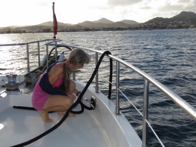
We had some assistance with the lines on both ends of the trip, which we don't normally need or even particularly want. But with the recovering collar bone it made a big difference and the trip was actually pretty easy. It's a bit of work to get the fenders and lines setup, but the doctors said activity is fine, in fact it's good, so long as it doesn't hurt.
|
 |
2/21/2016: Rodney Bay
Position: 14°4.73'N, -60°57.49'W
The view across the anchorage at Rodney Bay as we head towards the marina entrance channel.
|
 |
2/21/2016: Skiffs
Position: 14°4.72'N, -60°57.24'W
The colorful local skiffs lined up along the marina entrance channel reminded us of ones we'd seen in Fiji.
|
 |
2/21/2016: Moored
Position: 14°4.44'N, -60°57.02'W
In our slip at the Rodney Bay marina. The marina staff was super-helpful and it made arriving with an injury easy.
|
 |
2/21/2016: SailClear
Position: 14°4.55'N, -60°56.91'W
St. Lucia and several other Caribbean countries participate in an online clearance system, SailClear.com, where boaters can register their boat and crew information online and then submit an arrival or departure notification for a given destination. This was our first time using SailClear and it was super-convenient. Shortly after we'd arrived at Customs, they had printed off and stamped several copies of our paperwork. We then had three more quick checkins with Immigration, the Port Captain and the Port Health Officer and were done.
|
 |
2/21/2016: Police
Position: 14°4.44'N, -60°57.02'W
Parts of St. Lucia to the south have had several incidences of theft and voilence aginst boaters, but where we are at Rodney Bay Marina seems very safe and secure. And it was good to see a police boat patrolling the area.
|
 |
2/21/2016: Goats
Position: 14°4.85'N, -60°57.04'W
We took a walk around the area and came across these two cute goats in the village of Gros Islet just north of the marina.
|
 |
2/21/2016: Gros Islet
Position: 14°4.86'N, -60°57.16'W
The parish of Gros Islet dates back to 1749, when one of the first priests to arrive at St. Lucia settled here. The Sunday service had just ended and the street outside was busy with churchgoers. The horse being led by out front seemed to fit the scene perfectly.
|
 |
2/21/2016: St Joseph
Position: 14°4.88'N, -60°57.16'W
Several Catholic churches have served the parish of Gros Islet on this site. The current St. Joseph Roman Catholic Church replaced one that was only 30 years old when it was destroyed in a 1906 earthquake. The high vaulted ceiling is made of thin wood strips and looks somewhat like the bottom of a ship, and the Caribbean-style decor gives the church a bright and airy feel.
|
 |
2/21/2016: Independence Day
Position: 14°4.90'N, -60°57.16'W
St. Lucia changed hands 14 times, mainly between Britain and France, and Britain maintained control from 1814 until February 22nd, 1979. The country still has a strong French heritage though--our immigration clearance documents were in French and English. Tomorrow St Lucia celebrates the 37th anniversary of their independence from Britain. The streets were full of St. Lucia flags and its colors, cars were decorated, and many people sported the turquoise and yellow flag colors as well.
|
 |
2/21/2016: Bay St.
Position: 14°4.89'N, -60°57.25'W
Looking northwest across Rodney Bay from Bay St., with Pigeon Island in the distance.
|
 |
2/21/2016: Street party
Position: 14°4.82'N, -60°57.22'W
Every Friday night Gros Islet hosts a music-filled street party with traditional Creole fare and plenty of alcohol. That might explain the surprising number of bars and small restaurants that lined the village streets. We saw several sets of speakers being set out, perhaps for Independence Day festivities tomorrow.
|
 |
2/21/2016: Elena's
Position: 14°4.53'N, -60°56.93'W
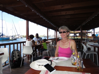
We had an excellent pizza with the local brew Piton for lunch dockside at Elena's in the Rodney Bay Marina.
|
 |
2/21/2016: 2015 ARC
Position: 14°4.47'N, -60°57.02'W
One of the 2015 ARC (Atlantic Rally for Cruisers) participants, One & Only. The rally leaves Grand Canary Island in November and arrives into Rodney Bay in December and attracts over 1,200 sailors in more than 200 boats. The marina here is large, but must have been crazy-busy when that fleet arrived. The World ARC rally that we've encountered a few times also finishes in Rodney Bay in April.
|
 |
2/21/2016: Nordhavns
Position: 14°4.44'N, -60°57.03'W
After parting a couple of weeks back, the 2016 Nordhavn Barbados Rendezvous participants co-incidentally all arrived into Rodney Bay the same day and we got together for drinks on Dirona that night. Jo and Robbie Ashton of Nordhavn 47 Southern Star are on the right, with Mark and Jennifer Ullman of Nordhavn 46 Starlet in the center. Two more Nordhavns actually are currently at Rodney Bay: a 55 and a 46, and another 47, Moonrise, just left. Doug Harlow recently posted his video interview of the group, Three Nordhavns in Barbados.
|
 |
2/22/2016: Annual pump maintenance
Position: 14°4.44'N, -60°57.02'W
James did the annual maintenance for the emergency water pump today. Every year he drains out the old gas, replaces it with new stabilized fuel, tests ease of start and operation, changes the oil, and adds non-toxic antifreeze to keep the pump primed.
|
 |
2/22/2016: Thai One On
Position: 14°4.53'N, -60°56.92'W
Thai One On has great food, and even better, a second floor view over the whole marina.
|
 |
2/23/2016: Limin'
Position: 14°4.44'N, -60°57.02'W
Guess who is best on the boat at limin'?
|
 |
2/23/2016: Digicel
Position: 14°4.66'N, -60°56.86'W
Back at Digicel, this time Digicel St. Lucia, to get a SIM card. They were closed Sunday, and Monday for Independence Day, so we couldn't get a SIM until Tuesday.
|
 |
2/23/2016: The Mall
Position: 14°4.15'N, -60°57.23'W
After picking up our SIM card, we walked over to the Rodney Bay Mall to check out the stores there. There is a dinghy dock there we could run the tender to, but we wanted to walk at least once to see what was on the road on the way there. There was a fair-sized grocery store, but not many other retail outlets on the way down.
|
 |
2/23/2016: Antilla Brewing Company
Position: 14°4.25'N, -60°57.24'W
The Antilla Brewing Company has a brewpub near the mall. We were there before 11am and they don't open for lunch until 1pm, but we'll definitely be back.
|
 |
2/23/2016: Spinnakers
Position: 14°4.58'N, -60°57.28'W
After exploring the mall area some more we walked down Reduit Beach Ave and had a great meal beachside at Spinnakers.
|
 |
2/23/2016: Guest
Position: 14°4.58'N, -60°57.28'W
A lunch guest shared the third seat at our table.
|
 |
2/23/2016: Reduit Beach
Position: 14°4.58'N, -60°57.28'W
Reduit Beach was full of sunbathers with more arriving by the minute. They really pack them in.
|
 |
2/23/2016: Pizza
Position: 14°4.53'N, -60°56.93'W
We got together with Jo and Robbie Ashton of Nordhavn 47 Southern Star and Mark and Jennifer Ullman of Nordhavn 46 Starlet for a pizza dinner dockside at Elana's
|
 |
2/24/2016: Propane
Position: 14°4.44'N, -60°57.02'W
We carry four propane cylinders and have only filled them once, in New Zealand, since leaving Hawaii in early 2013. We could easily make it back to the US with what we've got, but filling them here is hard to beat for convenience: the marina staff picked them up at our boat, filled them and returned them later that day. We're now back to 4 full 20-lb containers on Dirona and can last years, even at our fairly high consumption rate.
|
 |
2/24/2016: Thai One On
Position: 14°4.53'N, -60°56.92'W
Enjoying another meal with that awesome view at Thai One On.
|
 |
2/28/2016: Thai One On
Position: 14°4.53'N, -60°56.92'W
We've spent the past few days upgrading some of our custom software and working on web site content. Tonight we returned to Thai One On for another great meal and view.
|
 |
2/29/2016: Deck fuel
Position: 14°4.44'N, -60°57.02'W
We carry two 29-gallon wheeled gasoline tanks on the boat deck. When using the tender a lot, we have them both filled. But gasoline doesn't last well, so when we're planning to use the tender less, we only full up one tank and sometimes not even all of that one. We last filled one in Darwin, and have about 20 gallons right now. Since we're likely to be using the tender more, so we decided to fill one in here at Rodney Bay. When designing the boat, we initially were planning to have a fixed gasoline storage area built-in along with one for new and waste oil. We're really glad we couldn't find a solution to locating those, as having portable containers is much more convenient. Being able to get oil, gasoline and diesel all in the same place has been rare on this trip and we're often having to transport oil and gas a fair distance from where the boat is moored. Sometimes the only option is to wheel the tank ashore somewhere. Here we can just drop the tank into the tender and run it over to the local marine fuel station.
|
 |
2/29/2016: Refueling
Position: 14°4.70'N, -60°56.93'W
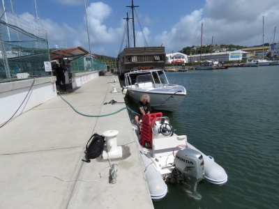
James filling the 29-gallon deck fuel tank.
|
 |
2/29/2016: Spinnakers
Position: 14°4.58'N, -60°57.28'W
When we'd first visited Spinnakers, we'd walked the few blocks there from the mall at Rodney Bay. A tender dock is near the mall, but on our way over to the fuel dock, we noticed an empty lot with a serviceable dock that was directly across the peninsula from Spinnakers. So after dropping off the gas tank, we locked the tender at the lot and were at Spinnakers in less than five minutes.
|
 |
2/29/2016: Jose Marti
Position: 14°4.49'N, -60°57.22'W
While walking back to the tender from Spinnakers, we noticed this memorial to Cuban national hero Jose Marti.
|
 |
2/29/2016: Tender mooring
Position: 14°4.44'N, -60°57.03'W
Boats passing through the channel behind us sometimes throw fair-sized wakes, so we tucked the tender under the bow to keep it from bashing against the swim step. We'd have the tender locked either way, but this spot also feels a little more secure from a theft perspective.
|
 |
2/29/2016: Sunset
Position: 14°4.54'N, -60°56.94'W
We had sunset drinks at the Boardwalk bar in the marina complex.
|
 |
3/2/2016: Morning
Position: 14°4.44'N, -60°57.02'W
Spitfire surveying the early-morning scene.
|
 |
3/2/2016: Dinghy trip
Position: 14°4.44'N, -60°57.02'W
We dropped the tender today to tour the area.
|
 |
3/2/2016: Dinghy dock
Position: 14°4.20'N, -60°57.14'W
The dinghy dock at the Rodney Bay mall. The balcony on the right is a restaurant, Tapas, overlooking the bay. We've not tied the dinghy off there yet, but there's always been a local sitting there when we've gone past. Probably they will offer to "watch" the dinghy for a fee.
|
 |
3/2/2016: Pirates of the Caribbea
Position: 14°4.65'N, -60°56.99'W
Portions of the Pirates of the Caribbean movie series was filmed in St. Lucia. One of the ships used in those movies was moored at Rodney Bay, but sank recently when it was sailing in for repairs.
|
 |
3/2/2016: Spinnakers
Position: 14°4.70'N, -60°57.31'W
The other side of the busy beach in front of Spinnakers.
|
 |
3/2/2016: Houses
Position: 14°4.14'N, -60°58.41'W
These houses on the cliff will have awesome sunset views.
|
 |
3/2/2016: Pigeon Island
Position: 14°5.49'N, -60°57.82'W
We were considering stopping off at the Pigeon Island National Historic site, but the dock there had a large "Private Jetty" sign.
|
 |
3/2/2016: Flyboard
Position: 14°5.48'N, -60°57.73'W
A flyboard is a board attached via hose to a jetpack on a personal water craft. The PWC drives the board's water jet, lifting the rider 15m in the air or propelling them headlong through the water. The jetski is nearby out of the picture, and the connection isn't that visible, so the flyboard looks like a lot like a personal jet-pack. We first saw one in Melbourne.
|
 |
3/2/2016: Sandals
Position: 14°5.45'N, -60°57.64'W
Sandals has a huge resort along Rodney Bay. It looked well-maintained, and seemed packed.
|
 |
3/2/2016: Mansion
Position: 14°4.65'N, -60°57.08'W
This mansion is along the Rodney Bay lagoon opposite the marina. It has one of those cool pool where the water runs over the edge, making there appear to be no edge.
|
 |
3/2/2016: Depthsounder
Position: 14°4.44'N, -60°57.02'W
Our dinghy depthsounder display failed with a "no transducer" error today. We really missed having it, so James took it apart and found that the connection between the transducer socket and the circuit board had corroded away.
|
 |
3/2/2016: Depthsounder repair
Position: 14°4.44'N, -60°57.02'W
James attached new wires directly to the depthsounder circuit board to work around the corroded one. This is partway through the repair where he is using alligator clips to attach the wires in order to match them up to the transducer cable. He didn't know which wires matched where, and with four wires had twenty-four possible combinations. But he managed to match them up and get the display working again. He then permanently connected the new display wires to the transducer cable and we have a working depthsounder again that should last long enough for us to be able to get a new one.
|
 |
3/2/2016: Jacques
Position: 14°4.45'N, -60°57.03'W
We ran the tender over to the dock at Jacques waterfront restaurant and had an exceptional meal there. The chef was really impressive and the service was excellent, marred only by having to ask for the bill three times over thirty minutes. And while paying the bill, they found they had brought the wrong one and more confusion ensued. Really good food, good service, but missed on some details.
|
 |
3/3/2016: Beach
Position: 14°5.55'N, -60°57.72'W
We took a taxi from the marina over to explore Pigeon Island National Landmark. The island once was detached from the mainland until a causeway was built in 1973. A popular beach is adjacent to the site, with plenty of people out enjoying the sunny day. The cruise ship in the background is the Star Legend.
|
 |
3/3/2016: Officer's kitchen
Position: 14°5.59'N, -60°57.70'W
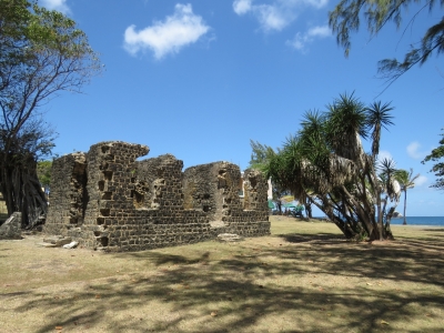
Staring in the late 1700s the British navy occupied and fortified Pigeon Island. Many of the ruins from that time still stand and are being restored. This is the officer's kitchen.
|
 |
3/3/2016: Soldier's barracks
Position: 14°5.61'N, -60°57.78'W
The ruins of the soldier's barracks on Pigeon Island.
|
 |
3/3/2016: Jambe de Bois
Position: 14°5.51'N, -60°57.88'W
We had a good meal on the patio at the Jambe de Bois restaurant. In the 1500s, Pigeon Island was a pirate's hideaway. The restaurant is named after the famous pirate Francois Leclerc, known as Le Capitaine Jambe de Bois because of his wooden leg, who was said to have hid out here.
|
 |
3/3/2016: Fort Rodnay
Position: 14°5.46'N, -60°57.99'W
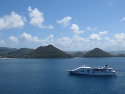
The main reason we came to Pigeon Island was for the fabulous views. This is looking south across Rodney Bay from Fort Rodney. The 443ft Star Legend below is about half the size of the Alaska cruise ships we used to see at Bell Harbor in Seattle, such as the 964ft Celebrity Infinity. And it carries only 212 guests with a crew of 153, compared to 2,170 passengers and 999 crew on the Celebrity Infinity. Under a previous name, Seabourn Legend, the Star Legend appeared in the movie Speed 2 .
|
 |
3/3/2016: Rodney Bay
Position: 14°5.47'N, -60°58.00'W
The view southeast from Fort Rodney across Rodney Bay to the causeway that connects Pigeon Island with the mainland.
|
 |
3/3/2016: Cannon
Position: 14°5.47'N, -60°58.01'W
A few old cannons still are in place around the island.
|
 |
3/3/2016: Signal Peak
Position: 14°5.64'N, -60°57.89'W
The sweeping view from Signal Peak, the highest point on the island. We passed an interpretive sign on the way up that explained how cannons were transported here. A ship moored in the small bay on the northwest end of the island and the cannons were winched up through a canyon from the top of the ship's mast. Quite the engineering feat.
|
 |
3/3/2016: Captain's Cellar
Position: 14°5.63'N, -60°57.72'W
We finished the day with a beer at the Captain's Cellar. The Captain's Cellar is below the reconstructed Officer's Mess and has been furnished to resemble an early 19th century English Taven.
|
 |
3/4/2016: BBQ overhaul
Position: 14°4.44'N, -60°57.02'W
We last overhauled the barbecue three years ago at Palmyra Atoll. Over time the flame gets more and more uneven, so it' past due for a service. James cleaned it up and replace the burner and the radiant plate.
|
 |
3/5/2016: Rain
Position: 14°4.44'N, -60°57.02'W
We got a torrential downpour this morning. And this isn't even the wet season-wonder what it's like then?
|