MV Dirona travel digest for Richards Bay, South Africa 2015

|
Click the travel log icon on the left to see these locations on a map,
with the complete log of our cruise. On the map page, clicking on a camera or text icon will display a picture and/or log entry for that location, and clicking on the smaller icons along the route will display latitude, longitude and other navigation data for that location. And a live map of our current route and most recent log entries always is available at //mvdirona.com/maps/LocationCurrent.html. |
 |
10/26/2015: Customs
Position: -28°47.66'S, 32°4.70'E
Customs came by this morning to clear us through. They didn't come on board and just had us fill out some paperwork and return it to them while they waited.
|
 |
10/26/2015: Tuzi Gazi
Position: -28°47.64'S, 32°4.76'E
Once we'd cleared customs, we could move to our slip in the Tuzi Gazi marina. The other marina choice in Richards Bay is Zululand Yacht Club. We chose Tuzi Gazi mainly because they could confirm a booking whereas Zululand is on a first-come, first-served basis. When travelling long distances, its important to know you've got a spot to land in. Immigration met us here later in the day and cleared us through, then we could swap our quarantine flag for a South African courtesy flag.
|
 |
10/26/2015: Welcome to Richards Bay!
Position: -28°47.64'S, 32°4.76'E
Keith Harvey of the Richards Bay Industrial Development Zone stopped by to welcome us to the area and dropped off a huge package of useful information. Richards Bay is looking to be one of the most friendly places we've visited, and we've had a remrkable trip so far.
|
 |
10/26/2015: Boat wash
Position: -28°47.64'S, 32°4.76'E
We cleaned the boat today with some local help. James is using the crane to lift himself up to clean the stack. We've not given the boat a complete wash since leaving Darwin and the stack was particularly sooty after all those long runs.
|
 |
10/26/2015: Security
Position: -28°47.67'S, 32°4.90'E
We took a short walk around the area later in the day. Security is very high everywhere, with electric fences or at least barbed wire protecting most houses.
|
 |
10/26/2015: Mariners
Position: -28°47.63'S, 32°4.74'E
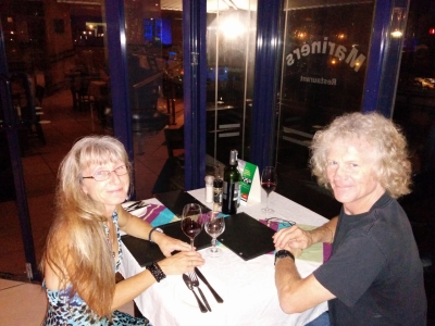
Dinner at Mariners restaurant overlooking the marina to celebrate our successful crossing. Dirona's blue deck lights are just visible in the background near the top of the picture.
|
 |
10/27/2015: Monkey
Position: -28°47.64'S, 32°4.76'E
Monkeys live in and around the marina and we see them running about in the mornings. Spitfire hasn't noticed them yet, but we're sure he'll be quite concerned when he does.
|
 |
10/27/2015: RIS car rental
Position: -28°45.54'S, 32°2.58'E
RIS car rental picked us up at the marina and drove us to their office so we could pick out a vehicle for a few weeks.
|
 |
10/27/2015: Vodacom
Position: -28°45.30'S, 32°2.92'E
We stopped in at the huge Boardwalk Mall to pickup a SIM card for cellular connectivity. We've got most of the arrival overhead out of the way now and are ready to get out and explore.
|
 |
10/27/2015: Cruisers beer
Position: -28°47.61'S, 32°4.73'E
Beer at Jacks on the Bay with some other international cruisers staying at Tuzi Gazi. Clockwise starting from Jennifer's left are Richard and Alison Brunstrom of Vulcan Spirit of Britain, Sara Osterberg Carlson and Magnus Carlson of Mahimahi of Sweden, Phil and Norma Heaton of Minnie B of Northern Ireland, and Roderick van der Meulen-Bruseker of Happy Bird of the Netherlands.
|
 |
10/28/2015: Endomeni Rehabilitation Project
Position: -28°6.16'S, 32°16.54'E
Today we visited the Endomeni Rehabilitation Project. The facility cares for injured or abandoned South African cats with the hopes of re-introducing them into the wild, and has a visitor program where you are taken into the pens and can interact with the animals.
|
 |
10/28/2015: Cats on site
Position: -28°6.19'S, 32°16.56'E
On site are currently seven cheetah, six serval, seven caracal and five wildcat. So far the program has released twenty-seven cats back into the wild.
|
 |
10/28/2015: African wildcat
Position: -28°6.20'S, 32°16.57'E
The first cats we visited were the African wildcat, the ancestor of the domestic housecat. They sure look like a normal house pet and have lovely soft fur. One distinction is that the African wildcat has all-black fur on the bottom of its paws.
|
 |
10/28/2015: Wilder wildcat
Position: -28°6.20'S, 32°16.57'E
Some of the African wildcats were accustomed to people and could be petted, but others were still pretty wild. This one would tolerate our presence, but was too wild to pet.
|
 |
10/28/2015: Caracal
Position: -28°6.20'S, 32°16.58'E
The next cats we visited were caracals. None were tame enough to be petted, but we could go inside the enclosure of one. Some caracals were being kept away from people so that they would be afraid of them and could be more successfully re-introduced into the wild.
|
 |
10/28/2015: Hiss
Position: -28°6.18'S, 32°16.62'E
This caracal was still quite wild and we could only see it (and hear it) from outside the enclosure.
|
 |
10/28/2015: Cheetah
Position: -28°6.17'S, 32°16.63'E
The next cats were Cheetahs. We were pretty amazed to be actually inside a cage with a live cheetah. Sitting it stood almost as tall as Jennifer.
|
 |
10/28/2015: Markings
Position: -28°6.18'S, 32°16.63'E
The beautiful markings of an adult cheetah.
|
 |
10/28/2015: Petting a cheetah
Position: -28°6.17'S, 32°16.64'E
Not only were we able to be inside a pen with a cheetah, we were actually able to pet one. The guide kept a close eye on the interactions and gave us careful instructions on how and where to pet the animal.
|
 |
10/28/2015: James petting a cheetah
Position: -28°6.18'S, 32°16.64'E
We still can't believe we actually petted a cheetah.
|
 |
10/28/2015: Cheetah cub
Position: -28°6.15'S, 32°16.62'E
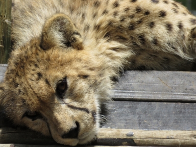
The star of the show was this cheetah cub--it was adorable.
|
 |
10/28/2015: Playful
Position: -28°6.15'S, 32°16.62'E
The cheetah cub was incredibly playful and would muss people's hair all the while purring up a storm. Here he is chewing on James' fingers.
|
 |
10/28/2015: Serval
Position: -28°6.16'S, 32°16.58'E
The fourth cat we visited were servals. They have beautiful markings that you can see on the video at https://youtu.be/bQ7Evj0J79g (0:22) The first half shows a caracal walking around it's enclosure. It has a bit of a limp because it is older and slightly arthritic.
|
 |
10/28/2015: Fake eyes
Position: -28°6.18'S, 32°16.57'E
The servil is small enough to be prey for the Verreuax's Eagle, the sixth largest eagle in the world. The markings on the back of its ears are protective to make it appear to an eagle flying above that the cat is looking back at him. This cat is substantially bigger than Spitfire, so we'll have to be very careful he doesn't get carried off.
|
 |
10/28/2015: Sleeping
Position: -28°6.17'S, 32°16.58'E
This servil apparently spends most of his time sleeping up in the tree branches. When we'd first arrived at the park and were waiting for the tour to start, two had jumped down from the trees to come see what we were doing.
|
 |
10/28/2015: Pro-Radio Marine
Position: -28°47.51'S, 32°5.05'E
We stopped by Pro-Radio Marine at the Zululand Yacht Club to inquire about diesel and checked out their well-stocked store.
|
 |
10/28/2015: Malaria
Position: -28°46.93'S, 32°6.14'E
Most of South Africa is malaria-free, including Richards Bay. But some of the game parks we might visit a little further north have a risk of malaria. So we made a doctor appointment at the Meer En See Medicross clinic to get a Malanil prescription. This is the same anti-malarial we took in Vanuatu (it's called Atovaquone/Proguanil in the US) and has a nice feature of only needing to be started a day or two in advance of exposure where most other anti-malarials require starting a week in advance.
|
 |
10/28/2015: Drinks
Position: -28°47.61'S, 32°4.78'E
We finished the day with drinks at one of the Tuzi Gazi restaurants overlooking the marina.
|
 |
10/29/2015: iMfolozi Game Reserve
Position: -28°15.05'S, 31°59.41'E
The combined Hluhluwe-iMfolizi Game Reserve is just over an hour's drive from the marina and at 96,000 hectares and is considered one of South Africa's most beautiful parks. We packed a picnic lunch and made a day-trip through the southern half, iMfolizi Game Reserve. Guided safaris are available, but we purchased a map and animal guide at the gate and had a great time self-touring.
|
 |
10/29/2015: Warthog
Position: -28°15.05'S, 31°59.41'E
We saw our first animal before we'd even passed through the gate. Three warthogs were having a drink at a little puddle near the road.
|
 |
10/29/2015: Zebra
Position: -28°15.98'S, 31°58.53'E
We weren't really expecting to see the animals so close or even necessarily see that many animals, but within minutes of passing through the gate we saw two zebras about 30 feet off the road.
|
 |
10/29/2015: Giraffe
Position: -28°15.98'S, 31°58.53'E
And a giraffe was standing next to the zebras. We were getting pretty excited at this point.
|
 |
10/29/2015: Elephant
Position: -28°16.61'S, 31°57.96'E
Five minutes after spotting the zebra and the giraffe, we came across an elephant just off the road. Amazing!
|
 |
10/29/2015: Blue wildebeest
Position: -28°15.77'S, 31°56.54'E
We drove up to a viewpoint from where we could see a huge herd of blue wildebeest.
|
 |
10/29/2015: Rhinos
Position: -28°17.62'S, 31°55.46'E
At another viewpoint, we watched a family of white rhinos make their way slowly up a dry creek.
|
 |
10/29/2015: Baboon
Position: -28°19.08'S, 31°50.84'E
This chacma baboon was gorging on berries with both hands.
|
 |
10/29/2015: Sontuli picnic spot
Position: -28°13.79'S, 31°50.73'E
We had our picninc lunch at the Sontuli picnic spot overlooking the Black Umfolizi river.
|
 |
10/29/2015: Buffalo
Position: -28°13.79'S, 31°50.73'E
A herd of buffalo were grazing in the mostly dry Black Umfolizi river below our picnic spot.
|
 |
10/29/2015: Nyala
Position: -28°13.96'S, 31°49.90'E
We stopped at another viewpoint and watched a herd of Nyala cautiously crossing the Black Umfolizi river. They could hear us a long way off and all stood rigid listening for several minutes.
|
 |
10/29/2015: Impala
Position: -28°18.13'S, 31°45.90'E
We saw several herds of beautiful impala throughout the park.
|
 |
10/29/2015: Vista
Position: -28°18.60'S, 31°52.31'E
We were so excited to see all the animals we hadn't really been paying attention to the impressive scenery.
|
 |
10/29/2015: Black rhino
Position: -28°16.98'S, 31°59.14'E
We stopped off at the Centenary Center to visit the capture bomas (enclosures) where animals are held before transfer to other parks. Here Jennifer is petting a black rhino. Black rhinos aren't out in the open plains as much as the white rhinos are, so it's somewhat less common to see them in the wild.
|
 |
10/29/2015: Baby rhinos
Position: -28°16.98'S, 31°59.17'E
These two baby black rhinos were having their afternoon feed when we arrived. They slowly chomped their way through a huge pile of leaf-filled branches.
|
 |
10/29/2015: Zebra
Position: -28°15.90'S, 31°58.56'E
We saw two more zebra shortly before exiting the park. Wow, what a day!
|
 |
11/2/2015: A brush with disaster
Position: -28°47.65'S, 32°5.02'E
Almost everyone has had a brush with disaster. Some are really big events like being standby and not making an airplane flight that crashes, or missing a bus that ends up being in a serious accident. Read more
|
 |
11/3/2015: After the storm
Position: -28°47.64'S, 32°5.02'E
The winds are still up, but the worst of yesterday's big storm now is over. This screenshot shows how we moved around at anchor for the past 24 hours (click image for a larger view). The marks on the chart show our anchor at the bottom of the shot and the outer edges of the swing area to guage if we are dragging. We use a 70kg (154lb) Rocna and had 200 ft of 7/16" high test chain that is roughly 2 lbs per foot. So, in aggregate we had around 554lbs deployed and held very well. The storm was unusually intense for Richards Bay--some are saying it was the worst in 8 years. Port Control recorded gusts of 65 knots yesterday morning. And the storm blew dry the St. Lucia estuary, a popular hippo-viewing destination just north of Richards Bay.
|
 |
11/3/2015: Mooring
Position: -28°47.65'S, 32°5.03'E
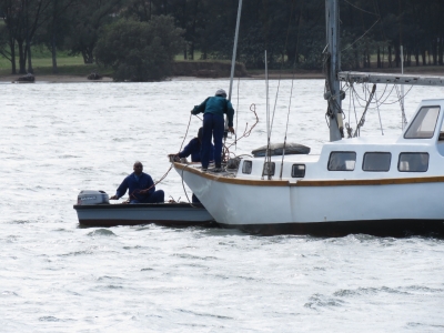
This sailboat was moored fore and aft nearby, and the forward mooring parted in yesterday's storm. A crew was out trying to re-attach it this morning. We weren't particularly tempted to go on a mooring for the storm, partly because we didn't think they were strong enough but mostly because we much prefer our own ground tackle in these situatiion. Seeing this we feel even better about our decision now.
|
 |
11/3/2015: Replacing lines
Position: -28°47.64'S, 32°5.03'E
A crew was out checking and replacing lines on the sailboats moored to the Zululand Yacht Club wave break after yesterday's storm.
|
 |
11/3/2015: Med-moored
Position: -28°47.64'S, 32°5.02'E
Now that the big storm is over, we're back Med-moored to the Zululand Yacht Club wavebreak. There isn’t sufficient space to swing if there is a large wind shift, but it was fine for the direction the storm was blowing. To secure the stern, we attached shackles to the wavebreak and ran two 75-ft lines through the shackles and back to the boat. This turned out to be a good setup as we could easily release the lines yesterday morning from on-board to come off the wavebreak when the winds picked up without have to get the stern close. Today we just re-ran the lines back through the shackles. Getting the stern up to the wavebreak to run the lines was a bit of a challenge, with 20-kt winds gusting to 30 kts. We are really glad to have hydraulic thrusters as we leaned on the thrusters for about tens minutes getting both lines tied off.
|
 |
11/4/2015: Bell Equipment factory tour
Position: -28°45.44'S, 32°1.28'E
Our Nordhavn 52 Dirona is far from light at 110,000 lbs but fully laden, the Bell B40D articulating dump truck weights considerably more at 147,000 lbs. Yesterday, I got a chance to driver this six-wheel-drive monster on the Bell Equipment test track. Read more ...
|
 |
11/5/2015: Dock repair
Position: -28°47.63'S, 32°4.74'E
We drove over to the Tuzi Gazi waterfront for lunch. The docks at the marina appear mostly repaired now after the big storm. The section that had buckled is about dead center in the picture. One of the reasons the dock is so fragile is that the piers are anchored to the bottom rather than held in place with pilings.
|
 |
11/5/2015: Dock pieces
Position: -28°47.63'S, 32°4.74'E
Various pieces of broken dock were secured to the shore around the marina area.
|
 |
11/5/2015: Yard
Position: -28°47.45'S, 32°5.02'E
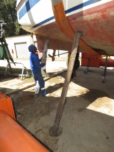
The Zululand Yacht Club has a slipway and yard where at least a couple of dozen boats are hauled out. Their boat hoist can lift up to 30 tons and is mechanically-operated rather than the more common hydrualic lifts. Here the yard crew is installing support poles under a freshly-hauled vessel.
|
 |
11/5/2015: Mclaren
Position: -28°47.53'S, 32°5.00'E
This Mclaren parked at the yacht club for the past few days gets a lot of attention.
|
 |
11/6/2015: Sunset
Position: -28°47.63'S, 32°5.00'E
There's lots of burning in the area, and we've been getting tendrils of soot on and inside the boat. The plus side is that the hazy sky makes for some dramatic sunsets.
|
 |
11/7/2015: Helicopter
Position: -28°47.63'S, 32°4.99'E
This micro-helicopter flew over the anchorage. It looks pretty fun, but doesn't appear to offer a lot of safety margin.
|
 |
11/7/2015: Dinghy tour
Position: -28°47.05'S, 32°4.77'E
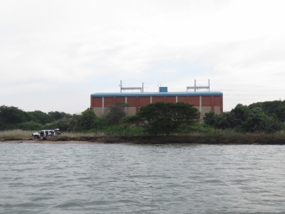
We went on a dinghy tour of the area today. The river shallows up relatively quickly, so we couldn't get very far upriver. People were fishing on shore or by boat everywhere we went.
|
 |
11/7/2015: Sea Rescue
Position: -28°47.66'S, 32°5.10'E
The Richards Bay Sea Rescue station is near where we are anchored. They have a couple of very capable-looking boats pulled up inside.
|
 |
11/8/2015: Dock
Position: -28°47.63'S, 32°5.00'E
These two men were salvaging a piece of marina dock that had likely escaped during the storm.
|
 |
11/8/2015: Pilot
Position: -28°47.63'S, 32°5.00'E
From our anchorage we can see the ships entering and leaving port. The pilots typically are dropped off and picked up near the harbour entrance by helicopter. Here a lift sling is being lowered down to the deck of a departing ship. That must be exciting when the sea is up.
|
 |
11/9/2015: Sunrise
Position: -28°47.63'S, 32°5.00'E
A spectacular Richards Bay sunrise.
|
 |
11/9/2015: iSimangaliso Wetland Park
Position: -28°23.00'S, 32°25.16'E
iSimangaliso Wetland Park is about an hour's drive north of Richards Bay and is famous for its hippo population. A popular way to see them is to take a boat tour through the estuary. We'd arrived a little early for our boat trip, so took a quick walk along the estuary boardwalk.
|
 |
11/9/2015: Hippos!
Position: -28°22.98'S, 32°25.19'E
Within minutes of stepping onto the boardwalk, we saw several hippos cavorting in the estuary. This is the first time we've seen any in the wild.
|
 |
11/9/2015: Advantage Tours
Position: -28°22.77'S, 32°24.48'E
We'd booked an 8am 2-hour boat trip with Advantage Tours, but they'd lost the reservation and had no boat scheduled until 10am. We could have gone on that later trip, but that would have broken our day up too much, so we decided to do a self-drive tour instead.
|
 |
11/9/2015: Boardwalk
Position: -28°22.93'S, 32°25.24'E
We drove over to the Estuary Beach at the other end of the boardwalk and walked back to where we'd seen the hippos earlier. They were still there, and this time they were out of the water walking ashore to a smaller lagoon.
|
 |
11/9/2015: Herd
Position: -28°22.90'S, 32°25.35'E
The hippos had tucked themselves against the west shore after crossing into the lagoon, so we walked to the opposite shore to get a better view. The water levels in the estuary are very low right now, partly due to drought. The satellite imagery shows water where we are standing on dry land.
|
 |
11/9/2015: Close-up
Position: -28°22.93'S, 32°25.30'E
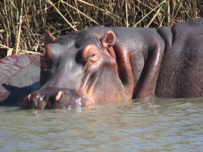
We spent ages watching the hippos and listening to their grunts and groans as the shifted about. They were wonderful.
|
 |
11/9/2015: Estuary Beach
Position: -28°22.86'S, 32°25.60'E
A late breakfast along the Indian Ocean at Estuary Beach. The scenery here is fabulous.
|
 |
11/9/2015: Hippos
Position: -28°22.93'S, 32°25.30'E
We couldn't get enough of the hippos, so went back for another look before continuing north.
|
 |
11/9/2015: Vervet monkey
Position: -28°21.86'S, 32°25.88'E
Several vervet monkeys were in the trees just along the road off Main Beach. Another new animal sighting!
|
 |
11/9/2015: Dung beetles
Position: -28°21.40'S, 32°25.19'E
iSimangaliso Wetland Park also has crocodiles--we'd seen some in the water when we crossed the estuary as we first arrived in the area. The Crocodile Center has crocodiles in captivity for viewing. We parked the car there to check it out, but found a series of nature trails that we walked instead. Large dung beetles were common along the trail.
|
 |
11/9/2015: Waterbuck
Position: -28°21.10'S, 32°25.21'E
A large herd of striking waterbuck were in a field off the trail and we were able to get surprisingly close. This is another new animal sighting for us.
|
 |
11/9/2015: Zebra
Position: -28°21.21'S, 32°25.22'E
A small herd of zebra also were just off the trail and, like the waterbuck, let us get quite close.
|
 |
11/9/2015: Mount Tabor Lookout
Position: -28°15.81'S, 32°28.98'E
Looking east to the Indian Ocean from the Mount Tabor Lookout.
|
 |
11/9/2015: Lake St. Lucia
Position: -28°15.79'S, 32°28.97'E
The view west from the Mount Tabor Lookout across the plains to Lake St. Lucia. A huge area around the like is dry, giving a good indication of how low the water levels are now.
|
 |
11/9/2015: Buffalo
Position: -28°16.25'S, 32°28.97'E
A buffalo was grazing right beside the road down to Mission Rocks. It completely ignored us as we took photos.
|
 |
11/9/2015: Mission Rocks
Position: -28°16.67'S, 32°29.17'E
Lunch perched above the Indian Ocean at Mission Rocks with the waves crashing ashore below us. We never tire of being near the water and always seek it out. We're really enjoying the diversity of the scenery in this park.
|
 |
11/9/2015: Siyabonga Craft Center
Position: -28°22.18'S, 32°24.58'E
We turned back from the Eastern Shore section of the park at Mission Rocks to save time to visit the newly-accessible Western Shore. On the way, we stopped off at the Siyabonga Craft Center for a view over the estuary. The center was partly under construction, but had some incredible art work on display.
|
 |
11/9/2015: Warthog
Position: -28°15.85'S, 32°23.49'E
A small herd of warthogs scurried off as we approached, but turned back to give us defiant stares.
|
 |
11/9/2015: Blue wildebeest
Position: -28°14.93'S, 32°23.70'E
A herd of blue wildebeest just off the road.
|
 |
11/9/2015: Black rhino
Position: -28°14.84'S, 32°23.74'E
At iMfolizi Game Reserve, we'd seen white rhinos in the wild and black rhinos in the enclosure, but this is our first sighting of black rhinos in the wild. They apparently are less commonly seen as they don't stay in the open much.
|
 |
11/9/2015: Rhino crossing
Position: -28°14.72'S, 32°23.79'E
Why did the black rhinos cross the road?
|
 |
11/9/2015: uMthoma Aerial Boardwalk
Position: -28°14.97'S, 32°24.70'E
We walked a short loop track from a parking lot to the beautiful uMthoma Aerial Boardwalk, perched amongst the treetops with view across the estuary.
|
 |
11/9/2015: Charters Creek
Position: -28°11.96'S, 32°25.01'E
You can really see how low the lake levels are. It's a long way to the water from that boat launch to the right of the dock.
|
 |
11/9/2015: Baby zebra
Position: -28°13.67'S, 32°23.32'E
We just caught a photo of this baby zebra as it hurried for cover when we were leaving the park.
|
 |
11/10/2015: Fueling
Position: -28°47.50'S, 32°4.99'E
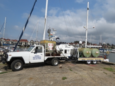
This morning we took on 1,426 gallons (5,400 L) of diesel from Pro Radio Marine at the Zululand Yacht Club. The fuel-delivery truck had a maximum capacity of 3,000L so had to make two trips. This gives you a feel for our fuel capacity: our tanks can hold 1,747 gallons (6,613 L), more than twice what you can see on the fuel truck.
|
 |
11/10/2015: World ARC
Position: -28°47.51'S, 32°4.98'E
The World ARC rally boats have been arriving over the past few days. World ARC is an annual 15-month around the world rally. ARC tends to fill up any marina they are at and their participants often get preferential treatment for shore-side services, so most cruisers try to avoid overlapping with the rally. Generally this is not difficult, but the Indian Ocean crossing through to St. Helena in the Atlantic Ocean becomes a bit of a choke point as most cruisers aim to be in South Africa before the start of the southern hemisphere cyclone season in late November and typically will spend some portion of December in Cape Town. This is our first overlap with the full fleet. A few ARC boats had arrived early into Darwin when we were there, but the full fleet didn't arrive until well after we'd left.
|
 |
11/11/2015: Richards Bay Minerals
Position: -28°32.03'S, 32°21.83'E
Today we toured Richards Bay Minerals, a mining operation just north of Richards Bay. Read more ...
|