MV Dirona travel digest for Chesapeake Bay 2016

|
Click the travel log icon on the left to see these locations on a map,
with the complete log of our cruise. On the map page, clicking on a camera or text icon will display a picture and/or log entry for that location, and clicking on the smaller icons along the route will display latitude, longitude and other navigation data for that location. And a live map of our current route and most recent log entries always is available at //mvdirona.com/maps/LocationCurrent.html. |
 |
12/10/2016: 30.6F
Position: 39°16.94'N, -76°36.51'W
It's a clear, but cold day in Baltimore with the temperature below freezing at 30.6°F (-0.8°C).
|
 |
12/10/2016: Leaving Baltimore
Position: 39°16.67'N, -76°36.05'W
Our last view of Baltimore's striking inner harbor as we head south into Chesapeake Bay. Baltimore worked out super-well for a longer-term stop—we very much enjoyed our time there.
|
 |
12/10/2016: Domino Sugars
Position: 39°16.67'N, -76°36.05'W
"It spells Domino Sugars, but it says Baltimore." (Baltimore Sun) The iconic Domino Sugars sign is the second largest neon sign on the East Coast at 120x70ft, and has been casting a red glow across the Patapsco River since 1951.
|
 |
12/10/2016: Fort McHenry
Position: 39°15.49'N, -76°34.39'W
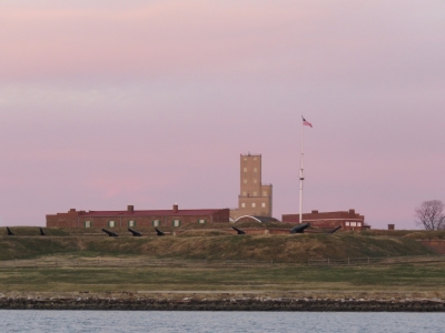
The view from sea to Fort McHenry with the Star-Spangled Banner flying.
|
 |
12/10/2016: Baltimore Lighthouse
Position: 39°3.28'N, -76°23.55'W
Baltimore Lighthouse was first lit in 1908 and still is active today. In 1964 it became the world’s first, and America's only, nuclear powered lighthouse when a sixty-watt isotopic power generator was installed to test the feasibility of such equipment in remote locations. A conventional electric generator replaced the nuclear generator a year later.
|
 |
12/10/2016: Chesapeake Bay Bridge
Position: 38°59.44'N, -76°23.18'W
Passing the twin spans of the Chesapeake Bay Bridge en route to Annapolis. The original span opened in 1952 and a second was added in 1973. "Because of its height, the narrowness of the spans (there are no hard shoulders), the low guardrails, and the frequency of high winds, it is known as one of the scariest bridges in the USA and the world." (Wikipedia).
|
 |
12/10/2016: 240V Inverter
Position: 38°58.54'N, -76°28.45'W
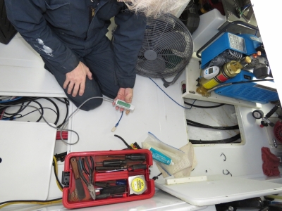
The pilot house control panel for the 240V inverter was not connecting to the inverter in the lazarette. We tried installing a spare control panel with the same result. Plugging the a spare control panel directly into the inverter in the lazarette did work, so it look like we have problem with the cable running from the pilot house to the lazarette. That will be a joy to fix.
|
 |
12/10/2016: Dinghy dock
Position: 38°58.64'N, -76°29.23'W
We anchored off Annapolis and ran the tender ashore. Here we are tied off at the dinghy dock right downtown.
|
 |
12/10/2016: Speedo Run
Position: 38°58.65'N, -76°29.28'W
We'd arrived in town during the Annapolis Santa Speedo Run. It sure was cold, but the participants seemed to be having a good time.
|
 |
12/10/2016: Fox's Den
Position: 38°58.67'N, -76°29.41'W
We had an excellent wood-fired pizza lunch at the Fox's Den gastropub.
|
 |
12/10/2016: State House
Position: 38°58.76'N, -76°29.41'W
After lunch we walked though town and past the Maryland Statehouse. Dating to 1772, it's the oldest continually-used state capitol.
|
 |
12/10/2016: Naval Academy
Position: 38°58.68'N, -76°28.97'W
The U.S. Naval Academy (USNA) offers a four-year officer training program in a 338-acre campus on the Annapolis waterfront. Established in 1845, USNA is the second oldest of the United States' five service academies after the United States Military Academy at West Point. The entire campus is a National Historic Landmark and contains many historic sites, buildings, and monuments.
|
 |
12/10/2016: Astronauts
Position: 38°58.66'N, -76°29.03'W
More astronauts have graduated from the Naval Academy than any other undergraduate institution in the United States. Jim Lovell and and Alan Shepard are among the more than 50 US Naval Academy astronauts.
|
 |
12/10/2016: Lejeune Hall
Position: 38°58.73'N, -76°28.98'W
We took a guided walking tour of the Naval Academy grounds. This is Lejeune Hall, a swimming and wrestling facility named for 13th Commandant of the Marine Corps, Lieutenant General John Archer Lejeune who graduated from the Naval Academy in 1888. The walls are covered with photos of Academy's star athletes, including Hall-of-Famers Johnny Unitas (NFL) and David Robinson (NBA).
|
 |
12/10/2016: Game Balls
Position: 38°58.73'N, -76°28.98'W
Winning game balls from the Army vs Navy matches over the years. The game was on today in Baltimore, so the campus was practically deserted during our tour. Sadly, there will be no game ball on display in Annapolis from today's game.
|
 |
12/10/2016: Chapel
Position: 38°58.90'N, -76°29.16'W
The majestic Naval Academy Chapel was completed in 1908.
|
 |
12/10/2016: John Paul Jones Crypt
Position: 38°58.90'N, -76°29.16'W
Underneath the Naval Academy Chapel is the crypt of John Paul Jones, who is considered the Father of the US Navy following his successful campaigns during the American Revolutionary War.
|
 |
12/10/2016: Bancroft Hall
Position: 38°58.93'N, -76°29.04'W
The roughly 4,000 Naval Academy students all live in Bancroft Hall, a 1,700-room facility with 4.8 miles of corridors and 33 acres of floor space that make it the largest single dormitory in the world. The initial building was constructed between 1901 and 1906 following the French Beaux-Arts architecture, and had been expanded several times since.
|
 |
12/10/2016: Bone Model
Position: 38°58.96'N, -76°29.25'W
The US Naval Academy Museum has an impressive collection of model ships, including many built by French prisoner-of-war from the bones of their beef rations. This is a model of Horatio Nelson's flagship Victory that is said to have taken fifteen prisoners two years to build out of bone scraps.
|
 |
12/10/2016: Helmet
Position: 38°58.90'N, -76°29.28'W
Each year Army vs Navy teams wear elaborate uniforms specific to the match. This is one of the hand-painted helmets from last year's match that featured seven of the historic ships that make up the U.S. Naval Fleet.
|
 |
12/10/2016: Galway Irish Pub
Position: 38°58.80'N, -76°29.38'W
After a chilly walk through the Naval Academy, we warmed up with dinner at Galway Bay Irish Restaurant and Pub.
|
 |
12/10/2016: In the Parade
Position: 38°58.63'N, -76°29.18'W
As we returned to the tender, we could see crowds of people four and five deep ringing the waterfront, and the space where we'd left our our tender was empty. Not good. We found it moved to the corner, apparently making space for the touring Annapolis Lights Parade boats that ran through the small channel. As we left, we became part of the show. We got lots of cheers, and a few jeers that our navigation lights, although the Christmas colors of green and red, didn't qualify as a light display. We were just happy to have found the tender.
|
 |
12/10/2016: Light Parade
Position: 38°58.54'N, -76°28.45'W
Our anchorage was right alongside the path of the 34th annual Annapolis Lights Parade, voted the number one Holiday Parade in the country. The TowBoatUS display was particularly appropriate, where they're actually towing a lit boat with a lit tow line. The video at https://youtu.be/0hfWcfaVIMw>https://youtu.be/0hfWcfaVIMw'>https://youtu.be/0hfWcfaVIMw shows a couple of our favourite entries.
|
 |
12/11/2016: Cable Issue
Position: 38°58.56'N, -76°28.50'W
James traced the 240V inverter cable problem to a bad ethernet connection under the lazarette floor. Hard to find but easy to fix.
|
 |
12/11/2016: Buses
Position: 38°58.54'N, -76°28.47'W
A fleet of buses arrived into Annapolis this morning, likely bringing midshipmen back from yesterday's annual Army vs Navy game.
|
 |
12/11/2016: YP 704
Position: 38°58.56'N, -76°28.50'W
Not long after the buses arrived, the Navy ships we'd seen in downtown Baltimore two days ago all returned to Annapolis.
|
 |
12/11/2016: Metal Shark
Position: 38°58.56'N, -76°28.50'W
Having toured the Metal Shark facility, we love seeing their product in use. Note the wide, unimpeded sight-lines offered by the Metal Shark design. Here the US Coast Guard is keeping an eye on things just off of our anchorage.
|
 |
12/12/2016: CPA
Position: 38°50.73'N, -76°23.87'W
We're really liking the new TimeZero Professional software. One feature that we find particularly useful is the new Closest Point of Approach (CPA) visualization. When an AIS or ARPA target is approaching from any direction, the software draws a line showing where our CPA to that target will be and that line is updated in real-time as the boats move. You can see it in the picture where the Star Pauline is passing from behind on our starboard side. Its course is veering slightly away from us and the red line between their course line and ours shows both the location of the CPA and the distance. The CPA line alone is most useful, but because the CPA line shows up even if a target is not currently visible on the screen, the CPA line also provides an early alert of an approaching target.
|
 |
12/12/2016: Iridium Testing
Position: 38°51.65'N, -76°16.59'W
We maintain an Iridium system as a backup in case our primary satellite systems are unavailable. Iridium expires their email accounts annually if you do not use it. It's annoying that a paid-for system requires you to actually use it in order to maintain the service, but that's the way it is so we test it annually.
|
 |
12/12/2016: Ava's
Position: 38°47.00'N, -76°13.41'W
We anchored for the night in St. Michael's and ran the tender ashore for an exceptional pizza lunch at Ava's Pizzeria & Wine Bar.
|
 |
12/12/2016: St Michaels
Position: 38°47.04'N, -76°13.43'W
After lunch, we walked around town a bit. St. Michael's has a large number of appealing-looking restaurants for its size and looks like a great place to spend a few days.
|
 |
12/12/2016: Chesapeake Bay Maritime Museum
Position: 38°47.25'N, -76°13.17'W
One of the reasons we stopped in St. Michael's was to visit the highly-rated Chesapeake Bay Maritime Museum. Here we are in the Boat Shop, where traditional wooden boats and accessories are built and restored.
|
 |
12/12/2016: Edna E. Lockwood
Position: 38°47.22'N, -76°13.18'W
A major project underway at the museum is the restoration of the Edna E. Lockwood, a National Historic Landmark and the last of the sailing log oyster dredges. The hull is made of pine logs, rather than sawn lumber, indicating it was built at a time when large trees were more readily available than milled timber.
|
 |
12/12/2016: Hooper Straight Lighthouse
Position: 38°47.26'N, -76°13.15'W
The Hooper Straight Lighthouse was built in 1879 about 40 miles south of the museum in Hooper Strait. The museum bought and transported it here in 1966 to save it from demolition after an automated light was installed and the house no longer needed.
|
 |
12/12/2016: Lighthouses
Position: 38°47.26'N, -76°13.15'W
Inside the Hooper Straight Lighthouse is an extensive museum detailing life in the lighthouse. This display shows seventy-one lighthouses that were installed in Chesapeake Bay. That's a lot of lighthouses.
|
 |
12/12/2016: Hydroplane
Position: 38°47.26'N, -76°13.17'W
One large building at the museum describes the recreational history of Chesapeake Bay, including locally-built hydroplanes.
|
 |
12/12/2016: Oyster Boat
Position: 38°47.30'N, -76°13.27'W
The "Oystering on the Chesapeake" exhibit features a full-size oyster boat with audio of the crew at work.
|
 |
12/12/2016: Steam Engine
Position: 38°47.34'N, -76°13.29'W
This 12ft-tall, 2-cylinder, 700HP steam engine came from a railroad tug that ferried railroad cars on car floats across the Chesapeake Bay.
|
 |
12/12/2016: Anchorage
Position: 38°47.26'N, -76°13.16'W
A view to our peaceful anchorage. The area can get quite busy in the summer, but we're the only ones here. We've always enjoyed the solitude that winter boating brings.
|
 |
12/12/2016: Winter Lights
Position: 38°47.37'N, -76°12.84'W
One upside to winter's shorter days is the nighttime lights. Whether from a passing ship, a moored boat, or a nearby house, we enjoy being snug inside with a view to lights twinkling in the distance. The show gets even better during the Christmas season, when colorful holiday light displays are put on afloat and ashore.
|
 |
12/13/2016: Mustang 2175
Position: 38°47.36'N, -76°12.85'W
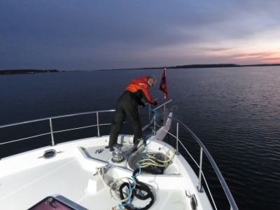
Our flotation suits are among our favourite winter boating gear. The suits are similar to ski jumpsuits, but with built-in flotation and extra insulation. We use Mustang 2175s, which are standard issue with the Coast Guard on both sides of the Canada-US border. We can toss these on over light clothing, add a pair of gloves and perhaps some ear warmers and be instantly warm in the coldest weather.
|
 |
12/13/2016: LNG Terminal
Position: 38°24.98'N, -76°21.51'W
The Dominion Cove Point LNG Terminal imports and stores liquefied natural gas (LNG). Dominion currently is constructing facilities for exporting LNG as well.
|
 |
12/13/2016: NAVAIR
Position: 38°18.37'N, -76°19.51'W
A forest of antennas at the Naval Air Systems Command headquarters at the Patuxent River mouth. Established in 1966 as the successor to the Navy’s Bureau of Naval Weapons, NAVAIR's mission is to provide full life-cycle support of naval aviation aircraft, weapons and systems operated by Sailors and Marines.
|
 |
12/13/2016: Smith Point Light
Position: 37°52.96'N, -76°10.62'W
The current caisson structure, completed in 1897, is the fifth lightouse built at Smith Point at the mouth of the Potomac River. The first three were stone towers built in 1802, 1807 and 1828 that that were abandoned due to erosion. The fourth was a screw-pile lighthouse that ice carried away in 1895. In between, three lightships also have been stationed at the point. The light was automated in 1971, among the last on the Chesapeake, and still is active.
|
|
12/13/2016: Sandy Point
Position: 37°49.41'N, -76°18.64'W
We stopped for the night behind Sandy Point and had this calm and peaceful anchorage all to ourselves.
|
 |
12/14/2016: Eye of Sauron
Position: 37°45.49'N, -76°14.07'W
In Baltimore we replaced our 8,500-10,000 lumens forward-facing light with one that is 15,000 lumens. This was our first test of the light in the dark at sea and wow, does it shed some light. It casts an incredibly bright beam that lights up the waterway in front of us without illuminating the foredeck. We were reminded of the "Eye of Sauron" from the J.R. Tolkien's Lord of the Rings.
|
 |
12/14/2016: Submarine
Position: 36°59.59'N, -76°18.87'W
Norfolk is home to the world's largest naval base with ships ranging from aircraft carriers to destroyers to nuclear submarines. Navy ships are moored on both sides of the the channel into Norfolk, with patrol craft in the air. The city also has a large and busy shipping port. As a fitting envoy, we passed a nuclear submarine heading to sea in the channel leading towards the city. A video of our arrival into Norfolk is at https://youtu.be/r4dfD1e95n8.
|
 |
12/14/2016: Waterside Marina
Position: 36°50.70'N, -76°17.57'W
Moored at the Waterside Marina in Norfolk, Virginia. The marina is nearly empty this late in the year—we're the only transient boat here. The background three large navy ships are out of the water at the General Dynamics drydocks.
|
 |
12/14/2016: Norfolk Tap Room
Position: 36°50.79'N, -76°17.54'W
We had an excellent lunch with craft beer at the nearby Norfolk Tap Room
|
 |
12/14/2016: USS Wisconsin
Position: 36°50.86'N, -76°17.64'W
The USS Wisconsin is a Iowa-class battleship on permanent display here in Norfolk. We'll be touring it tomorrow.
|
 |
12/15/2016: General Dynamics
Position: 36°50.65'N, -76°17.58'W
The pre-dawn view to the General Dynamics drydocks from our slip.
|
 |
12/15/2016: Sunrise
Position: 36°50.65'N, -76°17.58'W
A fabulous sunrise over the Berkley Bridge that crosses the Elizabeth River.
|
 |
12/15/2016: Museum
Position: 36°50.83'N, -76°17.66'W
At the Hampton Roads Naval Museum to tour the battleship USS Wisconsin.
|
 |
12/15/2016: Port Display
Position: 36°50.87'N, -76°17.69'W
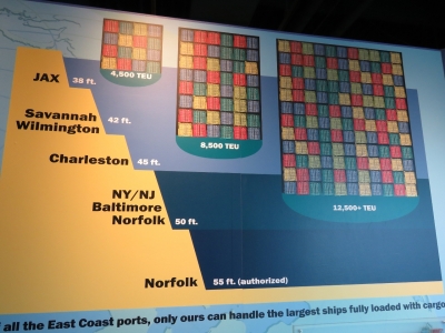
In addition to the USS Wisconsin, the Hampton Roads Naval Museum has a number of excellent naval and maritime displays including a detailed treatment of the Port of Norfolk. This display compares the ship sizes that various east coast ports can accommodate.
|
 |
12/15/2016: Shell
Position: 36°50.87'N, -76°17.69'W
The nine 16-in (406 mm)/50 cal Mark 7 guns in Wisconsin's main battery can project a 2,700 lb (1,200 kg) armor-piercing shell roughly 20 mi (32 km). This display shows compares one of those shells to a Volkswagen Beetle. The Beetle is a little bulkier and wouldn't project as well, but weighs the same.
|
 |
12/15/2016: Guns
Position: 36°50.87'N, -76°17.64'W
Looking down the bow to six of the the Wisconsin's 16-in (406 mm)/50 cal Mark 7 guns.
|
 |
12/15/2016: Boilers
Position: 36°50.89'N, -76°17.71'W
Starting this year, engine room tours of the Wisconsin are available, taking visitors through previously inaccessible areas of the ship. This is one of the eight steam boilers that power the Wisconsin.
|
 |
12/15/2016: Broadway
Position: 36°50.89'N, -76°17.71'W
The view down "Broadway", nicknamed so because it is the the longest corridor on the ship at 340ft and is full of lit panels.
|
 |
12/15/2016: Machine Shop
Position: 36°50.89'N, -76°17.71'W
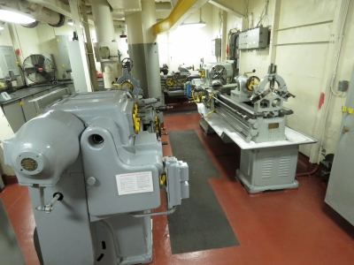
The Wisconsin has an impressive machine shop.
|
 |
12/15/2016: CEC
Position: 36°50.88'N, -76°17.70'W
We took a second "Command & Control Tour" tour through Captain's cabin, Admiral's cabin, Combat Engagement Center, Flag Bridge, navigation Bridge and Quartermaster's space. In the Combat Engagement Center (CEC) the tour included an audio and light re-enactment of a battle scenario that was quite effective.
|
 |
12/15/2016: Temperature
Position: 36°50.65'N, -76°17.59'W
It's been cold all day, but the evening temperature has dropped to 28.3°F (-2.2°C).
|
 |
12/16/2016: Naval Station Norfolk
Position: 36°56.28'N, -76°19.14'W
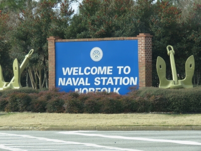
Before attending a tour of Naval Station Norfolk, we asked if we could bring a camera. We didn't consider asking if could actually use the camera though. It turned out they wouldn't let us take any pictures of the ships except from a distant parking lot where only a portion of a resupply vessel was visible. What a disappointment—we had a better view on our way into Norfolk.
|
 |
12/16/2016: VA-34
Position: 36°56.75'N, -76°16.64'W
Ob the Naval Station Norfolk tour we were allowed to take pictures of some decommissioned navy planes that included an A-6E Intruder.
|
 |
12/16/2016: If you can't beat them
Position: 36°51.19'N, -76°17.18'W
We had a super-fun evening watching the Norfolk Admirals play the South Carolina Stingrays. The Admirals are the bottom of the league and the localy commentary was "If you can't beat them, beat them" so were expecting a rather rough game. The Admirals lost 3-6, but the level of play was quite good with, surprisingly, not a single fight.
|
 |
12/16/2016: Mascot
Position: 36°51.20'N, -76°17.18'W
Jennifer with the Norfolk Admirals mascot.
|
 |
12/17/2016: Venture
Position: 37°1.55'N, -76°20.63'W
We took an Uber over to Hampton and had a good lunch at Venture Bar and Grill before heading over to the Virginia Air and Space Center.
|
 |
12/17/2016: Virginia Air & Space Center
Position: 37°1.46'N, -76°20.66'W
The Virginia Air & Space Center is the visitor center for NASA Langley Research Center and Langley Air Force Base and features exhibits spanning 100 years of flight.
|
 |
12/17/2016: Exhibit Hall
Position: 37°1.44'N, -76°20.67'W
Displays at the Virginia Air & Space Center include more than 30 historic aircraft, the Apollo 12 Command Module and the Orion PA-1 Test Vehicle. The majority of the exhibits are hung in this multi-floor gallery that can be viewed from a variety of angles. We spent ages exploring the displays.
|
 |
12/17/2016: Steering
Position: 37°1.44'N, -76°20.66'W
Jennifer at the controls of a DC-9 in the Virginia Air & Space Center. The exhibit included an entire actual DC-9, not just the cockpit.
|
 |
12/18/2016: General Dynamics
Position: 36°50.34'N, -76°17.68'W
We took the ferry across the Elizabeth River to Portsmouth today. This is a close-up view of the General Dynamics drydocks we can see from the marina.
|
 |
12/18/2016: Fresnel Lens
Position: 36°50.05'N, -76°17.77'W
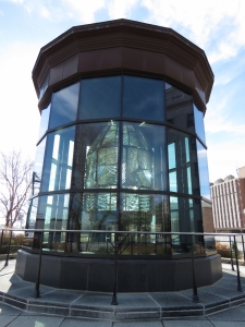
A beautiful first order Fresnel Lens from the Hog Island lighthouse is on display along the Portsmouth Waterfront.
|
 |
12/18/2016: Guads
Position: 36°50.04'N, -76°18.03'W
An exceptional lunch at Guads Mexican restaurant in Portsmouth. This was probably the best Mexican food we've had in over a year.
|
 |
12/18/2016: Lightship Portsmouth
Position: 36°50.22'N, -76°17.79'W
The Lightship Portsmouth was built in 1915 and served for 48 years off the coasts of Virginia, Delaware and Massachusetts. The ship was retired to Portsmouth in 1964 and designated a National Historic Landmark in 1989. The ship was closed for renovations, so we couldn't look inside.
|
 |
12/18/2016: Olde Town
Position: 36°50.20'N, -76°17.96'W
The Olde Town district of Portsmouth has the largest collection of period homes between Charleston, South Carolina and Alexandria, Virginia.
|
 |
12/18/2016: Temperature Swing
Position: 36°50.65'N, -76°17.58'W
The temperature soared from below freezing a couple of days ago to 76°F (24.4°C) this afternoon. We were almost too warm in just T-shirts. It's falling back down again though.
|