MV Dirona travel digest for Barbados 2016

|
Click the travel log icon on the left to see these locations on a map,
with the complete log of our cruise. On the map page, clicking on a camera or text icon will display a picture and/or log entry for that location, and clicking on the smaller icons along the route will display latitude, longitude and other navigation data for that location. And a live map of our current route and most recent log entries always is available at //mvdirona.com/maps/LocationCurrent.html. |
 |
2/3/2016: Beach
Position: 13°15.85'N, -59°38.58'W
The marina is part of a high-end resort complex with beautiful beaches.
|
 |
2/3/2016: Port St. Charles
Position: 13°15.85'N, -59°38.58'W
The marina at Port St. Charles has only a half-dozen slips. But what it lacks in space it makes up for in boat size as it caters to superyachts and can handle yachts up to 200ft.
|
 |
2/3/2016: Speightstown
Position: 13°14.93'N, -59°38.61'W
A roughly 15-minute walk brought us to the closest center, Speightstown.
|
 |
2/3/2016: Fisherman's Pub
Position: 13°15.02'N, -59°38.63'W
We had a leisurely lunch, with local Banks brews, overlooking the water at Fisherman's Pub.
|
 |
2/3/2016: Fish
Position: 13°15.02'N, -59°38.63'W
While we were having lunch, this spearfisher swam ashore with a ring of fish around his waist.
|
 |
2/3/2016: Digicell
Position: 13°14.94'N, -59°38.61'W
After lunch we stopped in at Digicell to pickup a SIM card. They're becoming a familiar brand--we've used Digicell in both Vanuatu and Fiji.
|
 |
2/3/2016: Beach
Position: 13°15.31'N, -59°38.66'W
We'd walked into Speightstown along the main road, and walked back along the beach in front of several resorts. Lots of folks were out sunning themselves and enjoying the beautiful sunny day.
|
 |
2/3/2016: Port St. Charles resort
Position: 13°15.60'N, -59°38.52'W
The resort at Port St. Charles bills itself as the Barbados Riviera. The resort complex wraps around an extensive private marina for its residents.
|
 |
2/3/2016: Four Jacks
Position: 13°15.80'N, -59°38.68'W
We got a new neighbour later in the day: the 150ft superyacht Four Jacks. The boat is 8 years old, but is so incredibly well-maintained it looks better than new. The crew immediately started cleaning it on arrival and they haven't stopped.
|
 |
2/3/2016: Sunset
Position: 13°15.80'N, -59°38.67'W
Our first Caribbean sunset, looking over the marina breakwater from our boat deck.
|
 |
2/4/2016: Boat cleaning
Position: 13°15.80'N, -59°38.67'W
We spent the two days after our arrival washing and waxing the boat--it was pretty dirty after 5,400 miles of run-time, particularly the stack. We first cleaned the stack to get the surface dirt off, then waxed it to get it all white and shiny again.
|
 |
2/4/2016: Storm plates
Position: 13°15.80'N, -59°38.67'W
We've not removed the storm plates since we installed then in Dampier, Australia. Now that we don't have any big or dangerous passages coming up, we finally took them down.
|
 |
2/5/2016: Help
Position: 13°15.80'N, -59°38.67'W
We hired two Barbadians to help with the cleaning and waxing of the boat.
|
 |
2/5/2016: Nordhavn Barbados Rendezvous
Position: 13°15.80'N, -59°38.67'W
Drinks on Dirona with Robbie and Jo Ashton, left, of Nordhavn 47 Southern Star and Jennifer and Mark Ullmann of Nordhavn 46 Starlet. They'd just crossed the Atlantic together from the Cape Verde Islands and had arrived in Barbados a few days before us. What an amazing coincidence. It was great to catch up with Robbie and Jo--we'd not seen them since Fiordland in 2014, and to meet Jennifer and Mark.
|
 |
2/6/2016: PAE interview
Position: 13°15.80'N, -59°38.67'W
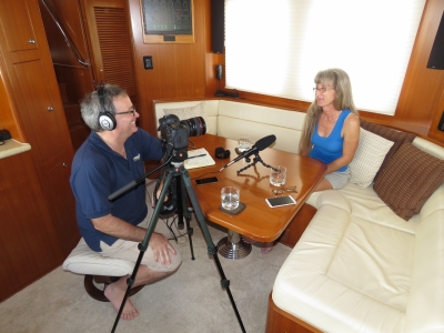
Doug Harlow from PAE came out to do a quick video interview talking about our trip and our experiences so far.
|
 |
2/6/2016: Lunch
Position: 13°15.83'N, -59°38.65'W
After a busy few days, we had a long and relaxing lunch on the deck at the Port St. Charles yacht club. The food was incredibly good food and wow, what a view.
|
 |
2/6/2016: Provisioning
Position: 13°15.83'N, -59°38.65'W
We watched the crew of the anchored superyacht La Masquerade load this big tender up multiple times with provisions. One load filled the boat entirely with bottled water stacked a couple feet above decks.
|
 |
2/6/2016: La Masquerade
Position: 13°15.80'N, -59°38.67'W
Sunset overlooking the superyacht La Masquerade that we'd watched provision earlier in the day.
|
 |
2/6/2016: Starlet
Position: 13°15.64'N, -59°38.81'W
Another Nordhavn get-together, this time dinner on Nordhavn 46 Starlet at anchor with Southern Star just off marina. They'd both originally checked into Port St. Charles, then went to anchor off Bridgetown at the southwest end of the island and returned to Port St. Charles a couple of days after we'd arrived.
|
 |
2/7/2016: Super Bowl
Position: 13°11.14'N, -59°38.32'W
The crews of Starlet, Southern Star and Dirona, and Doug Harlow from Nordhavn, went down to Surfside in Holetown to watch the Super Bowl. We had dinner on the beach enjoying the sunset over moored boats, with the surf rolling in beside us. And at nightfall on came a massive 20ft big screen with a great sound system to watch the Super Bowl. It wasn't the strongest game offensively, but this might have been one of the best spots in the world to watch it.
|
 |
2/8/2016: Southern Star
Position: 13°15.77'N, -59°38.68'W
Southern Star fueling up at Port St. Charles. We all gathered on board for Doug Harlow of PAE to video an interview with us all on our Atlantic crossings.
|
 |
2/8/2016: Lunch
Position: 13°15.83'N, -59°38.66'W
We completed the Nordhavn Barbados Rendezvous over lunch at the Port St. Charles yacht club. Starlet and Southern Star were leaving that afternoon to cruise the Caribbean and Doug Harlow was flying back to California the following day. We plan to stay and enjoy Barbados for another week or so.
|
 |
2/9/2016: Slipstream
Position: 13°15.80'N, -59°38.67'W
The 197′ super yacht Slipstream arrived today. The skipper made an impressive docking, just barely managing to clear the 150′ Four Jacks while staying off the rocks that mark the edge of the channel, rotating the stern around, and then backing into the slip.
|
 |
2/9/2016: Broken clavicle
Position: 13°5.68'N, -59°36.15'W
At the emergency clinic in Bridgetown. While watching Slipstream dock, a fender line snapped off the superyacht Four Jacks and hit Jennifer standing on the dock below hard enough to break her collarbone. Read more ...
|
 |
2/10/2016: Anti-chafe
Position: 13°15.80'N, -59°38.67'W
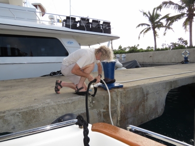
There's a fair bit of surge in the marina and even the extra anti-chafe we'd put on our lines was wearing through against the fixed concrete pier. Here James is adding more anti-chafe to protect our lines.
|
 |
2/10/2016: The Tempest Two
Position: 13°15.83'N, -59°38.66'W
As we were finishing lunch at the yacht club, super yacht Sliptream sounded their horn and around their bow came The Tempest Two. James Whittle and Tom Caulfield had left the Canary Islands on December 18th and were just now making landfall after a 55-day, 3,000nm row across the Atlantic Ocean in a 7-meter boat. This is the second time we've made a major crossing in Dirona while someone was doing the same in a small rowboat. During our first ocean-crossing, from San Francisco to Hawaii, Bainbridge Island math teacher Rory Wilson was rowing and kiting solo across in his custom-built kayak Kros. These rowers' achievements make crossing in an air-conditioned power boat look pretty boring. And in many ways, crossing an ocean in a power boat is becoming uneventful.
|
 |
2/11/2016: Surge
Position: 13°15.80'N, -59°38.67'W
Our Prostock Marine inflatable fenders are doing a great job of keeping Dirona off the concrete wall with the surge at Port St. Charles. To stabilize the boat a bit more, we've also strung two 75-foot lines from the port side to bollards on shore. We ended up with these 75ft lines almost by accident and have found them super-useful. We'd bought a 600-foot reel of line and used 450 feet for our spare anchr rode. We cut the remaining 150ft in half and the rigging deparment at the downtown Seattle West Marine did a great job of making two 75ft mooring lines out of them, with full anti-chafe. It's interesting how popular Prostock Marine is becoming. From watching the docks, its becoming the standard for superyachts. You can see why they are winning--they don't leak and can take an absolutely enormous amount of load without failing.
|
 |
2/11/2016: Garage
Position: 13°15.80'N, -59°38.67'W
The impressive tender garage on superyacht Slipstream.
|
 |
2/11/2016: Well-armed
Position: 13°15.80'N, -59°38.67'W
A police officer and two heavily armed soldiers passed through the marina today.
|
 |
2/11/2016: Mai Tai
Position: 13°15.83'N, -59°38.66'W
Jennifer having some "medicinal" rum with a Mai Tai before dinner at the Port St. Charles yacht club.
|
 |
2/12/2016: Inverter cooling
Position: 13°15.80'N, -59°38.67'W
Our Mastervolt 120V inverter has always gone into thermal shut down when the lazarette is hot. It's particularly vulnerable to early cut out when it's more than 80F outside and the sun is shining directly on the stern. It's more noticeable underway when we have more 120V load. Technically the Mastervolt specification is that the system can produce 3.6kw at 104F (30A@120V) and the lazarette is rarely over 100F but, like many specs used to sell product, it appears to be optimistic. The early cut out can be annoying both because it's unpredictable when it will happen and because the system goes down for more than a minute when it does shutdown. James decided to dig in and ensure that all four internal cooling fans are operating correctly and the system is clean and flowing air freely. All was found to be as it should be so there really was nothing to "fix". He decided to hot rod the system on the observation that the manufacturer needs to design systems that operate in wet environments and needs to compromise between good air flow and possible water damage in marine applications. Ours is not in a location where above inverter water is a possibility so he opened up two 4" vent holes in the top. The two holes alone will produce a far better cooling but we also installed two 55CFM fans so that we can get better cooling in the normal case without fans and truly exceptional cooling when they are. We tested the system for more than 5 min at over 30A and its rock solid with the fans on.
|
 |
2/12/2016: Inverter
Position: 13°15.80'N, -59°38.67'W
The inverter back in place on the lazarette wall, with the new fans visible on top.
|
 |
2/13/2016: AC condensate leak
Position: 13°15.80'N, -59°38.67'W
Air conditioning condensate drains can be a real pain. Water flows poorly through small pipes without a steady vertical drop. Unfortunately, condensate drains are almost always smaller diameter than ideal and routing in a boat simply can't always find nice steady declines. Consequently, once every year or so we'll see an overflowing HVAC unit. On the salon unit, we replaced the 3/8" condensate line with a carefully placed 5/8" line and it's never been a problem since. The pilothouse continues to get us once every 12 to 18 months. When it leaks, it's down into the ceiling over the MSR bed so we are fairly motivated to avoid this one :-). Today we worked on the horizontal flow from the PH HVAC to the section that heads down the master stateroom wall. We eliminated any "up" sections or sags in this first half of the hose run and now have good flow. However, I suspect we'll see this problem again. We will lkely have to do a phase two and go after the long horizontal run under the entire length of the MSR berth.
|
 |
2/13/2016: My Tracks
Position: 13°15.80'N, -59°38.67'W
We use Google My Tracks to generate the turquoise personal tracks on our web site. Google has recently announced that the app will no longer available after April 30, 2016. There is an amazing variety of alternative solutions out there, but it's amazing how many are poorly executed upon, don't allow exporting tracks, have tracks with large GPS errors not filtered out, or simply just have too many other features we really don't want. Jennifer got tired of me complaining about still not having found an alternative that I liked better than My Tracks so she got the open source to Google MyTracks and built MvDirona My Tracks. It's GREAT.
|
 |
2/13/2016: Dredge
Position: 13°15.79'N, -59°38.52'W
We went for a walk around the Port St. Charles resort to test the My Tracks app. This is the port dredger, moored just inside the resort canals. They keep the swing basin off the marina dredged right up to the rocks so the big superyachts have maximum maneuvering room.
|
 |
2/13/2016: Lobster Pot
Position: 13°14.95'N, -59°38.63'W
Jennifer having another medicinal Mai Tai before an exceptional meal surf side at the Lobster Pot restaurant in Speightstown.
|
 |
2/15/2016: On Dirona
Position: 13°15.80'N, -59°38.67'W
Doug Harlow just sent us this picture we just love, taken while he was out to interview us at Port St. Charles.
|
 |
2/15/2016: Almond Beach Resort
Position: 13°15.40'N, -59°38.62'W
The Almond Beach Resort doesn't currently look quite as good as their marketing picture above. Its showing signs of wear and age but is close enough to where we are moored to attract us in. We asked for a table near the pool but when the staff "discovered" we were not staying in the resort he was upset and loudly insisted he would "call security" if we didn't leave immediately. George Bush used to warn frequently of the dangers of what sounded like the "tourist threat"—this must have been it :-). Jennifer can look pretty dangerous in a dress and high heels. It's amazing how poorly a bad hiring decision can represent a business. This is particularly true in resorts and restaurants where small differences in customer experience can be the difference between a very successful business and the slow decline to failure. We instead had an excellent meal at Juma's along the water.
|
 |
2/15/2016: Juma's
Position: 13°14.91'N, -59°38.63'W
|
 |
2/16/2016: Wheels
Position: 13°15.80'N, -59°38.69'W
Jennifer's shoulder is doing better, so we rented a car for a few days to explore the island. Jones Car Rental dropped a car off right at our boat, and after filling out some paperwork, we were set to go.
|
 |
2/16/2016: Mount Gay
Position: 13°6.76'N, -59°37.60'W
Our first stop for the day was at the Mount Gay Barbados Rum factory in Bridgetown. On a guided tour through the plant, we learned about the history of rum-making in Barbados and Mount Gay in particular. Our guide said there are 180 countries in the world and they ship Mount Gay to 120 of them. We weren't allowed to take pictures inside the plant, but every bottle of Mount Gay ever shipped came from here. 85% of their production is exported. 15% seems surprisingly high to be consumed locally, but we're told rum is extremely popular with locals and visitors alike.
|
 |
2/16/2016: Tasting
Position: 13°6.76'N, -59°37.58'W
Our tour included a tasting of four rums. We were surprised to notice quite a difference in taste and smoothness between them. We also tasted a couple more later in the bar. This must have really helped Jennifer's shoulder--it was feeling much better by that evening.
|
 |
2/16/2016: Constitution River
Position: 13°5.77'N, -59°37.00'W
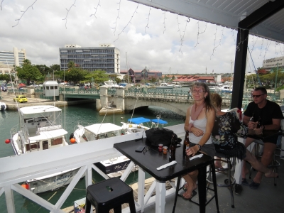
Walking along the Constitution River in downtown Bridgetown. Given the large stone breakwater, a surprising amount of swell enters the channel. Several of the moored boats were rocking substantially.
|
 |
2/16/2016: Marina Bar and Restaurant
Position: 13°5.75'N, -59°36.86'W
We had a good lunch overlooking the river at the Marina Bar and Restaurant with a great view to the action of the sportsfisher boats below. The sportsfishers come and go frequently and efficiently. This video (1:41) shows med mooring done about as quickly as it can be done: https://youtu.be/55wNnBnhsL8.
|
 |
2/16/2016: Careenage
Position: 13°5.75'N, -59°36.81'W
The moorage area along the river is called the Careenage and is mostly filled with local boats. But a couple of foreign boats were moored upriver. The restaurant we ate lunch at is visible in the background on the left.
|
 |
2/16/2016: Rastacap
Position: 13°5.75'N, -59°36.80'W
We saw plenty of rastacaps in Barbados, but only one this big.
|
 |
2/16/2016: Bridgetown
Position: 13°5.78'N, -59°36.78'W
We walked around Bridgetown a bit after lunch. The town is a real mix of old and new buildings and busy with street vendors, pedestrians and cars.
|
 |
2/16/2016: Scotia Bank
Position: 13°5.79'N, -59°36.79'W
At the bank machine to get some local cash. US cash also is accepted locally at a rate of 2:1. This is one of several Canadian banks we saw throughout Barbados.
|
 |
2/16/2016: CIBC
Position: 13°5.81'N, -59°36.91'W
The Canadian Imperial Bank of Commerce (CIBC) had a big presence in Barbados.
|
 |
2/16/2016: RBC
Position: 13°5.84'N, -59°37.04'W
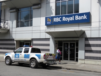
The Royal Bank of Canada also was throughout Barbados. We were surprised to see so many Canadian banks here. And this is not a new presence. RBC got started in the Caribbean in 1882, Scotia Bank in 1889 and CIBC is the relative newcomer starting in 1920. The three are by far the largest lenders in the Caribbean.
|
 |
2/16/2016: St. Mary's
Position: 13°5.92'N, -59°37.11'W
St. Mary's Anglican Church was completed in 1827. It stands on the site of Barbados' first church, St. Michael's Cathedral, built in 1641 and later relocated. St. Mary's is airy and large inside, with in impressive modern pipe organ. The original floor tiles, shipped from England, still are in place and are in remarkably good conditions.
|
 |
2/16/2016: St. Michael's Cathedral
Position: 13°5.86'N, -59°36.75'W
St. Michael's Cathedral was completed in 1784 and seats 3,000. The interior was quite ornate and full of light and the beautiful Barbados mahogany glowed. The church was at one time considered to have the widest ceiling in the world.
|
 |
2/16/2016: Boabab
Position: 13°5.94'N, -59°36.56'W
This Boabab tree at Queen's Park is estimated to be 1,000 years old and is the oldest tree in Barbados. At 90ft tall with a girth of 81ft, it's also the largest tree in the country.
|
 |
2/16/2016: George Washington House
Position: 13°4.90'N, -59°36.38'W
Jennifer at George Washington House sporting the new sling we picked up in Bridgetown. The original one from the emergency clinic was getting a little worn. 19-year-old George Washington lived on this site for two months in 1751 with his brother and guardian Laurence, who suffered from tuberculosis. We'd arrived just as they were closing for the day, so couldn't do a full tour, but checked out the grounds a bit.
|
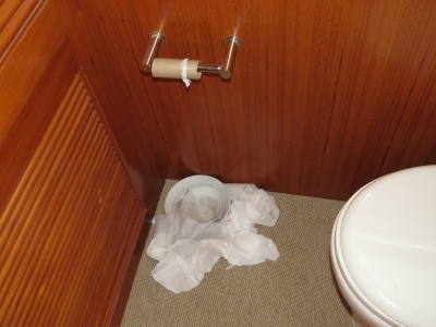 |
2/16/2016: Busy
Position: 13°15.80'N, -59°38.68'W
While we were out, Spitfire had been busy unravelling the toilet paper roll into his water dish. He occasionally does this, we've no idea why.
|
 |
2/17/2016: Harrison's Cave
Position: 13°11.10'N, -59°34.43'W
Barbados is unique amongst the Caribbean islands in not being volcanically formed. Instead, the island is made of limestone coral. Here we are on a tram to take a tour through Harrison's Cave, an underground limestone cavern near the center of the island.
|
 |
2/17/2016: Cave Tour
Position: 13°11.10'N, -59°34.46'W
The caves are at least three miles long, with several large caverns, one 50 feet high. This video shows a selection of the spectacular and extensive limestone formations inside: https://youtu.be/LiYxBTmQCaU.
|
 |
2/17/2016: Palm
Position: 13°11.10'N, -59°34.46'W
The gulley adjacent to Harrison's Cave is packed with vegetation. Jennifer, being height-challenged, tends to make things look large by standing beside them. But this palm would look huge regardless.
|
 |
2/17/2016: Monkeys
Position: 13°11.69'N, -59°34.58'W
After Harrison's Cave, we drove to nearby Welchman Hall Gully. We were lucky to arrive during the daily Green Monkey feeding. The video at https://youtu.be/baj9ON1f0rs shows the monkeys dexterously peeling the bananas and just gorging on them. With small fights breaking out, a few of the monkeys grabbed as much as they could carry and run off to a corner to eat undisturbed.
|
 |
2/17/2016: Welchman Hall Gully
Position: 13°11.38'N, -59°34.56'W
Welchman Hall Gully was formed by the collapsed roofs of caves and is one of the few accessible tropical forests in Barbados. It was incredibly lush and felt far removed from the civilization. The gulley also is connected to Harrisons Cave and was the entrance used by locals before Harrisons Cave was developed.
|
 |
2/17/2016: View
Position: 13°11.72'N, -59°34.61'W
Looking out to the east coast of Barbados from the viewpoint at Welchman Hall Gully.
|
 |
2/17/2016: Wild waves
Position: 13°13.24'N, -59°31.88'W
From Welchman Hall Gully we drove to the rugged east coast of the island to take in the surf-created rock formations. This wasn't a particularly rough day, but the waves were really pounding in.
|
 |
2/17/2016: Bathsheba Pools
Position: 13°12.84'N, -59°31.30'W
The east coast of Barbados is generally not safe for swimming or even paddling due to the high surf and strong currents. But several sheltered spots, called the Bathsheba Pools, provide reasonably safe water access. The large rock in the background is undercut and you can see clear through to the other side at one part of the base.
|
 |
2/17/2016: Soup Bowl
Position: 13°12.83'N, -59°31.31'W
The Soup Bowl is a prime surfing area in Barbados where regular international and local surfing competitions are held. Only one surfer was out while we were there. He spent a long time picking his wave, but eventually did get a nice ride.
|
 |
2/17/2016: Mushroom Rock
Position: 13°12.83'N, -59°31.30'W
Mushroom Rock is a huge offshore rock that the pounding surf has eroded into a mushroom shape.
|
 |
2/18/2016: Flat tire
Position: 13°14.15'N, -59°38.58'W
Barbadian roads are interesting, some with potholes the size of small cars. One got us and ate a tire.
|
 |
2/18/2016: Super Center
Position: 13°11.06'N, -59°38.27'W
We did a big grocery shop yesterday at Cost U Less, a Costco-like superstore near Bridgetown. Today we stopped in at the Super Center in Holetown to pickup some non-bulk-sized items and a some products we couldn't find at Cost U Less.
|
 |
2/19/2016: Fueling
Position: 13°15.80'N, -59°38.67'W
Today we cleared out and took on a load fuel prior to departing tomorrow for St. Lucia. The marina has a fuel dock, but also is setup to do in-berth fueling for the superyachts. Not having to move the boat was particularly convenient for us with Jennifer's broken collar bone. The duty-free diesel price at Port St. Charles is among the best we've seen for some time: $2.27USD per gallon. That's even better than in Cape Town, which was $2.85/gallon with a very favourable exchange rate.
|
 |
2/20/2016: Pineapple
Position: 13°15.80'N, -59°38.67'W
Jennifer cutting some fresh pineapple to have with our breakfast.
|