MV Dirona travel digest for Tonga 2013

|
Click the travel log icon on the left to see these locations on a map,
with the complete log of our cruise. On the map page, clicking on a camera or text icon will display a picture and/or log entry for that location, and clicking on the smaller icons along the route will display latitude, longitude and other navigation data for that location. And a live map of our current route and most recent log entries always is available at //mvdirona.com/maps/LocationCurrent.html. |
.jpg) |
6/16/2013: En route to Tonga
Position: -16°32.52'S, -152°28.51'W
Our French and French Polynesian courtesy flags are down, and we're now underway on the 1,300-mile run to Tonga. Conditions so far have been wonderful: calm seas, sunny skies and winds around 5 knots.
|
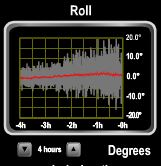 |
6/17/2013: Big seas
Position: -17°5.44'S, -154°50.96'W
Conditions deteriorated overnight: the wind picked up to steady 30 knots and we're in 8-10' seas on a 6-8 foot period. The waves mostly are on the beam, and we've experienced rolls to 23 degrees--the highest yet. Boat is doing just fine, but motion makes sleeping and moving about a challenge.
|
 |
6/17/2013: Conditions improved
Position: -17°32.03'S, -156°50.72'W
Conditions slowly improved over the course of the day, and we're now in 8' seas on 8 seconds with the seas more behind us than on the beam. Still a fair bit of boat motion, but so much better than last night.
|
.jpg) |
6/18/2013: The Dangerous Middle
Position: -18°36.02'S, -161°31.48'W
The waters between French Polynesia and Tonga are known as "The Dangerous Middle" because the South Pacific Convergence Zone (SPCZ) is particularly active here. The SPCZ is where the equatorial easterly winds and the southeast trade winds converge, producing sudden, intense squalls with winds reaching 30 to 40 knots. This is a particular concern for sailboaters, who must be able to reduce sail quickly when such a squall hits. When we first started monitoring conditions for this run, the seas were predicted to be 17'. Yikes. Fortunately we've got reasonable weather predicted for most of our run, with 7-9' seas on no less than an 8-second period. An intense low pressure system off New Zealand likely will bring 11' seas the last couple of days of the passage, but with a period of 10 seconds, that shouldn't be too bad.
|
.jpg) |
6/19/2013: The one that got away
Position: -18°44.39'S, -162°7.11'W
We found this fish inside the salon today. We keep the bottom of the salon dutch door latched closed, so it must have flown in through the top of the door. After we chucked it, Spitfire was nosing around where we'd found it. We're suprised he hadn't eaten it already--perhaps he was saving it for later.
|
.jpg) |
6/19/2013: Sunset
Position: -18°53.15'S, -162°45.10'W
Enjoying the sunset from the bow. Conditions have been wonderfully settled the last 24 hours: winds around 15 and waves about 6 feet nearly on our stern.
|
.jpg) |
6/19/2013: Palmerston Island
Position: -18°55.59'S, -162°55.33'W
We're about 50 miles south of Palmerston Island, a small inhabited atoll in the Cook Islands. We chose not to stop in the Cook Islands on this trip, partly because we are a little tight for time, and partly because they might confiscate any frozen meat and fresh fruit or vegetables.
|
.jpg) |
6/20/2013: 200 miles to go
Position: -19°12.07'S, -164°7.12'W
We're about 200 miles and one day out from Beveridge Reef, an uninhabited but anchorable atoll about 130 miles southeast of Niue. The atoll is unininhabited because no land is there--the entire reef is underwater, giving the feeling that you are anchored in the middle of the ocean. The entry apparently is straightforward, but chart looks a bit like a child's drawing, so we'll be going in by eye if we do go in. We've been pushing pretty hard right now to arrvie on the 21st, when 8' seas are expected. Seas are predicted to be up around 11' by the 22nd, so we're burning fuel to get there a day earlier and increase our chances of being able to get into the reef. We've heard that fuel in Tonga is over $7/gallon, so it will be a good lesson for us in patience in our future cruising plans.
|
.jpg) |
6/20/2013: Farthest west
Position: -19°14.06'S, -164°20.21'W
We're suprised it's taken this long, but finally at 164W we're now beyond our furthest west position of Palmyra Atoll. At 162W, Palmyra was the farthest west we'd been in Dirona until this passage to Tonga. We'd worked a long way east from Palmyra to the Marquesas Islands at 138W.
|
.jpg) |
6/20/2013: Sunrise
Position: -19°15.77'S, -164°26.75'W
Sunrise looking back over the boat deck.
|
.jpg) |
6/20/2013: Calm seas
Position: -19°22.16'S, -164°50.14'W
Spitfire's sleeping position is a good indicator of sea state. He sleeps all over the boat, but when conditions are really rough, he'll wedge himself into the circular master stateroom sink where he can't shift. Right now, conditions are pretty benign, with winds less than 10 knots and seas 6-8' on 8 seconds from the stern.
|
.jpg) |
6/20/2013: Spicy beef noodles
Position: -19°34.76'S, -165°51.02'W
Spicy Beef Noodles for dinner, one of many excellent recipes we've gotten from Sunset magazine over the years. This one is from October, 2006.
|
.jpg) |
6/20/2013: Bright night
Position: -19°37.96'S, -166°8.25'W
The moon has been bright every night, so the stars haven't been great. But Jennifer did finally get out her Peterson Stars and Planets field guide (a 1980s Christmas present from James) and was able to identify some of the constellations in the southern sky. The Southern Cross was easy to find, and she also found Centaurus, Leo, Ursa Major, Bootes, Triangulum Australe, and Corono Borealis.
|
.jpg) |
6/21/2013: Storms
Position: -19°49.38'S, -166°56.74'W
We passed through several large storm systems this morning and got an intense freshwater rinse from rainfall. This area is known for small localized squalls that really pack a punch, with winds to 30-40 knots. The nighttime sky darkened considerably as we approached, but the winds didn't pick up much beyond 15 knots as we passed through.
|
.jpg) |
6/21/2013: Cap Corrientes
Position: -19°53.23'S, -167°14.89'W
The 228m ship Cap Corrientes passed about three miles away on a northeast course, bound for Oakland, CA. This is the first boat we've seen since the morning we left Maupiti.
|
.jpg) |
6/21/2013: Muffins
Position: -19°57.10'S, -167°27.34'W
Chocolate chip muffins for breakfast.
|
.jpg) |
6/21/2013: Calm seas
Position: -20°0.82'S, -167°37.79'W
The seas were wonderfully calm for the final day into Beveridge Reef.
|
.jpg) |
6/21/2013: Unpinning the anchor
Position: -20°2.26'S, -167°41.91'W
Our bow roller has a captive pin to secure the anchor underway. Matching the anchor and bow roller holes is a little fussy however, so we use a carabiner and short length of line to secure the anchor most of the time. But on passage, we use the pin. James is removing the pin as we near land in case we need to drop the anchor quickly.
|
.jpg) |
6/21/2013: Three miles off
Position: -20°3.76'S, -167°45.97'W
A small note on the chart says the Beveridge Reef is three miles NE of where it is charted. The U-shaped radar overlay shows the shape and location of the southern end of the reef compared to the green circle where its charted, and the reef extends a good three miles north of the radar image.
|
.jpg) |
6/21/2013: Beveridge Reef
Position: -20°0.33'S, -167°47.65'W
With no land above the surface, the only way to see the reef is by the waves breaking over it.
|
.jpg) |
6/21/2013: Bow watch
Position: -20°0.13'S, -167°46.81'W
Jennifer watching from the bow as we enter. The break in the reef wasn't apparent until we were quite close to the entrance. We had a couple of hand-drawn charts from other cruisers indicating safe waypoints to enter, but we mostly went in by eye.
|
.jpg) |
6/21/2013: Visibility
Position: -20°0.05'S, -167°46.62'W
The water here is so clear that we could see the bottom in 80 feet as we followed the channel inside.
|
.jpg) |
6/21/2013: Anchored
Position: -20°1.55'S, -167°45.94'W
Anchored in the sand shallows at the south end of the reef. That line and small circle at the right of the photo is our anchor chain and rode. Rarely can you watch your anchor set from standing on the flybridge. We'd pulled the chain back under the anchor in turning the boat to test the set and it was good to see the anchor rotate over, pull down and completely bury itself after being tripped by its own rode.
|
.jpg) |
6/21/2013: Amazing
Position: -20°1.55'S, -167°45.94'W
Beveridge Reef is amazing: we're effectively anchored in the middle of the South Pacific Ocean, without a speck of land in sight in all directions.
|
.jpg) |
6/21/2013: Swim
Position: -20°1.55'S, -167°45.94'W
The color and clarity of the water over the sand makes it look like a swimming pool.
|
%20(400x300).jpg) |
6/21/2013: Shallow
Position: -20°1.55'S, -167°45.94'W
We're anchored in about 9 feet of water. With our 6'7" draft, that leaves a little over two feet under our keel. Jennifer, at the bottom of the photo, is barely able to swim under it. Fortunately we're at low tide.
|
%20(400x300).jpg) |
6/21/2013: Anchor and chain
Position: -20°1.55'S, -167°45.94'W
Free-diving the anchor--that's the chain extending towards the camera from where Jennifer is holding the anchor.
|
.jpg) |
6/21/2013: Fringing reef
Position: -20°1.55'S, -167°45.94'W
Walking out onto the fringing reef. This one is a little different from others we've been on, such as in the Tuamotus, because the water depth is about 6 feet right up to the reef, then drops to a few inches. So we didn't need to take the smaller dinghy to visit.
|
.jpg) |
6/21/2013: Clam
Position: -20°1.55'S, -167°45.94'W
Another difference between this and other fringing reefs we've visited is the sealife: the reef had excellent tidepools, and was packed with corals, fish and other sea life. Presumably this is because it's always underwater.
|
.jpg) |
6/21/2013: Achilles Tang
Position: -20°1.55'S, -167°45.94'W
A school of Achilles Tang swimming in the fringing reef.
|
.jpg) |
6/21/2013: Wave action
Position: -20°1.55'S, -167°45.94'W
Big waves pounding into the reef.
|
.jpg) |
6/21/2013: No undertow
Position: -20°1.55'S, -167°45.94'W
The waves crash into the reef and then pour over into the inside--they don't retreat back as would happen on a beach. The lack of undertow felt strange.
|
.jpg) |
6/21/2013: Shipwreck
Position: -20°1.55'S, -167°45.94'W
Wreck of a fishing vessel along the eastern side of the reef. With no land or water, Beveridge Reef is a pretty inhospitable place to be shipwrecked. Several vessels apparently have wrecked here; that the reef is 3 miles off from where charted certainly contributes.
|
.jpg) |
6/21/2013: Tereva
Position: -20°1.55'S, -167°45.94'W
Michele and Phillipe Rubiere on their catamaran Tereva. They had sailed from their home country of France across the Atlantic, through the Panama Canal and across the Pacific. Theirs was one of two other boats at Beveridge when we arrived. The other, Samuri, was the last of the Canadian-built PDQ catamarans and was owned by Swiss couple Evelyne and Christian Nigg.
|
.jpg) |
6/21/2013: Sunset
Position: -20°1.55'S, -167°45.94'W
.
|
.jpg) |
6/21/2013: Moonrise
Position: -20°1.55'S, -167°45.94'W
.
|
|
|
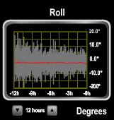
6/22/2013: Tide changes
Position: -20°1.55'S, -167°45.94'W
At low tide, the reef protects reasonably well from ocean swell, but at high tide, 2-3' waves roll through the anchorage. This 24-hour view shows the boat motion at anchor, with the times of high and low tide clearly visible.
|
.jpg) |
6/22/2013: Boat motion
Position: -20°1.55'S, -167°45.94'W
Dirona was moving quite a bit at anchor. We toured the lagoon by dinghy and didn't find anything substantially better, but where we were the waves were hitting us on two different angles. So we moved around to the south east corner and put out the flopper-stopper. That didn't entirely stop the motion, but helped substantially.
|
_cropped%20(400x300).jpg) |
6/24/2013: Diving
Position: -20°1.00'S, -167°45.22'W
After seeing the water clarity and the healthy fringing reef, we really wanted to dive at Beveridge. We ran the dinghy outside and investigated a few locations outside the reef. But the current was ebbing quite strongly, with 6-8' closely packed waves in the entry channel, and we couldn't find a place that was both sheltered from the southwesterly swell with little current. Getting blown offshore away from the dinghy would not be fun around here. The lagoon is mostly in the 30' range throughout, and the most likely spots inside were near the channel, but currents there also were quite strong. In the end, we anchored in about 25' in the lee of a coral head off the south side of the channel. We swam into the current around the head until we started to get pulled the other way, then returned. It was hard work, but we enjoyed the dive. Jennifer is taking a break holding onto a dead coralhead.
|
_cropped%20(400x300).jpg) |
6/24/2013: Puffer
Position: -20°1.00'S, -167°45.22'W
Yellow-gold variation of the Guineafowl Puffer.
|
%20(400x300).jpg) |
6/24/2013: Coral
Position: -20°1.00'S, -167°45.22'W
The coral here was healthy and diverse.
|
%20(400x300).jpg) |
6/24/2013: Butterfly fish of the day
Position: -20°1.00'S, -167°45.22'W
Several Big Longnose Butterflyfish, with a Moorish Idle in the middle
|
.jpg) |
6/27/2013: Niue
Position: -19°21.79'S, -170°37.04'W
We're just past Niue, an island nation that is amoung the world's smallest states on the largest block of coral. Cruisiers do visit there--both sailboats at Beveridge were heading there next--but no all-weather anchorage is available and boaters must be ready to move should the winds and waves pick up from the west where the main anchorage is.
|
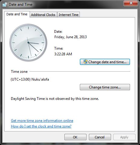 |
6/28/2013: My Friday is before your Friday
Position: -18°37.35'S, -173°41.38'W
... unless you're also in Tonga. At GMT+13, Tonga is the first country west of the International Dateline, so it's the first place that sees the new day. One of our navigation computers only supports up to GMT+12 (Fiji), so we had to set to its timezone to GMT-11 to at least get the time correct, but the date is one day behind. Probably the programmers figured that GMT-11 is the same as GMT+13, so why bother supporting it? Sadly, it's not. :(
|
.jpg) |
6/28/2013: Land ho
Position: -18°33.88'S, -173°52.48'W
We can just make out Tonga to port shortly before 5am.
|
.jpg) |
6/28/2013: Approach to Neiafu
Position: -18°39.94'S, -174°4.32'W
The approach to Neiafu, in the Vava'u Group, is through a deep and winding five-mile river-like channel. James was off watch during the last stages of our approach to Tonga and got up as we entered the enclosed waters. He felt like he'd gone to sleep in the ocean and woke up on the Amazon.
|
.jpg) |
6/28/2013: Bow watch
Position: -18°39.61'S, -174°1.06'W
Spitfire likes to be extra careful as we approach a new port.
|
.jpg) |
6/28/2013: Liloa
Position: -18°39.12'S, -173°59.15'W
The monthly supply ship Liloa, from New Zealand, arriving into Neiafu behind us.
|
.jpg) |
6/28/2013: Clearing through
Position: -18°39.12'S, -173°59.15'W
Filling out clearance paperwork. The whole process was quite efficient: we'd docked round 7:50am, the officials came to Dirona shortly after 9:00am, after they had cleared in the Liloa, and we were cleared through well before 10am.
|
.jpg) |
6/28/2013: Cleared through
Position: -18°39.12'S, -173°59.15'W
Swapping our qurantine flag for a Tonga courtesy flag.
|
.jpg) |
6/28/2013: Market
Position: -18°39.12'S, -173°59.15'W
The 'Utukalongalu Market, just up from the main wharf. We bought some delicious pineapple and other fresh produce there.
|
.jpg) |
6/28/2013: Neiafu
Position: -18°39.12'S, -173°59.15'W
Looking east down the main road in Neiafu. Cars drive on the left side of the road here, although that seemed somewhat arbitrary based on some of the traffic we saw.
|
.jpg) |
6/28/2013: Neiafu Harbor
Position: -18°39.12'S, -173°59.15'W
Looking west from town across Neiafu Harbor. Dirona is on the dock beyond and slightly right of the the Liloa.
|
.jpg) |
6/28/2013: Church
Position: -18°39.12'S, -173°59.15'W
One of at least two major churches in Neiafu. Religion is important to Tongan culture--most Tongans attend church regularly.
|
.jpg) |
6/28/2013: Looking east
Position: -18°39.12'S, -173°59.15'W
Looking east from town across Neiafu Harbor. Moorings has a major charter facility nearby.
|
.jpg) |
6/28/2013: Fueling
Position: -18°39.12'S, -173°59.15'W
We'd run hard from French Polynesia, so took on a small amount of diesel upon arriving into Tonga at $6.19USD/gallon. Diesel can be purchased duty-free for about 25% less, but only after obtaining our exit papers, so we'll fill up completely just before leaving.
|
.jpg) |
6/28/2013: At anchor
Position: -18°39.49'S, -173°59.45'W
We were fueled by noon and then moved over to an anchorage across from town. Most of the other transient boats were anchored on the north side of the harbor--we had this spot pretty much to ourselves. It was a lovely, tranquil anchorage. Tongans are quite musical and we often heard choirs and other singing during our stay. And at night, the lights of the town twinkled across the calm harbor waters.
|
.jpg) |
6/28/2013: Aquarium Cafe
Position: -18°39.49'S, -173°59.45'W
That evening, we had a great dinner with local Tongan beer at the Aquarium Cafe at the east end of town. Mike Smith, our clearance agent with Yacht Help Tonga, owns the cafe with his wife Lori. Mike did an excellent job in getting us cleared in and fueled efficiently.
|
.jpg) |
6/29/2013: Sunrise
Position: -18°39.49'S, -173°59.45'W
Sunrise over Neiafu Harbor.
|
.jpg) |
6/30/2013: Topography
Position: -18°40.56'S, -174°3.18'W
The Vava'u Group is the northern third of Tonga, and consists of 60 islands over a sea area about 300nm square. This is about the same size as the San Jaun Islands, for those familiar with the Seattle area. And if feels that way too: we're cruising sheltered waters with winding waterways and little islets everywhere. Many of the islands have dramatic bluffs like this one.
|
.jpg) |
7/1/2013: Ovaka Island
Position: -18°44.86'S, -174°5.45'W
After spending a couple of nights in Neiafu Harbor, we headed out to expore the Vava'u Group. Our first anchorage outside the harbor was off the eastern end of Ovaka Island. A lovely beach headed the anchroage, and we had an exellent view southeast across the reefs. The next morning a local was gathering, presumably food, from the reef at low tide.
|
.jpg) |
7/1/2013: Charts
Position: -18°44.85'S, -174°5.44'W
The charts for Tonga aren't nearly as accurate as for French Polynesia, although certainly better than the near non-existent chart for Beveridge Reef. We've been overlaying the radar onto the chartplotter a lot here to gauge our position more accurately. We're the red circle in the center of the screen. The overlay in red shows the land from the radar image, and the brown is where the chartplotter shows land. This indicates that the chartplotter shows us slightly further to the east than we actually are. We don't use radar overlay frequently, as it tends to obscure chart information, but here it's quite useful.
|
.jpg) |
7/1/2013: Vaka'Eitu Island
Position: -18°43.22'S, -174°6.08'W
Looking south across the anchorage at Vaka'Eitu Island. We're enjoying the relaxed pace in the Vava'u group, where the anchorages are only an hour or two's run apart and we're not going to sea everytime we move the boat.
|
.jpg) |
7/2/2013: Last pamplemouse
Position: -18°43.22'S, -174°6.08'W
The last of our delicious French Polynesian pamplemouse (local grapefruit). We've had some almost every morning since arriving in French Polynesia. Fortunately we have some excellent Tongan pineapple to replace it.
|
.jpg) |
7/3/2013: Port Maurelle
Position: -18°41.99'S, -174°2.04'W
We'd left Vaka'Eitu Island planning to anchor at Port Maurelle. But so many boats where there, and the anchorage is around 100' deep with little swing room, that we went to look for another anchorage. The winds have been blowing in the 20s and 30s from the southeast for the past few days, and the other possible anchorages in the area were pretty exposed, so we ended up back at Port Maurelle. We found a spot along the southern shore, away from the other boats, in about 100' with sufficient room to swing with lots of rode.
|
.jpg) |
7/3/2013: Sunset
Position: -18°41.99'S, -174°2.04'W
Sunset from Port Maurelle.
|
.jpg) |
7/4/2013: Impeller
Position: -18°41.99'S, -174°2.04'W
The remains of the impeller, part of the generator's raw water cooling pump. Impellers are wear items, and will fail quickly if the inlet is blocked. The last failure, in the summer of 2011 in Prince William Sound, was caused by a jellyfish plugging the raw-water strainer. We're not sure the cause of this one, but the impeller sure was torn up. When replacing an impeller, if 100% of the part isn't there, its important to take apart the cooling system and find the rest or something will plug later. Typically the pieces will be found on the inlet to the heat exchanger, and that's where all these pieces were found.
|
.jpg) |
7/4/2013: Nuapapu Island
Position: -18°41.99'S, -174°2.04'W
We went out on a dinghy tour of the area. Many of the islands in the Vava'u Group have steep shore that erosion has undercut, like these along the northern tip of Nuapapu Island.
|
.jpg) |
7/4/2013: Mariner's Cave
Position: -18°41.99'S, -174°2.04'W
Another goal of our dinghy tour was to scout for dive sites. Mariner's Cave is a well-known snorkelling site near the northwest tip of Nuapapu Island. The cave is not visible from the surface--the entrance is underwater and snorkelers dive down and under the lip to come up inside. Locating the cave turned out to be easy however: two large pink arrows marked the spot.
|
.jpg) |
7/4/2013: Kitu Island
Position: -18°41.99'S, -174°2.04'W
Undercut along the north shore of Kitu Island.
|
.jpg) |
7/4/2013: Whalewatching
Position: -18°41.99'S, -174°2.04'W
Whalewatching is popular in Tonga, part of the winter breeding grounds for Humpback whales.
|
.jpg) |
7/4/2013: Swallows Cave
Position: -18°41.99'S, -174°2.04'W
Inside Swallows Cave, at the northwest tip of Kapa Island. This one we could easily run the dinghy into. The cave was about about 75 feet in diameter and height, with many stalegmites. We could clearly see the bottom in 40 feet. It was wild.
|
.jpg) |
7/4/2013: Second cave
Position: -18°41.99'S, -174°2.04'W
Slightly around to the west was another cave, smaller than Swallows, with a large opening in the ceiling. We could easily run the dinghy inside this one as well.
|
%20(400x300).jpg) |
7/4/2013: Swallows Cave Dive
Position: -18°41.99'S, -174°2.04'W
We returned back out to Swallows Cave for a dive and anchored the dinghy inside in 40'. On this dive, we dropped down to 40' and explored the inside of the cave, then swam up to the lip at the cave entrance, out of the cave, and down the sheer wall face that runs to the sea floor about 80-100' below. This photo was taken looking out the cave entrance.
|
%20(400x300).jpg) |
7/4/2013: Bubble-like coral
Position: -18°41.99'S, -174°2.04'W
We saw a lot of different kinds of coral here than we'd seen before, such as this one that looked like clumps of bubbles. Unfortunately we don't have a good coral indentication book.
|
%20(400x300).jpg) |
7/4/2013: Brain coral
Position: -18°41.99'S, -174°2.04'W
Large red brain coral.
|
%20(400x300).jpg) |
7/4/2013: Feather duster coral
Position: -18°41.99'S, -174°2.04'W
The walls outside the cave contained many feather duster corals.
|
%20(400x300).jpg) |
7/4/2013: Along the wall
Position: -18°41.99'S, -174°2.04'W
Diving the wall at about 65 feet. The visibility was excellent, with lot of fish and coral life. We saw a couple of fish we'd not seen before, but couldn't get close enough for a photo, including a Midnight Snapper in its intermediate form. This is an unusual-looking fish, with white stripes below the pectoral fin and white spots above.
|
_cropped%20(400x300).jpg) |
7/4/2013: Big coral
Position: -18°41.99'S, -174°2.04'W
Jennifer swimming past a coral that is perhaps 4 feet in diameter, outside the entrance to the second cave we'd visited earlier.
|
%20(400x300).jpg) |
7/4/2013: School
Position: -18°41.99'S, -174°2.04'W
Looking back to that same coral, with a massive school of small silver fish above.
|
%20(400x300).jpg) |
7/4/2013: Diving the second cave
Position: -18°41.99'S, -174°2.04'W
Looking out from inside the second cave. Not much life was inside the cave, due to the lack of light, but diving inside it was still pretty wild.
|
%20(400x300).jpg) |
7/5/2013: Entering Mariner's Cave
Position: -18°41.99'S, -174°2.04'W
We dove Mariner's Cave the next morning--Jennifer is diving under the ledge to enter the cave. Anchoring the dinghy there is a little challenging, as only a narrow shelf of anchorable depths extends offshore, then the bottom drops steeply to over 100 feet. We anchored just at the cliff edge, with room to swing towards shore, then dove the anchor and wrapped the chain around a rock to keep it from swinging off the shelf. In Papeete, we'd purchased 15' of stainless steel chain to replace our the 9' of galvanized, mainly to reduce wear on the rope portion by keeping it out of the coral. The extra length came in handy here.
|
%20(400x300).jpg) |
7/5/2013: Mariner's Cave dive
Position: -18°41.99'S, -174°2.04'W
Looking back out from inside the cave. The swim through the entry tunnel isn't very far--perhaps 10-12 feet--before we surfaced inside the cave. It would be an easy free dive, that apparently lots of people make. But it would feel pretty uncomfortable without scuba gear, heading into the unknown like that with an overhead obstruction.
|
_cropped%20(400x300).jpg) |
7/5/2013: Anemone fish
Position: -18°41.99'S, -174°2.04'W
After exploring the cave, we dove the wall outside. Visibility was again excellent, with lots of soft coral and fish life.
|
.jpg) |
7/5/2013: Fanau Tapu Pass
Position: -18°43.83'S, -173°58.75'W
From Port Maurelle, we travelled through Fanua Tapa Pass to the eastern side of the Vava'u Group. The pass is narrow and shallow, and none of the markers we'd read about were in place. But we were able to run through relatively easily by sight, with GPS waypoints from one of our cruising books as a guide (Ken's Guide to the Kingdom of Tonga).
|
.jpg) |
7/5/2013: Kenutu Island
Position: -18°41.71'S, -173°55.81'W
We continued to the eastern extrem and anchored off the north end of Kenetu Island. Here we got a chance to enjoy the results of those big winds we've been experiencing the past few weeks: huge waves slamming into the gap north of Kenetu Island. This photo was taken from the boat at anchor.
|
.jpg) |
7/6/2013: Preventative maintenance
Position: -18°41.71'S, -173°55.81'W
A minor issue that can stop a diesel cold is failure of the accessory drive belt or idler pulleys. The drive belt drives the engine cooling pump and so is mission critical. But it is a wear item. Two failure modes are possible: the first being the belt itself wears out, the second being bearing failure on one of the pulleys it rides over. So we check it every year. On this check, there's 3,300 hours on the belt so even though it looks close to perfect we decided to change it. Also, the bearings on one of the two idler pulleys is just starting to show wear. When we went to replace that, we discovered our spare pulley is for a different belt arrangement. Our engine has two large alternators and consequently has non-standard belt routing. We have three spare idler pulleys on order and will replace one of them later in the year.
|
.jpg) |
7/6/2013: Waxing the stack
Position: -18°41.71'S, -173°55.81'W
One of our many uses of the boat deck crane. Cleaning and waxing the stack is a challenge on our boat. We have steps that run up the forward side, but its almost impossible to reach the aft side. So James uses a combination of a climbing harness and the boat deck crane to lift him up to the top of the aft side of the stack.
|
.jpg) |
7/7/2013: Fonua Unga Pass
Position: -18°45.80'S, -173°57.73'W
We travelled south through Fonua Unga pass to the outer islands. With the winds blowing SE in the 20s for the past few days, the waves really piled up in the shallow water just outside the pass. We saw probably 12' seas on 3-4 seconds--that was exciting. And the charts didn't seem very accurate here, so we had to gauge the shallows partly by sight based on where waves were breaking.
|
.jpg) |
7/7/2013: Shipwreck
Position: -18°48.83'S, -173°58.63'W
Sailboat aground on the reefs north of Luatafito Island. Hard to say how it ended up there, but we really noticed chart innacuracies cruising the outer islands. The charts seemed just like a hint of what might be there. Mike & Julie Gannaway of New Zealand tells us that their country make free raster charts of the area available that are much more accurate than the vectors we've got.
|
.jpg) |
7/7/2013: 'Euakafa Island
Position: -18°45.44'S, -174°2.63'W
View to the beach off the northwest end of 'Euakafa Island from our anchorage. We'd hoped to find an interesting anchorage in the outer islands, but conditions everywhere were too rough. So we continued back inside the main group and found an excellent and calm spot between the reefs off the western side of 'Euakafa Island
|
.jpg) |
7/8/2013: Aisea Beach
Position: -18°42.02'S, -174°0.27'W
Conditions deteriorated overnight, with fairly large waves on the beam rolling into the anchorage. We probably would have been fine with the flopper-stopper out, but the motion kept us awake much of the night and we were eager to find calmer waters this morning. We left at first light and found a wonderfully sheltered spot off the southern tip of Pangaimotu Island. Several boats already were anchored in the more common anchorage to the northeast, but we much prefered this spot just off the bluffs. Depths were around 100' and then dropped quickly to several hundred, so careful placement was required to give us adequate swing room. But the effort was worth it: we had a sheltered jungle-side anchorage all to ourselves with the bird calls filling the air.
|
.jpg) |
7/8/2013: Cows and canoe
Position: -18°42.02'S, -174°0.27'W
Out on a dinghy tour around the bay. These cows were standing on a small beach along the north shore.
|
.jpg) |
7/8/2013: Cave
Position: -18°42.02'S, -174°0.27'W
Jennifer standing in a cave near the anchorage. Besides the solitude, the interesting shoreline also attracted us to the anchorage.
|
.jpg) |
7/8/2013: At anchor
Position: -18°42.02'S, -174°0.27'W
This was an excellent anchorage. We didn't realize how much the winds were blowing, and how sheltered we were here, until we got to the western side of the bay and the waves were 2-3 feet.
|
.jpg) |
7/8/2013: Pocket beach
Position: -18°42.02'S, -174°0.27'W
We landed the dinghy on this small beach near the anchorage with a great view west.
|
.jpg) |
7/9/2013: Vaipua Lagoon
Position: -18°38.37'S, -173°59.99'W
Tucked into a cove around the corner from Viapua Lagoon. We really liked this anchorage and were surprised no other boats were here. The cove had excellent protection from the prevailing southeast winds and jungle surrounded us in three sides.
|
.jpg) |
7/9/2013: Betsy Ross
Position: -18°38.37'S, -173°59.99'W
Possibly the Betsy Ross, anchored farther out in the bay, was a deterrent to other boats. Whatever the reason, we enjoyed haveing our cove all to ourselves.
|
.jpg) |
7/9/2013: Low tide
Position: -18°38.37'S, -173°59.99'W
At low-tide, a good dozen locals came out to work the exposed shallows.
|
.jpg) |
7/10/2013: Into the lagoon
Position: -18°38.37'S, -173°59.99'W
At high tide the next morning, we set off in the dinghy to explore Vaipua Lagoon. Depths were at least 8 feet as we passed under the causeway, so we easily could have enteried at a mid-tide.
|
.jpg) |
7/10/2013: Fishers
Position: -18°38.37'S, -173°59.99'W
Fishers inside the lagoon, working a net from an outrigger canoe.
|
.jpg) |
7/10/2013: Shallows
Position: -18°38.37'S, -173°59.99'W
At the head of the lagoon, an enticing passage seemed to lead to possibly another lagoon. But we couldn't find any route with more than 2 feet of water. And with the tide falling, we didn't want to get trapped.
|
.jpg) |
7/10/2013: Church
Position: -18°38.37'S, -173°59.99'W
A small church inside the lagoon. The grounds were beautifully maintained and the setting was idyllic.
|
.jpg) |
7/10/2013: 'Otuanga'Ofa
Position: -18°39.12'S, -173°59.16'W
We returned back out of the lagoon and continued towards Neiafu. The Tongan passenger ship 'Otuanga'Ofa was at the dock there.
|
.jpg) |
7/10/2013: Cargo
Position: -18°39.12'S, -173°59.16'W
The 'Otuanga'Ofa was loading and offloading a wide variety of cargo, including this crated pig.
|
.jpg) |
7/10/2013: Aquarium Cafe
Position: -18°39.12'S, -173°59.16'W
We returned to the Aquarium Cafe for a delicious pizza lunch. And we bought two more to go to freeze for later. Frozen pizza heats up nicely in the oven on a pizza stone.
|
.jpg) |
7/10/2013: Freezer alarm
Position: -18°38.37'S, -173°59.99'W
The lazarette freezer high-temperature alarm went off early in the evening. The temperature had climbed from around 7F to nearly 20F in 45 minutes. The compressor definately wasn't running, but we couldn't find anything wrong. After we checked all the power connections and cyled the power, fortunately the compressor came back on and the temperature is on the way back down again. The alarm is setup through Maretron N2KView using a Maretron temperature probe we installed inside the freezer. We set an alert if the temperature hits 18F or higher. Without that alarm, we'd have lost the freezer contents. We still need to keep an eye on this problem though.
|
.jpg) |
7/11/2013: More pineapple
Position: -18°39.12'S, -173°59.16'W
Washing some just-purchased market pineapple in a bleach-and-water bath to kill any insects before bringing them inside.
|
.jpg) |
7/11/2013: Fueling
Position: -18°39.12'S, -173°59.16'W
Filling the tanks with duty-free fuel for the run to Fiji.
|