MV Dirona travel digest for New Zealand to Brisbane 2014

|
Click the travel log icon on the left to see these locations on a map,
with the complete log of our cruise. On the map page, clicking on a camera or text icon will display a picture and/or log entry for that location, and clicking on the smaller icons along the route will display latitude, longitude and other navigation data for that location. And a live map of our current route and most recent log entries always is available at //mvdirona.com/maps/LocationCurrent.html. |
 |
5/14/2014: 948mb low
Position: -41°15.74'S, 173°16.89'E
We've been studying the weather patterns in preparation for our run across the Tasman Sea to Brisbane. This is a combined surface pressure and 1000-500mb thickness chart from the Center for Land and Atmospheric Studies. The southern ocean really is different: the innermost purple circle at the bottom is a 948-mb low. How's that even possible?
|
 |
5/15/2014: Jello
Position: -41°15.74'S, 173°16.88'E
Making Jello mixed with canned peaches for the run to Brisbane. When the weather kicks up, this snack is easy on the stomach.
|
 |
5/15/2014: Fueling
Position: -41°15.48'S, 173°16.93'E
Filling up the fuel tanks from a Mini Tanker truck. Because we're leaving the country, we can purchase the fuel GST-free.
|
 |
5/15/2014: Storm plates
Position: -41°15.61'S, 173°16.86'E
After fueling, we moved over to a temporary berth before clearing out later today. We docked on the port-side to install the storm plates. These protect large expanses of glass against the force of rough seas. The starboard side ones are easier to install, as we have a walkway there. For the port side ones, we either go up against a dock, or use the dinghy.
|
 |
5/15/2014: Deadlights
Position: -41°15.62'S, 173°16.86'E
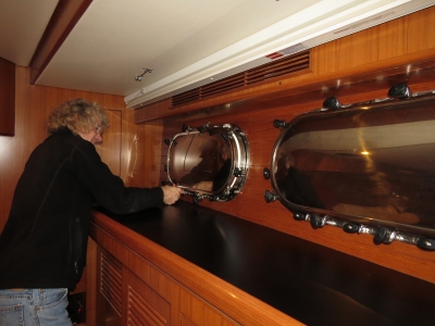
We also installed the deadlights over the lower windows throughout the boat. Deadlights are metal covers that fit over a porthole to provide additional strength over the glass alone.
|
 |
5/15/2014: Export certificate
Position: -41°16.36'S, 173°17.39'E
We can bring Spitfire from New Zealand into Australia quarantine-free, but he needs to be examined, treated for parasites, and an export certificate filled out. Dr. Todd Halsey of Halifax Veterinary Clinic is giving Spitfire a health exam. Spit of course passed, but that didn't make him any happier about being there.
|
 |
5/15/2014: Clearing out
Position: -41°15.58'S, 173°16.84'E
At the New Zealand Customs dock to clear out. Once cleared, we have to leave immediately and can't make any stops.
|
 |
5/15/2014: Sunset
Position: -41°15.34'S, 173°16.86'E
And we're underway for Brisbane-only 1,360 more miles to go. We expect the trip to take 7-8 days, depending on conditions. We should have a high pressure system in place for most of the run, with waves up to 3 meters as we set out. But the period should be at least 10 seconds and they should flatten within a day or so.
|
 |
5/15/2014: Moonlight
Position: -40°57.49'S, 173°12.32'E
The moon is so bright, it looks like a spotlight is shining on the deck. Conditions are wonderfully calm and smooth so far, with winds below five. But we've not yet left Tasman Bay.
|
 |
5/16/2014: Morning conditions
Position: -39°55.67'S, 172°9.79'E
Conditions remain good. We picked up some swell from the NE as we were leaving Tasman Bay, and put that on the stern when we turned northwest. The roll gauge shows the slow increase in roll motion and the sudden drop when we turned. We're now in 3-4-meter seas from the SW, but on a 10-12-second period, so just big lumbering seas that pass gently under us. Winds have been below five knots pretty much since leaving Nelson. Roll motion has slowly increased, but not to anything significant, and the ride still is quite comfortable. The waves have impacted our speed though--we've dropped almost a knot at the same RPM as when running in Tasman Bay. The latest forecasts still indicate a lessening of the seas and a high pressure system for much of the run.
|
 |
5/16/2014: Moonset
Position: -39°49.11'S, 171°58.40'E
.
|
 |
5/16/2014: Sunrise
Position: -39°49.11'S, 171°58.40'E
.
|
 |
5/16/2014: Afternoon conditions
Position: -39°9.16'S, 170°50.82'E
The wind has come up to nearly 20 knots. The seas are smaller than this morning--about 2 meters down from 3-4--but a little closer together at around 9-10 seconds. Boat motion has increased a bit, but still is not too bad. The weather models still indicate conditions will improve, so we don't expect much worse.
|
 |
5/17/2014: 1,000 miles left
Position: -37°33.23'S, 168°13.66'E
We're now down to 1,000 left for Brisbane. If we can maintain current speed of about 8kts, we'll arrive on Thursday the 22nd.
|
 |
5/17/2014: Calm seas
Position: -37°29.45'S, 168°7.75'E
The sky is clear blue, the winds have dropped to around 15 knots, and the waves are down to 1-2-meters on about 12 seconds. Conditions are excellent--we could do this forever.
|
 |
5/17/2014: Sunset
Position: -37°4.30'S, 167°28.51'E
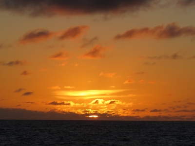
Conditions remain calm--this is among the nicest passages we've made.
|
 |
5/18/2014: Traffic
Position: -35°58.89'S, 165°51.73'E
Early this morning we saw another boat about six miles away--the only one we've seen since leaving Tasman Bay. Probably it was fishing, as it had bright lights and was running somewhat randomly at around 3 knots.
|
 |
5/18/2014: Breakfast
Position: -35°55.48'S, 165°46.80'E
Fresh-baked cinnamon buns for breakfast.
|
 |
5/18/2014: Conditions
Position: -35°18.65'S, 164°53.87'E
Conditions keep getting better and better--it feels like we're on a lake. Winds are less than 5knots and seas have barely a ripple. Sydney-based James Ellingford, of Nordhavn 62 Pendana, tells us this is a 150-year record for such calm conditions in the Tasman.
|
 |
5/18/2014: Courtesy flag
Position: -35°14.43'S, 164°47.82'E
Taking down the New Zealand courtesy flag. We've been flying that for a while.
|
 |
5/18/2014: Calm seas
Position: -34°51.07'S, 164°14.46'E
Everyone is enjoying the calm conditions. At sea, Spitfire usually wedges himself somewhere to limit his motion, but he doesn't have to on this run.
|
 |
5/18/2014: Sunset
Position: -34°53.32'S, 164°17.67'E
Sunset over still waters--the colors remind us of a Roy Vicars print. Later at night, we could see the stars reflected perfectly in the water surface.
|
 |
5/19/2014: Australian waters
Position: -33°37.97'S, 162°36.37'E
We're just over halfway there, and are entering Australian waters 200 miles off Lord Howe Island. We'll be passing about 45 miles north of Lord Howe Island, and about 50 miles south of Elizabeth and Middleton Reefs. A direct route from Nelson to Brisbane actually intersects Lord Howe Island, so we had to adjust the route slightly to the north to avoid it.
|
 |
5/19/2014: Speed
Position: -33°2.77'S, 161°49.82'E
We're always experimenting with different ways of using the boat, for different reasons. The Tasman Sea has a reputation for being a difficult body of water, and more than one boat hasn't returned from it. So on this passage, since we have lots of fuel and the trip is only 1,300 miles, we decided to make the most of our weather window and trade some fuel for safety in getting across quickly. Ironically, the conditions are the best we've ever seen on any crossing any time. Even the currents are sometimes with us. All those positive influences come together and have us travelling between 8 and 9 knots and getting in a day earlier than we expected.
|
 |
5/19/2014: Sunset
Position: -32°36.69'S, 161°15.95'E
Conditions remain excellent--winds are below 5 knots with a low swell. The only thing that's changed is the wind and swell are now coming from the northeast instead of the southwest.
|
 |
5/20/2014: Lord Howe Island
Position: -31°23.89'S, 159°45.74'E
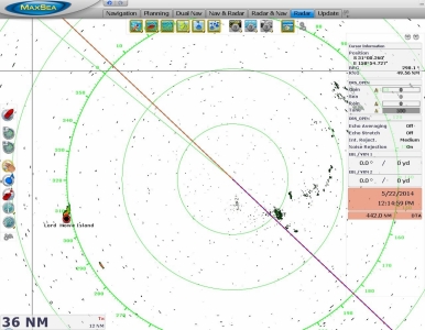
Lord Howe Island, visible on radar 36nm away. The smaller radar target more to our southwest is Balls Pyramid.
|
 |
5/20/2014: Land ho!
Position: -31°18.23'S, 159°38.78'E
Our first sighting of Australian land: the peaks of Lord Howe Island about 30 miles to our southwest. The island is a port of entry, but we'd rather reach the mainland without delay.
|
 |
5/20/2014: Brisbane time
Position: -31°16.03'S, 159°36.07'E
We switched over to Brisbane time this morning--two hours earlier than New Zealand time. Conditions remain excellent--light winds with a low swell.
|
 |
5/20/2014: Last of the kibbles
Position: -30°21.62'S, 158°23.99'E
Australia's list of restricted items includes pet foods of any kind (dry, canned, etc.), so we're carrying enough to just reach Australia. The product we've been using in New Zealand is an Australian export, so we might be able to keep what little remains. But more likely one of our first tasks after clearing through will be securing more kibbles for Spitfire.
|
 |
5/20/2014: Evening stroll
Position: -30°21.24'S, 158°23.43'E
Most evenings, Spitfire takes a 30-second walk out the port-side pilothouse door, across the Portuguese bridge, and back in the starboard-side door. He doesn't seem to want to spend much time outside, but he really wants to do this quick one. We generally have the doors shut when underway, but open them briefly while Spitfire takes his walk.
|
 |
5/20/2014: Dinner
Position: -30°17.83'S, 158°18.47'E
Sear-roasted salmon with sesame oil for dinner--the last of our New Zealand salmon as we work down our supplies.
|
 |
5/20/2014: Current
Position: -29°56.61'S, 157°47.76'E
After making such excellent time most of the trip, we've hit a major negative current. At the same RPM and conditions as before, we're now down to 6.4 knots from 9.3. And the fuel economy is dramatically worse too: from 1.04 nm/gal to 0.68.
|
 |
5/21/2014: Warmer
Position: -29°28.42'S, 157°6.69'E
The water temperature is now nearly 80F and the air temperature is steady in the 70s night and day. That's a big increase from Nelson a week ago, where the water temperature was in the mid 60s and the air temperature at night was in the low 50s.
|
 |
5/21/2014: Watch schedule
Position: -29°13.03'S, 156°43.71'E
We've been evolving our shift schedule over time and have settled on one that seems to work well: Jennifer has the helm from 8 to 11:30pm and then again from 3am to 6:30am (or whenever James wakes up). We have breakfast together, then Jennifer sleeps for about 4-5 hours. This gives us both a good amount sleep, and a reasonable amount of time together, particularly around the evening meal.
|
 |
5/21/2014: Lunch
Position: -28°45.15'S, 156°2.48'E
Lunch on the flybridge about 200 miles out of Brisbane. We've had a few queries as to why we chose to land in Brisbane rather than Sydney. It's a combination of factors. Cyclone season says we cannot be north of Brisbane in the southern hemisphere summer, which is also the best times to visit Tasmania. So we plan to head to Brisbane, spend some time there, then sail north and spend three months or so in the Whitsundays and Great Barrier Reef. Then as summer approaches, we'll head south to Sydney for Christmas/New Years and after that spend a couple of months in Tasmania before heading across the Australian continent on the south side. It's a combination of weather restrictions/optimizations and places we want to visit.
|
 |
5/21/2014: Speed
Position: -28°32.93'S, 155°45.34'E
The speed continues to be all over the place but we're running at an incredible 9.9 kts right now. A positive current helps, but we do have to admit than many a dinosaur was harmed on this crossing. Our boat isn't super fast due to having only 48' of waterline so, on this passage, we made up for the length with diesel.
|
 |
5/21/2014: Traffic
Position: -27°53.69'S, 154°50.50'E
As we near mainland Australia, we're starting to see a fair bit of north-south traffic off the coast.
|
 |
5/22/2014: North Stradbroke Island
Position: -27°23.65'S, 154°8.76'E
This screenshot shows the radar image overlayed over the chartplotter view. North Stradbroke Island is showing up on radar 32nm slightly to our southwest. We'll pass north of Moreton Island, to our northwest, before turning into the channel through Moreton Bay and into the Brisbane River. We'll be clearing through at Rivergate Marina, about ten miles upriver.
|
 |
5/22/2014: 'Q' flag
Position: -27°18.14'S, 154°1.10'E
Raising the yellow 'Q' flag to indicate that we've not yet cleared through and request clearance when we land.
|
 |
5/22/2014: Sunrise
Position: -27°17.74'S, 154°0.56'E
Finally we can see the ships out there after only being able to see their navigation lights, or just see them electronically on radar or AIS.
|
 |
5/22/2014: Josephine Maersk
Position: -27°13.54'S, 153°53.28'E
.
|
 |
5/22/2014: MCP Hamburg
Position: -27°13.54'S, 153°53.28'E
.
|
 |
5/22/2014: Land ho!
Position: -27°10.88'S, 153°48.59'E
Our first sighting of the Australian continent: Moreton Island 20nm away.
|
 |
5/22/2014: Cape Moreton
Position: -27°1.77'S, 153°31.22'E
Light atop Cape Moreton to our southwest as we near the north end of Moreton Island.
|
 |
5/22/2014: Fishing vessels
Position: -27°1.13'S, 153°29.76'E
Fishing vessels working the shoals off Moreton Island.
|
 |
5/22/2014: Northeast Channel
Position: -26°57.46'S, 153°20.06'E
The main shipping is Northwest Channel, farther to the west. We're taking Northeast Channel into Moreton Bay to shave a couple of hours off the run and hopefully reach the customs dock during regular business hours, and before nightfall. Northeast Channel mainly is used by local craft, but is well-marked. At low tide, we never saw less than twenty feet as we passed through the shallowest section near this entrance buoy.
|
 |
5/22/2014: Comboyuro Point
Position: -26°59.00'S, 153°20.25'E
Heading south through Northeast Channel towards Comboyuru Point on Moreton Island, visible in the distance. We got a big push from the incoming tide, and at times were running over 11 knots.
|
 |
5/22/2014: Moreton Island
Position: -27°4.14'S, 153°21.56'E
Shipwrecks on Moreton Island, placed there as a breakwater. Moreton Island is the third largest sand island in the world. Fraser Island, 100nm to the north, is the largest, and North Stradbroke Island, directly to the south, is the second largest.
|
 |
5/22/2014: Kota Juta
Position: -27°15.94'S, 153°13.54'E
The Kota Juta heading into port.
|
 |
5/22/2014: Port of Brisbane
Position: -27°21.03'S, 153°10.80'E
Brisbane is an incredibly busy port and makes our home port of Seattle look almost a little backwater.
|
 |
5/22/2014: PB Murrumbidgee
Position: -27°21.69'S, 153°10.34'E
Beautiful tractor tug PB Murrumbidgee.
|
 |
5/22/2014: Lifeboat drill
Position: -27°23.10'S, 153°9.44'E
Lifeboat drill on one of the ships at the port.
|
 |
5/22/2014: Coal
Position: -27°23.51'S, 153°9.27'E
Huge piles of coal were alongside the port here.
|
 |
5/22/2014: Bunker V
Position: -27°24.13'S, 153°9.09'E
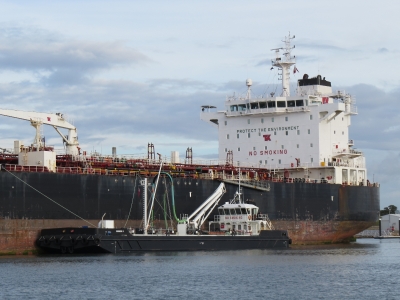
The Bunker V alongside the bulker Hugli Spirit.
|
 |
5/22/2014: Pelican
Position: -27°24.98'S, 153°8.54'E
Pelican on the Brisbane River.
|
 |
5/22/2014: Rivergate Marina
Position: -27°26.69'S, 153°6.32'E
Moored to the quarantine dock at Rivergate Marina. The clearance process was smooth and efficient, and Spitfire is now officially an Aussie.
|
.png) |
5/22/2014: Welcome to Australia!
Position: -27°28.24'S, 153°2.32'E
A welcome to Australia from James Ellingford, of N62 Pendana. Thanks James!
|