|
Christmas in Desolation Sound
In the
winter of 2002, rather than our usual trip to the Gulf Islands, we instead
traveled to
Desolation
Sound. For those unfamiliar with the area, here's a
detailed map. You can also
read about this
trip in the December, 2003 issue of
Pacific Yachting.
Upon
learning of our trip, everyone's first question is always about the weather. It
was cold of course — we did not spend any time sitting around in shorts — but we
saw very little fog and few storms. The skies were overcast much of the time,
but it did not rain everyday, in fact, as you will see from the pictures, we had
several mornings and afternoons of blue sky.
We really love winter boating, when the crowds have fallen off and are
replaced by huge flocks of wintering seabirds. There are always a few
boats in and around the Gulf and San Juan Islands all year round, but
once we had left Oak Bay, we were to see only one other pleasure craft
underway during our entire trip. While we did not expect to see
many boats, we were anticipating that a few locals might be there at
least. However my Dad, who lives in nearby Campbell River, says all his
friends thought we were crazy to be going. Crazy or not, it was a
wonderful experience.
For our winter boating tips and techniques see
Winter Boating. And for general
boating tips and techniques, along with many wonderful, little-known
anchorages, see
Waggoner sister
publication,
Cruising the
Secret Coast. |
.jpg)
|
|
 |
It was
a crisp, sunny winter day when we crossed the Juan de Fuca Straight to clear
customs in Victoria. There was little wind and the seas were very calm. This
is the view looking west across the golf course as we approach Oak Bay
Harbour. We spent the first night at Montague Harbour Marine Park in the
Gulf Islands, which was unusually deserted - not even one other boat. |
|
 |
A gale
blew in the Strait of Georgia all night, and at least one commercial boat
opted to go through the Gulf Islands the next morning, so instead of heading
right out through Porlier Pass as we had originally planned, we went up
through Dodd Narrows to Nanaimo. That way the tide would be with the wind
when we ventured out. The conditions turned out to be amongst the calmest we
have seen though, almost dreamy. The picture at left is just north of the
Sisters Island light station, looking west to Vancouver Island. |
|
 |
After
passing a sleepy Lund and a very deserted Copeland Islands Marine Park, we
continued on to Desolation Sound. Upon rounding Sarah Point, the view down
the sound of the Coast Mountains was positively stunning. This is always a
wonderful sight in the summer, but in the winter, the peaks are much more
impressive with their coating of snow. We were expecting dramatic scenery,
but were literally shocked at the vista that greeted us as we turned
eastward.. |
|
 |
We were
both eager to stop first at Prideaux Haven in Desolation Sound Marine Park,
the most popular destination in the park and extremely crowded in the
summer. The last time we were here, there were at least fifty boats inside,
with float planes constantly arriving outside to shuttle boaters between
their vessel and the cities. It was noisy and busy on that summer afternoon,
but today, one week before Christmas, the cove is silent and empty. We
kept expecting another vessel to show up, but none did. |
|
 |
From
our anchorage inside deserted Prideaux Haven, the view of Mount Denman
(centre in the earlier picture) jutting a snow-encrusted tooth 6,590 feet
into a clear blue sky was particularly impressive. At this point we were
feeling pretty pleased with ourselves. |
|
 |
The
following day we stopped in at Refuge Cove to see about getting some fuel,
as the closer it got to Christmas, the more difficult this would be. We
arrived at a sleepy community, with a few homes clearly occupied, but the
fuel dock and store were closed. We walked around for a bit and someone
eventually came down to open up for us, so we got fuel and water and were
all set for the next several days. The last time we were here in the summer,
it was so busy that we had to wait for a spot at the fuel dock. Not so
today. |
|
 |
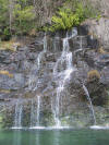
Our
next stop was the waterfalls at Teakearne Arm. We were anticipating that the
flow would be much more active in the winter, but were delighted to
encounter not one, but two waterfalls gushing over the cliff. Anchoring
here, where the bottom drops off steeply to over 100', is no easier in the
winter than the summer however. After much effort, we eventually managed to
get a good set in 120', letting out 450' and pulling back to the point just
east of the falls, where we stern tied to an old logging ring. |
|
 |
Our
efforts were rewarded with not only a spectacular view of the falls, but a
beautiful sunset as well. We bundled up and sat up on the flybridge with a
glass of wine as the sun set and the landscape turned purple and blue. |
|
 |
The
following day dawned clear and blue, with sea smoke drifting above the water
surface near the falls. We took the dinghy over to the park dock to walk up
to the top of the falls and to Cassel Lake, which feeds them. This is the
view looking west down Teakerne Arm. Note the white colour of the wood on
the dock surface - it was thick with frost and very slippery. |
|
 |
Cassel
Lake, in the summer a warm and popular swimming spot, is chilly and
uninviting this time of year. The lack of temperature was more than made up
for by the tranquil surroundings however. |
|
 |
The
extra waterfall made it quite difficult to make our way to even the top of
the falls, let alone around to the lake. As visible in the picture, the
water is flowing quite rapidly. |
|
 |
We left
Teakearne mid-morning to take advantage of the clear skies and head deeper
into the Coast Mountains, expecting some spectacular views and were not
disappointed. This is the view down Price Channel, north of the Redonda
Islands, of Mounts Grazebrooke and Whieldon at the entrance to Toba Inlet. |
|
 |
We were
originally planning to head up Toba, but by this time it was nearing 4pm and
dusk (one of the distinct downsides of winter boating is the reduced number
of daylight hours, although the upside is that you don't have to stay up
very late to see the stars), so we continued our Marine Park tour and
stopped at deserted Walsh Cove. The view is looking northeast from the
anchorage across Waddington Channel to snow-dusted Mount Bunsen on East
Redonda Island. There has been no wind and the water is exceptionally
smooth. |
|
 |
The
following day we returned to Desolation Sound Marine Park and anchored in
Laura Cove. We bundled up and made a dinghy tour of the anchorages, still
expecting to find someone in Prideaux, but once again the entire area was
deserted. Melanie Cove was packed with moon jellyfish - literally thousands
and thousands - with gonads coloured white, pink, salmon and purple. |
|
 |
Continuing our Marine Park tour, Roscoe Bay was our next destination. The
tides would be very high all day for the next several days, so entering and
exiting over the shallow bar at the entrance would not pose an issue -
nonetheless, a bow watch was in order. We anchored just off a beautiful lacy
waterfall on the northern shore, which is just a trickle in the summer. |
|
 |
This is
the view looking east across the bay of a snow-covered Dudley Cone (left)
and Mount Crawshay (right).
The bay was empty
except for Dirona and six pairs of Surf Scoters, with their
distinctive white forehead and skull patch, who were swimming with a pair of
Barrow's Goldeneye, as is frequently their custom. |
|
 |
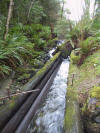
At the
head of the bay, an old logging flume channels the water emptying from
nearby Black Lake into Roscoe Bay, the rainforest slowly taking over at the
sides. The water was running very swiftly within. We beached the dinghy
nearby and went for a walk to the lake. The trail, an old logging road, was
covered by a thick carpet of moist and decomposing leaves.
|
|
 |
The
rainforest on either side of the trail was in fully glory. Steeped with
life, it looked, felt, and smelled magnificent. We found many different
types of mosses and lichens throughout, in all shades of vibrant green.
This healthy mass
of Tangle Moss was growing on a tree hanging over trail. |
|
 |
Black
Lake was extremely calm and still, with bits of fog catching in the trees on
the other side. Later in the evening, fog from the lake could be seen slowly
seeping into Roscoe Bay. |
|
 |
The
next morning we rounded the south side of Cortez Island into the teeth of a
winter storm — we saw gusts to 40kn. It wasn't a surprise, as we had been
listening to the weather reports, but it was certainly exciting. We had to
tack to the SW before turning north into Sutil Channel - it was rough enough
that the ferry heading from Cortez over to Quadra was doing the same. At
times the seas were close to 10', but
Dirona handles very well in such conditions, so we had no problems,
although it was a little disconcerting rising up, up, up in a following sea
when a huge wave passed beneath us. The picture at left is in much calmer
conditions looking south towards Surge Narrows from Waiatt Bay, but it still
looks pretty bleak for a normally calm area. |
|
 |
The
next Marine Park on list was Octopus Islands, where we would spend Christmas
Eve and wake up on Christmas Day. The park looked rather exposed and
uninviting when we arrived, but we found shelter and solid holding in the
middle of an empty Tentacle Cove. The storm grew that night to blow 55knots
at Cape Mudge, while we saw gusts of 35. Instead of Christmas music, we
listened to the Vessel Traffic channel as the ships signed off early and
everyone exchanged Christmas salutations. |
|
 |
Christmas is the day for eating, so we started off with fresh-baked Danishes
and lazed in the cabin with our coffees, watching a huge flock of Common
Goldeneye foraging for their own meal nearby. We couldn't imagine a better
place to be for Christmas Morning. |
|
 |
It was
misty and overcast in the warm front that followed the previous night's
storm. We left our anchorage and came through Hole in the Wall, pictured at
the western entrance, and back into the warmer waters below the rapids.
Instead of the more typical ten-degree difference of the summer, the water
temperature at the Octopus Islands was 44.5 compared to 46 beyond the
rapids. |
|
 |
We
anchored that night in Von Donop Inlet, empty and silent save for the
soulful call of a loon when we first arrived. It was a wonderful setting for
our Christmas dinner, which consisted of peppercorn-crusted roast beef
tenderloin (see 12/2004 issue of
Pacific Yachting for
recipe), potatoes 'Da Delfina', boiled fresh artichoke with
lemon-butter, and a bottle of Mondavi cabernet. If nothing else, we are
certainly maintaining the holiday eating tradition. |
|
 |
The
next morning dawned clear and calm, and as there were several more storms
forecast, including a 980mb low over the southern tip of Vancouver Island
tomorrow morning, we decided to take advantage of the weather break and head
south to Princess Louisa Inlet (top right in this
map). We would need fuel for that trip, and first stopped at Powell
River, which was closed. Egmont was fortunately open, so we able to refuel
at this friendly outpost before heading deeper into Jervis Inlet. |
|
|
[Next] |
|