.jpg)
From the soaring peaks of the Marquesas Islands in French Polynesia, we travelled 465 miles to the barely-above sea level Tuamotu Archipelago. Of the seventy-eight islands that make up this archipelago, all but two are coral atolls. The Tuamotos are renowned for excellent diving, and we agree: the diving there is out of this world.
One of the challenges of cruising these islands is the high-current passes, of four-to-eight knots, that must be negotiated in order to enter the atoll. You want to enter near slack water, but since slack water occurs at similar times across the group, this can make timing a run between islands a little difficult. Another challenge is that large coral heads are spread like land mines through the largely navigable, but generally uncharted atolls. The anchor chain (you need to be all chain here) can wrap around the coral heads as the boat moves about and be hard to disentangle. We favored the windwards side of the atolls, where the bottom has more sand and fewer coral heads, so we’re less likely to wrap the anchor chain. But the downside was that the windward side generally was further from the dive sites at the entry, and the atolls generally weren’t charted between the entry and the windward side, so we had to run across carefully. So long as we weren’t running directly into the sun, we were able to easily see most hazards well in advance.
The effort to visit the Tuamotus most defintely was worth it. Besides the excellent diving, we loved exploring the atolls and especially walking out to the edge of the fringing reef and watching the waves pounding over. And we generally had most anchorages to ourselves, compared to the far more busy Marquesas Islands.
 |
One of the top dive sites was Anse Amyot–click here for our blog entry. And our log for the trip follows, or click on the image at left for a live map-based version. On the live-map page, clicking on a camera or text icon will display a picture and/or log entry for that location, and clicking on the smaller icons along the route will display latitude, longitude and other navigation data for that location. And a live map of our current route and most recent log entries always is available at http://www.mvdirona.com/maps/LocationCurrent.html. |
.jpg) |
5/2/2013: Lunch
Lunch on the flybridge en route to the Tuamotu Archipelago. The winds are below ten and the waves below five, both with us, as is the current. Conditions are wonderfully comfortable and smooth, and should remain this way for the 465-mile run.
|
.jpg) |
5/3/2013: Rain
Judging by the color of the sky just after sunrise, we were in for a deluge. But only a little rain actually fell on us.
|
.jpg) |
5/3/2013: Tepoto
First sighting of land in the Tuamotus: Tepato, a small island less than a mile across within the Iles de Desappointement group. The Tuamotus Archipelago consists of 78 islands, all but two being coral atolls. The islands are known for amazing diving with excellent visibility and abundant fish, creature and coral life. But the cost of entry is navigating high-current passes into the atolls, plus the risk of wrapping the chain around coral heads at anchor.
Our charts don’t show any detail on Tepato, and the group name doesn’t encourage exploration. There did appear to be a radio tower and a few buildings ashore, so perhaps it is inhabited. |
.jpg) |
5/4/2013: Sunrise
We’ll be arriving at Raroia late this morning. We initially were planning to make landfall at Makemo, about fifty miles further, over three nights. But we were making such good time that we’d have to slow down in order to arrive during daylight. So we decided to stop earlier at Raroia instead since the timing for entering the pass works out well. SV Soggy Paws Tuamotus Compendium includes a Seven Seas Cruising Association (SSCA) report that Raroia is one of the best pass dives in the Tuamotus, with 50-150 sharks on every dive as well as 4-foot groupers, tuna, large parrotfish and many smaller species. And excellent diving on the walls outside the pass as well.
Conditions on the run have been wonderful: winds below fifteen the whole way, with the waves rarely higher than three feet. We could do this for weeks. |
.jpg) |
5/4/2013: Muffins
Freshly-baked chocolate chip muffins for breakfast.
|
.jpg) |
5/4/2013: Takume
The outline of Takume, an atoll 5.5 miles northeast of Raroia, showing up clearly on the radar as the elongated oval between 4 and 5 o’clock. The other targets are rain systems.
|
.jpg) |
5/4/2013: Raroia entry
Dirona has landed at Taroia and its pretty amazing. We came in at 11:30 which was predicted to have 2.3 kts incoming current. We got uncomfortable on the way in with the current feeling like way more than 2.5 kts, so we turned the boat 180 degrees and headed back out. On the way back out against the current, it felt much more in control and we felt it probably was around 2.5 knots. With that data point, we went back in and it was super easy.
|
.jpg) |
5/4/2013: Crossing the atoll
Once inside, the only part of the atoll charted is the channel along the western edge to a small village, but the better anchorages are along the east shore through uncharted waters. We started towards the village, but the water clarity was amazing and we felt like we were pretty safe spotting coral heads, so we turned back from the village and went across to the east side of the atoll. The depths were 100-150 feet the entire way and crossing the atoll was pretty easy overall.
|
.jpg) |
5/4/2013: Channel to village
To better see coral heads and other underwater hazards, we navigated into Raroia from the flybridge helm. The entry channel and the route to the village were well-marked and the charts accurate.
|
.jpg) |
5/4/2013: Bow watch
Bow watch as we cross the uncharted atoll. We’ve done a lot of bow watches in cruising northern B.C. waters: we’ve been to many places that weren’t charted at all, with high- current, shallow entries and the cruel rock outcroppings of the Pacific Northwest. So this felt pretty familiar, except of course that the water is 88F, we can see the bottom in 70 feet, and we’re looking out for coral heads instead of rocks.
|
.jpg) |
5/4/2013: Looking for coral
James at the flybridge looking for coral heads while Jennifer is at the bow. We found the coral pretty easy to see from several hundred feet away, and picking a safe route overall was not difficult.
|
.jpg) |
5/4/2013: Hinano time!
We’re now in an amazing anchorage off a palm tree-covered island with the surf rolling in on both ends of it.
|
.jpg) |
5/4/2013: Exploring ashore
Looking west across the atoll from the islets at our anchorage.
|
.jpg) |
5/4/2013: Coconuts
Opening one of the three coconuts we brought back from the islet.
|
.jpg) |
5/5/2013: Coconuts and coffee
Coconut meat and coffee at sunrise. The coconut is delicious–we’ll need to get more as we’re going through it so fast.
|
.jpg) |
5/5/2013: Squall
We ran the dinghy west across the lagoon to dive the channel area. Partway across a squall came up that reduced visibility to thick fog-like conditions. The atoll is large enough that we couldn’t see either side anymore and had to navigate by compass.
|
.jpg) |
5/5/2013: Diving
Using the dinghy’s depth sounder, we located a wall north and outside of the channel that plummeted from 50 to over 200 feet. We anchored the dinghy in about 35 feet and got ready to dive. We’d gotten a little cold coming across in the squall, and the 88 degree water felt wonderful–like a warm bath. The next surprise was the visibility and the coral life–both were simply astounding.
|
.jpg) |
5/5/2013: Coral
Coral blanketed the bottom and was incredibly healthy and diverse.
|
.jpg) |
5/5/2013: Reef Shark
White-tip reef shark swimming under the dinghy over that amazing coral reef.
|
.jpg) |
5/5/2013: Anemonefish
Anemonefish swimming in the upper right of the first anemone that we’ve seen since the Pacific Northwest.
|
.jpg) |
5/5/2013: Butterfly fish
Threadfin butterfly fish. We’d returned back out for a second dive, and again a squall came up again as we crossed and we needed the compass. This time the wind had picked up enough from the west enough and generating big enough waves that we didn’t feel safe anchoring the dinghy on the outside of the entry channel. So we tried just inside on the north side. The sea life and visibility wasn’t nearly as good as on the outside, but we still had an excellent dive.
|
.jpg) |
5/5/2013: Lemon Shark
Sicklefin lemon shark. These sharks, unlike the white- and black-tipped reef sharks, are considered dangerous and need space.
|
.jpg) |
5/5/2013: Damselfish
Yellow-tailed dasycluss damselfishes, grouped around several coral heads.
|
.jpg) |
5/5/2013: Emporor anglefish
We saw one Emporer Angelfish on the first dive and a few more on the second dive. Years ago, when we maintained a 600-gallon saltwater system in our house, a large Emporer Angelfish was our favorite fish in the tank.
|
.jpg) |
5/6/2013: Sunrise
.
|
.jpg) |
5/6/2013: Waves
The winds blew steady 20-25 knots from the west across the atoll last night and continued today. Fair-sized waves were rolling onto the beach behind us. And heavy rains fell–a good day to get some boat chores done.
|
.jpg) |
5/6/2013: Dinghy dance
The dinghy, tethered to our stern, danced around a bit as the waves passed through.
|
.jpg) |
5/6/2013: Sunset
By evening, the winds had shifted to the south and mostly died out, in time for this beautiful sunset.
|
.jpg) |
5/7/2013: White tern
We went out for a dinghy tour this morning to visit a few of the islets along the east side of the atoll. White terns hovered close above us at this small islet just north of our anchorage.
|
.jpg) |
5/7/2013: Kon Tiki monument
Thor Hyerdal’s raft Kon Tiki went aground at Raroria en route from Easter Island. The Kon Tiki museum in Oslo donated this memorial on the islet near where the raft grounded.
|
.jpg) |
5/7/2013: Hermit crabs
Colorful hermit crabs.
|
.jpg) |
5/7/2013: Coconuts
Earlier we’d gathered three coconuts and they were delicious. But we have some learning to do, as the next batch of fifteen we got all were rotten.
|
%20(300x225).jpg) |
5/7/2013: Wall dive
Diving along the wall outside the channel. With the wind from the east and relatively calm seas on the atoll’s outer western shore, we went back to the same place we dove the first time here. The coral reef, sea life and visibility once again were astonishing.
|
%20(300x225).jpg) |
5/7/2013: Jacks
Hundreds of Jacks swam through us just off the wall.
|
_cropped%20(300x225).jpg) |
5/7/2013: Butterfly fish
A pair of Ornate Butterflyfish.
|
| |
5/7/2013: Leaving Raroia
Our next stop was Tahanea, about a 20-hour run from Raroia. In order to arrive there near slack current, we’d either have to leave Raroia in the dark tonight or wait until late tomorrow afternoon to leave. We figured we would gain a day and crept out around 6:30pm following our chartplotter snail-trail from the way in. We never got more than 20 yards from the old path and had a clear view on the way in, so we knew there were no obstacles within hundreds of yards of our old path. We exited the atoll on a fairly fast-moving outgoing current and it went well, with our track closely following the center of the channel line.
|
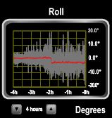 |
5/8/2013: Roll
Winds were predicted to be 15-20 knots, but were 25-30 most of the way, with large, tightly-packed waves on the beam. We frequently rolled to 20 degrees.
|
.jpg) |
5/8/2013: Blueberry muffins
We baked muffins when conditions had calmed enough in the lee of some smaller atolls en route.
|
.jpg) |
5/8/2013: Crossing Tahanea
We crossed Tahanea between 3:30 and 4:30 in the afternoon. All the coral heads were visible a long way off and we easily avoided them except for one where we got closer than we liked before we turning off. On that one, we didn’t see it until 100 to 150 yards away, which is 1/4 or 1/5 of what the rest were. Possibly it was further below the surface and therefore not a hazard.
|
.jpg) |
5/8/2013: Tahanea anchorage
We have a great spot here: we are tucked behind a sandbar, which completely kills the waves around us, but other than the underwater fringing reef, we are completely out in the open. It’s pretty wild. And only tiny patches of coral are around us. This is why we favor the windwards side of the atolls: the bottom has more sand and less coral heads, so we’re less likely to wrap the anchor chain. But the downside is that its further from the dive sites at the entry. The anchor came straight up at Raroia without issue, but having dove the western inside of Raroia, it looked like getting hung up in coral was just about assured.
|
.jpg) |
5/9/2013: Sandbars
The picturesque sandbars that appeared around Dirona at low tide immediately attracted us.
|
.jpg) |
5/9/2013: Small dinghy
We’d taken the large dinghy out to the sandbars, but switched over to the small tender for crossing the shallows to reach the fringing reef.
|
.jpg) |
5/9/2013: At the reef
The fringing reef, where Jennifer is walking, is a foot or so above the water level in the atoll, where the dinghy is secured. To Jennifer’s right, the current is flowing across the reef and into the atoll.
|
.jpg) |
5/9/2013: Waves
Large waves crashed over the outer edge of the reef, supplying the water that drained into the atoll.
|
.jpg) |
5/9/2013: On the reef
Walking along the 400-500′ wide fringing reef. Waves are hitting the outer shore at the right of the pictures.
|
.jpg) |
5/9/2013: Tropical island
Ashore on a beautiful islet near the reef. We have the place all to ourselves.
|
.jpg) |
5/10/2013: Red snapper
We ran the dinghy across Tahanea atoll and found a wall to dive just outside and south of the entrance. As with Raroia, the visibility and sea life were superb. Here, snappers would swim straight at us with apparently no fear or concern. This one followed Jennifer for a few minutes.
|
.jpg) |
5/10/2013: Slingjaw wrasse
One of several distinctive Slingjaw Wrasse we saw at this dive site.
|
.jpg) |
5/10/2013: Orange-finned anemonefish
We saw a few more anemones and anemonefish on this dive, but hard coral still dominates by far.
|
.jpg) |
5/10/2013: Pyramid butterflyfish
.
|
.jpg) |
5/10/2013: The wall
Looking up the wall to Jennifer swimming above. At around 95 feet was an abrupt thermocline, where the water temperature dropped from 88F to around 80F. Today we tried our 3mm neoprene suits instead of the lycra skins, as we’d been getting a little cold. While it seems silly to be getting cold in 88F water, after a couple of hours of diving, we start to get chilled. We much preferred the 3mm suits, and will wear them going forward.
|
.jpg) |
5/10/2013: Between-dive snack
Our anchorage was about 7 miles from the atoll entrance, so we brought four tanks with us to save time and dinghy fuel. We’ve done so much dinghy exploring at Tahuata, Fatu Hiva and Raroria that we’re down to only 10 gallons of the 29 we bought at Hiva Oa. While this still is quite a bit, we still have a lot more exploring to do before we can next get fuel.
|
.jpg) |
5/10/2013: Second dive
We toured around to the other side of the channel to find another dive site, but none appealed as much as the first site. So we returned for a second dive.
|
.jpg) |
5/10/2013: Racoon butterflyfish
Racoon Butterflyfish above a Moorish Idol.
|
.jpg) |
5/11/2013: Morning hug
Spitfire getting his morning hug. Just about every morning, Spitfire jumps up into James’s lap and, in a very human-like gesture, wraps his paws around his neck until they are touching and holds on tight.
|
.jpg) |
5/11/2013: Lifting the small dinghy
We’d built a bridle for the small dinghy to lift it onto the boat deck. Generally though, we find it easier to stow the motor in the lazarette and the dinghy in the cockpit for short runs. For longer runs, we deflate the dinghy and stow it in the lazarette, and mount the motor on the boat deck.
|
.jpg) |
5/11/2013: Chain and coral
The anchor chain is visible about 25 feet down, bending to the left around a small piece of coral. We were lightly wrappped around a few this time. We could see into the water well, and found it easy to disentangle the chain using the Yacht Controller remote helm from the bow.
|
.jpg) |
5/11/2013: Anchor and coral
We’d move to another anchorage a little further south for a change of venue. We weren’t happy with our first set and on raising the anchor to reset discovered why. A large piece of coral was wedged in the fluke.
|
.jpg) |
5/11/2013: Abandon ship!
Jennifer abondoning ship and swimming to shore. One of the appeals of this anchorage was its closeness to the fringing reef and several nearby sandbars and islets.
|
.jpg) |
5/11/2013: Towing the tender
Walking the small tender over the shallows to the fringing reef. The ride is a bit wet, and the seating area small, but we’re very happy with the smaller dinghy. It allows us access to many places we just couldn’t get to in the larger one. And, at just over 60 lbs, with one hand from each of us we can carry it anywhere. In fact, we sometimes use that trick to carry it over stretches of land to access water on the other side.
|
.jpg) |
5/11/2013: At the edge
Enjoying a Hinano (local beer) while sitting in the shallows at the edge of the fringing reef, with the waves rolling in beyond.
|
.jpg) |
5/11/2013: Foundation
A small broken-up concrete foundation was ashore at one of the nearby islets. We couldn’t discern its purpose.
|
.jpg) |
5/12/2013: Coral head
One of several large coral heads we passed as we returned back out through the uncharted portion of Tahanea. We could see hazards such as these a long way off.
|
.jpg) |
5/12/2013: Relaxing run
Sunny and wonderfully calm conditions on our day run to Fakarava.
|
.1.jpg) |
5/12/2013: Dive resort
Several dive resorts and operations are on the atoll–drift diving the entry channels is particularly popular in Fakarava. This one is right on the channel with a view to the swift-flowing current.
|
.jpg) |
5/12/2013: Imagine D
130-foot superyacht Imagine D. Fakarava is much more popular than the last two atolls we visited. We’re now anchored among about ten other boats with more visible across the channel. We saw only one or two other boats the entire time at Raroria and Tahanea.
|
.jpg) |
5/12/2013: Sunset
.
|
_cropped%20(300x225).jpg) |
5/13/2013: Humphead Wrasse
We ran the dinghy outside the pass to dive the south wall. This three-foot Humphead Wrasse is one of several we saw in the area. They can grow up to 7.5 feet long.
|
_cropped%20(300x225).jpg) |
5/13/2013: Yellowback Butterflyfish
.
|
_cropped%20(300x226).jpg) |
5/13/2013: Reticulated Butterflyfish
We’re constantly seeing new species of Butterflyfish on every dive.
|
.jpg) |
5/13/2013: Drift dive
Drift-diving the atoll entry channels is popular. The way to do it without live-boating is to, get this, tether yourself to your tender and drift with the current at 75-100′ below the surface with the tender following along above. At 750lbs, our larger tender would have been a handful to control from below, so we used the smaller dingy instead. It specializes in beach landings and is super-easy for two people to carry around. It’s ridiculously small, but did hold all our gear.
|
_cropped%20(300x225).jpg) |
5/13/2013: Diving tethered
Jennifer on the drift dive watching a reef shark while holding the dinghy tether. The 100′ anchor rode from the larger dinghy is our tether. We clipped it on to her BC, but she mostly held it in her hand with all the line out. We could hardly feel it tugging above and we could just force it anywhere independent of the current it happened to be experiencing.
|
_cropped%20(300x225).jpg) |
5/13/2013: Lots of sharks
One of the draws of this dive is the reef sharks that hang around in the channel. We drifted through groups of 30-50 sharks each.
|
_cropped%20(300x225).jpg) |
5/13/2013: Dive group
This is a popular dive site. One dinghy of diving boaters preceded us to the channel, and several dive boats followed.
|
_cropped%20(300x225).jpg) |
5/13/2013: Dinghy and shark
The dinghy visible at the surface (upper left) as we drift below through the sharks.
|
.jpg) |
5/14/2013: Kit surfer
Kite surfer from one of the boats in our anchorage.
|
.jpg) |
5/14/2013: Nice stern
The stern of superyacht Imagine D folds out to make a convenient platform for transfers between yacht and tender.
|
.jpg) |
5/14/2013: At anchor
Dirona at anchor at a lovely private cove about halfway along the east shore of Fakarava. The cove has good wave protection from all but the west, which is fine with winds predicted from the east to southeast.
|
.jpg) |
5/14/2013: Road
Just in from shore was a road that likely runs the length of the east shore, from the village of Rotoava at the north end of the island to the dive resort we passed entering the atoll.
|
.jpg) |
5/14/2013: Fringing reef
We worked through the scrub a short distance from the raod to reach the fringing reef where waves crashed into the shore. The water here was colder than on the other reefs, as it didn’t reach the atoll, but washed back into the ocean.
|
.jpg) |
5/14/2013: Raft
This well-made raft was washed up on the fringing reef. The supports were made from bamboo, so it likely came from Asia somewhere. The raft had large plastic floation tubes and a bridle as if to be lowered from a ship.
|
.jpg) |
5/15/2013: Sunrise
.
|
.jpg) |
5/15/2013: Rotoava anchorage
Spitfire checking out the scene at the anchorage off the village of Rotoava. Over a dozen boats were anchored there, including three large yachts. Spitfire doesn’t like crowds, and even with several hundred feet of separation between us and the next boat, he always seems concerned that we’re a “little close”.
|
.jpg) |
5/15/2013: Rotoava dock
The dinghy tied off inside the cement dock at Rotoava
|
.jpg) |
5/15/2013: Anchored boats
View to the anchorage from Rotoava. Dirona is the third white speck from the right.
|
.jpg) |
5/15/2013: Plue des baguettes
A load of a dozen baguettes from the bakery at Rotoava, plus a few more provisions.
|
.jpg) |
5/15/2013: Bleach bath
Washing the lettuce in a bleach-and-water bath to kill off any unwelcome critters. We then give it a freshwater rinse and dry it off in a salad spinner.
|
.jpg) |
5/15/2013: Gloria Maris
Nordhavn 86 Gloria Maris at anchor nearby. Including us, this is the fourth Nordhavn we’ve seen in French Polynesia so far.
|
.jpg) |
5/15/2013: Dorothea III
Superyacht Dorothea III at anchor on the other side of us from Gloria Maris. Both vessels had large tenders that they towed behind.
|
.jpg) |
5/15/2013: Cobia III
The supply ship Cobia III arriving at Rotoava. The ship arrives weekly, bringing fuel and provisions. No fuel station is in Rotoava, so purchase are made directly from the ship and dispensed from 200L drums.
|
.jpg) |
5/17/2013: Church
We went ashore for another walk throught the village. The first time into town, we’d mostly just loaded up on baguettes and returned back to the boat.
|
.jpg) |
5/17/2013: Top Dive
Top Dive is one of several dive shops on Fakarava. Their facility looked well-run.
|
.jpg) |
5/17/2013: Black pearls
A black pearl necklace for Jennifer from one of the pearl jewelery stores in Rotoava. The Tuamotus and the Gambier Islands to the southeast are renowned world-wide for their black pearls. Pearl production has been a real boost to the local economy–pearl farms are throughout the area. Besides the coral heads, they can be another hazard to navigation inside the atolls.
|
%20(300x225).jpg) |
5/17/2013: Diving
We ran the dinghy the six miles from the anchorage at Rotoava to dive the wall outside the northern pass into Fakarava. We brought all four scuba tanks to save time, and gasoline. The diving, as at all the atolls so far, was excellent.
|
_cropped%20(300x225).jpg) |
5/17/2013: Cornetfish
These long, slender fish can grow to five feet. We frequently see them while diving here, either alone or in schools.
|
_cropped%20(300x225).jpg) |
5/17/2013: Dive group
We saw two other groups during our dive–one almost ran into us on our safety stop. A little crowded, but an indication that we picked a good site at least.
|
_cropped%20(300x225).jpg) |
5/17/2013: Saddled Butterflyfish
The Butterflyfish of the day.
|
_cropped%20(300x225).jpg) |
5/17/2013: Unicornfish
Easy to tell how these fish got their name. This one is a Whitemargin Unicorn fish about three feet long.
|
.jpg) |
5/18/2013: Pass Garue
About to head through Pass Garue. We’re close to slack, so don’t expect conditions to be difficult. But as a precaution, we always close all the pilothouse and the salon door before going through any rapids. We’ve read of tugboats that have capsized in rapids, where the boat rolled over enough to take on water through an open door and the situation quickly escalated out of control, sinking the boat in conditions that really weren’t boat-threatening.
|
.jpg) |
5/18/2013: Anse Amyot
On a mooring at Anse Amyot. This is a busy place–about ten boats were there when we arrived. Only two mooring were left and the other was picked up before we’d finished mooring to ours. We’ve picked up plenty of mooring buoys in the Pacific Northwest in our previous boat, but this was the first time in the Nordhavn. We’d have felt more secure on our 154-lb Rocna anchor and 7/16″ chain, but swing room was pretty restricted. The moorings apparently are 3/8″ chain wrapped around a large coralhead with a 3/4″ line to the surface. This is reasonable for a boat of our weight, but on the recommendation of the host, and the boat downwind from us :), we also dropped our anchor beside the mooring as a precaution in case it parted.
|
.jpg) |
5/18/2013: Dogs
Spitfire was quite concerned about some dogs barking ashore.
|
.jpg) |
5/18/2013: Sunset
Sunset looking out through the anchorage to the entrance.
|
%20(300x225).jpg) |
5/19/2013: Splash!
Jennifer, in full dive gear, dropping backwards into the water from the dinghy.
|
%20(300x225).jpg) |
5/19/2013: Descending
Ready to dive.
|
%20(300x225).jpg) |
5/19/2013: Resetting the anchor
James holds the anchor rode while Jennifer resets the anchor. We always dive down to check the anchor set on each dive, and frequently adjust it to a more secure set.
|
%20(300x225).jpg) |
5/19/2013: Self portrait
James underwater with fish swimming above.
|
%20(300x225).jpg) |
5/19/2013: Shark
This Blacktip Reef shark swam quite close to Jennifer before it seemed to notice she was there, and darted away. The reef sharks generally avoid humans and don’t pose much of a threat.
|
%20(600x450).jpg) |
5/19/2013: Seascape
The diving at Anse Amyot was fabulous by every measure: excellent visibility, varied and unusual sea life, and a complex seascape. See our “Diving Anse Amyot” blog entry for details.
|
.jpg) |
5/21/2013: Sunrise
Sunrise over the anchorage at Anse Amyot as we depart for Apataki. Only two boats remained after we left.
|
.jpg) |
5/21/2013: Niutahi
Transiting Passe Pakaka into Apataki Atoll with the village of Niutahi coming up on the right.
|
.jpg) |
5/21/2013: Passe Pakaka
We’ve found all the channels into the atolls to be well-marked, often with range markers, and the C-Map charts have been very accurate.
|
.jpg) |
5/21/2013: Panga
A panga leaving the Niutahi boat basin. The village was much larger than we were expecting, with a huge satellite dish mounted near the water and much new construction taking place.
|
.jpg) |
5/21/2013: Across Apataki
Winds were steady 20-30 from the ESE, so we tucked against the southeast shore for wave protection. Scattered corals were on the bottom, but we had no trouble raising the anchor later. We were quite close to the fringing reef, and could hear the waves crashing against it.
|
.jpg) |
5/21/2013: Lunch under the roo
In Hawaii, we realized the cockpit eyebrow bimini wasn’t sufficient for tropical cruising–we needed a way to shade the whole cockpit when the sun is low in the sky. Starr, moored near us at the Waikiki Yacht Club, had a Coolaroo Square Shade Sail for their cockpit, so we decided to try one as a temporary solution. The “roo”, as we call it, has worked out super well. We string it between the boat deck rails and the swim step staples and can deploy and pack it away in minutes. It takes the cockpit from intolerably hot in direct sun to quite comfortable.
|
.jpg) |
5/21/2013: Dinghy secure
The small dinghy tied off to a hole in a piece of coral on the fringing reef and pulling back in the current. The waves crashing over the reef and running into the lagoon created a suprisingly strong current that was difficult to walk against at times.
|
.jpg) |
5/21/2013: High and dry
The small dinghy, and Jennifer, perched on a coral bar near the ocean’s edge.
|
.jpg) |
5/21/2013: Tide pool
The tide pools here don’t have nearly the life of those in the Pacific Northwest, but we did find a few creatures.
|
.jpg) |
5/21/2013: Volcanic fossil
This looks like a coral that was overtaken by volcanic flow.
|
.jpg) |
5/21/2013: Wet seat
Waves from the fringing reef reach our seat nearby.
|
.jpg) |
5/21/2013: Debris
Ocean debris washed up on a coral bar. We found all kinds of stuff, including a plastic spatula.
|
.jpg) |
5/22/2013: Kringele
Kringele, a delicious Norwegian breakfast that’s surprisingly easy to make. Recipe courtesy of the Hacking Family, who are circumnavigating in a catamaran.
|
.jpg) |
5/22/2013: Olive oil
Replenishing the galley olive oil jar from bulk stores. We go through a lot of olive oil–over 2 L since leaving Hawaii 10 weeks ago.
|
.jpg) |
5/22/2013: Replaced components
Today we mostly did boat projects. Some of the compents we replaced, from left to right, are: worn hydrualic raw water pump cover, leaking O-ring at the hydraulic system dual pressure valve, worn hydraulic raw water pump impeller, cracked main bilge pump bellows retainer.
|
.jpg) |
5/22/2013: Spares
We have an extensive supply of spare parts stowed throughout the boat–these ones are just for the hydraulic system. So far we’ve had pretty much everything we need, but we are building up a shopping list.
|
.jpg) |
5/23/2013: Rainbow
Rainbow over the anchorage after a squall. We later left the anchorage in search of a change of scenery and something perhaps closer to the entrance for leaving tomorrow. But pearl farms occupied the shores north and south of the village, and wave protection was poor, so we returned to a spot near where we’d been before.
|
.jpg) |
5/23/2013: Furnace switch
Once a month or so, we like to run the diesel furnace so condensation doesn’t build up in the boiler. But with ambient temperaturs in the mid-80s, none of the thermostats, even at the highest setting, can turn the furnace on. So we installed a switch to force the boiler on for service tasks.
|
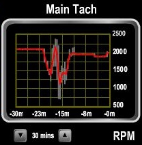 |
5/24/2013: Exiting Apataki
Graph of main engine RPM as we transited Passe Pakaka. The current was ebbing with us perhaps 3-4 knots, with eddies and whirlpools where the channel bent. And to make things more interesting, several locals were paddling across in outrigger canoes where the current was lighter, and a large landing craft was entering the channel directly in front of us. In the graph, you can see the engine RPM changing as we work to maintain course in the strong current.
|
.jpg) |
5/24/2013: Sunrise
Sunrise as we exit Passe Pakaka en route to Tahiti. The channel range markers are visible at the lower the right, almost lined up. Range markers are two posts or marks of different heights, typically lighted for night navigation, that are used to ensure correct positioning when transiting a channel. When the two line up, you are exactly on course. If the closer one is to the left of the farther one, you are too far too the right and vice versa.
|
If your comment doesn't show up right away, send us email and we'll dredge it out of the spam filter.