.jpg)
We left Seattle on Thursday evening and crossed the Columbia River Bar Saturday morning. Conditions were rough, as they always seem to be, in the Strait of Juan de Fuca, but otherwise we’ve had reasonable weather the whole run. Saturday morning prior to 9am, the Coast Guard has closed the bar to all pleasure craft. When we arrived near slack around 9:30, only pleasure craft greater than 45′ were allowed to cross. So we were expecting a beating. As we proceeded, we kept expecting conditions to become at least a little difficult, but they never did. The seas were moderate the whole way across–we would have been comfortable crossing the bar in the previous boat. In fact we would have been comfortable going through in the dinghy.
We’re now cruising up-river. We’re going to cover a a fair distance each day by getting up early, but stopping in time for a good meal and a relaxing evening. And then on the way back down the river, we’ll allocate our time to the best spots we saw on the way up.
Here’s our log from Seattle to our first anchorage for the night off Fir Island. We’ll be making daily live updates to the map view as we go.
.jpg) |
04/19/12: Pennant
Tonight we leave on our trip to the Columbia River. As a going-away present, our neighbours Alex and Christina Marie Kimball from Gypsy Wind gave us one of the beautiful hand-painted pennants that Alex creates from re-purposed sails.
|
.jpg) |
04/19/12, 9:00pm: Foulweather Bluff
With 20-knots of wind and a 1-knot current with us, we’re smoking along at 10.6 knots. Our top speed is 9.5 knots, and we’d should be doing around 8 at this RPM. We’ve been adjusting the autopilot, as the boat is wandering a bit in the following sea. Conditions feel quite calm though. We’re expecting bigger seas on the nose in the Strait of Juan de Fuca–seems like the weather always nails us there.
|
|
04/20/12, 12:00am: Dungeness Spit
The wind has dropped to near zero and conditions are amazingly calm–among the best we’ve seen in the strait. We’re now down to a more expected 7.5-8 knots, but still making good time. We just passed the 279m freighter Hanjin Washington doing 21 knots for Seattle. We’re skimming just south of the traffic lanes and, with the spit to our south, had to pass about a half-mile away. That ship sure looks huge at night.
|
|
04/20/12, 12:40am: NW Dungeness Spit
Vessel Traffic Service can see us on AIS, and just radiod to let us know a ship leaving the Port Angeles area was heading east in the lanes. They also wanted to know our destination. On reporting “Columbia River”, they asked if we’d be stopping in Astoria or Portland, or heading farther up. They paused after I said “all the way to Idaho if we can,” presumably to look that up on the chart.
|
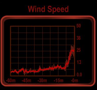 |
04/20/12, 1:30am: Port Angeles
The calm conditions didn’t last long. We’ve now got 25-30 knots on the nose. Seas are 6-8′ and within a second apart. The pilothouse windows are taking frequent spray, and we had to throttle back to avoid pounding into the waves. Not a big deal, but we were enjoying the smoother ride earlier.
|
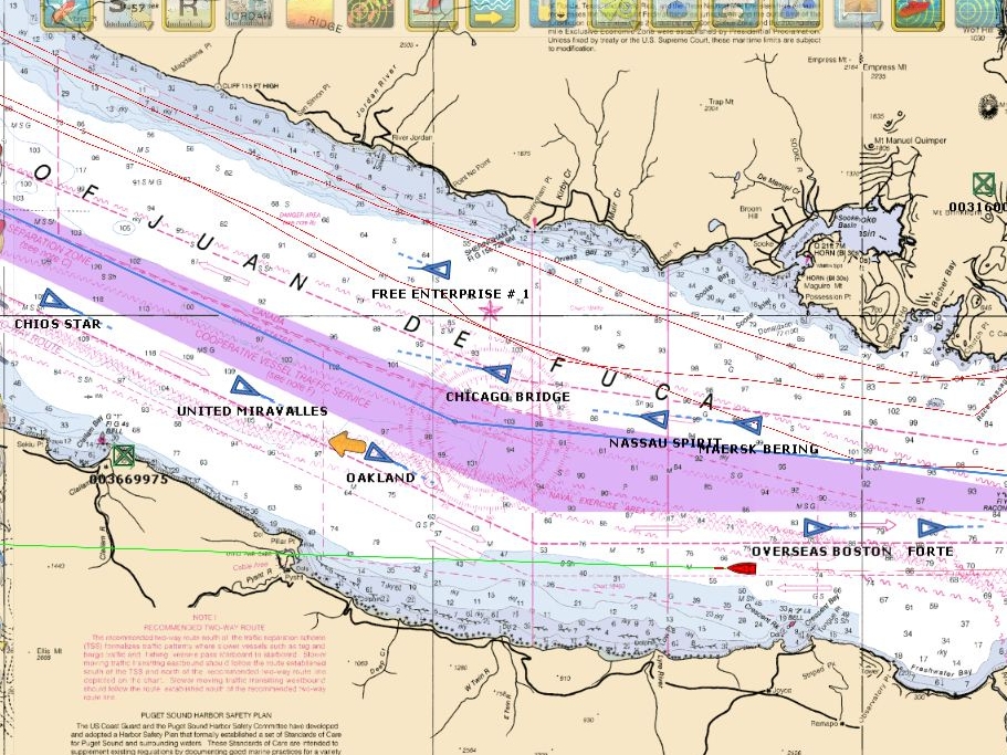 |
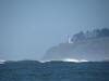
04/20/12, 5:45am Crescent Bay
The wind has dropped to west 15-20 knots now. Conditions have improved quite a bit and we’re picking up speed. Lots of vessel traffic is in the area. We’ve passed a half-dozen freighters already and have four in sight now: Nassau Spirit, Maersk Bering, Overseas Boston, and Forte, with several more visible on AIS.
|
 (600x450).jpg) |
04/20/12, 12:58pm South of Cape Flattery
Our first time boating south of Cape Flattery. Conditions have improved consdiderably–winds are below 10 knots and the sky is clear blue. This sailboat running south with us seems to be having a nice downwind run. We’ve not seen much other traffic since leaving the strait. To avoid crab pots, we’ll be running 12-15 miles offshore.
|
|
04/20/12, 6:08pm: South of La Push
Winds are calm, a moderate swell remains: 10-11′ with a 13-second period. Suprisingly, the Coast Guard has closed the Grays Harbor Bar to pleasure craft shorter than 40′. Weather permitting, we expect to cross the Columbia River bar tomorrow morning.
|
.jpg) |
04/20/12, 8:14pm: Sunset
The sun set tonight in fiery orange ball.
|
|
04/21/12, 9:46am: 1 mile off channel entrance
Coast Guard Cape Disappointment reports 4-8′ seas on the main channel, and 12′ seas and breaking at Peackock and Clatsop spits. The spits are closed to all traffic, and the main channel also is closed to vessels less than 45′. Low water slack was at 9:23 and the Columbia River Bar Pilots recommend going through an hour after.
|
.jpg) |
04/21/12, 10:26am: Cape Disappointment Light
The Cape Disappointment light beyond breakers on Peacock Spit.
|
|
04/21/12, 10:46am: Buoy 11
And we’re through. Conditions were moderate the whole way–we would have been comfortable taking the previous boat through. In fact we would have been comfortable crossig the bar in our current dinghy.
|
.jpg) |
04/21/12: Astoria-Megler Bridge
Heading towards the Astoria-Megler Bridge, that carries highway 101 over the Columbia. This is the first of many bridges that we’ll pass under on this trip. With the offshore run and the bar crossing behind us, the working part of the trip is over. We’re now back to normal cruising mode, under a clear blue sky and a temperature nearing 60F.
|
.jpg) |
04/21/12: Miller Sands
As we head upriver, many of the surrounding islands are thick with sand dunes
|
.jpg) |
4/21/12, Abandoned Cannery at Pillar Rock
The cannery, closed in 1947, looks in remarkably good conditions compared to ones of a similar age we’ve seen up the coast. The freshwater environment probably helps.
|
 (600x450).jpg) |
4/21/12: Fitzpatrick Island
We were planning to have lunch underway, but the waters off Fitzpatrick Island were too inviting. With the temperature nearing 70F, we had lunch in T-shirts on the boat deck. The setting was so nice we almost stayed for the night, but we want to make a little more progress before stopping for the day.
|
.jpg) |
4/21/12: Tensillahe Island
At least 50 boats were fishing off Tensillahe Island.
|
.jpg) |
04/21/12: River Rat Trap
The River Rat Trap tavern in the town of Cathlamet.
|
 (1).jpg) |
04/21/12: Waterfall
One of several waterfalls on the north shore of Cathlamet Channel.
|
.jpg) |
04/21/12: Mount St. Helens
Mount St. Helens seen from the main channel near Cape Horn. The volcano erupted in 1980, killing 57. The volcanic mudflow destroyed bridges and lumber camps on the Toutle and Cowlitz Rivers, and carried 3,900,000 cubic yards of debris into the Columbia River. That would not have been a good day to be out on the water.
|
.jpg) |
04/21/12: Fir Island
We’re anchored in a lovely basin off the northeast side of locally-named Fir Island. We have a view to the main channel on either end of Fir, and south towards Wallace Slough. The river current is running about 2.3 knots, and is pushing us back at anchor. Perhaps a dozen small fishboats are about a half-mile away, and we we expect they’ll all leave by nightfall.
|
.jpg) |
04/21/12: Hanjin Washington
The Hanjin Washington emerges from behind Fir Island, running eastbound in the channel. Several large freighters passed the anchorage, but the pile dike at the north end of the island deflected most of the wake. We felt only a gentle undulation when the ships passed.
|
Thanks for the comment Kevin. We had a great cruise up and a good meal and a couple of beers out on Rooster’s deck watching the river traffic, trains, and the road traffic on the other side of the river. We were a bit "light" on water in front of Roosters with 6’7" on a boat that draw 6’7" and the Corps of Engineers dropping the water in preparation for the spring run off :-).
–jrh
Oh my! I step away from your blog for one month, and you end up in my back yard! I’m kicking myself for not taking the river road home daily like I used to (the one across the way from Rooster’s). I would have loved some photos of her. I believe you may be the first Nordhavn to our humble little port. As always, looking forward to your entries and photos.
Kevin Miller
Thanks for the congratulations Chris. You know, Idaho sure sounds like a weird boat cruising destination but, wow, its been great. The weather is amazing. It’s currently 6:30pm and its still 73 with zero wind. Its been an amazing trip.
–jrh
Hi Jennifer and James. Congrats on making it to Idaho! :-)
We’ll absolutely benefit from the eventual downriver run. I suspect when the trip is done, our fuel burn will still be on the high side only because we have pushed it fairly hard the entire trip essentially trading fuel for time. No regrets at this point!
–jrh
Wow, that’s a lot of fuel – sounds like my burn rate headed over to Catalina for the weekend!
So, maybe a dumb question, but will you benefit from both speed and efficiency when you head back the other way? Or will you potentially still use more fuel than you would intuitively think because in order to maneuver in heavy currents, regardless of direction, it takes more "horsies"?
Keep the photos coming!
How far is a very good question Richard. We’re burning a prodigous amount of fuel pushing hard against a very strong current. At time running wide open with all 266HP in play we were only running 1.6 to 3.0 kts. We’ve already burned around 600 gallons in the less than a weak since leaving. But, the trip is amazing. Its been an entirely different form of boating and we’re having a ball.
We’ll continue to head east and see how our progress maps out to the vacation time we have. At this point, we’re both still interested in heading up the Snake. The junction with the Snake river is only 80 statute miles up stream so we’ll likely get there tomorrow and then we’ll see how far time and inclination allow us to to up the Snake river.
–jrh
Hey James – What a great blog, thank you so much for taking the time to share and post! Earlier you wrote a quote about "going all the way to Idaho…" – At least I "thought" you were joking! How far are you guys going?
Thanks again & safe travels!
Richard Q
Hey Frank, aren’t you reading the wrong blog? Its suppose to be http://perspectives.mvdirona.com :-). Great hearing from you. We’re having a ball on this trip. Today we passed through the Dalles dam ship lock and we’re now at an awesome anchorage. Did a before dinner hike, had a great dinner, and we’re now watching nightfall settle in with the wind power farm north of us slowly turning and flashing red lights to warn off low flying aircraft.
As it gets darker the thermally driven winds are fading and its just beautiful out on the aft deck. Hope all is well in Toronto.
–jrh
You’re right Chris, its an Amazing spot. We hiked up the roughly 500′ cliff directly above the anchorage and, looking back, we could see back to the turn just after the Dalles dam. Turning around and looking up river we could see the John Day Dam. There are wind farms all along the Washington side. We sat up there and watched the Tugs work there loads up and down the river. The only downside is the wind. Its blowing 10 to 20 kts now but, earlier today when we were up hiking over the anchorage was blowing a steady high 20 kts with gusts to 38. But the wind is warm at over 70F and between the wind falling off and the shelter of the boat facing the wind (we’re in a back eddy so the boat is actually facing down river), we were able to eat outside.
Its been an amazing few days.
–jrh
I see we think alike. I was thinking that little cove on Miller island would be a nice place to Anchor for the night. Love the photos again beautiful feel like I’m traveling with you guys. Have a good night God bless.
Chris
Hi, guys. It was almost ten years ago, to the day, when Juimiin and I stopped by one of the parks along your current route. This was the day after we visited you at your old place with the giant aquarium.
Good morning Jennifer and James. I see you have made good progress up the Columbia today. Hows the weather today on the river, Its cloudy and cool here in west seattle today i miss the sun. Have a great day
Chris