Although we hadn’t run overnight before the Alaska trip, we frequently ran at night in the previous boat. And we did make a couple of night runs in the 52. The learning from those two runs proved invaluable in our 24×7 trip. We found that 1) the navigation screens were too bright, even turned down all the way with the software in night mode and 2) the steaming light illuminated the foredeck. Both impacted our night vision. For the navigation screens, we built night-running monitor covers. These were highly effective for the trip to Alaska. Before leaving, we hadn’t yet added attachments to secure the covers, and the screens did occasionally come off that first night in the Strait of Juan de Fuca when boat motion was severe. We secured them temporarily with blue masking tape that night and the following day added small velcro buttons on each side of the top edge of the monitor. The velcro has kept the covers in place even in the roughest conditions. In dimming the monitors, we tended to go through stages as night fell. First we might put the navigation software in dusk mode and later night mode. When night mode became too bright, we’d put the covers on and switch back up to dusk or day mode. Then we’d continue dimming the modes until we had everything back into night mode. And we’d reverse those steps at dusk. With the monitors dimmed properly, other light in the pilot house became more intrusive. This was less noticeable on the Puget Sound night runs in the 52, partly because there was more ambient light. But in the Alaska trip we also needed to dim the VHF radios, the autopilot, and the stabilizers, FLIR, hydraulics control panels. We even put a piece of blue tape over the small red light on the Mathers control. The other night vision issue was that steaming light illuminated the foredeck. Emerald Harbor built a marineboard shield which solved the problem. They also built one for our forward-facing floodlight. Our experience with fishing boats is that the floodlight can be seen from much greater distances in the fog than the navigation lights. It’s not particularly helpful, however, for spotting debris in the water. We had red lights installed in the pilot house, galley, and day head when the boat was built. When running at night with significant ambient light, we’ll put the red lights on everywhere. But on the run to and from Alaska, we found even the red lights in the pilot house too bright, and kept them off underway, turning them on only briefly during a watch change. We even disabled the two forward-most pilot house red lights, finding them too bright period. Having red lights always on in the galley and day head was convenient though, for quick runs down below. We also found a red flashlight handy to study something inside without ruining our night vision, or for the person off-watch berth to read by and not illuminate the pilot house. For collision-avoidance at night, particularly in the fog, we relied heavily on radar and AIS: Furuno DRS25A 25kw 6.5′ and DRS6A 6kw 4′ open-array antennas and an FA150 Class A transponder. We passed perhaps thirty boats at night on the trip up. All came through clearly on radar and about five were fishing vessels that did not transmit on AIS. All the rest, mainly cruise ships, showed up on AIS typically about ten miles away. Night traffic was similar on the return trip, except off Barkley Sound, where we passed through during a fishing opening. None of the fleet were transmitting AIS, and we had to be vigilant to keep a safe distance. We do have a FLIR Navigator thermal imager, and find it effective at picking things out where the temperatures differ. For example, it clearly resolved near-submerged glacial ice chunks that were difficult to see with the naked eye. But on the offshore run, there just wasn’t much out there for it to pick up. We encountered almost no floating debris, logs or otherwise, and our rule at night was to not get within two miles of another boat, which is well beyond our FLIR’s range of about a half mile. The picture below is the north-up radar image off the west coast of Vancouver Island. Our boat is at the center of the screen, the large green circles are 4 nautical miles apart, the blue triangles are AIS targets, the white circle with a line is an ARPA target, and the white diamonds are lost ARPA targets. Approaching us are the cruise ships Sapphire Princess (12 miles away to our northwest), Oosterdam (11 miles north), Norwegian Pearl (8 miles northeast) and Celebrity Infinity (12 miles south). The fishing vessel Island Joy is about 7 miles south. And 8 miles southeast, in the clump of one ARPA target and several lost ARPA targets, the Canadian I is heading south.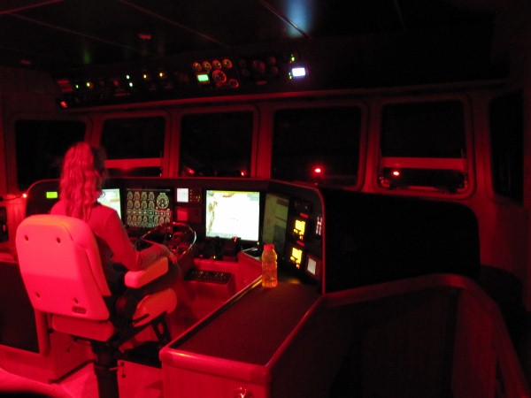.jpg)
.jpg)
.jpg)
.jpg)
If your comment doesn't show up right away, send us email and we'll dredge it out of the spam filter.